OHweather
-
Posts
5,046 -
Joined
-
Last visited
Content Type
Profiles
Blogs
Forums
American Weather
Media Demo
Store
Gallery
Everything posted by OHweather
-
Oof looks like the results in NE OH and NW PA were very disappointing...a little too warm. Probably more chances later in the week with all the cold air coming down though.
-
Holy crap winter came fast this year! Congrats on the "bonus" snow(?) yesterday morning. For tonight's event, it's sort of weird. There's mid-level drying and sinking motion overnight, but instability is moderate to almost extreme with a fair amount of low-level moisture. The flow doesn't move much for several hours overnight into early hours, is very well-aligned and under 30 knots so that does support an organized W-E band that doesn't move too much. Despite the poor synoptic setup with large scale sinking motion and mid-level drying, there is moisture to 7-8k feet into early Sunday with lake to 850mb temp differentials of around 20C which does support moderate to heavy precip with any band (though, the inversion heights do fall short of some recent early season events with a warm lake and again, synoptically it's not a great setup). There is some moisture from Lake Michigan feeding into any band too, especially during the first half of the event. 850mb temps dipping to -7C support accumulating snow if there's an organized band, especially above 1000 feet (though could see something stick at lower elevations under the heart of any band). Overall, I do think enough factors support a decent W-E band tonight and hi-res models also agree unanimously. Given the marginal temperatures I hit the higher terrain hardest for accumulations, but again if the band sits over somewhere then a narrow corridor in the lower terrain can see a little more than shown. If the band wiggles around I struggle seeing anyone getting over 2-3" in NE OH, however, the flow doesn't move too much so it may be somewhat persistent wherever it sets up which could allow for a bit more than I have drawn in here. With a WSW wind over land, I favored the hi-res NAM and NMM for band placement as those models typically show less of a SW bias in their band location than the ARW and HRRR. Into NW PA, with a decent WNW wind over the water I do think the band sags inland into at least Erie County and perhaps northern Crawford County. If that occurs, then the added terrain and fetch there would support a few inches in the higher terrain, perhaps locally up to 6" given potential for rates over 1" per hour and 8-12 hours of fairly favorable conditions. The inland penetration into NW PA is often over-forecasted, but with a good WNW wind over the lake I do think snow makes it at least somewhat inland.
-
Looks like a sneaky few inches of snow in the higher elevations tonight. Will be curious to see if any of you get a decent accumulation! Weird system with an expected brief burst of heavy snow behind the cold front...and then a bit of lake effect into Sunday.
-
The location of the Polar Vortex to the north will determine the outcome of this storm...if it's far enough north this storm will strengthen along the tight temp gradient and could drop a decent swath of snow across central or northern OH, though if the PV is even a little farther south it ends up quite a bit less amped. Sensitive situation. Northern OH in all likelihood won't rain, but how much QPF is a question. Central/southern OH should be a bit safer for at least some precip, but would likely mix or rain with the stronger solution. Almost all guidance including most Euro ensemble members are less amped than the op Euro right now.
-
This winter goes to show how much NE OH's snowfall climo depends on frequent light to moderate snows with an occasional prolonged lake effect/enhanced event. You guys pulled off your biggest synoptic storm since the 2010-11 winter, and are still way below normal. So different here on the east coast where some areas (especially NYC to BOS still) remain pretty far in the hole, but could get a chunk of that back with one storm. NE OH has a hard time making up ground without a rare big storm (either synoptic or LES) if they go a few weeks with little snow, which has happened several times this winter.
-
Yeah, the northern cutoff ended up being a bit abrupt. CLE reported a 1"/hr rate in the 7-8am hour but the radar has been more paltry for Lake/Geauga on east. Not a great northeast OH winter...
-
This should be a half decent thump of snow tomorrow morning (thinking 2-3" for Cleveland and increasing quickly to the south) as it keeps trending north/beefier...but as you guys brought up, it warms up and rains by tomorrow afternoon. Hopefully it's a scenic wet snow when it comes down at least.
-
I think with the last second amped trend and backend lake effect many of your will push or exceed a foot.
-
I don’t personally know him but also follow him on Twitter. Hopefully you guys get plenty of snow!
-
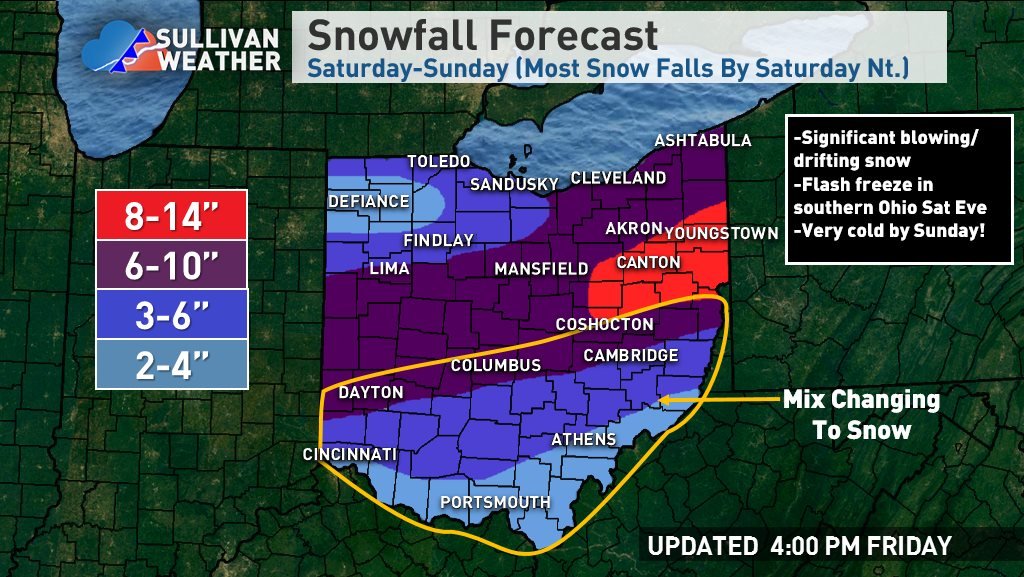
That looks a lot like a Crankywx graphic ^ For NE OH ended up going with a broad 6-10" area. I think the heaviest snow does stay south both with the warm air advection push during the late morning and afternoon and with the evening deform...but, a prolonged period of favorable jet dynamics and isentropic lift causing upward motion in the dendrite growth zone should yield a prolonged period of light to occasionally moderate snow with good ratios. With modest lake effect on the back side through Sunday evening feel 6-10" is easily doable. If the evening deform band can trend a bit farther north can see how spots see over 10" farther north, but my current hunch is that doesn't happen...worth watching though. The WAA snow largely goes south of NW OH so expect lower amounts there.
-
At this point going 6-12" for NE OH... The models have trended towards a sloppier/later phase and more progressive system, though the Euro/UK also came north some from their earlier runs due to less suppression from the PV lobe over Labrador/Newfoundland. This reduces the amount of QPF but does shift the axis north a bit. There will be a mid-level push of warmth into OH but right now all indications are that stays south of route 30 and probably closer to I-70 unless you're a big RGEM fan. Given the trend for a faster storm/less QPF overall, am holding off on any 12"+ totals for now...we will see if the progressive trend can stop soon. There will be enough lift for several hours of moderate to heavy snow on Saturday and that lift will be in the DGZ, so ratios will be decent. If the more amped NAM is right there's certainly potential for over a foot (the NAM probably supports a broad 15-20" this run), but again, the trend has been progressive so hedged under that but still a decent storm. The lake effect potential on the backside is less than stellar with a short fetch, strong-ish flow and dry air, but with some Lake Huron connection and good instability through the DGZ it could be enough to add another 1-3" wherever bands set up. All told feel a broad 6-12" is a good starting point...doubt it drops below 6", would take some work to go over 12" though stranger things have likely happened.

-
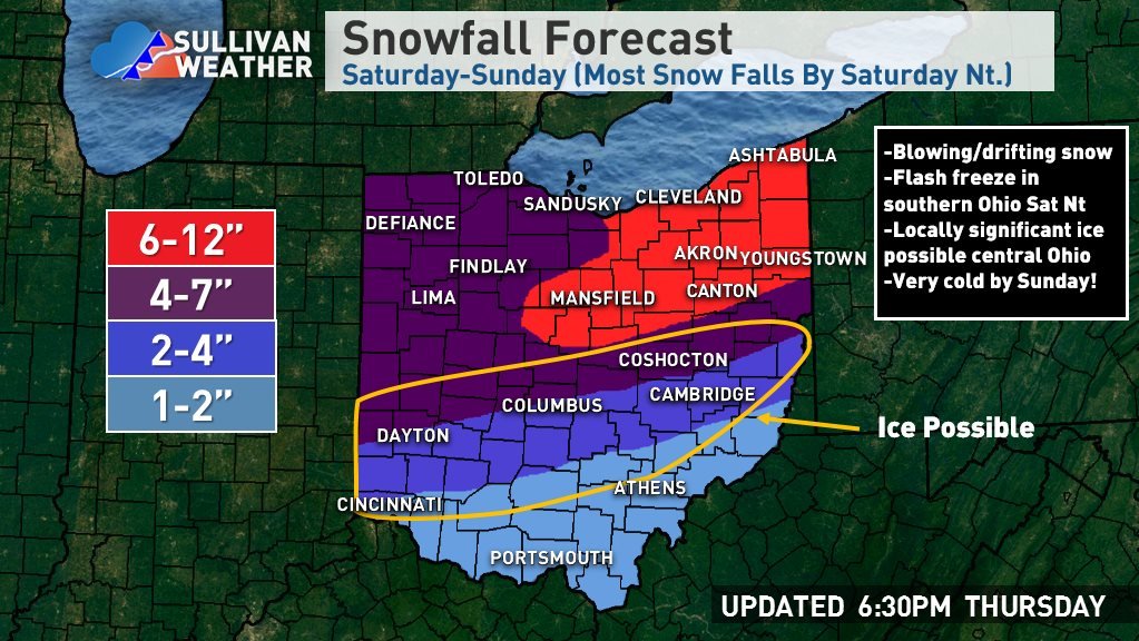
The reason for the sort of SE trend on some models has been due to the polar vortex being focused a bit farther east, making it harder for the southern piece to sneak ahead of the western lobe of it and phase, and also causing more confluence in the height field over the NE and a stronger surface high. The GFS and CMC were faster with the southern piece and still phased, while the Euro, NAM, and UK lagged and didn't phase, hence their less impressive solutions. Given how strong/pressing the polar vortex is, I'd definitely be worried more about suppression than mixing, that's for sure. The 0z GFS and Canadian inched towards a later phase, but changes were borderline noise level...will be interesting to see if the UK and Euro hold. My initial call for the Cleveland/Akron area would be 5-8" but with some more upside if there's an earlier phase. I think even if it doesn't phase well the over-running snow would be decent (and probably good ratios) so you should see a decent amount up there. Would hate to have to put out a number for Columbus because they really could go either way. Because NW NJ dams cold air well and the airmass to the NE is frigid, any QPF that isn't snow here will be sleet/freezing rain. So I am selfishly hoping for the slightly more suppressed route, as exciting as 1.50"+ QPF as "not snow, not rain" would be.
-
I would say be careful, you have a fair amount of margin for error before mixing comes into play and I don't think that becomes a concern north of Rt 30, but we've seen worse trends. Given that mixing is a long way from being a legitimate concern and it'd have to trend considerably weaker (when the overall trend the last several cycles has been more amped) this one looks pretty good for northern Ohio...5 days to go...
-
Casually peaked at radar and some storm reports through the day...nice to see the rare WNW to NW flow event that isn't short on moisture.
-
Yeah, wherever the best band sets up could still see a few inches as winds don’t move a ton, I just don’t think it’ll be that intense. Winds are roughly 290 and reasonably strong so I certainly think the Cleveland metro and southern Snowbelt should see something.
-
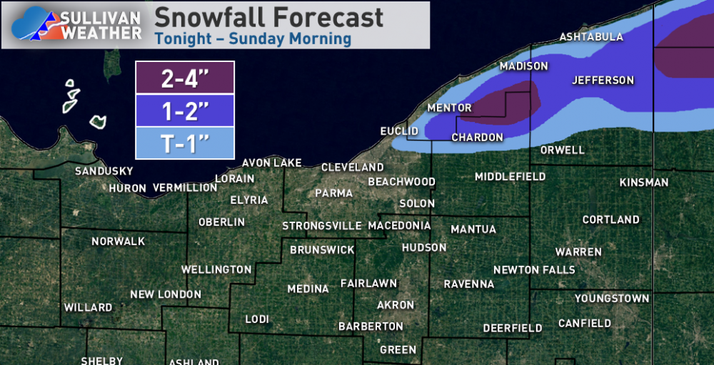
Tonight-Wednesday's leg of the event doesn't look as impressive for NE OH as yesterday when I looked...looks like the Euro idea of keeping the deep moisture farther east will pan out. There's a little shear but it's a reasonably well-aligned WNW flow for quite a while through Wednesday afternoon that isn't too strong with just enough instability and inversion heights of 5-7k feet, so there will still be accumulating snow probably from northern Lorain County points east, but I just don't know if the intensity will be there for more than a broad 1-4" of additional snow, focused wherever the convergence band develops and maybe in the higher terrain of northern Geauga as well. NW PA still gets into the deep moisture with a longer fetch and more terrain, so additional amounts in eastern inland Erie County will still probably justify the warning, especially since some of those areas already have 6-12" and will probably get that much more...though west of I-79 there will likely be a drop off somewhere to much more pedestrian amounts.
-
Looks like two shots for some snow the next few days...first Monday night into Tuesday morning with some initial wrap-around and lake enhancement...my impression is it's 2-4" in the higher terrain of Geauga and 3-6" for the higher terrain of Erie PA and SW NY through Tuesday afternoon...it's an ok but not outstanding setup, synoptic moisture decent but winds rather westerly and instability limited. So there should be accumulating snow in the usual spots, maybe pushing advisory criteria for some, most likely in parts of Erie County and the Chautauqua Ridge. The next period is Tuesday night and Wednesday when the models drop another vort max and good moisture through. The Euro is more of a clip job for NE OH while the NAM would be very good back into NE OH. With a WNW wind, colder temps, and longer duration, that's the window that could produce a substantial accumulations perhaps worthy of a warning...highest confidence again in the higher elevations of NW PA/SW NY, though if the NAM is right (and it's only a small shift west for the Euro) that could get as far west as the higher terrain of Medina County. A prolonged lake enhanced event with decent ratios, upslope and broad shoreline convergence with a WNW wind, and good moisture and instability would do quite well.
-
Yeah, that band got amazingly stuck.
-
I suspect a better band will flare back up within an hour or two as the rather sharp trough moves across the lake...it won't be 2" per hour like they saw from Erie to Dunkirk this morning but should be moderate at least. The question for some of you will just be how far south it can get.
-
I think northern OH sees a light snow, but it’s not a strong system and temps aren’t that cold so probably a 1-2” deal (less near the lake). Maybe some LES behind it but that doesn’t currently look fantastic.
-
The NE corner of Ohio and parts of Erie County got a good amount this morning, already a 9” report SE of Erie. Hopefully the bands are intact later and can make it far enough south for some of you to see something.
-
Since it's been pouring and 45 degrees here all afternoon/evening, one more pass at this... A band will ramp up over the lake this evening by 7 or 8 PM as the first of a few troughs pushes across the lake. Winds ahead of the trough are WSW if not SW, so this initial band will likely set up parallel to the shore and come inland into Buffalo and its immediate southern suburbs. Temperatures ahead of the trough are cold enough for plenty of graupel given the developing instability, but don’t quite get cold enough for a change to all snow and potential accumulations until after it passes. This band will likely push inland a bit and shift south of the Buffalo area by 11 PM or Midnight as the trough passes. Winds behind this trough briefly come around to about 270 (due west) over the lake and remain firmly south of west overland. This will likely push the trough into Erie County PA within 10 miles of the lake (as well as Chautauqua/northern Cattaraugus NY)…it will probably be able to graze Lake//northern Geauga/Ashtabula Ohio but will not push far inland. As the trough pushes through temperatures will quickly fall to levels that typically support accumulation with intense, early-season bands so the precip will change to all snow/graupel. This initial push will not last long and temps will only become supportive as it passes, so I’m guessing that other than perhaps some car toppings of graupel there won’t be any accums this evening in Buffalo proper…but could be a quick inch or two inland over southern Erie Co NY, and also where the band impacts in northern Erie Co PA and in Chautauqua/Cattaraugus. There may be dustings in extreme NE OH if the band makes it on land there. The winds quickly start backing again after 2 AM ahead of the next trough. This will likely cause a more consolidated band to quickly re-develop that starts shifting up the shoreline. As this occurs, extreme northern Ashtabula Co could get a dusting late tonight. Parts of Erie Co PA will also likely get an hour or so of snow as the band lifts back north during the pre-dawn, and given its likely intensity that will cause some quick accumulations. The winds by morning get to be WSW over water and nearly due SW over land. This should still lift the band north of the vast majority of Erie Co PA…though it could graze the extreme NE portion. Despite models taking the band into the Erie PA area into Chautauqua County in this time period, I simply don’t see how it can push inland that far south given the winds…this fits with the known bias of modelling being too far south with these bands. I suspect it will sit near the lakeshore between Northeast, PA and Dunkirk, NY and then actually come inland near or a bit north of Dunkirk and affect extreme NE Chautauqua Co, the NW tip of Cattaraugus, and southern Erie Co NY, probably getting back into the southern Buffalo suburbs. Winds will support the band in this general area for several hours from before sunrise Saturday through 1 or 2 PM. The character of the band and whether it actually stalls or keeps slowly moving will determine how much snow it can dump. Extreme instability (lake to 850 diffs of 25C, lake to 700 diffs of 35C, and lake to 500mb diffs of 45 to briefly almost 50C) resulting in boundless inversion heights of 15-20k feet, deep moisture to above 10k feet, little directional shear and good synoptic support as a 500mb low moves just north of the lake suggest very heavy snow under the band. Snow ratios won’t be much higher than 10:1, especially near the lake where they’ll be lower, but it will be puking thundersnow and will still pile up quickly, if there is an organized/persistent band. The wind speeds in the boundary layer over the lake will be 35 to 40 knots which is stronger than preferable, but with a full-fetch of the lake, the flow favoring good shoreline convergence into SW NY, and broad synoptic convergence ahead of the approaching trough all argue for a persistent band. Given the strong shoreline convergence in this area, I suspect the band will drift around in the same general area for 6-8 hours Saturday morning/early afternoon before the trough passage pushes it south. This still isn’t a high confidence forecast, but given the likely rates if an organized band occurred the potential still remains for locally up to a foot of snow in a short time by early Saturday afternoon in SW NY, including southern Erie County NY and the southern Buffalo suburbs. Given the wind speeds and short window, I will say that I’m not as confident as I would like in a focused area of persistent enough snow to get that, but I think the potential very easily exists with multiple factors still arguing for it. As the trough pushes through the band will likely intensify back to the central basin, especially with some Lake Michigan pre-seeding, and then swing southeast into much of the Snowbelt from the western suburbs points east. Winds on land are still not expected to veer north of WSW Saturday afternoon/evening over Ohio or NW PA, which is reasonable since the upper trough rapidly pulls east by that point and surface ridging builds in from the SW. But, winds over the lake come around to 280-290 degrees (WNW) for several hours late Saturday afternoon through the entire evening. This push over the lake should still allow for shoreline convergence over Cuyahoga County and perhaps even NE Lorain County for a time, allowing for the band to get into the immediate Cleveland area and western lakeshore, then moving inland near or north of 322 into the eastern suburbs and Geauga County. It should push into central and southern Ashtabula County for a time, and though the inland penetration in NW PA will face similar issues to OH, their farther north location will likely allow the snow to briefly get as far south as northern Crawford County. Instability is still moderate to borderline extreme by later Saturday afternoon as the band affects more of the NE OH and NW PA Snowbelt with inversion heights of over 10K feet, which along with strong convergence caused by the trough interacting with the shore should still allow for moderate to heavy snow. Temps begin moderating some by later in the day so the lakeshore will likely be snow under the heaviest band but then may struggle once the intensity drops…so I’m thinking maybe a quick coating to 2” along the lake from Cleveland up through Ashtabula County, but not more with this band. Inland it could be more like a quick 1-3” or so, especially if the band stalls for a few hours in the early-evening. Overnight the low-levels remain very unstable over the lake and winds will remain well-aligned, with convergence continuing over the Snowbelt as surface high pressure continuing building in from the south. Inversion heights and moisture depth decrease, but strong low-level instability, lack of shear, and convergence should still allow a moderate band or two to continuing through the night. It will slowly lift north through the NE OH Snowbelt and into Erie County PA overnight. Because the bands won’t be as intense and will slowly be moving, I’m lowering my expectations to 1-3” of additional overnight accumulations inland from the lake in the NE OH Snowbelt north of 322 and in the half of Erie County PA closer to the lake…suspect southern Erie County dries out overnight. The remnant band will get into SW NY Sunday morning, but will be quickly shifting by then and the high will really begin choking it off, so likely no additional accums with it in NY Sunday morning. Given the moderating airmass overnight, the bands may struggle to accumulate much additional snow near the shore. For the map and changes to it, focused the 6-12” corridor in NY where they’ll see the best potential snow tonight and also where the band is likely to affect Saturday morning. Removed the 4-8” from anywhere in NE OH as I don’t think they’ll see much if any tonight, and I’m not quite as impressed with the Saturday night snowfall there…but the higher terrain north of 322 from NE Cuyahoga into southern Lake/northern Geauga should still get a good few inches Saturday afternoon and evening. Did expand the 1” into more of northern Cuyahoga County given potential for a relatively intense band to affect that area for a time late Saturday afternoon/early evening. Reduced the area of 4-8” in Erie County PA for similar reasons as in NE OH, and mainly focused it on the NE corner where better banding will graze late tonight through early Saturday afternoon…that’s not to say that someone can’t squeak out locally more than 6” in central or western Erie County PA if a more persistent band sits there later Saturday afternoon or evening, but I don’t have enough evidence to support it in any given spot. Did bump Erie proper into 3-6” since I think they see a brief burst late tonight, get grazed Saturday morning, and get another good burst early to mid-afternoon as the trough pushes through…though that’s admittedly low confidence, and I feel more confident farther up the shore. 1-3” amounts were extended farther SE overall in NW PA and SW NY on the southern edge to give a nod to most guidance, though didn’t go as far as some models due to likely issues with banding getting too far inland.
-
The winds over the lake come around to about 290 which usually is good for down to 422, I’m just worried that the winds inland stay WSW. It could be close for you at least. This morning was definitely a surprise, must’ve come down hard. Actually got a few sleet pellets here with temps in the low 40s so I guess I’m on the board this winter as well!
-
The lake effect Friday night through Saturday night is intriguing, though wind direction may not be great for some of you. With the synoptic precip Friday morning temp profiles are close to supporting snow...there will be some dynamic cooling as lift is pretty good and the precip will be moderate, so the higher terrain in NE OH and NW PA will probably try to flip to snow for an hour or two...it may be enough to try to start lightly coating grassy surfaces and such...lakeshore probably just sees rain. NW OH a bit colder and better timing so will probably be some grassy accums there to start Friday. For the lake effect over the weekend, it's honestly more impressive than I initially thought parameter wise, but some questions about the duration and wind direction make it hard to be confident about a lot of snow falling in any given spot. My impression based on the parameters alone is that someone will hit the 6"/12 hour or 8"/24 hour warning criteria, but a band will need to lock in somewhere for that to happen. The band will start taking shape late Friday evening as winds line up out of the WSW. With an approaching upper-low and extreme instability developing, it will likely be intense...it may graze the Lake, Ashtabula, and Erie lakeshore for a time, but at some point between 1 AM and 5 AM Saturday will lift out over the lake and come inland south of BUF as winds go more SW. The band will likely be mixed before midnight, but after midnight as 850mb temps crash to -10 to -12C by daybreak the band will be all snow/graupel down to the shoreline given its likely intensity. Winds lock in for a few hours Saturday morning, which could allow the band to slow enough to drop substantial amounts on parts of SW NY along the lakeshore and inland into the southern Buffalo suburbs. Instability will be extreme, with equilibrium heights of near 20k feet thanks to hilarious lake-to-500mb differentials of -45C (approaching -48C briefly). Wind speeds will be strong, but when the band is completely parallel to the long axis of the lake that should allow it to be organized enough. Given the instability, large-scale lift with the upper-low, full-lake fetch and strong convergence the band into SW NY will have a lot of lightning and likely contain very high rates...despite the wet snow, over 2" per hour will be possible. Even though the duration is only a few hours, the possibility exists for up to a foot in SW NY if the band locks in Saturday morning. This could graze northeastern Erie County but I suspect if it locks in it does so just up the shore from Erie proper...though they could get grazed for a time late Friday night/early Saturday and see some snow. The band will swing into most of the primary NW PA and NE OH Snowbelt Saturday afternoon as a surface trough pushes through and brings the winds around to the WNW over the lake. It probably won't sit over the lakeshore for more than an hour or two as the wind shift is fairly sharp and abrupt, but given the likely instability and forcing it could drop a quick inch or two of snow/graupel near the shore. As for how far south the band can push and what kind of amounts it can drop inland, winds on land don’t really back from WSW as the surface high starts building in quickly Saturday evening. With WNW winds over the lake the band can probably get down to about Downtown and then push east across NE Cuyahoga and into northern Geauga, north of 322. It should get into central and southern Ashtabula as well as most of Erie County, but likely struggles to push into Crawford PA. It may maintain this southern extent for a few hours before drifting back north Saturday evening. The upper support quickly departs late Saturday afternoon and the inversion height lowers substantially, so the band intensity will likely be more moderate when it reaches its southernmost point…it could drop a light/slushy accum on the Cuyahoga lakeshore from Downtown points NE and perhaps a quick 1-3” inland in a few hours. Overnight Saturday night instability does remain sufficient as the ridge builds in and slowly backs winds over land and pushes the lake effect back up the shoreline. With lightening wind speeds and lake to 850mb diffs remaining easily over 20C through the night, it wouldn’t surprise me if a moderate band or two does reorganize from parts of Lake County and perhaps the chimney of Geauga northeast across northern/central Ashtabula County and northern/central Erie County PA, perhaps into Chautauqua County NY as well later in the night. This band won’t be as intense, but will have light winds and good convergence so should be organized and likely won’t move quickly, so it could drop another 2-6” overnight Saturday night into early Sunday where it sets up. Overall the potential for heaviest snow will be Saturday morning in SW NY and perhaps extreme NE Erie County, and I’m thinking a quick 6-12” with that where the band sets up…shouldn’t have issues accumulating along the lake given temps aloft and the expected intensity. Expecting a quick 1-4” across the primary Snowbelt as the band swings south Saturday afternoon/early evening before lifting back north…in Cuyahoga and Geauga Counties this is likely confined to along/north of 322 as it looks now. I expect another few inches in the northern Snowbelt overnight Saturday night into early Sunday as bands re-organize and slowly drift north as the surface ridge builds in and as enough instability hangs on. Forgive the crude map, I never had a chance to make a nicer base that included NW PA and up to Buffalo last winter and don't right now either. I will likely adjust this Friday at some point since I'm off and we're getting another monsoonal here tomorrow afternoon/evening, to nail down the SW NY band better and take another look at the Saturday night amounts/placement.
-
My early impression is that this weekend won't do much...the cold shot is brief and winds quickly go back to the SW. It'll be so cold that if a brief period of LES developed it'd accumulate inland, but I don't think there's much potential for a decent amount. Next week's cold shot at this point looks much deeper/slower moving and could feature a west to northwest wind. The lake to air temp differential should be extreme given lake waters still in the 50s and persistent signals for impressive to near record cold with this airmass, so details certainly to be worked out but that could lead to a significant event somewhere between Monday and Wednesday of next week.