OHweather
-
Posts
5,046 -
Joined
-
Last visited
Content Type
Profiles
Blogs
Forums
American Weather
Media Demo
Store
Gallery
Everything posted by OHweather
-
2.1" of LES last night for a total of 3.5" of LES
-
I'm thinking many areas will get into the forecast ranges from yesterday. Not really exciting though but getting there. Was a general 1-5" through this morning from the east side into Geauga County, and the bands been moderate this afternoon into NE Cuyahoga, southern Lake, and northern/west-central Geauga and likely has added 1-3" in those areas. Another vort max passes through early to mid evening which should result in a minor uptick and also send the snow farther south. With light winds over the lake going NNW tonight expect convergence to focus at least snow showers within 10-15 miles of the lake most of the night from Lorain County points east, with potentially moderate snow from a Lake Huron connection into Erie or Ashtabula Counties. With light winds and very cold air on land still think there's some risk for a meso-low perhaps over the central basin that could graze the coast with heavier snow. All in all a real slow burn but much of the east side points east will end up with at least a few inches from last night through tomorrow morning, with locally probably upwards of 10" in northern Geauga County where they had 4-5" through this morning and are under decent snow now.
-
The 0z models last night hinted at this happening with the winds going more NW this evening. So we may continue to see a semi-coherent band through the afternoon, shouldn't lift too much farther north. Somehow Chardon got 5" last night, some spots may see a few more inches through tonight as light snow may continue within 10-15 miles of the lake much of the night. It was snowing half decently here all morning but with poor flake size and I got another half inch give or take. I may hit 2-3" and can see spots just a bit north of me seeing a 5 or 6" total considering Shaker already has 2" and should continue to see more snow for quite a while.
-
I'm not sure what we have to do for an event to not completely fall apart. The band was reasonably intense as it approached the downtown lakeshore then broke up/weakened quickly. I suppose the good news is it should snow very lightly most of the day. Around an inch here.
-
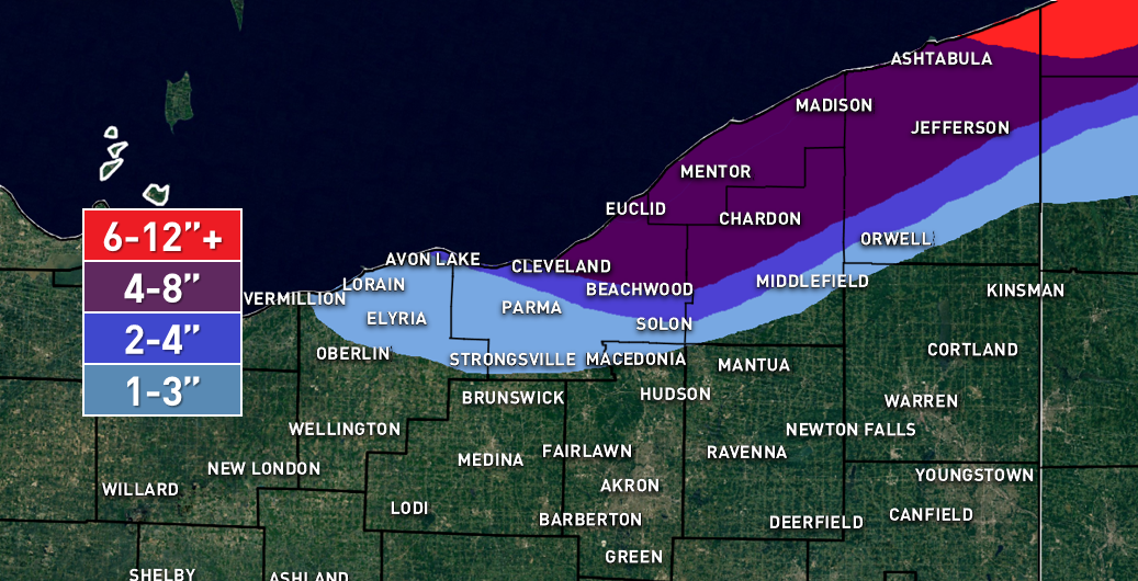
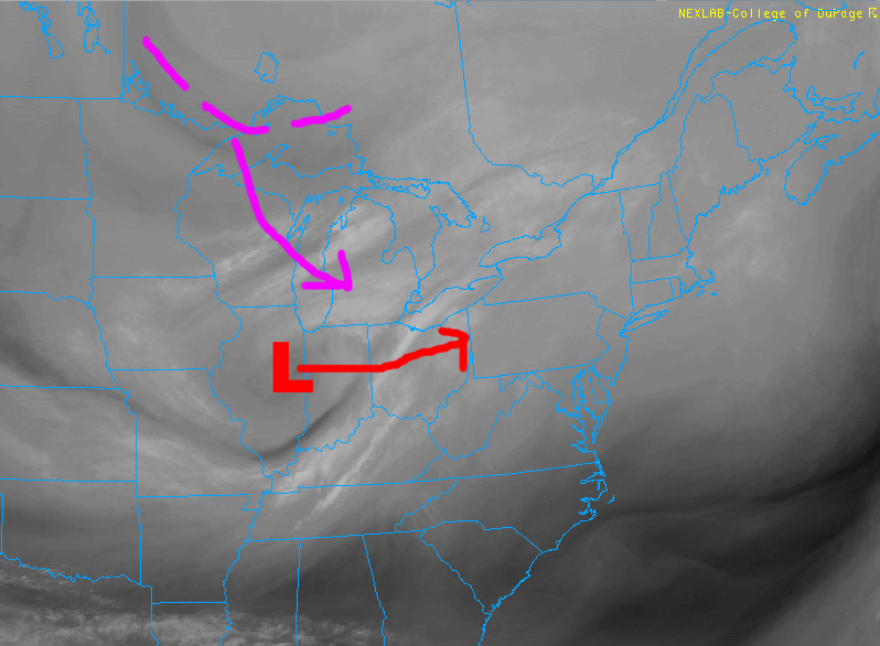
This is a pretty interesting/tough forecast for the remainder of this LES event through Wednesday night... Indications are the band (which the heart of is actually north of Erie at the moment) will reach its farther north point by 7-8pm, and then begin sinking back south as a weak surface trough evident over SE MI pushes east this evening and causes winds over the lake to shift from SW to more west. This should allow convergence to increase from near Euclid up the shoreline and allow decent snow to develop up the shoreline in NE Ohio by mid to late evening. As winds on the lake continue to gradually veer to more WNW after midnight, the snow will likely push inland into more of NE Cuyahoga and northern Geauga County. Given WNW to almost NW winds over the lake I have to imagine it will push inland over Erie County as well. The band will likely stall or really slow down for several hours after midnight or 1am, especially across the eastern Cleveland metro. This is due to the winds on the lake not moving much, possibly in response to the mid-level shortwave approaching/moving overhead, and due to the shape of the shoreline near Cleveland likely focusing shoreline convergence in that area for several hours. The hi-res models have a known bias (that has been on display constantly this event) to underdo shoreline convergence and push bands inland too quickly. Given where the models place the band, the expected wind direction, and shape of the shoreline, my guess is it will lay near the western lakeshore (perhaps nipping land at times very close to the lake west of Cleveland) and then move inland near or just slightly NE of downtown and then push ESE through the eastern suburbs towards Chesterland and South Russel. The NAM and RAP both have a crosshair signature for several hours late tonight (strong lift in the DGZ and decent RH in the upper half or so of the DGZ), which along with moderate lake-induced instability and EL heights of 9-10k feet suggests the band will produce heavy snow with rates of 1-2" per hour. Given it may move little for several hours, the potential for several inches of snow exists in the eastern suburbs into northwestern or west-central Geauga County. With some large scale lift from the shortwave passage think the higher terrain in the rest of the northern Snowbelt will hang on to snow showers in this time, but nothing too organized or heavy. If this band pans out could see some spots get near 8" by morning under the band in the eastern suburbs. The shortwave finally passes Wednesday morning, resulting in some sinking motion and winds veering even more to NW over the lake. As temps on land warm the lake-aggregate trough and shoreline convergence should weaken, causing the band to swing southwest and become less organized. The band will likely lose its lake Michigan connection Wednesday afternoon. Even so, moderate to borderline extreme instability may result in snow showers continuing from Lorain County points east, likely heaviest a bit inland given no dominant band or shoreline convergence. These may result in additional light accumulations late Wednesday morning through the afternoon. The combination of a cold and somewhat drier airmass may limit snow growth late Wednesday morning and beyond, possibly limiting ratios with any snow showers that persist, so I suspect amounts after about 10am Wednesday through the rest of the day will be reasonably under control. I still don't trust Wednesday night not to produce some additional accumulations. With winds going NW to even NNW a Lake Huron band may set up over NW PA and produce a couple inches or so. As temps drop on land convergence will increase along the rest of the shoreline. With winds going very light after midnight, some "tea kettle" snow may result with convergence near the shore just spilling inland, possibly dropping accumulating snow near the shore. This could occur as far west as Lorain County. The light winds and extreme temp differential between land and water may support meso-low formation too, which could also brush the shore with some accumulating snow. Any lingering snow should end Thursday morning. For additional accums, given the band gradually progressing south tonight think a general 4"+ is doable over most of the northern Snowbelt. I kept amounts at 4-8" over the eastern suburbs into western Geauga County, though I can't rule out a higher amount if the band after midnight into early Wednesday remains stationary enough. A few mile bust in band location results in a lot of population seeing different amounts, so that's a sensitive forecast which also factored into my decision not to pin down a 6-12" area. Think the period of snow along the shore tonight along with the potential for tea kettle lake effect Wednesday night supports 4"+ additional snow even along the coast. With the band currently affecting extreme NE Ashtabula County and coastal Erie County, along with a potential for a Huron connection early tomorrow night and tea kettle snow after midnight that 6-12" (locally more) is doable in those areas. The inland penetration of snow in NW PA is tough, but think once the band swings south later tonight with a quick accumulation that enough opportunities for snow showers (especially if some Huron moisture is involved) exists for at least a few to several inches of total additional accumulation in inland Erie County possibly clipping northern Crawford County.

-
It's a shame we don't have radar for Erie. This has been an incredible event for them. The winds on land are just perfectly parallel to the shore from Ashtabula to Erie, so though the winds over the lake have been moving a good bit over the last 30 hours the band just hasn't moved from the shore there. Perfect setup. It did finally push inland briefly earlier today but is back to pounding that area again. The obs are extremely impressive, with hours on end of quarter mile or lower visibility. I do agree that the earlier month snow totals don't seem right. Either the depth or snowfall is wrong. There are a few days where there's a seemingly impossible snow depth change compared to the amount of new snow recorded. I'm going to look over the LES for northern OH one more time here over the next little bit and see if I have any positive thoughts or not.
-
I do agree with your concerns about the band struggling to push inland. I do think it moves onshore over much of Cuyahoga County may but only affect the northern half of the county into northern Geauga. Most models push it farther south sooner or later but that is probably overdone. As for the ice I was just looking at GOES 16 and you can definitely see some has developed. Relatively thin ice still has a decent heat/moisture flux so I'm actually not that worried about it for the next day or so...you can see some clouds forming over the ice currently and feeding into the band...but it will become a bigger deterrent as it thickens and expands over the next week, which is unfortunate because we've gotten very little lake effect this season locally.
-
The band wasn't really expected to get too far south this morning (some models showed it but their bias is showing pretty nicely here). I hoped it would get to around route 6, it's a few miles north of that. Unfortunately, it still hasn't really detached from the lake in Erie County, and I'm sure there'll be huge totals near the shore in Ashtabula and Erie Counties. The winds will come around to 290 or so later tonight into Wednesday morning so the band will push south. The winds won't be that strong so the band will likely again try to hug the lakeshore more than the models show, but even so it should get into much more of Cuyahoga and Geauga Counties. The GFS has steady winds at around 295 for several hours which would possibly let the band sit for a while just north of 480/422, while the NAM brings them around to the NW quicker. Given the bias to push bands south so quickly the GFS solution may be better.
-
The winds over the lake along and north of the band are west right now, causing the band to line up how it is. On land, it's considerably colder (and that air is denser) and the winds are more WSW. So when the band hits the denser air along the shoreline in extreme NE Asthabula and Erie Counties and air blowing offshore, it tends to parallel the shore. For some reason models often under-do this effect and drive bands inland too quickly. Winds on the lake are expected to go more WNW later tonight through Tuesday morning, which will hopefully push the band inland. It's been very impressive in northern Erie County, and I can understand your frustration. I do think you'll have a couple opportunities for snow through Wednesday night, but sadly won't get the huge totals northern Erie County has seen. My monthly total is running at 13.8" right now. Have to imagine that's relatively close to normal for here.
-
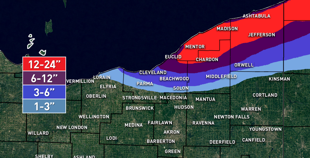
Here's my first guess on the LES...I'm trying to sneak in a nap before the Cavs play so this write-up will be a little more curt than normal with no images. Winds will turn around to a more due westerly direction over the lake this evening behind a weak mid-level shortwave, which should allow convergence to move back south to northeastern Lake County and northern Ashtabula County and re-intensify over northern Erie County as we head into tonight. This is expected to allow the lake effect snow band to push back onto land near the lake in this area. Convergence will be strong near the shoreline with moderate lake-induced instability to go along with ample moisture below about 6-7k feet and EL heights of 8-10k feet (lower at CLE higher at ERI). BUFKIT shows lift focused in the DGZ along with high RH through most of the DGZ promoting high ratios, which along with the convergence and decent but not outstanding instability should allow for 1-2" per hour snow rates thanks to the ratios in the band. Some pre-seeding from Lake Michigan is also expected to develop tonight, which along with weakening winds maximizing residence time and a long fetch should allow the band to take full advantage of the fairly good parameters in place. The band may move little from this evening into the overnight, and may produce 6-10" of snow in a few or several hour period of time where it affects. The most likely area to see this will be extreme eastern Lake County, northern Ashtabula County, and the northern half or so of Erie County, PA. All models show the winds coming around to a solid WNW direction over the lake late tonight through Tuesday morning, which should push the convergence and band a little farther south. Winds inland will remain WSW, and a strong temperature difference between over water and inland should result in a strong lake-aggregate trough, which along with the WNW winds not being terribly strong argue against the band pushing very far inland. The hi-res models do try to push the band as far south as Downtown and NE Cuyahoga/central Geagua/southern Ashtabula County. Given the aforementioned factors and known bias for models to place LES bands a little too far south, my guess is we'll see the band get to extreme NE Cuyahoga County (Euclid/Mayfield area) but not quite to Downtown and then points east into Lake County and Geauga County mainly near and north of route 6. It may briefly get as far south as close to 322, but I'd hedge on heavier amounts being closer to 6. With a solid WNW push of winds, the band will probably push south of the Ashtabula County and Erie County lakeshore for several hours late tonight into Tuesday morning. Parameters remain similar to those described above, which should allow rates of 1-2" per hour to continue under the heart of the band. Winds may move slowly enough for a the band to be relatively stationary for a few hours, possibly allowing another 4-8" of snow to fall under the band late tonight through noon Tuesday. The area most likely to see this will be Lake County, northern Geauga County, Ashtabula County just inland from the lake, and perhaps far northeast Cuyahoga County. Tuesday afternoon the winds will back to the west/southwest over the lake ahead of a more robust shortwave, likely causing snow to lift north and potentially reorganize for a few hours over northeastern Ashtabula County into Erie County, possibly dropping another corridor of several inches of snow fairly quickly. Behind that wave Tuesday evening through Wednesday the winds will gradually veer and instability/moisture depth will improve. Winds inland will remain WSW and a strong temperature differential will remain between the lake and land, likely maintaining strong convergence near the shore. This will push the band back down the shore and gradually a bit farther inland Tuesday night into Wednesday. It may affect the northern Snowbelt (extreme NE Cuyahoga, Lake, northern Geauga, northern/central Ashtabula, parts of Erie County likely a bit inland) for a few hours later Tuesday evening as the winds on some models get hung up a bit ahead of another little 700mb vort max. EL heights of near or better than 10k feet (higher on the ERI soundings) and good moisture to 7k feet, a long fetch with relatively weak winds/little shear on soundings over the lake, moisture from Lake Michigan, along with a saturated DGZ and strong lift centered in the DGZ in the band on both the GFS and NAM suggest the band could produce very efficient and heavy snow, with rates of 2 to perhaps 4" per hour likely Tuesday evening. If it slows/stalls for a few hours over the northern Snowbelt, that corridor would see an additional 6"+ quickly and possibly up to a foot in short order. The band should resume its southward drift around midnight or so behind the vort max and should get into much more of Cuyahoga County. This will be an interesting setup for Cuyahoga County late Tuesday night through a good chunk of Wednesday. Models show winds of 285-295 degress with a clear trough axis near the county, with CLE BUFKIT soundings maintaining extreme instability, EL heights of near 10k feet, moisture in the lowest 5k feet at least (higher through mid-morning Wednesday), and lift centered in the DGZ. A Lake Michigan connection should maintain through most of Wednesday and winds will be fairly light/well aligned, maximizing residence time and it won't be a short fetch. There is enough juice for a warning criteria snowfall over much of northern/eastern Cuyahoga County including in or near Cleveland into central/southern Geauga County late Tuesday night and through Wednesday, with more disorganized snow showers focused mainly in the higher terrain in the rest of the Snowbelt during the day as the convergence should be well south by that point. This band could also affect far northeastern Lorain County at times. Still some time to evaluate the potential in Cuyahoga County, but a number of ingredients still appear to be in place. One potential negative will be temps getting cold enough Wednesday afternoon and low-level dew points dropping enough to start drying out the DGZ. This could cause snow ratios to diminish Wednesday afternoon, though right now indications are ratios should remain pretty high through Wednesday morning, especially in any organized bands where latent heat release would likely push the DGZ up into the clouds. The lake effect will really diminish Wednesday night, however, some additional accumulations aren't impossible. EL heights will remain 5-7k feet with some moisture beneath the inversion and steep lapse rates. Winds will be very light and veer onshore. The light winds and strong low-level instability may favor meso-low development or at least some "tea kettle" lake effect that grazes the shore. This could produce locally another couple inches or so Wednesday night mainly near the lake. For total accumulations, think there's more than enough opportunity for heavy snow to go with 1-2' in the northern Primary Snowbelt. The bands will be moving off and on which may limit the max potential in OH (and even in PA for additional snow starting this evening) to around 2 feet. Kept the southern cutoff a bit north of what many models have, however, if factors continue to point to a decent period of LES in Cuyahoga/southern Geauga Counties later Tuesday night into Wednesday night amounts will need to be bumped up in those areas. I fully think LES warnings will be needed for Lake and Geauga Counties. Cuyahoga County will eventually need at least an advisory, with potential for localized warning amounts late tonight into Tuesday morning in the extreme NE corner of the county as well as for more widespread warning amounts Tuesday through Wednesday evening.
-
Here's the QPF from the 12z NMM and ARW:
-
Merry Christmas everyone! Nice to hear from you Trent. Only got 1.4" from this event. Disappointing, but the writing was on the wall yesterday and at least it's a sold white Chrismas with 2" on the ground and lots of blowing snow. It'll be very cold through next weekend with lots of little chances for snow and some LES, so I'm sure we'll keep gradually racking up some snow. Hopefully the LES through Wednesday eventually dips far enough south to affect some of us. The western basin will be frozen pretty good inside of a week.
-
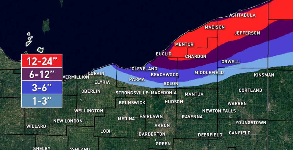
Aside from the clipper a week and a half ago, not much has gone great for us this winter (though many sites will finish December near or a bit above average snow for the month, so it's added up some). Was pretty disappointing to watch the models steadily trend farther NW with this system the last few days. The LES will be interesting. Should initially affect perhaps northern Erie County Monday afternoon/evening before winds come around a bit Monday night and Tuesday, pushing it into extreme NE Ohio. Winds come around to NW over water Tuesday night into Wednesday which should push the convergence south into much more of Cuyahoga and Geauga Counties into Wednesday night before inversions finally lower enough to kill the LES. I'm not sure bands will be persistent enough in any one area to get totals near what CLE has. Instability will be moderate to extreme through Wednesday evening. Moisture depth and equilibrium heights are OK but not great, however, winds will be fairly weak maximizing residence time over the lake, convergence will be strong near the shore, and BUFKIT shows the best moisture and lift centered in the snow growth zone for much of the event. This combination of parameters will support warning criteria where this band affects over the next few days. Think Erie County will see some 12"+ jackpots where the band persists the most, we'll see if it moves too much for more. Also think there's a good shot that Lake County, northern Geauga County, and parts of Ashtabula County see warning amounts Monday night through Tuesday evening. For Cuyahoga County (and possibly extreme NE Lorain County) and central/southern Geauga County, parameters support a decent band through Wednesday evening...still some time to figure if the and gets that far south, but if it does (which most indications currently suggest) parts of Cuyahoga County may see warning criteria amounts as well...eventually.
-
White Christmas looking pretty close to a lock in northern OH with two shots of potential synoptic snow this weekend. Not thrilled about the Saturday potential but think we could see a few inches Sunday evening.
-
We've gotten zero good events locally to show for it too, which is the worst. Still some juice though and the lake temps should level off over the next week.
-
Really odd setup from Friday afternoon through Saturday, but it could produce warning criteria snows over parts of far NE Ohio or Erie County PA (famous last words, lol). First, a surface trough moves through Friday afternoon. BUFKIT shows steep lapse rates and moisture to 7-8k feet and through the DGZ and a half decent vort max will accompany the surface trough, so a round of snow showers producing 0.5" to locally 1.5" of snow seems likely Friday afternoon/early evening. Then it gets odd. A wind shift will get hung up over the lake near the southern shore Friday night through Saturday. The isobar pattern becomes oriented W-E or WNW-ESE which suggests the convergence band will affect Erie County, especially near the lake, and perhaps get into northern Ashtabula and northeastern Lake Counties. Many of the 0z higher res models eventually get this into NE Ohio and possibly as far south as around 322 or so. I'm honestly skeptical of this...the low-level cold over Canada will be strong, which does suggest the front/convergence surging south...however, the air will be modified by lakes Huron and Erie, and will be fighting rising mid-level heights and a weak pressure gradient north of the boundary, both of which argue against the boundary surging that far south. The location of this boundary is important because Friday night into early Saturday lake effect conditions will be favorable with good moisture and instability to 8-10k feet, which along with a long fetch and good convergence will support a moderate to heavy band. Beginning late Friday night and through much of Saturday, mid-level isentropic lift (basically warm air advection) will occur over NE Ohio and NW PA, causing light synoptic snow to break out. Lake effect conditions dwindle Saturday morning and become pretty weak by Saturday afternoon as the warming mid-levels cause the inversions and instability to lower, but where this convergent lake effect band is seeded by the synoptic snow it will likely remain moderate to heavy into Saturday afternoon before weakening by early evening. All in all, the ingredients are in place for this lake enhanced band to produce heavy snow at times from Friday evening through early to mid Saturday afternoon, with some shots of lighter snow elsewhere. This band may not move a ton and could produce warning criteria snows. Given model biases to push these bands too far south and my concerns about a lack of "oomph" north of the boundary to push it and the band well inland, I suspect this will favor northeastern Ashtabula County and parts of Erie County (likely closer to the lake) for the best snow. Elsewhere there could be 1-3" type amounts from the off and on synoptic snow. This is a sensitive setup and may move around a lot, and it may be hard to get advisories or warnings out until Friday afternoon or evening...but will be interesting to see if it can play out somewhere.
-
5.9" from the clipper...not sure I'll tack on any more with the LES to give me a 6" total. Definitely not bad for a clipper! Have around 8" in the ground.
-
Yes. Pretty good shot of moderate to briefly heavy snow for a few hours should put down a few inches, and at the moment that still looks in line to hit us...though farther south towards Akron they may get a bit less. Then perhaps minor lake effect adds another inch or so. 4-6" should be a safe call, could see some 6-7" amounts downwind of the lake if everything goes perfectly (which, lately it hasn't).
-
I got another 0.2" this morning to push my "event total" to 3.1"...knock on wood but I should easily do better with the clipper. Will wait for all the reports, but it looks like Geauga County generally only saw 4-8" total, maybe locally more in the extreme north but not widespread. Cuyahoga County saw from an inch or two along the lake to 4-6" in far southern and also probably 4" or so in some of the hills east of 271. A nice portion of Medina and western Summit Counties did well with a nice area getting 4-7" there. In NW PA, it appears about the eastern 1/3 of inland Erie County and extreme NE Crawford County did manage storm totals of 8-14" give or take...Corry did get over a foot...but near I-79 and west as MAIDEsNOW can probably verify, it was very underwhelming. Must've just been too much dry air even there...really wish we had decent radar in NW PA to see these events play out.
-
It would be a rather spectacular and pretty inexplicable fail if you don't get at least a few inches at some point tonight and an event total of say at least 8". For NE OH this is always a possibility with NW flow events if there isn't a ton of moisture around, but NW PA usually does better especially with a fetch off of Lake Huron. Not the first time this has happened in the last couple of winters, so I'd probably be frustrated too.
-
That band in parts of Medina and western Summit Counties has been doing well. I'm really glad I put 4-8" in that area because some spots could see another 4" over the next several hours under that band. Elsewhere it's been lackluster. Other bands are finally intensifying...one into Lake and the NE 2/3rds of Geauga and northern Trumbull, and cloud tops have really cooled over eastern Ashtabula and Erie County PA over the last hour so I'm guessing it's finally snowing there too. Lake effect conditions peak over the next few hours and then slowly dwindle after midnight...so the bands should intensify a bit more and then slowly weaken after midnight. Winds move very little until 3-4am, so anyone under the bands could see another few inches (a 6" amount with the SWern band into Medina and western Summit wouldn't totally shock me, and NW PA in the higher terrain should do well too). Big holes between the bands seeing next to nothing through, including pretty much all of Cuyahoga County.
-
Like any good NW flow event, looks like most areas will struggle to hit the low end of the forecast. We will see where the lucky few bands set up this evening. Half decent one in parts of Medina and Summit right now.
-
2.6" here so far. Still snowing hard at the moment.
-
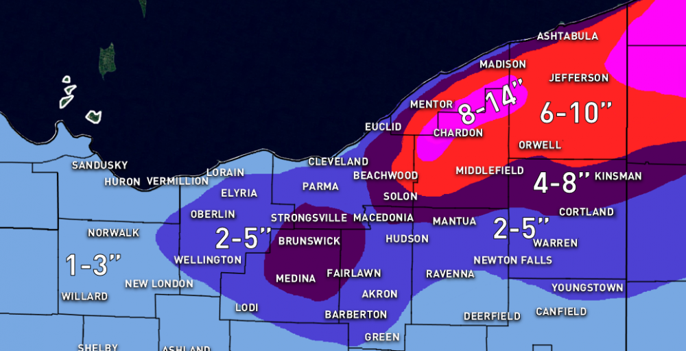
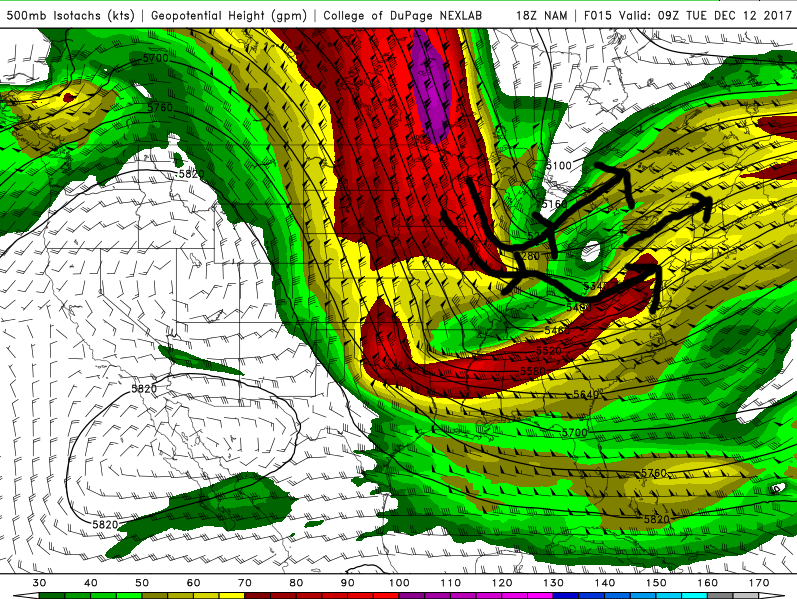
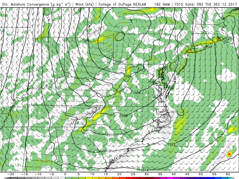
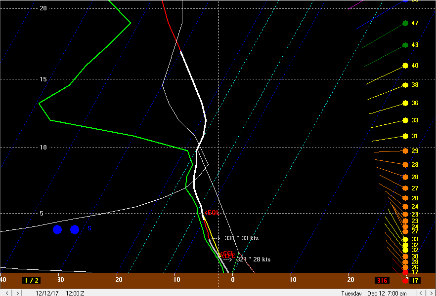
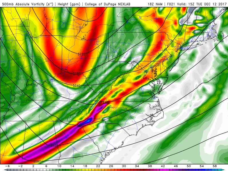
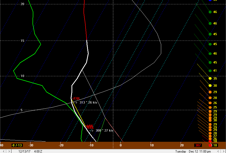
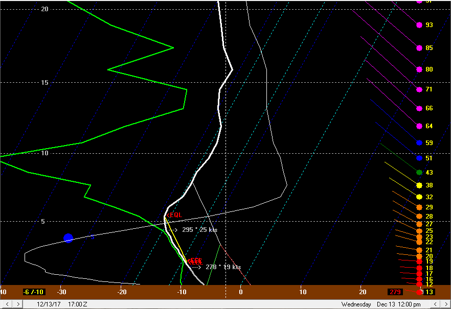
I'm a bit late getting my write-up done on this one...though I did beat the first flakes by a few hours. At this point I may get a map zoom that includes NW PA by the winter of 2019-20...my guess for NW PA is 6-10" near the lake including the city of Erie. 8-14" south of I-90 in Erie County and the northern 1/3 to 1/2 of Crawford County...and 12-18" in the southern half of Erie County mainly east of I-79 and perhaps clipping far northeast Crawford County. I just haven't had time to outline a new base map recently to include that area. Here's the map and write-up: I have a hunch we'll see a few narrow bands that are capable of producing the upper half of those ranges, and that 75% of the area will fall on the lower half of their respective accumulation range due to the short fetch and some drier air. Discussion: Current water vapor imagery shows a potent vort max over IL that will move roughly east tonight, causing a low pressure to deepen as it tracks over northern OH late tonight. On the backside of the low later tonight low-level convergence, deformation between the vort max and anther shortwave currently near Lake Superior dropping SSE, and lake enhancement processes will result in several hours of snow over north-central and northeast Ohio. The deformation can be seen very nicely on the 500mb wind plots on the models, and the heart of it moves right over northern Ohio and Lake Erie between 6z and 12z tonight-Tuesday morning. This will drive light to perhaps briefly moderate synoptic snow across the lake and northern Ohio later tonight into early Tuesday. As the low passes to our east, winds will flip around to the NW after 3-4am Tuesday. There will be some increase in convergence with the wind shift, and also an increase in shoreline convergence downwind of Lake Erie and upslope in the higher terrain. This may result in a brief burst of better moderate snow with the wind shift itself followed by moderate snow continuing just downwind of the lake in the higher terrain due to convergence along the shoreline and upslope. Due to temps near freezing the snow will be on the wetter/low ratio side initially, though ratios will quickly go up Tuesday morning as colder air pours in. The deformation zone begins pulling away to the east by around 12z/7am Tuesday, which will cause the organized light to moderate synoptic snow to diminish from west to east to start the day Tuesday. While this occurs, instability will really improve downwind of the lake, which along with any lingering synoptic moisture should keep decent snow going mainly in the higher terrain. The snow will likely be rather disorganized due to some shear and a short fetch across the lake, but should keep going. A lowering DGZ should result in ratios beginning to improve as well. Although the deformation and organized synoptic snow should start pulling away around 12z Tuesday, a potent shortwave will cross. PVA/lift ahead of the shortwave, along with favorable moisture and instability profiles below 10k feet, should keep snow showers going downwind of the lake, particularly in the higher terrain. 700mb RH remains high until the crossing of this shortwave, and I think that moisture and lift will be enough to keep decent snows going in orographic lift ahead of this shortwave. With steepening low-level lapse rates, some briefly squally snow showers could also occur outside of any lake effect with this feature. After the shortwave passage late morning, moisture strips away both at the surface and aloft, which along with the brief period of sinking motion behind the shortwave should result in the snow being disrupted for a few hours. By later in the afternoon the winds become very well aligned out of the NW and instability becomes extreme, with equilibrium levels of near 11-12k feet and good moisture to about 7k feet. This should result in lake effect improving, however, the fetch is on the shorter side and wind speeds in the mixed layer are greater than 30 knots, making it questionable how widespread the lake effect will initially be. With some drier air and a shorter fetch/stronger winds, upstream connections may be critical to where moderate to heavy bands can develop Tuesday afternoon/evening. There will be a few corridors to watch: 1) Off of southern Lake Michigan into western OH…won’t do anything for Lake Erie, but will bring swaths of light accumulation to parts of western OH. 2) From near Traverse City to southwestern Lake Erie. This connection could be interesting, as the wind direction of around 300 degrees will favor convergence near the southern shore in the western basin…this connection and local convergence could allow a half decent band to form for a time from Huron County into southern Lorain County and parts of Medina/Summit Counties. 3) A potential minor connection with western Lake Huron/Lake St. Clair into the higher terrain of the primary Snowbelt. 4) A likely connection from Lake Huron into NW PA. Outside of any connections there will probably be some sizeable breaks in the snow late Tuesday afternoon and evening. There may be one last shot of synoptic moisture/lift Tuesday night, which could potentially result in a significant uptick in snow, but this may stay just east of most of NE Ohio. The models all show a vort max dropping south on the west side of the larger low to our east Tuesday night. The NAM (above) shows the better lift and moisture just grazing NE Ohio, likely resulting in some increase in activity, especially from Geauga County points east and definitely in NW PA, but probably keeping the heavier activity limited to a few bands. The GFS is a good 50-75 miles farther SW with the vort max and increased synoptic moisture/lift, and would likely result in a significant increase in activity in the Cleveland metro and secondary Snowbelt as well. The Euro is closer to the GFS, but perhaps not as extreme with how much RH it shows at 700mb. Regardless of the vort max, some PVA with the back wall of the trough later Wednesday night may also result in some increase in activity. The thermodynamic profile is quite good Tuesday night for lake effect snow, with equilibrium levels remaining above 10k feet to go along with lake to 850mb and lake to 700mb temp differentials of near 25C and 32-34C respectively, giving extreme instability. Winds also become well-aligned, and the wind speeds in the mixed layer decrease a bit (but still remain stronger than preferable given the shorter fetch). If we see a NAM-like scenario play out with the better synoptic moisture/lift not hitting NE Ohio well, we’ll likely see a few organized and intense bands play out, but with significant breaks between the bands. NW PA looks to do really well either way, especially where the Lake Huron connection comes in. If we see better synoptic moisture/lift into NE Ohio, then a more general moderate to heavy snow may break out for a few hours in the higher terrain, with any bands intensifying. Either way, the synoptic support diminishes later Tuesday night and moisture aloft does start stripping away, so we’ll likely go back to a more localized multi-banded setup later Tuesday night even if we do see a more significant uptick in the evening. Wednesday morning should feature just a few remnant multi-bands as we lose the synoptic support, moisture strips away above 5k feet, and inversion heights fall. There may be enough juice for a transient west to east band to flare-up later Wednesday morning and afternoon from Cuyahoga County points east/northeast as the winds back. With moisture below 5k feet and lift/steep lapse rates through the DGZ, along with a better fetch, this band could produce some additional accumulations. Seeding from mid-level moisture will also help potentially produce some accumulating snow with this band Wednesday afternoon. Winds will be backing pretty quickly and will be SW by late afternoon, likely pushing the band over the lake by late afternoon/early evening and keeping it from dumping on any one area before then, but this could lead to one last gasp of accumulations for some areas in the primary Snowbelt. AS FOR AMOUNTS… The synoptic snow should produce a general 1-3” for much of north-central and northeastern Ohio, even outside of any lake effect areas and along the lakeshore. In the higher terrain of the secondary and especially primary Snowbelt where lake enhancement/orographic lift will augment the synoptic snow, there could be a good period from about 2am to 10 or 11am of decent snows with improving ratios after sunrise. This could result in a general 3-6” in the higher terrain by noon Tuesday in NE OH/NW PA (secondary Snowbelt will see the lower end of that). As lake effect gets better organized Tuesday afternoon, will likely see corridors of 1 to locally 3” of additional snow through the afternoon from potentially Huron/southern Lorain and parts of Medina/Summit Counties points northeast. I think the best chance for 3” will be in the higher terrain of NW PA, most should see less during the afternoon…I just think the bands will be too localized for widespread heavier amounts during just the afternoon. During the night we’ll likely see at least a few bands with heavy snow persist most of the night. The area closest to a slam dunk for heavy accumulations overnight will be the higher terrain of NW PA due to a very high likelihood of synoptic enhancement to the snow and a Lake Huron connection, along with a longer fetch over Lake Erie and more terrain to wring out the moisture. In NE Ohio I think given the tremendous instability and well-aligned winds that two or three more intense bands will setup and may drop up to a few inches, even if we don’t get the better synoptic moisture and lift. If we don’t see the synoptic assist, totals in NE Ohio will likely vary from 1 to locally 4” additional overnight…locally could see more, but it would be very localized and is hard to pin down ahead of time. If there’s better synoptic support over NE Ohio as well, which the GFS and Euro do currently show, then a widespread 2-4” in the higher terrain with amounts of potentially over 6” in better bands would be on the table. For now my forecast will be a compromise solution with a general 2 to locally 5” overnight in the higher terrain of the NE Ohio Snowbelt, including potentially a band well SW of Cleveland as discussed above, with less than 2” along the shore. Will go for a general 3-7” in the higher terrain of inland Erie County and northern Crawford County PA overnight Tuesday night, but a locally higher amount is quite possible if a more dominant Lake Huron connection sets up for a length of time. On Wednesday have to think any band would be transient enough that additional amounts will struggle to exceed 1-3” anywhere. Will anticipate light additional amounts from the potential band in northern and eastern Cuyahoga County, Lake County, Geauga County, Ashtabula County, and perhaps Erie County PA. For storm totals…highest will be in NW PA, where I’m coming up with around 9-19” (will go with 12-18”). In the higher terrain in northern Geauga and inland Ashtabula County, I’m coming up with around 7-17 (will go with 8-14”). The higher terrain south of CLE in the secondary Snowbelt I’m coming up with 5-12”…I highly doubt the 12”, as the higher ends of each period after the synoptic snow are due to a potential localized heavier band, so I’ll call that area 4-8”. The NAM has that SWern band setting up from central Medina County into northern Wayne County towards Stark County for quite a while…think that is a little too far SW, but it’s not unheard of for a band in this type of flow to work it’s way down towards CAK in southern Summit County, so I will show somewhat heavier amounts in that area to account for the possibility. Will show just 1-3”/2-5” amounts along the shore in Lorain/Cuyahoga/Lake Counties, but bump up some farther NE where there’ll be better synoptic support during the lake effect. Will show amounts increasing in the higher terrain in southern and eastern Cuyahoga County due to better orographic lift. Could see a 10” amount in extreme east-central Cuyahoga County if banding can set up over that area for any length of time at some point.
-
Has been disappointing watching trends for this weekend. Conditions become reasonably favorable for LES Saturday night, but it's a brief window and winds will be shifting. Someone could see 2 or 3" in the Snowbelt, most will see less. Hopefully the Monday-Wednesday clipper + LES threat is more bustproof.