OHweather
-
Posts
5,046 -
Joined
-
Last visited
Content Type
Profiles
Blogs
Forums
American Weather
Media Demo
Store
Gallery
Everything posted by OHweather
-
No radar coverage certainly doesn't help you. Should be impressive totals near the shoreline though.
-
Next weekend could be interesting, but it's still 8 days out. Can't ignore a 1050mb high just to our north if you can throw a lot of moisture up our way. I'm more worried about not getting the moisture far enough north than not being cold enough at this point, so it'll probably just rain There's still enough heat flux through thinner ice that with some above freezing temps/rain/wind this week that we'll still probably get some juice from the western basin when it gets cold again...but yeah, for some spots this has been a very frustrating LES season. Some areas have done very well, but some big "losers" as well.
-
The flow is too weak for locations well inland yes. 3SW Willoughby had 7" as of 5am and Euclid got 4" between 7pm and 11pm...so that narrow corridor did well. Everywhere else the band moved a bit too much and kept amounts to 2-3" it looks like. Parts of Erie County in NW PA saw upwards of a foot overnight.
-
Lol, the models are now bringing another surface trough through Saturday morning and turning the winds WNW instead of letting a high build in. I can't imagine the snow being extremely intense by then, but maybe it sneaks far enough SW for Trent to pick up a couple of inches. Us inland folk may never do great with such light winds. Arctic front moves through Saturday night probably with another burst of snow that could be a couple or few inches. It'll all add up a little bit.
-
Coming up on two inches here as well. All things considered not a bad total.
-
Today will put me over 20" so I still like my chances. Average out my way is probably 70-75", which will be tough. 50" not as hard.
-
These little bursts don't last long but they're certainly nice. I've gotten so used to SE Ohio that a 50" winter would knock my socks off at this point but a good spread the wealth event or storm would be nice at some point
-
Between the snow today and the little burst of les tonight with the wind shift you guys should get like 2"...but yeah the best will again be farther north.
-
I don't have time to put together a write up, but here are some quick thoughts for Thursday evening-Saturday morning. This map only includes snow from 7pm Thursday on and does not include anything falling before then, including the LES or light clipper snow. A established and heavy band of snow should push off the lake mid to late Thursday evening into the primary snowbelt in NE OH and NW PA as a surface trough/wind shift pushes south. Thinking is we get a WNW flow Thursday night behind the clipper which initially sets a band up in northern/eastern Cuyahoga into central Geauga before the winds go W to WSW Friday morning and push things into Lake/maybe extreme northern Geauga. We get another little shortwave Friday evening that may push things back south a bit (after perhaps a break for most everyone briefly Friday afternoon) and re-intensify the band for a time, before things end by early Saturday. Snow showers may linger a few hours longer in NW PA on Saturday until the winds go due SW by noon. Instability is moderate and moisture is OK but not great. There could be some Lake MI help. Winds look light, generally 15MPH or less, which favors better banding and keeps the heaviest closer to the lake. Ratios will be high so accumulations could be quick. Banding moves some but may lock in for several hours Friday morning into the afternoon on a flow that generally favors Lake County. With some accumulating snow lingering through Friday night this turns into a fairly long duration event, and I'd be shocked if favored areas didn't see over 6". Parameters don't support super heavy 2-4" per hour rates, but any band could easily produce an inch an hour through Friday afternoon before conditions diminish further Friday evening into Friday night. Right now I favor NE OH for a little more snow than NW PA for this leg of the event because of the surface trough pushing south into extreme NE OH and trying to focus the heaviest snow there. The W flow favors better shoreline convergence in NE OH as well. Tough call for Cuyahoga. Flow doesn't really have any northerly component by 7AM Friday on the models and is light, so any snow by that point would affect Euclid at most and that's about it. With a light WNW flow Thursday night into very early Friday, convergence may sit over northern Cuyahoga and could drop accumulating snow even as far west as the western lakeshore before it shifts north Friday morning...amounts could be higher near the lake farther west, but I'm not extremely confident in that yet.

-
They probably need a warning for Erie County...you can tell on radar and satellite that things organize as you head through eastern Ashtabula Co into NW PA...pretty typical for a strong due W to WSW flow. Things will shift out over the lake during the day Thursday, but Thursday night through Saturday AM will be interesting at times. The best banding may be in NE OH Thursday night into Friday morning, but Erie County should get some more chances Friday and Friday night.
-
Someone in Lake or Ashtabula could sneak in 4"...the snow isn't that organized but the heavier bursts keep training over the same areas so it may add up some. Pretty favorable conditions for a band to develop late tomorrow night into Friday with a light W wind and moderate instability...NAM and GFS have a W to WNW flow for several hours before backing later Friday morning, Euro doesn't ever develop a northerly component. I think there will be warning amounts tomorrow night into Friday but it'll be interesting to see if that band can get into northern Cuyahoga or Geauga before it shifts north. Wind direction will be important.
-
Best shot will be Thursday night into Friday when the winds try to gain a bit of a northerly component...it's possible.
-
We warm back up again next week so we should still have an open western basin the next time it gets cold. This winter has been a great example of cold/dry and warm/wet so far. We had a fairly close to average December in the temps/precip department but the snow just didn't work out outside of the LES jackpot areas. Still a ton of time left for snow.
-
Definitely a good month for those who cashed in on the LES. Frustrating for those who just missed it! I'm at 19.3" on the season (with 17.7" of that coming in December). Those numbers are both below normal, but after being in Athens for the meat of the last 3 winters (and part of the 12-13 winter, although I was here for the decent December stretch in 2012) it seems like enough snow to go around.
-
What really surprised me and killed totals was the lack of good upslope snow developing. The lack of organized bands was expected, but upslope was expected to offset that in the higher terrain. Higher totals being well inland normally is a symptom of the wind being too strong, but we've gotten decent upslope snow with stronger winds. Another issue I noticed was T/Dew spreads were a few degrees larger than modeled resulting in lower RH values and higher cloud bases. That may be why upslope never really got going, which did kill totals in some areas. 3 events this year where things have just been a little off and really hurt totals.
-
That honestly shocks me. Radar and satellite looked good in NW PA last night although with the radar beam being so high there it's hard to tell. I can't think of a good reason for why the higher terrain there didn't do at least half decently. But it happens I guess. The lakeshore busts pretty often everywhere because it's hard to get big events there, so I'm sure CLE over warns there. You seem to normally do ok at least inland, although this event really didn't pan out.
-
I definitely agree with most of that. I was surprised at the 2" per hour thundersnow last evening, but that was sort of the dagger after they didn't issue the advisory. I'm not sure if there's a way to fix it other than common sense when deciding whether or not to issue headlines. Some events that end up being upgraded mid-way through are truly surprises, and there's nothing that can be done about that, but getting in a habit in borderline situations of not issuing anything until it's abundantly clear it'll verify isn't good IMO. I'd rather issue and miss than not issue and get hit big. The public wants simplicity, but I'm not sure how much simpler the headline system can get...you have headlines for synoptic snow, lake effect snow, ice, and cold...that's it. I know that public doesn't know the differences between a watch, an advisory, and a warning, but that's on the public and only on the public for not caring to know. The names of the headlines tell you what they imply, and it's not like mets haven't tried explaining it a million times. It sounds like the NWS is trying to get rid of LES and ice headlines, so you'd just be left with winter weather advisories/winter storm warnings and the wind chill stuff. We'll see if that makes any difference to the public. I'm sure all of a sudden people will be confused when what was a lake effect snow warning is now a winter storm warning when they didn't pay attention to them now. I'm curious to see the totals. They're going to be on the low end across the board again because nothing was organized last night. It was all moderate to heavy stuff but it just kept moving.
-
I wasn't home for the band, but there's about 3" here. Again, great call by CLE not including any of Cuyahoga County or the secondary Snowbelt in the advisory. That 2" per hour snow is no big deal, and it won't snow any more overnight into tomorrow. It looks like just a little wind shift from WSW to W was enough to cause that band to pop...the low levels must be pretty juiced because temps on land were not really much colder than the water temps, so although I'm sure some frictional convergence along the shore was responsible for focusing the band and slowing it down where it did, the lake didn't add a ton of juice to that. Upslope snow has started increasing in Geagua and Portage Counties with a nice blob southwest of Cleveland as well. The Chardon cam shows pretty decent snow right now. Snow showers from Lake MI have made it to the western basin, which will likely cause snow coverage to increase again by 11pm to midnight in NE OH. Mid-level temps also cool a few more degrees over the next several hours which will increase lake induced instability more. The next shortwave/vort max appears on track for late tonight into early Friday morning, which should again cause an area-wide uptick in snow. There will be a wind shift from W to WNW with that shortwave, which may try to set off another band. We'll see. Overall the forecast still largely looks on track. The one downfall here is that the lakeshore will continue to largely struggle, but with some Lake Michigan bands making it in and another trough later perhaps they get a bit more.
-
Radar lighting up fast...should be a good night of snow.
-
Not in agreement with CLE leaving Cuyahoga, Summit and Portage out of the advisory, especially with a decent impact to the Friday morning commute. We will see how things go tonight...radar pretty lit up near Grand Rapids, so hopefully that's a sign of what's to come.
-
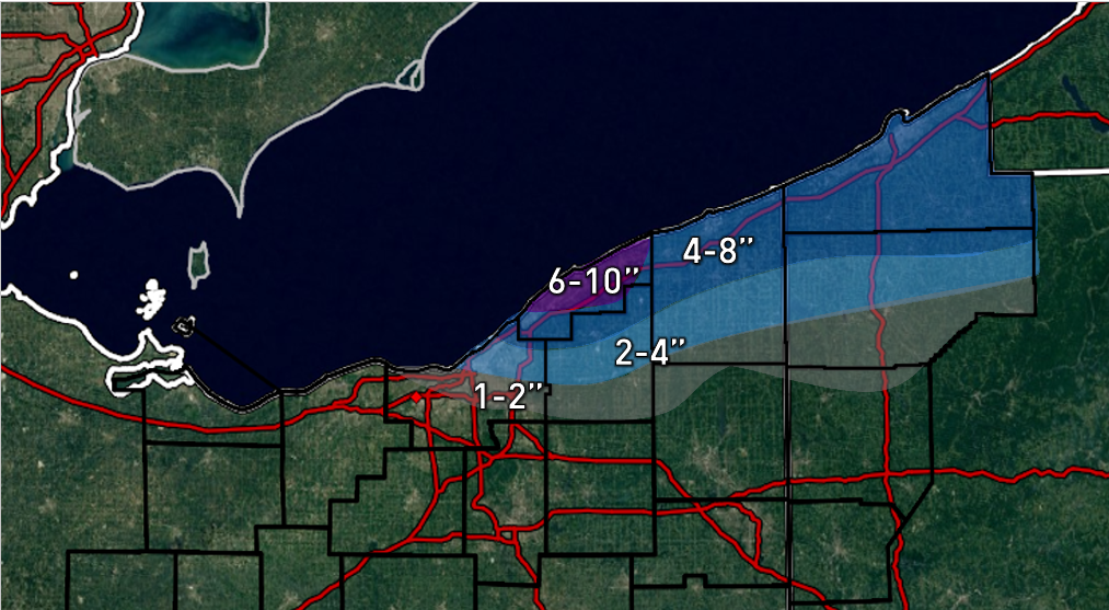
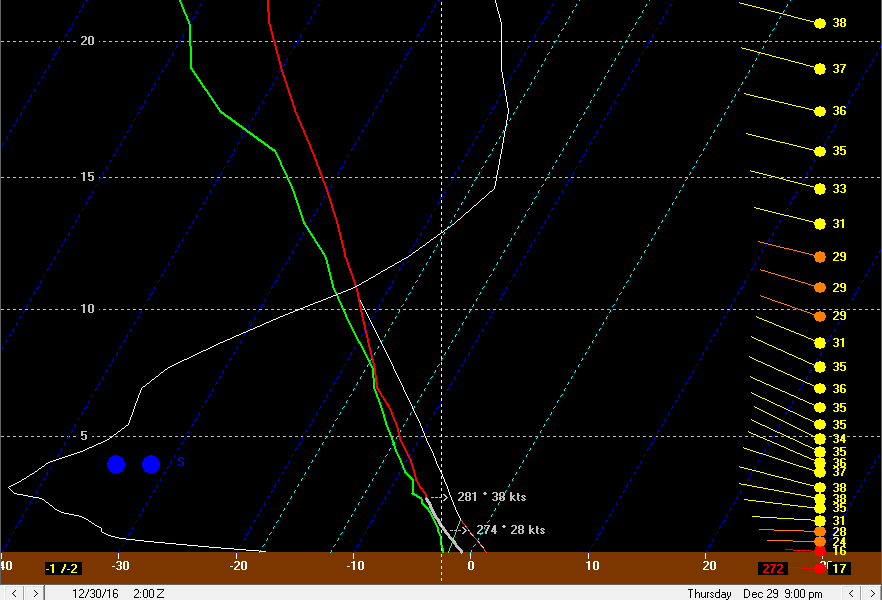
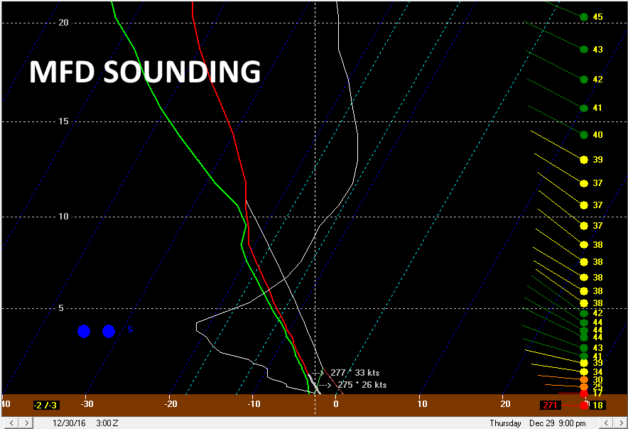
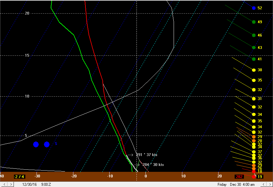
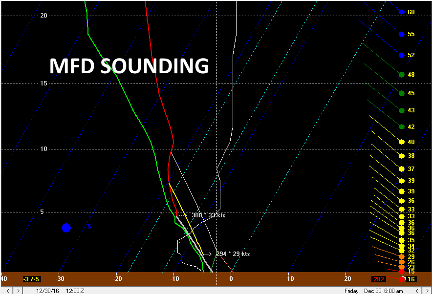
Here's my map: Discussion: A fairly deep upper level trough will take on a negative tilt over the eastern Great Lakes and New England Thursday night into Friday, allowing a low pressure to bomb out over eastern New England. This whole process will allow cool air to move across the Great Lakes, and keep a rather deep and moist cyclonic flow going over the Great Lakes through Friday. Although the airmass won’t be extremely cold and the lakes aren’t running as warm as previous lake effect events, the abundant moisture should allow some decent snowfall to occur downwind of the Great Lakes to end the week. A little vort max may graze extreme NE OH mid Thursday afternoon…lake to 850mb temp differentials of only 11-12C and instability/moisture extending to only 4-5k feet will limit how much snow can get going Thursday afternoon. I could see a few flurries in the primary Snowbelt Thursday afternoon, but not much more. Pictured above is a first vort max starting to rotate into northern Ohio Thursday evening, adding better large scale ascent. In addition, moisture depth will increase to over 10k feet quickly Thursday evening with the arrival of this vort max while instability also increases and deepens. Forecast soundings show this improved thermodynamic environment quickly developing by mid Thursday evening over Lake Erie: Note that the instability, while not extreme, extends to around 10k feet, with plenty of moisture past 10k feet as well. There is upward motion (the white line) extending through all of the dendritic growth zone on the soundings Thursday evening, so once temperatures fall a couple of degrees below freezing snow to liquid ratios should improve. The flow on this sounding is a bit strong in the lowest 10k feet, with a deep layer of 30-40 knot winds, and there is a bit of shear. This will likely prohibit a strong single band from forming; however, large scale lift from the vort max, some moisture from southern Lake Michigan, a deep layer of moisture and instability and an OK flow for upslope to start developing should allow moderate to locally heavy snow to quickly develop Thursday evening as the first vort max moves in and allows conditions to become more favorable for snow. The low level flow will be in the 270-280 degree neighborhood Thursday evening, which does favor the bulk of the Lake Erie moisture affecting northern Geauga County east, and this is where the heaviest snow will likely take place Thursday evening…particularly in NW PA where there’s a longer fetch over warmer waters and more terrain to really enhance the orographic lift. With that said, the low level flow will still carry Lake Michigan moisture into the west side and Cleveland metro Thursday evening, so this combined with the abundant synoptic moisture and some lift will likely allow snow showers to develop over the secondary Snowbelt Thursday evening as well…it may not be quite as heavy due to less help from Lake Erie, but this isn’t a pure lake effect situation where you’re often dry outside of the main bands. The cold air advection regime allows a deep layer of conditionally unstable lapse rates to develop, which when combined with abundant moisture from the trough itself and Lake Michigan will allow half decent snow to develop south of the best Lake Erie enhancement…particularly in the higher terrain where upslope will occur. Although the flow doesn’t quite bring Lake Michigan moisture down into the central highlands Thursday evening, the ambient low level moisture combined with a deep layer of conditionally unstable lapse rates is still expected to develop…this, combined with modest upward motion with the vort max and upslope should allow light to moderate snow to develop over the central highlands Thursday evening as well. The surface winds don’t quite hit the axis of the highest terrain at 90 degrees, but it should still be enough to get snow going. The best upward motion here is located below the DGZ on this sounding, but the steep lapse rates and moisture do extend through the DGZ, so the weak convective processes could occur through the DGZ and allow for fairly high ratios in any upslope in the central highlands by mid to late Thursday evening. The snow may abate a little bit for a brief time between 1am and 4am Friday as we get a weak period of sinking air behind the first vort max. Lake effect conditions continue to slowly improve so that may offset the weak larger scale descent…I doubt the snow stops but it may briefly lessen in intensity. This potential lull will be short lived as a more potent vort max approaches and provides for another period of some large scale ascent between 4am and 10am Friday. Lake effect parameters remain largely decent as this second vort max drops in, with instability and moisture still extending to over 10k feet. The wind speed and shear are still a bit strong which will likely prohibit a very intense band from forming, however the synoptic moisture/lift and decent enhancement from the lake will still likely result in moderate to heavy snow, particularly in the higher terrain. The winds do gain a more NWrly component early Friday morning as a surface trough pushes through, which will likely allow the “heaviest” snow to expand into Cuyahoga County and likely parts of the surrounding secondary Snowbelt as well, as the best Lake Erie enhancement shifts south. There may not be a sharp surface trough early Friday with the wind shift, and instead a more gradual shift. There may be a brief increase in convergence as the winds shift, but I doubt a big band will develop and swing south. Regardless, the favorable conditions for enhancement and upslope suggest good snows will continue into Friday morning, especially in the higher terrain of the primary and secondary Snowbelt. With the winds gaining a more northerly component early Friday morning, the connection should shift south of the lakeshore and Cleveland metro and hit the central highlands. Because this is occurring during a period of enhanced large scale ascent from the vort max, and because there’s not only a Lake Michigan connection but also the low level winds hitting the axis of the higher terrain at nearly a 90 degree angle, there’s definitely a risk for some pretty good snows for a few hours in the central highlands Friday morning. Forecast soundings from MFD for early Friday still show moisture and CAPE through the entire DGZ, with the flow hitting the terrain at nearly a right angle. When factoring in the modest lift with the vort max and a likely Lake Michigan fetch, the conditions do appear ripe for another decent period of snows in the central highlands wherever the Michigan fetch sets up Friday morning. Decent snow showers could continue well east across the rough terrain south of route 30 and produce up to an inch or two in spots, making for a rough Friday morning commute in locations well outside of the normal Snowbelt. Synoptic lift goes away and moisture depth decreases Friday afternoon as the trough pushes east. Lake effect conditions remain OK downwind of Lake Erie, so with a WNW wind some snow showers will likely continue across the Cleveland metro and primary Snowbelt…but nothing extreme. Winds turn W and then SW Friday night, but with inversion heights crashing I highly doubt there’s much if any attempt at activity re-organizing on the west flow Friday evening. A note about the hi-res models…there is no ice cover over western Lake Erie except for near the Canadian shoreline, and even there it’s slushy. The hi-res models show a little bit of clearing and radiational cooling over the ice Thursday night into Friday morning. Satellite imagery showed that there isn’t ice here (and even so there is still some moisture and heat flux through ice), so these models likely are erroneously light on snow amounts from Cuyahoga County southwest into Lorain and Medina Counties due to incorrectly shaving like 60 miles off the fetch and then making that air colder than the air over the surrounding land. As for amounts…the heaviest will likely be in the higher terrain. Because of a longer fetch and longer duration of flow off of Lake Erie, the primary Snowbelt higher terrain should see more snow than the secondary Snowbelt. NW PA should see more than the NE OH Snowbelt due to a longer fetch and even higher terrain yet. Given the duration of heavier snow in NW PA (a good 18 hours), I still expect max amounts to exceed a foot there in the higher terrain. In Geauga and Ashtabula Counties (particularly the higher elevations in northern Geauga County), I figure max potential amounts are probably in the 10-12” range…with widespread amounts of over half a foot given the duration of decent snows and what should be 15:1 ratios or so. The fetch off of Lake Erie doesn’t quite go into the higher terrain in eastern Cuyahoga initially and takes a bit longer yet to hit the higher terrain in the secondary Snowbelt, and the fetch for these areas is over waters that are a few degrees colder, so rates may take longer to get moderate to heavy and probably won’t max out quite as heavy as farther east. Even still, a good 12 hour or so period of decent snows could yield max amounts of 6 to 7” or so in the secondary Snowbelt, with widespread amounts of at least 4”. Given some upslope starting Thursday evening and a likely Lake Michigan connection late Thursday night into Friday morning for at least a few hours, I do think the higher terrain all the way down to Mansfield and maybe even into northern Morrow County could see a few inches in spots. I painted in 2-4” here for now, although there could be locally a bit more if the Lake Michigan connection sets up over a certain area and doesn’t move a ton. With continually shifting winds, the latter scenario doesn’t seem particularly likely. With a WNW flow for a while late Thursday night into Friday morning, we’ll have to watch for a shore parallel band developing and moving into the secondary Snowbelt in Lorain, Medina, and Summit Counties. Winds are still a little on the strong side with a bit of shear during this timeframe, and as I mentioned I doubt a big band swings into these counties from the north as the winds shift, so I’m leaning against this scenario…but if it did occur, local amounts may exceed my 6-7” max in the higher terrain of these counties. The lakeshore is tough, especially from Lake County on west. I went 1-2” for these areas. With the expected lack of big bands, I think you’ll need some terrain to get decent snows. With that said, sometimes WNW flow lake enhanced events feature frictional convergence over Lorain and Cuyahoga Counties that can intensify snow in these areas, so I’m not entirely sold that some of the lower elevations in the northern portions of those counties can’t get 3” or so…but the highest amounts will certainly be confined to the higher terrain farther south and east. With that last bit said, I did put most of Cuyahoga into at least 2-4” outside of the immediate lakeshore.
-
I think the hi res models may be underdoing amounts on the western end of things, because the temperature fields on them clearly show colder temps over western Lake Erie than over the adjacent land. That is wrong and can only be a good thing for us. The hi-res models are trending beefier tonight. Maybe we can sneak in a couple inches of paste.
-
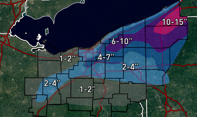
The snow event Thursday afternoon through Friday continues to look interesting...could be an inch of wet snow very early Thursday with the cold front, especially on the east side as the moisture will just be sliding in as the front moves through northern Ohio. After that, a prolonged lake enhanced event starts up Thursday afternoon through Friday morning, with some light lingering lake effect Friday afternoon into Friday night. With a WNW flow, good synoptic moisture, a Lake Michigan connection at times, a deep layer of instability, and multiple vort maxes (I count 3 on the models from Thursday afternoon through Friday morning) dropping through, the higher terrain could see a prolonged period of moderate to heavy snow Thursday afternoon through Friday morning. Lake Michigan moisture and a favorable WNW flow for upslope could even bring 2-4" type snows into the higher terrain of the central highlands near Mansfield. Still some time to iron out the specifics, but I'm thinking 4-8" for the higher terrain of the primary Snowbelt and 3-6" for the higher terrain of the secondary Snowbelt from Thursday afternoon through Friday morning, with perhaps another inch or so here and there with the lingering lake effect after that time. The lakeshore will likely struggle a bit more, but should at least cover the ground. I'll probably post a forecast Wednesday night, but this could be a widespread advisory event at least for the primary and secondary belts...with maybe some warning amounts in parts of Geauga County. With a longer fetch over warmer water and more terrain in NW PA, the higher terrain there could see local amounts of over a foot.
-
Snow in the Cleveland area (outside of the snowbelt especially) really is such a conundrum. We really are in a poor spot for big synoptic snowstorms...lows are favored to develop over the Plains, and those often cut to our northwest and bring warmth or shear out/weaken before they get here. Lows are also favored to form over the Gulf Coast (which is where some of our largest snowstorms have come from), but those often go to our east. Lows are also favored to develop off the East Coast, which is almost never good for us. We need to hope for a low that either doesn't blow up too quickly to our west, or a Gulf low that manages to track more north-northeast and doesn't miss us to the east for a huge snow. It can and has happened, but it's not necessarily easy. Our bread and butter is definitely numerous light to occasionally moderate synoptic snow, with a good bit of lake effect mixed in. Despite the negatives I mentioned above, when we lock into an active pattern with frequent small systems and lake enhancement/lake effect with them or behind them, it can add up quickly, even without a huge foot plus synoptic snow storm. We have seen two pretty good LES events so far this winter, but one completely missed CLE and one just missed CLE with the jackpot. Otherwise, we haven't been locked into a great pattern snow yet, so it's all been about whether or not a spot has cashed in on LES or not. Last winter was a complete turd and I don't wish to attempt to polish that at all, lol. 2013-14 and 14-15 definitely had their highlights at times...14-15 had a very good string of LES events in November that did affect the Cleveland area well...and what is probably one of the most intense stretches of winter (between above normal snow and bitter cold) we've seen in our lifetimes from mid-January through the first few days of March. We did mix in a synoptic storm on Superbowl Sunday that winter that did drop a widespread 8-12" on the lakeshore counties, although I can't remember if they managed to properly measure that one at the airport or not. That storm looked like a bust last second but ended up panning out, which may cloud people's memories of it...it was 10" of cement that froze over the next day and was definitely a decent storm. The downfall of that winter was that December and March...typically months that can be quite productive (especially December)...were both almost snowless, so we finished the winter a little bit below average, but definitely had some very good stretches along with one pretty big storm. 13-14 didn't have a huge synoptic storm, but had numerous light to moderate events, enough to push CLE to over 80". We did not do as well as TOL and DET, and even CMH compared to normal, so I guess we were in a local screw-hole, but that probably just comes from bad luck more than anything else. It's also worth noting that some of the storms in the TOL and DET area in the 13-14 and 14-15 winters were pretty high end for them in terms of big storms, and that the big storm that crushed the eastern OV (mainly WV) last winter was also pretty high end for that area as well...so it's not like you'd expect a repeat of those types of storms nearby every winter, but I'd think we're due for a nice warning criteria synoptic snowfall on the order of 6 to 10" soon. At least I hope!
-
It was questionable whether or not the ground was still 50% covered or not here today...marginal white Christmas at best down here...it'll be a moot point tomorrow with temps in the 60s. It will be interesting to see if the heart of the Snowbelt can hang on to some snow cover since the warm up will be relatively brief. The lake effect Thursday night into Friday could be OK...instability won't be extreme, but there will be good moisture and a WNW fetch with little shear, so it could be an OK event...maybe enough for some advisories.