

OHweather
-
Posts
5,046 -
Joined
-
Last visited
Content Type
Profiles
Blogs
Forums
American Weather
Media Demo
Store
Gallery
Everything posted by OHweather
-
Good bursts sticking almost immediately with this band.
-
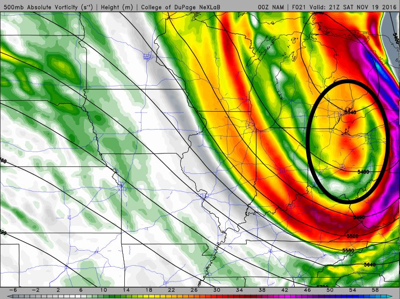
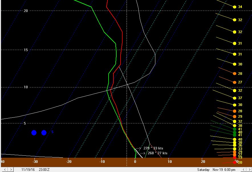
It’s a beautiful site! After being transplanted to a Virginia-like climate for the last 12 or 13 months, the models have a closed low just to our northeast Saturday night, with plenty of cold air and synoptic moisture moving over the unseasonably warm waters of Lake Erie. Finally, the wait is over and our first true taste of winter is here! A band of ana-frontal/post-frontal rain will not clear eastern OH until late Saturday morning/around noon near the PA boarder. 925mb temps will crash to 0 to -2C by 13-14z/8-9AM, with surface temps in the upper 30s to near 40. These low level temp profile will be marginally supportive for some flakes mixing in on the back edge of the ana-frontal rain band. So, this basically means that we’ll start our Saturday on a positive note, assuming you like mangled snowflakes mixing in for 20 minutes with gusty winds and falling temperatures as much as I do. It doesn’t mean much more, because the precip will briefly pull out of the area before anything more interesting happens. Interesting weather returns late Saturday afternoon/early evening as a vort max rotates across northern Ohio and Lake Erie. This vort max will move in on the leading edge of wrap around moisture, and also be accompanied by a surface trough/wind shift that will drop southeast across the lake. Oh, this is exciting already! Here is the surface map, showing a noticeable kink in the isobars and shift in the winds. The winds ahead of the trough over NE OH/NW PA are WSW, with winds behind the trough out of the WNW. These are fun wind directions, because it gives a long fetch for the trough to work with over Lake Erie, and also brings pre-seeding from southern Lake Michigan. The thermodynamic environment as this trough pushes across the lake will become extremely favorable: Deep moisture to nearly 20k feet, over 700 J/KG of lake induced CAPE, with equilibrium levels near 13K feet, along with the convergence with the trough and likely pre-seeding from Lake Michigan will combine to generate intense precipitation along the wind shift as it pushes off of Lake Erie. A band may briefly form over the lake parallel to the shore in the WSW flow ahead of the trough and swing inland. 925mb temperatures of -2 to -3C and 850mb temperatures of around -8C as the trough pushes inland will easily support all snow (or perhaps graupel) with any decent bursts of precipitation. Inland it probably won’t take much of a burst to fall as graupel or snow, as these temperatures are a couple of degrees C colder than what it normally takes to get early-season accumulating lake effect snow. The trough pushes south fairly quickly, however many areas will likely see a quick burst of snow. Given the likelihood of intense precipitation along this trough, some areas could see a quick half inch or inch of snow as the trough pushes inland…even the lakeshore may see accumulations if a good burst moves overhead. The layer of instability may be just deep enough for a few lightning strikes as the trough pushes on shore. Behind this first trough, the isobars will become oriented just north of true NW to SE, with WNW surface winds. The isobar pattern is very close to historic isobar patterns for heavy single banded snow in Cuyahoga County, but is perhaps oriented slightly more N to S than the average of those events. The winds are also stronger. With that said, some convergence should still set up due to friction and the colder air inland butting up against the lake modified air, and based on the strong flow possibly pushing the convergence a bit inland, and isobar pattern, the potential for a more focused area of snow showers will extend from Lorain County east through the southern half of Cuyahoga County into Geauga, inland Ashtabula, northern Trumbull and southern Erie PA Counties. The strong winds will likely prohibit a true primary band from forming, but enhanced convergence in this area should result in better snow. The instability and moisture remain very favorable through the overnight, with equilibrium heights hanging near 12k feet and deep moisture lingering to 10k feet or higher into early Sunday morning. With strong wind hitting the terrain at a fairly good angle, I expect the combination of some convergence as discussed above and orographic lift to wring out decent snow across the higher terrain in NW PA, inland Ashtabula, Geauga County, eastern Cuyahoga County, and likely into the hills in northern Summit County, southern Cuyahoga County, and northern Medina County through the night. In addition to the relatively favorable looking wind direction and convergence, but upstream moisture from Lakes Superior/Michigan will likely swing from NW PA Saturday evening into the primary NE Ohio Snowbelt overnight Saturday night, and perhaps onto the west side Sunday morning as the winds gradually veer to a more northwesterly direction. Any upstream connections may result in locally heavier bands of snow, despite the relatively strong winds and some wind shear otherwise preventing strong banding. A Lake Huron connection will also edge west into NW PA early Sunday morning. The deep synoptic moisture, convergence south of the shore, orographic lift, and strong instability support a general snow downwind of the lake focused on the higher terrain, but any of these upstream connections will support narrow heavier bands of snow within that. The NAM and GFS both bring one last vort max across Lake Erie and into north central and northeast Ohio very early Sunday morning; this could bring another intensification in the snow for a few hours very early Sunday, both due to the added lift from the vort max and the subtle surface trough/wind shift with the vort max adding to the low level convergence near the lakeshore. My general rule of thumb is that moderate to heavy lake enhanced snow will continue until at least when the 70% RH line at 700mb moves east of the area; the general consensus is for this to occur around 7-8AM in Cleveland on Sunday, by 10AM in Geauga County, and around noon in Ashtabula County. As the low cuts off and slows over New England this drying will really slow as it reaches NW PA, and they may remain in the moisture cyclonic flow into Sunday night, before gradually drying into Monday. This suggests the large blob of decent snow will end in NE Ohio Sunday morning from west to east, but perhaps linger over NW PA through Sunday and into Sunday night. The SREF mean matches the recent GFS/NAM/Euro runs fairly well with how quickly it moves the 70% 700mb RH line east Sunday morning. Several members are slower and would keep heavier snow going longer in NE OH Sunday morning, and it’s worth noting that just small changes in the models WRT their handling of this cut off low may have impacts on how much snow falls in NE OH. The models have been relatively consistent their last couple of runs, so we’ll see if the current consensus holds up. Even after the best moisture strips away, the instability/moisture profile aren’t “horrible” for pure lake effect that may be leftover. Equilibrium levels take until Sunday evening to fall below 10K feet, and moisture is solid at and below 5k feet, and into the DGZ all of Sunday. The flow is WNW which isn’t the longest fetch but also isn’t the shortest, and winds in the low levels, which still a little stronger than preferable, do weaken some compared to Saturday night. This leads me to believe that disorganized light to moderate snow showers will continue on Sunday. With 850mb temps of colder than -10C, clouds/snow showers around all day, and probably some snow on the ground in most of the Snowbelt away from the shoreline, highs on Sunday will struggle to hit freezing in many spots and any additional snow showers may produce an additional inch or so in spots Sunday afternoon. With a WNW to NW wind, I’d expect any connection to the upper Great Lakes to move into the Cleveland metro and/or primary Snowbelt Sunday afternoon. Although the atmosphere will be drying some, sufficient instability and improving low level winds (weakening speed and directional shear) may allow for a disorganized band or two to possibly form downwind of these upstream connections through Sunday afternoon, especially where the bands hit higher terrain. This may be where spots pick up the additional inch or so I discussed above Sunday afternoon. At this same time, a healthier Huron connection (and better synoptic moisture) will affect NW PA; with a WNW to NW flow, the band may not edge as far west as the ARW has it (near Meadville), and may stay in central or eastern Erie and Crawford Counties. The NMM traditionally does not have as bad of a bias for placing bands too far southwest, and is a little farther east with that band. With strong winds that are gradually shifting, the ARW’s solution of stalling a single and extremely intense Huron band on Sunday may not be realistic. A more diffuse moderate to briefly heavy band that moves a little bit across NW PA seems more reasonable given the strong winds. As we head into Sunday night, the inversion slowly lowers and moisture starts stripping away above about 4k feet. This sounding has just enough juice for maybe some light accumulations Sunday night, mainly driven by the extreme temp differential between the lake and 850mb still allowing for about 500 J/KG of lake induced CAPE under the inversion. With the winds in the low levels finally weakening below 30 knots and gaining a bit more of a westerly direction, this may try to favor lose organization of snow showers from the Cleveland metro east. A negative here is that high pressure building in from the west will likely shut off upstream connections into NE Ohio Sunday night. Overall, if a band does try to develop Sunday night, some spots may see another inch or two of snow, but nothing very substantial. In NW PA the deep synoptic moisture will finally pull east Sunday evening, allowing for the steady orographic enhanced lake enhanced snow to taper. With that said, instability and moisture depth remain a little bit deeper, along with a possible Huron fetch that may not shift east into SW NY until Monday morning. This could allow some spots to squeak out another 2-4” in the higher terrain of NW PA Sunday night. I don’t expect another to see more than nominal addition accums in NE OH or more than an inch in NW PA on Monday. So, all in all, this is a tough forecast. Many signs point towards a lot of lake enhanced/effect precipitation, including the favorable fetch, upstream connections (especially NW PA), very good moisture/instability, and orographic lift. The one negative is strong winds/wind shear limiting band organization until perhaps Sunday afternoon and Sunday night…by then the other good factors will start diminishing for NE OH and by Sunday night in NW PA. Another negative is warm ground and air temperatures. I suspect that once inland locales get a little snow down that with air temps falling to near freezing that ratios can increase to near 10:1 inland by later Saturday night and Sunday…especially in the higher terrain of NW PA. Near the lake temperatures may not get to freezing until Sunday night, keeping ratios much lower and constantly melting any snow that does stick. So, although some bursts may occur at times near the lake and accumulate a little, big accumulations are highly unlikely near the lake. For NE Ohio, I figure the flow and terrain favor eastern Cuyahoga and most of Geauga County Saturday night. It appears that a good 12 hours or so of moderate snow is possible here. Again, with the lower ratios, especially at first, and likely lack of an organized, dominant band that drops a ton of snow at once, amounts will probably stay somewhat under control. With that said, such a long window of decent snows into Sunday morning leads me to believe that a few inches…IE 3-6”…are quite likely to fall in most of Geauga County through Sunday morning, especially in the higher terrain in central and northern portions of the county. Another inch or two of snow from snow showers Sunday afternoon and Sunday night could push totals over 6” and up to near 8” in the higher terrain of northern Geauga. How far south and west to extend the snow is tough, as the hi-res models really want to get a good portion of Medina, Summit, and Portage in on the act. With a strong WNW flow I do expect northern portions of these counties to get in the act Saturday night into early Sunday, but the isobar orientation along with typical hi-res model bias to place bands too far SW suggests that only the northern portions of these counties will get in the act. Normally, a prolonged WNW flow band into these areas can produce decent totals, but with a little bit less terrain here than farther east, moisture moving out faster in these areas, and a likely lack of a big band, I will keep amounts in these areas to 2-4”. I don’t expect much if any additional snow here after Sunday morning. If a better band does form, the secondary Snowbelt could see a locally higher amount under that band…but at this time that doesn’t look very likely. Due to a prolonged WNW flow off of Lake MI and strong winds carrying bands well inland, parts of the central highlands may see light accumulations as well. Only allowed an inch or two at the lakeshore and in spots that will be generous. For NW PA, stronger orographic lift through the event and an additional 6-12 hours of favorable synoptic moisture along with Lake Huron moisture will allow for considerably higher totals. I’m looking at a 30 hour period of pretty good snow in the higher terrain of NW PA, with light to moderate snow showers lingering for several hours after that into early Monday before finally ending. Snow ratios in the higher terrain of NW PA should be a bit higher due to slightly colder temps and also better odds at quickly establishing a snow pack to build on. With the Huron band likely meandering and not being extremely intense, and still lower than optimal ratios, I struggle to see more than 18” or so as the jackpot in NW PA…but I do foresee a rather large area seeing at least a foot. If the Huron band can stall for a few hours, which again seems less than likely, then a local spots may see easily 2 feet of snow. Here's my map:
-
This is shaping up to be an interesting forecast to say the least. As it stands, I expect a significant event for NW PA and SW NY, with 8-16" totals in the higher terrain in inland Erie County, northern Crawford County, and Chautauqua County. BUF issued a watch this afternoon for SW NY and CLE should have followed for NW PA IMO. For NE OH it is tougher...despite some negatives that CLE mentioned in their AFD, there are enough positives that there should be a decent period of moderate to heavy lake enhanced snow in the higher terrain of the Snowbelt Saturday night into early Sunday. Most models currently strip the best moisture away by Sunday morning, so if that verifies we'll probably be left with less significant snow showers that linger through Sunday night. My current guess is for 4-7" in the higher terrain in northern Geauga and inland Ashtabula Counties by Monday morning, with perhaps a few inches in eastern Cuyahoga, southern Geauga, and maybe 2-4" type amounts sneaking into NE Summit and northern Portage. I still don't expect a ton by the shore, but if there are good bursts, which appears possible, the ground could whiten. Exactly how quickly the upper low cuts off is key to our forecast. The current consensus, which is what I based my quick forecast above off of, is for the low to close off late enough that NE OH looses the better moisture and upper level support by Sunday morning. We'd still get a good period of lake enhanced precip Saturday night into early Sunday, and lake effect conditions remain OK into Sunday night, but the heavy enhanced precip shifts east into NW PA/SW NY on Sunday, where it then dumps for another 12-18 hours into Sunday night before starting to taper there too. The GFS is a little faster than this, although the 18z run slowed down a little bit. The NAM and Euro are just slightly too fast for NE OH, but are a tick away from being a significant event for the primary Snowbelt here as well. So, things can still trend better or worse, but as it stands we are near the edge but should still see something half decent.
-
This weekend has my attention, with a cut off low nearby to the NE. A couple ways this can bust, either it speeds up too fast (faster than the current GFS) and we get limited moisture and a short LES window, or cuts off too far south (similar to the current run of the Canadian) and warm air wraps in from the east and keeps us mainly rain. The middle solution involves possible lake effect/enhanced snow with lift from the low adding to that...similar to the 0z Euro. Models haven't settled on a solition yet and it's a fickle setup with the low closing off. Runs that don't have the low closing off, like the recent GFS have plenty cold temps for snow by Saturday night but have less moisture and about a 24 hour LES window. The Euro has toyed with the idea of closing the low off, keeping us under favorable moisture and lift longer and keeping us just cold enough for all snow, which is the best case. Problem is if the low closes off and the cold air gets cut off there's less margin for error, and we run the risk of not being cold enough for good accumulations. So, temperature questions, moisture questions, the usual. Lakeshore may not do well either way (sorry Trent), but inland this is a high potential event, but still with lots of time and ways to bust. I'd give it another day or two before getting too excited. Another issue is a few trees still have leaves and if it does snow it'll be wet and accompanied but decently strong winds.
-
After my jinx job last week I'm not saying anything at this time regarding anything coming up in the weather department.
-
Models have trended faster with building the ridging back in and probably just linger enough moisture for some snow to mix in Friday night before the lake effect shuts off...so still think first flakes are on the table, but probably will be hard to see accumulations unless the trough trends slower/farther west. I'm sure we'll have more opportunities coming up.
-
GFS and Euro both hinting at the first shot of LES next weekend, and ensembles have trended colder as well...hope it holds. Bring it on!
-
First frost advisory for the inland counties tonight, just days after we remarked how warm it's been staying. Works like a charm every time, although we will warm right back up in a couple days. GFS and Euro hinting at another warm shot, possibly into the 80s, in a week or so. Maybe we can get a more legitimate cold shot after that but I'm not holding my breath.
-
It's hard to believe we're getting into October now. It still feels like late summer; no really chilly days or nights yet, and there's almost no color either. I think this "hot stretch" hasn't been as news-worthy due to a lack of eye popping record highs...and also the drought improving before it really started getting severe (I think Cleveland was in "severe drought" for one week, and then it rained a fair bit). A few daily records were broken through the summer and into September, but I believe the hottest was 95. It was consistent warmth and mild nights that really brought up our average temp for the summer. Hard to believe that October almost always sees the first frost away from the immediate lake and sometimes even the first flakes with how warm it still is.
-
Looks like the 2nd warmest September on record at CLE, after the hottest August on record and hottest June-August period on record.
-
Here are radar images from when the storm was hitting your area the hardest There was a good amount of dry air in the atmosphere, so the downdrafts with the storms were strong. I don't see signs of any spin-ups on radar, and low level shear wasn't strong enough for spin-up tornadoes with a squall line. It looks like the line bowed out a little bit as it moved over Bainbridge/South Russel and also had a more intense cell with it at that point, which may have contributed to some locally stronger microbursts in your area. Driving around today in Solon/Reminderville/Twinsburg/Macedona and even towards Brecksville and down towards Boston on the tow path there were fairly numerous medium to large sized limbs down and a few trees here and there that were snapped...so I'd image there were fairly widespread 50-60MPH wind gusts over northern Summit County. I drove around down Pettibone/306/43 last night around midnight. Power was out in that area and there were a few spots where I saw several trees snapped closer together, likely indicating stronger wind gusts...possibly on the order of 70MPH or so. All of the trees appeared to be snapped in a W-E direction indicating straight line winds and not a tornado. This coincides with where the line started to bow out. The velocities are are from the same direction in this area at 40-50 knots...given favorable conditions for strong downdrafts, the bow echo on radar, and the fairly decent velocities to go along with pockets of more intense tree damage, this bow likely produced 60-70MPH gusts across Geagua County and into southern Ashtabula and Trumbull counties where there were reports of fairly widespread trees down. All in all not a terrible little event. Maybe we can get some more on Monday.
-
Man, you must've been in a local screw hole. 5"+ amounts to your west, east and south. The lake is warmer in the western basin so yeah that might've kept you warmer and made it harder for snow to stick.
-
Nice 2"/hour METAR at CLE a few hours ago.
-
Just so I'm on record lol. I'm off to the Hocking Hills and starting sipping my beverages already so I'm just going to post the map with no commentary. "Enjoy" I guess?
-
Nice little event last night turned into. Looking at the newer models right now and it looks like they've gone from pivoting the clipper snow band over the lake to doing it right over the central lakeshore. Someone could get over 8" if that happens. The downside here is that's a narrow band, and if it slips any farther south Cleveland and Geauga County see much less snow.
-
Wonder if you Geauga folk will wake up to 2" this morning. Been decent snow much of the night in spots.
-
NE Ohio looks to get dry slotted for several hours tomorrow evening, after perhaps a quick burst of snow along the cold front early in the evening, but conditions still look good for moderate to even briefly heavy lake enhanced snow late Friday night into Saturday as wrap-around synoptic snow wraps in. Lake-induced instability will be moderate, with inversion heights above 10k feet and deep moisture to over 15k feet through most of Saturday morning. The flow will be NNW, however Lake Huron moisture/synoptic moisture should keep good snow fairly widespread. The heaviest amounts will be in the higher terrain, where I can envision several hours of near 1" per hour snow occurring. My first thought is the lakeshore struggles and only sees a couple inches, but the higher terrain could very well see up to 6" or so. It will be windy, so it could be a very wintry scene Saturday morning with a good amount of falling snow and blowing snow.
-
This one is looking interesting up there for sure. The clipper may be accompanied by a narrow band of moderate synoptic snow, and there still looks to then be a period of lingering decent lake effect into much of Saturday behind the clipper. If the clipper snow hits northern OH, the combo of that and the LES could push some areas to over half a foot. Most of this snow falls Friday night so there shouldn't be much trouble accumulating, and ratios could climb decently by late Friday night and Saturday morning.
-
I said this about 6 days before this past weekend's cold snap and it promptly trended milder, so at the risk of jinxing another cold snap, from 4-5 days out, the cold air for Friday-Saturday looks pretty damn impressive and the potential seems to be there for notable lake effect for the time of year. The heart of the upper trough moving overhead Friday night into Saturday would, if it verifies, provide for a period of extreme instability and a pretty moist atmosphere. This looks like a short fetch event so significant amounts may be confined to where any upstream lake connections set up. Looks like a pretty potent vort max rides through the Ohio Valley Friday evening which may add some synoptic lift to aid the lake effect. I could see a setup like this producing half a foot of snow somewhere in NE OH or NW PA. The airmass will be so cold that any snow that falls at night would probably be pretty high ratio. During the day it may be harder to accumulate well, although highs on Saturday may struggle to hit 30, so if you get accumulations to start Friday night they may continue during the day Saturday. Anyways, here's what the GFS looks like in BUFKIT for Saturday morning. Can't get much better looking than that in December, so we'll see how much this changes
-
Had a tad under 2" here. Some 3-4" amounts in parts of southern Summit, Stark and Wayne Counties. Not really a noteworthy amount of snow but it fell quickly and was accompanied by thunder and lightning which made it sort of fun.
-
It won't be significant snowfall wise...but Saturday afternoon and evening could be pretty wild. The models have an extremely potent shortwave moving through, causing a surface low to ride by just to our NE. It looks like a combination of very strong lift thanks to the shortwave and cold front trailing the low could cause convective showers to develop along the cold front Saturday PM as it blows through northern OH. With 850mb temps around -3C along the front there could be small hail or graupel along with some lightning with those showers. Behind the front temps quickly become cold enough for snow. The models hint at lingering lift, probably due to another wind shift dropping down west of the low, along with a very deep unstable layer and some instability off the lake Saturday evening, which could lead to a period of off and on and intense snow showers, before the activity becomes more disorganized and lighter by late Saturday night. A little lake effect could persist into Sunday but it looks disorganized by that point. The wind fields Saturday late afternoon and evening behind the cold front look very intense. A very strong pressure gradient and strong cold air advection is a good combination for strong winds, and the NAM and GFS both have a period of 50 knot or stronger winds just off the ground Saturday evening. Any convective showers along the front could produce strong gusts, and then there may be a period of very gusty winds behind the front. We'll see how the models change...but as it looks now, the combination of snow squalls and wind gusts possibly pushing 60MPH near the lake and 50MPH inland could create quite a scene. I could see the higher terrain making out with 1-3" of snow by Sunday morning. Not the most snow but these very dynamic systems are always fun.
-
There's still time for it to change but the models remain locked and loaded on a pattern that would generally be favorable for robust LES next Sunday-Monday. If CLE escapes without an inch, it would be an incredibly short winter at CLE. Geauga County got accumulating snow in mid-November and almost seems like a shoe in to get some next weekend if the general pattern holds, shows you how dependent we are on the lake in NE Ohio. I know some of you have moved on to Spring, which is understandable, it'll be April in a few days, but I'm selfishly hoping for some LES next Sunday before I head back to Athens.
-
Although it's still far out and may change, the pattern has consistently been shown to feature a robust -EPO (western Canada/Alaska ridge) and possibly a -NAO for the first week of April. That's something that can support a decent April snow in northern OH. It's possible the pattern doesn't end up favorable, or that the pattern ends up favorable but smaller details don't work out, but there's probably an elevated chance compared to normal for snow the first week of April up there. I'm farther south and don't have the benefit of lake effect precip here, so I don't really like my chances down here, but up there it's something to keep in mind. I'll be home April 1-3, so maybe I can see some flakes then
-
Have been getting some decent snow showers at times through the morning and have about an inch down. As someone who likes snow, I always chuckle at other people who like snow saying they "don't want" a snow event at the beginning of March because it's too small...especially in a winter where Cleveland and the west side have been extremely snow starved. I understand 1-3" of fluff isn't the most exciting, but snow is snow and personally, I enjoy any amount of it. If you're really ready for Spring to start, it's coming in less than a week and a small snow tomorrow isn't going to do anything to slow it down. It just gives snow lovers one last bit to cling to is how I look at it. If we were going for an all time futility record I could see rooting for a miss. Although this winter should be bottom 5 or maybe even bottom 3 in the snowfall department, least snowy isn't possible anymore.
-
The tally for what I've seen in Athens is 22-23", and they haven't had any other substantial snow when I've not been there, so that's roughly where their seasonal total stands. That's actually a bit above normal!