I need to learn to be more succinct at some point. If you want a quick summary...a little snow in NE OH today through Friday AM, a break, then the bulk of this snow is expected Saturday night through Monday AM. That will likely need tweaked as we get closer but there could be a couple of nice bursts in that time period.
Discussion:
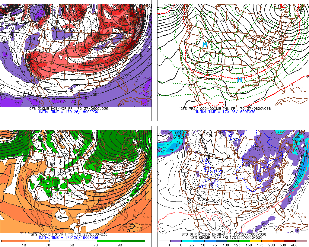
A long duration snow shower event, featuring lake and terrain enhancement at times, will occur Thursday through Monday east and southeast of Lake Erie, bringing locally heavy amounts of snow by the time the event runs down. It would have been nice if the lake were several degrees warmer or if temps aloft were several degrees colder, but I suppose we’ll have to make do with what we have after over two weeks of virtually no snow in the dead of winter.
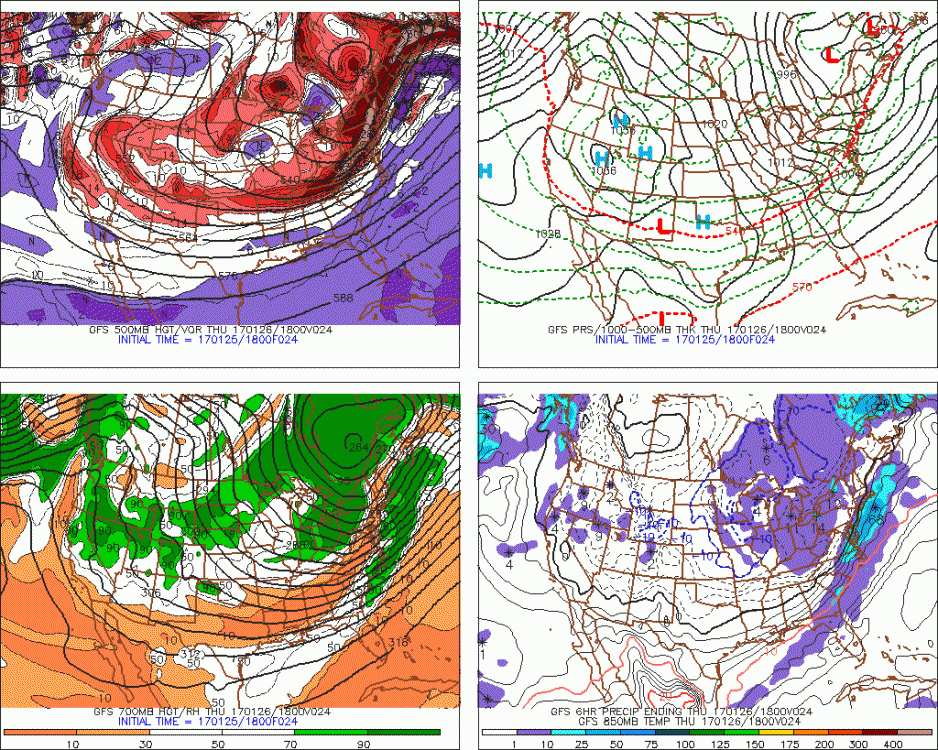
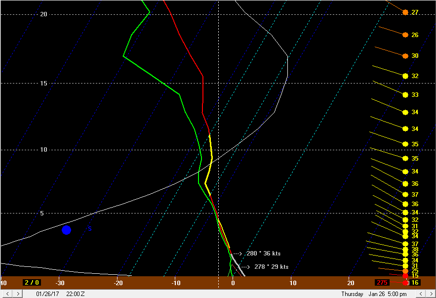
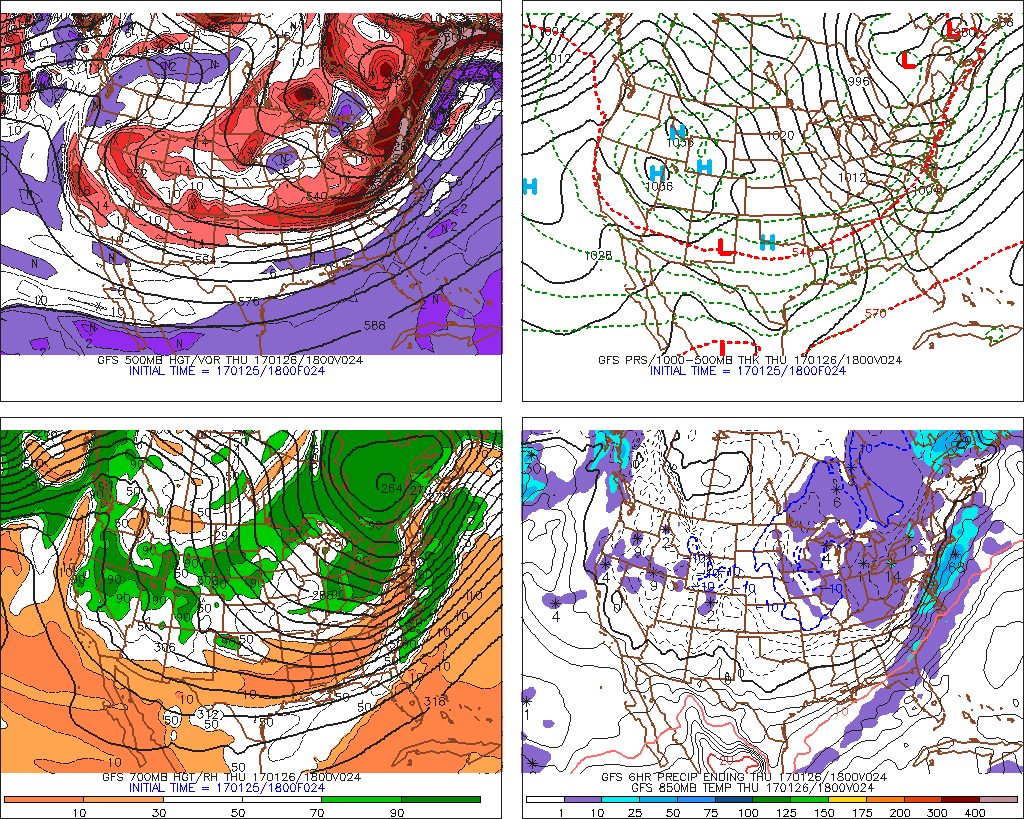
The action starts this afternoon (Thursday) as a shortwave trough aloft and surface trough/wind shift drop ESE across Lake Erie and NE Ohio. 850mb temperatures of around -5 to -6C and 925mb temps of around -1 to -2C, with surface temps in the 30s is marginal for supporting all snow during the day Thursday. I’m sure any decent showers would fall as snow or grauple and locations higher than 1000 feet in elevation could remain all snow or grauple as well, but in the lower elevations it may not be all snow.
The shortwave will provide a shot of lift thanks to positive vorticity advection aloft along with good moisture to nearly 15k feet. Low level lapse rates will be conditionally unstable, and the surface trough should provide enough convergence to focus some bursts of moderate precipitation across northern Ohio as it drops through during the late morning and afternoon. Frictonal convergence could favor a more organized band of precipitation from the western lakeshore east through the Cleveland metro into the southern Snowbelt that moves more slowly. Ororgraphic lift in parts of this corridor may also contribute to better precipitation. Lake to 850mb temp differentials are only running around 7C during the day Thursday so I expect little lake contribution to the instability, but the layer of steep lapse rates and good moisture along with sources for lift could squeeze out a good tenth to quarter inch of precip in a corridor from Cuyahoga and northern Medina Counties points east-southeast towards Youngstown on Thursday. Snow ratios will be 10:1 or less due to the strongest lift being focused beneath the DGZ (zone where temps are between -12C and -18C) and also due to mild surface temperatures, so most areas should see less than an inch of snow…but locations about 1000 feet that perhaps see this better “band” for a few hours could squeak out a couple of inches by Thursday evening. NW PA will also see several hours of decent orographic lift on Thursday and may see slightly colder temps/better ratios thanks to higher terrain, so there could be some 2-3” amounts in the higher terrain in inland NW PA, with probably just about none near the lake.
I’m not extremely impressed with the setup for Thursday night, as we will be in a region of large scale sinking motion between two shortwaves. The mid levels will dry some and other than some upslope there won’t be any good sources for lift. With a slightly north of due west mean low-level flow Friday night with little shear, moisture to 6-7k feet, inversion heights around 7k feet, and lake to 850mb temp differentials of 10-11C, there could be some minor lake effect snow Friday night. The best shot will be in the higher terrain where orographic lift could help wring out the moisture picked up off the lake:
My best guess right now for Thursday night is an inch or two of snow mainly along and north of route 6 in NE Ohio…especially in the higher terrain, probably an inch or less along the lake…and 2-3” in the higher terrain in inland Erie County Thursday night. Not really heavy but some snow should continue off and on through the night, particularly in NW PA in the higher terrain. Some Lake Michigan moisture could allow for a few snow showers with local minor accumulations south of route 6 in the rest of the NE OH Snowbelt Thursday night. Snow ratios will improve a bit as the DGZ lowers and as surface temps cool below freezing.
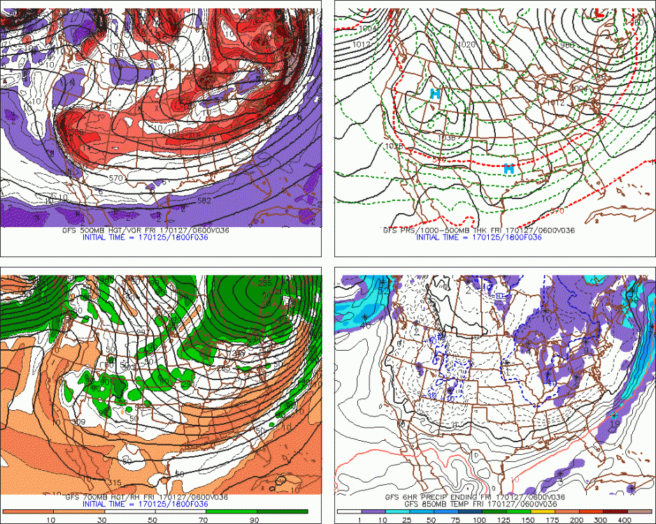
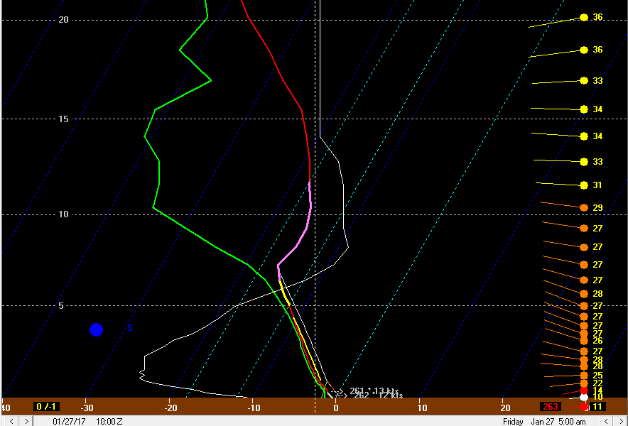
The next shortwave will move through Friday afternoon, with an accompanying increase in mid level moisture and some large scale lift. The winds will back to the WSW Friday morning and early afternoon ahead of this shortwave, which may focus a band along the shoreline from eastern Lake County east across Ashtabula County into Erie County for a few hours during this timeframe.
Instability will still be less than stellar, with lake induced equilibrium levels only around 7k feet. With that said, steep low level lapse rates and good moisture to about 9k feet along with some convergence along the shoreline could allow for some moderate snow Friday afternoon as this shortwave approaches. The low level winds feature some shear on the models, so this combined with marginal instability may make it hard to sustain snow rates of more than an inch an hour. The fairly strong and somewhat more WNWrly winds around 850mb may allow the snow to penetrate inland some in Erie County east into SW NY Friday afternoon. This setup on Friday may again allow another inch, maybe two, of snow in extreme NE Ohio from parts of Lake County into northern Ashtabula County, with perhaps 2-4” across parts of NW PA. With questions about band organization I have a hard time seeing anyone getting much over 4” in NW PA during the day Friday, but some light accumulating snow could occur over most of Erie County during the day.
Friday night again is a less than stellar setup for heavy snow…there will be a brief more WNW push of winds Friday evening behind the shortwave, which may push the snow a bit farther inland. Mid-level moisture again decreases later Friday evening and inversion heights come down to less than 5k feet as we get some sinking motion behind the shortwave, so any snow may taper again for several hours Friday night. I think some spots in far NE Ohio and mainly Erie County in NW PA could see 1-2” Friday night, but I struggle to see a ton more.
Another shortwave glances the region Saturday morning, and this could lead to a brief increase in snow. With WSW winds ahead of this shortwave and no real push of WNW winds behind it (due to the shortwave passing mainly to our north), this snow should mainly affect Erie County and perhaps graze the lakeshore in parts of Lake and Ashtabula Counties. This shortwave just barely glances us so there won’t be as great a shot of large scale lift or mid-level moisture, and inversion heights may struggle to climb back too far above 5k feet…so there may be an inch or two of snow with this shortwave Saturday morning in the lakeshore in far NE Ohio into parts of Erie County, but I struggle to foresee much more at this time. There should again be a break in the snow later Saturday morning into the afternoon in the sinking motion behind the morning shortwave, and also as winds begin backing to the southwest ahead of a series of more potent shortwaves.
A band of heavy snow will likely develop just south of a BUF on the SW flow Saturday afternoon with better antecedent moisture up there, a 13C lake to 850mb temp differential over eastern Lake Erie and full fetch of the lake. This band could persist for several hours and produce over half a foot of snow.
The models agree on two potent shortwaves or really more like small upper lows dropping through the Great Lakes Saturday afternoon through Monday morning. They do NOT agree on the exact tracks of these shortwaves and exact impacts on our lake effect/enhanced snow potential.
The Saturday night scenario is complex, as the models show two separate shortwaves tracking west to east across the region. It is possible we get split by the two shortwaves completely, in which case the best lake effect may remain to our north with less of a push of winds to the WNW. If the northern shortwave tracks overhead, we’d likely see a heavy snow band work its way down the lakeshore and into the Cleveland metro Saturday night into Sunday morning with winds shifting to the WNW by Sunday morning. The models show 500mb temperatures dipping solidly below -35C with the shortwave Saturday night, so if that shortwave can track far enough south there’d be a deep layer of instability over the lake…to go along with deep moisture to around 10k feet and good convergence with the wind shift associated with the shortwave. This is the first decent potential for advisory to locally warning criteria snow in NE Ohio, and there’d be a good chance for some warning snows in parts of NW PA and SW NY depending on how the band evolves as it shifts down the lakeshore.
The 0z NAM was on the fence…it had the shortwave Saturday night/early Sunday far enough south to improve our lake effect conditions some and shift the winds to the WNW. The 0z GFS was a little too far north…while the 0z Euro appears to be close to the NAM or perhaps even a bit better. Subtle trends in this shortwave could mean the difference between another ho-hum 1-3” in the northern primary Snowbelt Saturday night and a more widespread 2-4” (perhaps locally more). The GFS ensembles over the last several runs have trended deeper with the overall trough over southeastern Canada, which is a favorable trend. We will see what happens:
There will probably again be somewhat of a break in the snow later Sunday morning into the afternoon as we get into some sinking motion (briefly) behind the Saturday night/Sunday morning shortwave. Another impressive shortwave will round the base of the trough Sunday night and this one will likely move overhead.
This shortwave will actually try to swing around to neutrally tilted per the current model consensus Sunday evening, which may allow a low pressure to attempt to start forming nearby before the energy moves east of the Apps by Monday morning. This shortwave could bring several hours of good large scale lift along with a deep layer of moisture and instability. The wild card is the exact track of the shortwave and any low that tries developing. If a low develops over the lake or over northern Ohio, there could be several hours of heavy lake enhanced snow. If the low develops farther north, the snow could lift north into NW PA or perhaps SW NY and give us just a quick band with the wind shift as the whole trough shifts east/southeast later Sunday night.
Again, there’s considerable uncertainty with Sunday night’s situation. The general trend on the models has been a little more robust with this shortwave, which if it occurs would be interesting. There should, either way, be another burst of accumulating snow in the Snowbelt Sunday night into Monday morning, but the exact amounts and placement won’t be known for at least another couple of days…this is still about 4 days away which is quite far out. Ridging should build in Monday and end the snow by early evening.
Some of the forecast parameters for Sunday night into Monday morning are eye-popping…but we have a few days to watch the evolution of that potent shortwave so things may change. A burst of heavy snow is certainly possible though depending on the wind direction Sunday night into Monday morning.
As for amounts…thinking an inch or two in the higher terrain in the primary and secondary NE OH Snowbelts on Thursday, little to no accums in the lower elevations. Could see 2-3” in the higher terrain in NW PA with little near the lake. For Thursday night thinking an inch to locally two in the higher terrain in the northern NE OH snowbelt, with maybe half an inch here and there a little farther south if we can see some Lake MI snow showers…up to 2-3” in inland NW PA, with around an inch near the lake. For Friday thinking maybe an inch along the lake in Lake and Ashtabula, and 1-4” across Erie County, with the 3-4” amounts occurring where/if a better band can try to establish. For Friday night thinking maybe a local 1-2” in extreme NE OH into Erie County PA. Saturday again maybe a quick 1-2” in parts of Erie County, little to none elsewhere.
Saturday night will go for a widespread 3-5” for Erie County and 2-4” in the primary NE OH Snowbelt into Crawford County PA…and 1-3” back into the secondary Snowbelt (including the Cleveland metro) west into Lorain County…but this is less than certain and I could see more or less occurring in spots. Will not expect more than a local inch or two during the day Sunday as we look to see a break. For Sunday night I will go for 2-4” in the primary NE OH Snowbelt and 1-3” in the secondary…with an inch possible well west and south since there’s good synoptic support. I’ll go 1-3” for NW PA for now. Sunday night into Monday is pretty uncertain, and this is a conservative, broad-brushed first guess for now.
This pushes totals to 10-18” in inland Erie County…possibly more near the NY boarder in the higher terrain where the higher ends are more likely to be met on a period to period basis…to 6-12” in Geauga County to 3-6” across the Cleveland metro. A lot of this potential snow is occurring Saturday night through Monday and I broad brushed that for now…it could end up being more or less…but in the interest of rolling this all into one first guess forecast I gave it a shot.