OHweather
-
Posts
5,046 -
Joined
-
Last visited
Content Type
Profiles
Blogs
Forums
American Weather
Media Demo
Store
Gallery
Everything posted by OHweather
-
The upcoming LES is a half decent setup, but wind direction isn't our friend...it looks like the best snow will likely be north of route 6, and some guidance suggests the snow staying even closer to the lake than that. Wherever the band locks in from mid-Thursday morning through Thursday evening could see over half a foot of snow...assuming that happens on land and not just out over the lake. Lake County, northern Ashtabula County, mainly northern Erie County, and perhaps extreme northern Geauga County appear to be best positioned for this one. Elsewhere, we're waiting until at least the weekend.
-
Yeah I'm not optimistic for the Weds-Thursday event. Maybe better chances behind the clipper over the weekend and at times next week.
-
I'm glad you got some snow there in NW PA! Thanks for the kind words. Elsewhere there was a report of 3.5" in the middle of nowhere in NE Geauga County but most other areas were 2" or less which was a bit disappointing. And unfortunately down in Brunswick you really need at least a NW wind to get good LES. It'll happen a few times each winter and your terrain helps some but the best action is usually farther north/east.
-
0.6" here thus far. The snow has really wound down in the past couple of hours which I didn't expect so soon...the HRRR insists on it re-developing soon, but we'll see. The band never really persisted over me, just grazed me at times. I was down in Macedonia around 5pm and they had a little over an inch with moderate to heavy snow with big flakes still falling.
-
The RAP and NAM both have the winds backing a little bit more towards the W through about 6pm before veering to the WNW until late evening, so there's probably a weak surface trough passing. This may lift the bands a bit north over the next hour or two before they settle back south for a few hours later this evening. We should see the band consolidate nicely as the weak surface trough/wind shift approaches, and it sounds like it's starting to accumulate under the better bands. I'm in Bedford Heights now and think I should be in an OK spot. I'm still getting some graupel here at the moment and am hoping it changes to all snow as it cools a bit more.
-
Good hi-res agreement on 4" or so of snow with the band this evening, which I think seems reasonable. There's probably enough instability and snow growth for 1" or so per hour with the band, but I kind of doubt we see big 2 or 3" per hour rates. The NAM is impressive in that it doesn't move the winds more than 5 degrees in the boundary layer for several hours this evening, so the band should be fairly stationary which is why I think a few inches is a good possibility. The winds seem like they'll be in the 280-285 range by late this afternoon when the band should develop which may suggest it hits more of Cuyahoga County than my forecast yesterday...I may tweak that in a little bit. Edit: I'll go with this as my "final call"...we will see. Starting to see some signs of organization, need it to get a little colder so it can accumulate well.
-
Don't have time to elaborate much at the moment, but the lake effect looks briefly decent Sunday evening...here are my current thoughts (apologies again to those in NW PA for not getting a map background that includes you yet). The gist...not expecting much if any accumulation through early Sunday afternoon. Mid to late afternoon a shortwave approaches and steep lapse rates/moisture extend to about 7k feet (with higher lake-induced equilibrium levels of near 10k feet). With well-aligned WNW winds and a NW to SE oriented isobar pattern expect a band to initially develop over western/southern Cuyahoga and shift NE and become locked in from near Cleveland to the eastern suburbs into northern and central Geauga County during the evening as winds back to 270-280 due to the ridging building in on land. Favorable conditions with upstream moisture from Lake Michigan, moderate instability, moisture depth of over 5k feet, and some large-scale lift from the upper-level trough along with convergence with the band suggest moderate to heavy snow is possible through about midnight. Winds don't move much so someone could see a quick few inches with the band. Expect the band to shift up the lakeshore and weaken after midnight as ridging moves in, inversion heights lower and the low-levels dry out. In NW PA with more elevation, potential moisture from northern Lake Michigan, and a deeper layer of instability over the lake expect a similar setup with perhaps more widespread snow outside of the main band Sunday late afternoon and evening. Better moisture/instability last into Monday morning as one last little gasp of synoptic supper moves by, and the remnant convergence band should affect Erie County for a few hours early Monday. This leads to higher potential accums...am thinking widespread 3-5" in inland Erie and northern Crawford County with potential for locally up to 8" mainly in a narrow corridor in parts of Erie County if a more distinct band can develop for a few hours. Could also see a couple inches down to the lakeshore with the convergence band Monday morning. Eastern Cuyahoga/southern Lake/northern Geauga may flirt with the 4" advisory criteria if the band is persistent enough...I expect Erie and Crawford Counties to need an advisory, and with such a prolonged period of fairly steady winds and borderline extreme instability to go along with enough moisture, if a focused band develops some spots could get close to warning criteria.
-
The Euro will win this weekend with it's much quicker/weaker storm and less impressive LES event...though some snow is still likely. There may be a brief window of synoptic snow and lake/orographic enhancement late Saturday night into Sunday morning. Temps look marginal, the window is only a few hours, and rates only look light to moderate, so this may produce perhaps an inch of slush in the higher terrain downwind of the lake in Ohio and perhaps 1-2" in the higher terrain of NW PA. Still time for trends but at the moment that looks like an optimistic forecast. Some LES still looks likely Sunday and Sunday night. We get a window Sunday late morning and afternoon with a NW flow with moderate instability, marginally enough moisture, lift from a shortwave and perhaps some upstream lake connections. With the short fetch, marginal moisture, and temps likely above freezing I don't expect much out of that, but some briefly moderate to heavy snow showers that drop a light accumulation, especially in the higher terrain, seem possible. Accumulations may remain possible Sunday night as the winds back to the W and WSW and possibly focus a briefly organized band of better snow into extreme NE OH and NW PA, but lowering inversions and drier air will also limit that potential. Between the synoptic snow and lake effect I think this is a 1-3" event in the higher terrain in NE OH and perhaps 2 to locally 5" in NW PA, and those high ends may be optimistic. Closer to the lake may stay too warm for any accums.
-
The Euro continues to be complete garbage. Minor event. Normally the GFS is progressive and the Euro slower/amped, so this will be interesting.
-
This weekend could be a nice LES event locally...too early for a lot of confidence or for details though but it's one to watch.
-
Got a dusting here overnight. Still lightly snowing and hoping the Huron band can drop a light amount, but it's moving pretty fast.
-
It's nice to be forecasting snow! Hopefully the next event is more substantial...at least we don't have an endless torch like the last two falls.
-
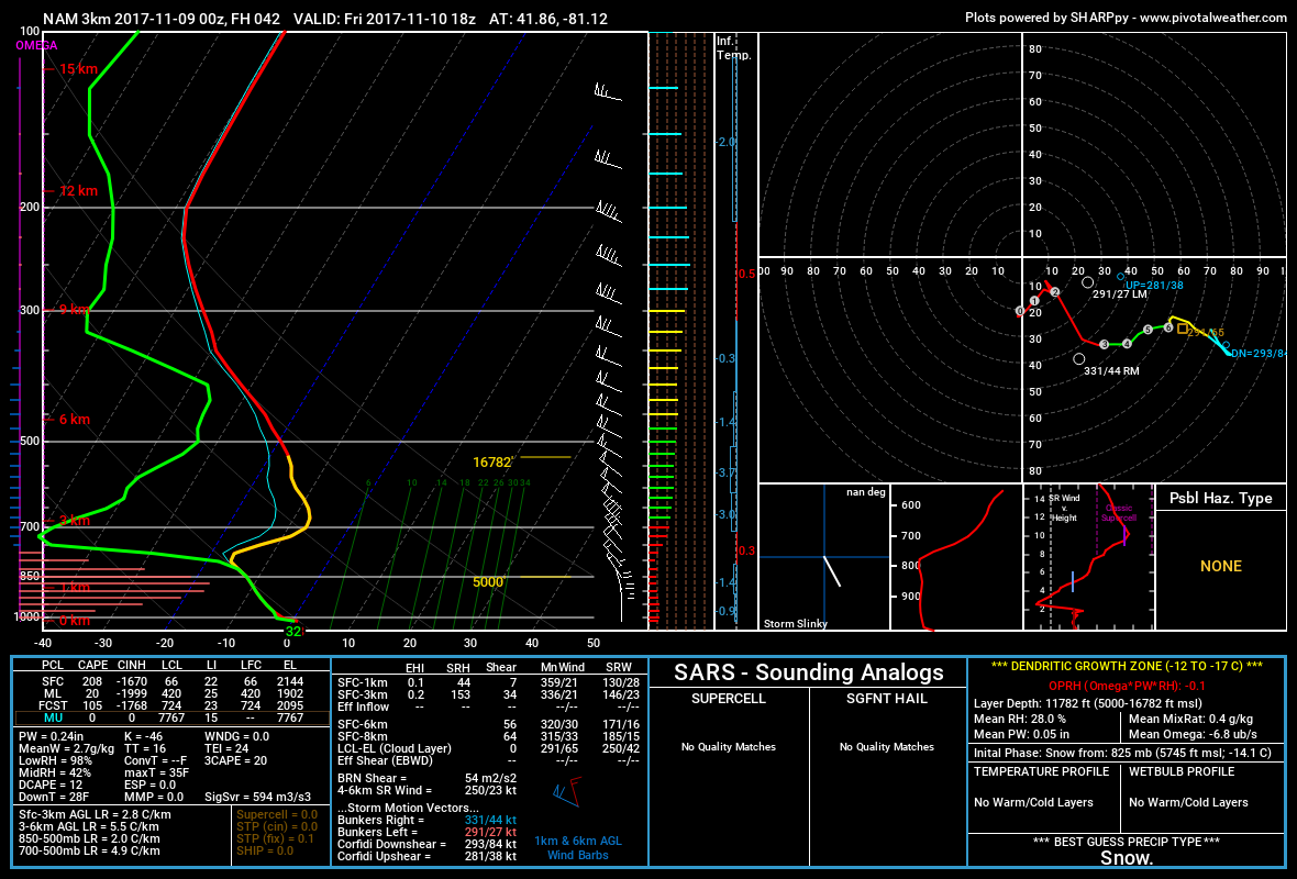
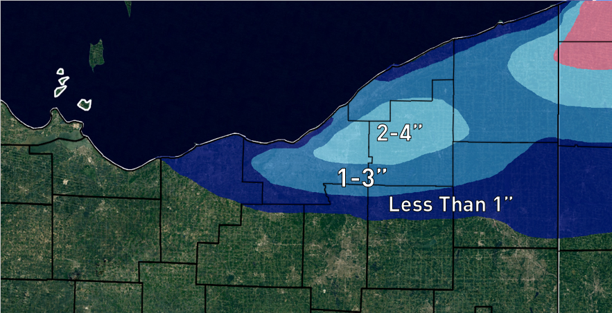
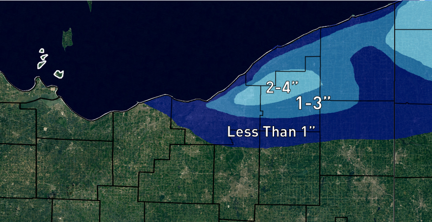
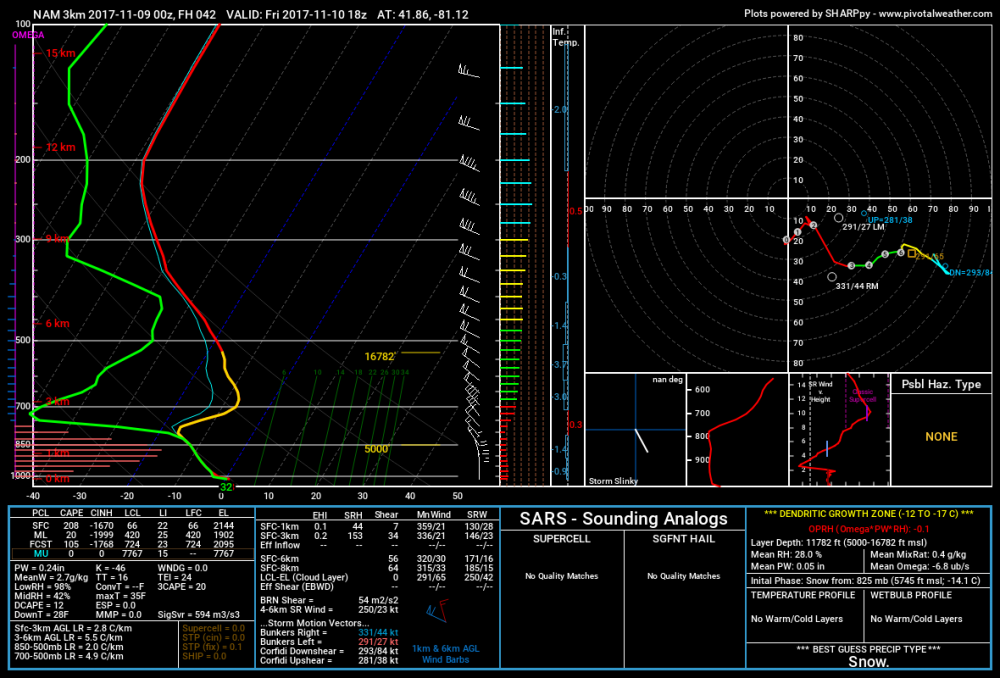
I will never write this much about this little snow ever again...but since it's the first of the season, might as well. Also, I didn't realize I cut off 70% of Erie and Crawford Counties in PA until it was way too late for me to consider re-doing my county outlines tonight, so I apologize that I left those areas off of this map. A lobe of the polar vortex grazing the region will bring a brief shot of very cold air for the time of year, with 850mb temperatures falling to around -16C. Despite the extremely cold air in the low-levels, the trough only grazing Lake Erie and the high pressure building in quickly will cause lowering inversions, dry air, and a short fetch to limit the potential of this lake effect event. After high temperatures pushing into the lower 50s Thursday afternoon, the strong cold front will cross early to mid-evening marked by a sharp wind shift and wind increase behind the front and quick drop in temperature. There will be good low-level lift along the front, though moisture will be lacking and the best chance for any precipitation will be downwind of Lake Erie. Forecast soundings along the front show a fairly deep layer of good moisture and steep lapse rates up to around 8k feet at CLE, which along with good lift below about 7k feet should be enough to get a band of showers pushing in off the lake. Freezing levels are expected to initially be too high for snow, though moisture does get into the lower portion of the DGZ and the precipitation will be convective, so some graupel could mix in. The layer of instability is a little bit deeper farther up the lakeshore, so there may be a better chance of graupel farther up the shore. Behind the immediate front there could be a lull in any shower activity for an hour or two, however, a secondary surface trough along with some mid-level lift is expected to push onshore around 3z/10pm, likely bringing another chance at precipitation: Between convergence along the trough as winds shift from WNW to more NW/NNW and frictional convergence along the shoreline, there will likely be enough focus for a line/band of precip to push southeast off the lake rather quickly late Thursday evening. The above model image is surface moisture convergence off of the NAM, and shows some enhanced convergence near the lakeshore coinciding with the trough passage (also note how some weaker convergence extends farther west along the trough, possibly bringing flurries outside of the lake effect areas). This secondary trough will likely be enhanced by a shot of mid-level vorticity grazing the region shortly behind the cold frontal passage. This PVA will also add some lift and enhance precipitation chances. By the time this secondary trough pushes through, conditions will be a bit more favorable for lake effect. The winds are a little strong with some shear above 6k feet, which will likely limit any organization with the band of precip that pushes through, but there will still be a deep layer that is moist and very unstable. 850mb temperatures will quickly be falling to around -10C as this secondary trough pushes through which is cold enough for snow…though temperatures at the surface will likely still be near or a bit above freezing. All in all, after an initial round of mainly rain showers with the initial front, a secondary round of snow showers (that may be briefly heavy) will likely move through the Cleveland metro and east side (as well as all the way through the Snowbelt and into NW PA). The disorganized nature of these snow showers and brief window will limit potential accums, but some areas could see a quick dusting (perhaps a half inch to local inch if there are any particularly heavy snow showers). There will then be a bit of a lull in the sinking motion behind this trough until some upstream lake connections can develop later Thursday night and into Friday morning. There will be two potential upstream connections to watch for as the winds come around to the NNW later Friday night: 1) A Lake Superior/Michigan connection that initially sets up on the east side after midnight and gradually settles towards the southern suburbs by Friday morning, and then likely dissipates as the high builds in on Friday. 2) A Lake Huron connection that moves into NW PA late Thursday night and then gradually slides west (while slowly weakening) through the day Friday as the winds continue to come around to the N and even NNE by Friday evening. Above is a forecast sounding for CLE when the potential Superior/Michigan connection would be developing. There is a lot of dry air however, there is some moisture below the inversion along with very steep lapse rates. This combined with very little shear and somewhat weaker winds could allow for a loosely organized band to develop across parts of southern Cuyahoga, extreme NE Medina, northern Summit, and perhaps southwestern Geauga/northwestern Portage Counties for a few hours later Thursday night into Friday morning, before the possible band shifts farther west/likely dissipates later Friday morning. With the entire cloud layer in the DGZ and over 700 J/KG of lake induced CAPE in the sounding, any snow showers that develop could be heavy enough to accumulate…however, with a short fetch, dry airmass, and complete lack of any synoptic scale lift in the region, it’s hard to get excited. Could someone sneak out a local inch of snow, and maybe a larger area see some light dustings in the higher terrain just south and southeast of Cleveland out of this? Sure...but given the negatives and short duration I have a hard time seeing more than a local inch or so of snow panning out with this potential “band,” and even that I’m not completely confident in…it could just end up being flurries if the upstream connection isn’t strong enough to overcome the drier air. A sounding at KERI valid when the Lake Huron band is expected to begin moving gradually southwest across NW PA is more impressive, with a deeper layer of instability and moisture and manageable levels of shear. There is enough “juice” there for the Lake Huron band to produce moderate to heavy snow…however, the winds will still be shifting so it may not spend more than an hour or so in any given location in NW PA, with only light snow showers in the higher terrain outside of the band. If the band slows down somewhere, a narrow corridor could see a quick 2-4” of snow, but otherwise this is looking like a quick inch or two in the higher terrain of NW PA with just a coating closer to the lake shore. Given the potential timing Friday morning this could still interfere with the commute. As the winds continue to gradually shift to a more northerly direction on Friday, the Lake Huron band will continue west into northeastern Ohio. The band will likely not spend an hour or two in any given spot, limiting potential accumulations. Forecast soundings from within the band still support moderate snow within it into Friday afternoon, with good moisture/steep lapse rates up to about 7k feet and good lift into the DGZ, along with only weak to moderate wind shear, so some quick accumulations can’t be ruled out, but in general amounts from the Huron band in Ohio will struggle to pass an inch or two. The hi-res models insist on getting the Huron band into the Cleveland metro by late Friday afternoon/early evening, but drier air and lower inversions will continue to work in, making it questionable how intense it is when it gets in: Lapse rates remain steep with enough moisture below 5k feet, to go along with some instability into the DGZ and little wind shear below the inversion, so there’s probably enough juice there for light and somewhat high ratio snow…however, with the band likely continuing to move and snow rates kept on the lighter side, I have a hard time seeing more than about half an inch of new accumulation in the higher terrain in southern and eastern Cuyahoga/northern Summit/northern Medina with perhaps a light dusting closer to the lake and a bit farther west before the band completely dissipates. For total amounts, am generally thinking 2-3” total in the higher terrain in NW PA when combining the late Thursday evening snow showers and Huron band passage early Friday morning…a local 4” is possible if the Huron band slows down anywhere, but that’s not a given. In general am thinking 1-2” total in the higher terrain in northern Geauga and inland Ashtabula County when combining the Thursday evening snow showers and Huron band passage…I can’t rule out a local 3” amount if the Huron band slows down anywhere, but again, not a given. In the Cleveland I can see how someone in the hills south or southeast of town squeaks out an inch or inch and a half of total snow if both phases of the event pan out, but the lower elevations will likely see a dusting at best, and even in the higher terrain of the secondary Snowbelt it’s very possible an inch doesn’t even fall, as neither portion of the event looks like a given for that area. And here's my forecast:
-
That's definitely some impressive tree damage. CLE did issue a pretty long statement this afternoon about the corridor of damaging winds...no evidence of rotation, but estimating gusts of up to 105MPH in some areas which will do a lot of damage. Very rare for this area to get such strong winds...and also a lot of tornadoes, especially in north-central OH ...STRAIGHT LINE WIND DAMAGE CONFIRMED FROM SOUTHEAST LORAIN COUNTY OHIO TO SOUTHERN GEAUGA COUNTY OHIO... Location...Southeastern Lorain County, Northern Medina County, Southern Cuyahoga County, Northern Summit County, Northern Portage County, and Southern Geauga County Date...November 5, 2017 Estimated Time...5:40 PM to 6:30 PM EST Estimated Maximum Wind Speed...105 mph Maximum Path Width...7 miles Path Length...58 miles Fatalities...0 Injuries...0 * The information in this statement is preliminary and subject to change pending final review of the event(s) and publication in NWS Storm Data. ...Summary... The National Weather Service in Cleveland OH has determined that the damage from Southeast Lorain County to Southern Geauga County Ohio on November 5, 2017 was thunderstorm straight line wind damage from a series of microbursts or macrobursts. A squall line moving west to east produced significant straight- line wind damage in southeastern Lorain County, northern Medina County, southern Cuyahoga County, northern Summit County, northern Portage County, and southern Geauga County. Based upon the damage received in these locations and radar data, it is determined that a downburst produced winds up to 105 mph through the affected area. Wind damage was reported as far west as Lagrange, Grafton, and Columbia in southeastern Lorain County with trees and power poles downed. The microburst wind continued east into northern Medina county, where significant tree and power pole damage was noted in Liverpool Township and the Brunswick Hills areas. Damage in Cuyahoga County was mainly limited to south of State Route 82 in Strongsville, North Royalton, Broadview Heights, and Brecksville. There was extensive tree damage to these areas with many trees snapped or uprooted to the east, some falling into homes and cars. The damaging winds continued into northern Summit County. Significant damage, mainly from falling trees, was noted in northern Richfield, Sagamore Hills, Northfield Center, Macedonia and Reminderville. The most intense damage from this event appears to be in the Twinsburg area in Summit County. Widespread tree damage occurred with trees falling onto residences and cars across the city. Siding was peeled from homes. East of Twinsburg, damage occurred across the county line in Aurora. An automated wind sensor in Aurora measured a peak wind gust of 105 mph. Trees and power poles were downed across the area; with the bulk of the damage occurring along State Route 82 and north. There was also damage at Aurora High School with metal bleachers displaced at the athletic fields. Mantua Township also suffered significant tree damage with several trees snapped and displaced to the east. Geauga County suffered extensive straight-line wind damage, mainly in the southern townships. Aside from the tree and power pole damage, a church steeple was toppled in Bainbridge Township and a fire department communications tower fell in Auburn Township. Trees fell onto several residences across this area as well. The damage across all of the areas outlined above prompted school closures for a number of school districts and numerous road closures that have continued for several days. Power outages were extensive. This information can also be found on our website at weather.gov/cle. For Reference: A microburst is a convective downdraft with an affected outflow area of less than 2 1/2 miles wide and peak winds lasting less than 5 minutes. Microbursts may induce dangerous horizontal and vertical wind shears, which can adversely affect aircraft performance and cause property damage. Straight-line winds are generally any wind that is not associated with rotation, used mainly to differentiate them from tornadic winds. A macroburst is a convective downdraft with an affect outflow area of at least 2 1/2 miles wide and peak winds lasting more than 5 minutes. Intense macrobursts may cause tornado-force damage of up to EF3 intensity. Straight-line winds are generally any wind that is not associated with rotation, used mainly to differentiate them from tornadic winds.
-
It's possible, although that area was apart of some extremely strong downburst winds that tracked from eastern Lorain County all the way through southern Ashtabula County (estimated by the NWS at 125MPH in SE Ashtabula County, and an "unofficial" measured gust of 105MPH in Aurora) so it's possible that there was a corridor of very strong straight-line winds there as well. Did you happen to notice what direction the trees blew down in? Regardless, we're switching gears quickly with the first LES showers of the season Thursday night into Friday. It's a short fetch event with limited moisture so it won't be impressive, but snow showers/flurries should be around and it'll be very cold for this time of year.
-
In all likelihood at least for the first portion of it. We may rip off 6 straight 90+ days at CLE starting yesterday and lasting through Tuesday. Pretty wild for so late.
-
I suspect some of this is still a hangover from all the heat put into the atmosphere during the super El Niño, but I think it's pretty apparent that our "normal" is going up. It's been quite a stretch of warmth. Eventually we will get a string of normal or cooler than normal months and it'll feel unusual given how long this warmth has lasted. Early hints are that the heat backs off in early May for at least a time...while the rest of this week runs of April's average up some more.
-
A few different reports of 6 to up to 10" in northern Medina and southern Cuyahoga County. Bedford Heights has roughly 6" and driving through northern Solon on my way in there was a bit more there...so some areas did quite well.
-
For your area especially, with the exception of the 20-30" that you missed out on in early December all of the events performed pretty well. When you get 10 or 15" at a time it does add up. But the two or three week snowless spells really took the wind out of this winter's sails, and areas that didn't get LES did really badly. I feel like most of the LES events that made it down here performed pretty well too.
-
After a little more snow and a few measurements, came with a total of 3.4". Pushes me over 60" on the season (60.4") which is about 75% of normal (figure maybe an 80" average out here)...all things considered, compared to how the west side is doing, I suppose I can't complain much.
-
About 3" here. A spotter in Twinsburg reported 4" so they must've gotten more, I can't justify that much here. Too bad the lakeshore got zero...though not shocking. KERI saw 3-4" and they're almost on the lake, but they may have seen heavier precip or something up there.
-
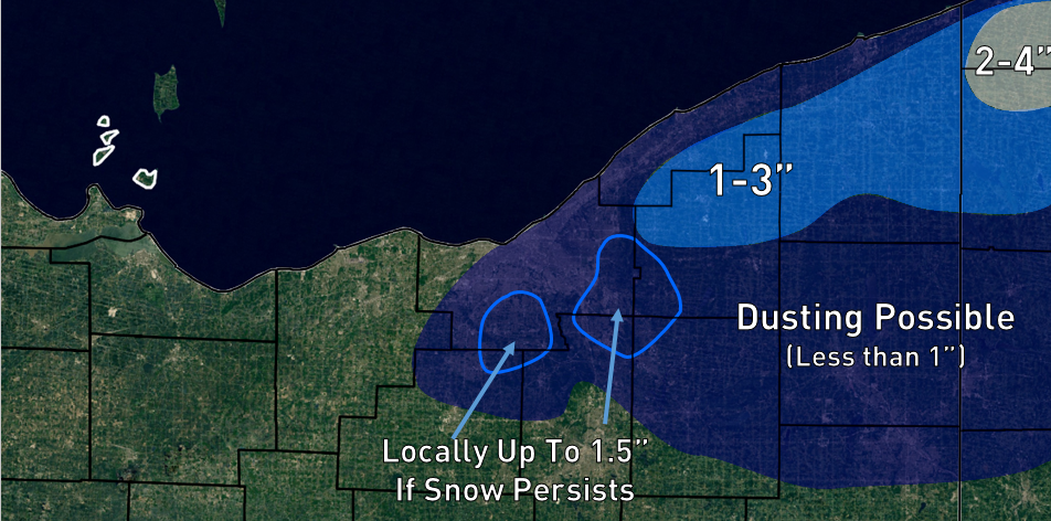
Looks like the low will pull away too quick for a huge snow...but a good 3-6" in the higher terrain from Medina points NE with more in inland NW PA seems like a good bet. Would expect 2-3" by the time you get down to Akron and Ravenna and 1-2" of slush along the lake. The hi-res models have a good 0.5-1" of QPF as snow in the higher terrain tonight but think some initial melting/low ratios/shorter duration than it could be may make it hard to see over 6". If we can get prolonged 1-2" per hour rates someone would pull that off but I'm not super optimistic attm. Even so think CLE needs some advisories for the secondary and primary Snowbelt overnight into the morning. Some areas could see some tree/powerline issues with the gusty winds and heavier snow accumulations on the trees.
-
There were two impressive events in 2005...the one at the beginning of the month and then April 23-25, which was more significant for Cleveland proper...that may be the one that dropped 23" on you as I saw 20" in Solon. The early April event dropped about 8" IMBY. What a month to cap off a record setting winter that year. Models this afternoon thus far remain encouraging. I'm thinking the high terrain will need at least advisories and if the hi-res models are right and we squeeze out some good lake enhancement this could actually need a warning for some areas.
-
Still a good amount of uncertainty in the snow for tomorrow night into Friday, but some ingredients are in place as we'll get into a slow moving deform zone west of a very slow moving cut/off and stacked storm over upstate NY Thursday night and Friday with temperatures becoming cold enough for decent lake enhancement and upslope by late Thursday night. There's disagreement over how quickly we changeover Thursday evening and over how long it lingers into Friday, and a lot of that has to deal with how little vort maxes rotating around the upper low act which is not easy for the models to get right. The lakeshore will get less than the higher terrain and may not end up seeing much (if the higher end solution pans out maybe the shore can see 2-3" of slush), however right now I think 2-5" is a good first call for the higher terrain. That could get up considerably if things go perfectly and we changeover and the low doesn't move away too quickly into Friday, which some models have shown off and on. The surface and upper level evolution are somewhat close to the April 2-3, 2005 storm which was a widespread 4-8" across north-central and northeast OH with 18-30" in the higher terrain from northern Geauga County into NW PA. The surface low with this one initially will be farther north than that one (the similarities start when the system really slows over upstate NY) which may ultimately make it impossible to see totals close to that storm.
-
The models (especially the Euro) have been hinting at some potential wrap around/lake enhanced snow at the end of the week. The Euro is solidly cold enough for it to occur when comparing it to past similar April events but the GFS is more marginal temp wise and moves the heavier precip out quicker. The storm will be closed off when it passes is so predictability this far out probably isn't great, but the Euro ensemble mean last night was a solid 2-4" (a few members had nothing and a few members had like 10" with most in Between) so I'd say there's support for the potential. The airmass even by April standards could be colder so this isn't a slam dunk though.