OHweather
-
Posts
5,046 -
Joined
-
Last visited
Content Type
Profiles
Blogs
Forums
American Weather
Media Demo
Store
Gallery
Everything posted by OHweather
-
Not that we want it, but it's looking like a fairly snowy weekend especially in the higher terrain east of Cleveland, through NW PA and southwest of Buffalo. A couple of troughs move through during the day Saturday and will likely cause upticks in rain/snow (mainly snow in the hills, but may mix with rain in the lower terrain as the boundary layer will be fairly "warm" during the day Saturday). There's a deep enough layer of moisture and steep lapse rates to go with it, so the snow may be bursty at times during the day Saturday and could stick a bit in the higher terrain. However, the best accumulations will occur Saturday night into Sunday. A couple little spokes of energy move through, one Saturday evening and another late Saturday night into Sunday morning and will likely bring relative upticks in snow. It should change to all snow fairly quickly Saturday evening and begin accumulating in the hills better around sunset, with ratios improving overnight as the DGZ lowers and surface temps drop well into the 20s. The burst in the evening will be more synoptically driven with a bit of lake enhancement/upslope with 850mb temperatures falling from around -8C to -12C by 2 AM Sunday, and could be moderate to briefly heavy in the higher terrain. By early Sunday 850mb temperatures drop to around -15C with the DGZ lowering enough for significant lake enhancement/upslope. With a well-aligned WNW flow and lake-induced instability up to 5-7k feet, lake to 850mb differentials of around -18C, good upslope, some upstream connections and synoptic moisture and lift persisting to about 9-10k feet through early Sunday it could snow quite well and also efficiently in the favored higher terrain from parts of eastern Cuyahoga County across the interior snowbelt for several hours into Sunday morning. The synoptic moisture gradually strips away starting Sunday morning from west to east, but enough moisture persists below 850mb with sufficient instability for some LES to continue through Sunday night and early Monday, especially in NW PA where there will likely be a connection to Lake Huron. The snow may become disorganized for a time Sunday afternoon due to the diurnal influence on lake effect this time of year and probably won't be particularly heavy after that, but could accumulate a bit through early Monday where any bands set-up. I suspect there's a great enough window Saturday night into Sunday morning in the higher terrain of the primary NE Ohio snowbelt between when it gets cold enough to really start accumulating in the evening and when the synoptic moisture and lift start stripping away on Sunday to get up to several inches, enough for an advisory. The hills of southern Cuyahoga, northern Medina, northern Summit, as well as locations surrounding the primary snowbelt (i.e. northern Portage and Trumbull) could see a few inches too, especially if moisture doesn't strip away too quickly late Saturday night into Sunday morning. If it cools quicker Saturday evening or if the synoptic moisture lingers longer on Sunday, I could see spots getting 6-10" in the higher terrain of Geauga. I think this will be a warning criteria event with storm totals reaching over a foot in spots in the higher terrain of NW PA, especially in Erie County, as the synoptic moisture and lift will last longer into Sunday and as the Lake Huron connection may keep somewhat better snow going there while NE Ohio is down to lighter LES Sunday afternoon and Sunday night. The lakeshore across the board will see less, but Erie could get a few inches. We'll see how this goes, but these prolonged set-ups with some synoptic moisture and good upslope tend to do well, with the best snow likely occurring at night into Sunday morning when the sun angle influence is lower, even this time of year.
-
Got a little over 3" here, not too shabby. The lake effect so far is quite cellular and battling dry air but has upticked a bit with a couple hints at an upstream connection, one into Lake/northern Geauga, another into Ashtabula County, and maybe another one trying to drift towards the southwest side. We'll see if any of these sustain enough to drop some accumulations this evening as the winds weaken a bit, that may help improve organization despite the dry air.
-
Everything has trended even more progressive in the 0z and 12z runs...feel like even the above map is probably optimistic. Could see up to a few inches in the higher terrain SE of the lake as there will still be some lake enhancement to the light synoptic snow and some lake effect snow showers Saturday afternoon and evening, but this is looking like a minor event in the grand scheme. No big snow threats on the horizon...I'd like one more good snow, but the weather last weekend was quite nice and it's nice to be able to do things outside that aren't snow related now that the pack has completely melted, so I won't argue if we slowly fade into spring from here on out.
-
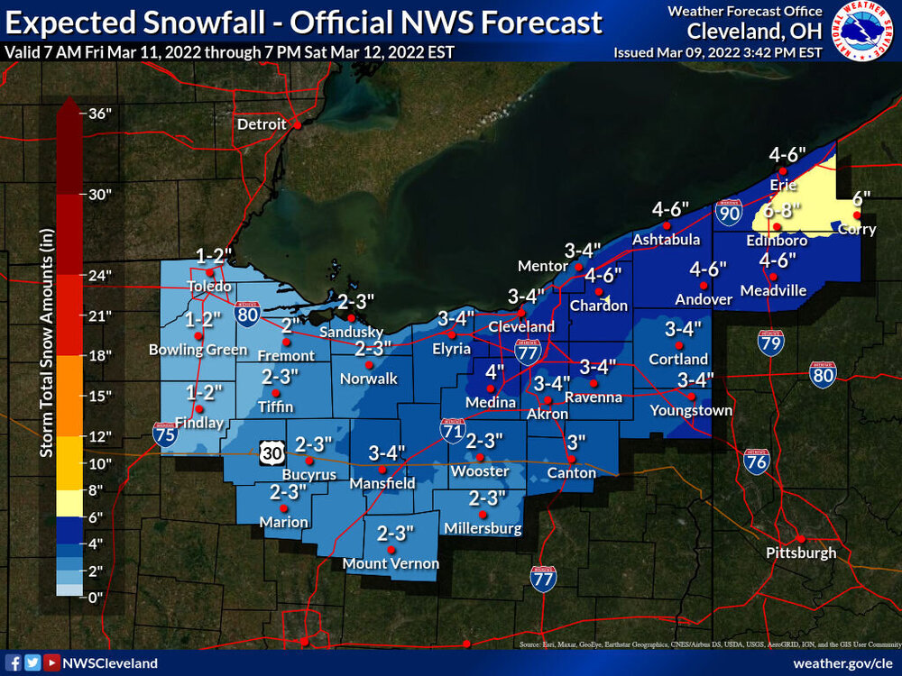
Only have one full forecast package this week, but it included the entirety of the upcoming wintry system Friday evening through Saturday. Here were the snow grids... The synoptic snow is odd...a band of snow driven by mid-upper level lift well northwest of a deepening surface low will gradually slide across the area Friday evening through Saturday morning, with mainly light to moderate snow that can start turning heavier into Saturday. Current issues are that the trough looks positively tilted until Saturday morning and the low jumps quickly to the east coast. Because of that, most models keep the band of synoptic snow somewhat progressive and don't really rip the heavier rates until it exits to our east/northeast on Saturday. Some models, such as the Canadian, are a little less progressive and support over 6" of snow from Lorain and Mansfield points east. It wouldn't take a huge change on the other models to get that, but for now the forecast leaned on the more progressive camp which has much more model support. There will likely be some lake enhancement to the synoptic snow starting late Friday night and continuing until it exits by midday Saturday with a NNW flow and 850mb temperatures cooling enough for lake enhancement. That may be a several hour window in which the higher terrain from Lorain and Medina Counties points east get a nice boost into Saturday morning. Pure lake effect takes over Saturday afternoon and evening...it's a mixed signal set-up with moderate to extreme instability and fairly high inversions, but a brisk NW flow and fairly dry air. My guess is most areas don't get a ton of additional accumulation from the lake effect, but given the instability if any upstream connections set-up they could have some intensity. It will get quite cold and windy into Saturday so there will be some blowing/drifting snow, it will feel like January instead of March. My impression is that I mainly like our current snow grids (I'd hope so since I put them together), but I do have a sneaky feeling that the lake enhancement component pushes those hills south/southeast of the lake a little higher than our map...and we'll see if the true lake effect later Saturday into Saturday night adds much more or not. We'll see if there's any trend to a more amped system and more synoptic snow farther west, but we'd need to see that trend commence rather soon. At the moment my guess is we'll need advisories from roughly Lorain, Ashland, and Richland points east, with a lower chance for a few counties seeing warning amounts if the lake enhancement over-performs...or perhaps in some of our southeastern counties if the synoptic snow trends less progressive (which I kind of doubt).
-
Slightly over 3” of snow on top of a good 0.20” of ice here. Not quite how I thought we’d get there, but an interesting little event all around.
-
Left before the sun came up this morning, but some minor tree damage in and around the neighborhood as I came home and could see it this afternoon. Mainly just branches and a larger limb here and there, but a pine tree was uprooted near the entrance to the neighborhood. There were enough 0.25"+ reports and power outages / tree damage reports that it will likely verify as a marginal ice storm for roughly Wyandot, Marion, Crawford, Richland, Knox, Ashland, Wayne and Summit Counties. It's close for Medina, Portage, Trumbull, and Crawford PA though the 0.25" of icing may not have been quite widespread enough in those counties. NAM wins the prize on this one for sure. Strange, but certainly not boring winter. Was pleasantly surprised to find about 2" of new snow here today when I got home, still snowing half decently.
-
We'll see about the schools. My side road was getting a little icy but they treated it. My driveway is a sheet. No snow or sleet accums here. Trees are bending but not breaking yet, estimate 0.15" of ice accretion here. But it's still 29 and pouring.
-
Freezing rain dominating this evening. The Marion-Mansfield-Medina-Summit-southern Geauga/northern Portage-Ashtabula/Trumbull area is getting a lot of precip as freezing rain. We will have tree issues in the morning when the wind picks up. Not thrilled that evening shift lowered the ice and went less than 0.10" almost everywhere but what can ya do I guess. This may be one of the worst ice storms in years in parts of that corridor and with little warning on true ice storm potential. Blegh
-
The NAM is a bit too warm, but this is definitely a junk storm. 1-3” of snow mixed with a bit of sleet and ice up here, with less snow south of Akron.
-
Another slop system coming Thursday into Friday. This one seems like it will be the "weakest" of the last 3 but could still well net advisories for much of the CLE CWA. Was on the forecast today and kept NW Ohio and the lakeshore all snow, but had some mixing as far north as slightly north of a Marion-Mansfield-Akron-Warren-Meadville line. Could see that moving a bit as we get closer. The snow through Thursday night will be lower ratio and we may not get organized banding, it could just be prolonged light to moderate precip. Have 2-4" in the grids through 7 AM Friday north of the line I just laid out and 1-3" farther south along with up to 0.10" of freezing rain. If we get into the lingering wrap-around / deformation snows on Friday as 850mb temps crash, there could be enough lake enhancement to add a few more inches of fluffier snow off the lake on Friday, as it should be open by then. We'll see how it trends.
-
Ended up with almost 3" of snow here on top of 0.10" of ice accretion. Was sleeping through most of the LES this morning, but that was significantly more than expected. Gusty winds and two days of milder weather opened up some water.
-
The final nudge for a warning was confidence in a solid tenth to quarter inch of icing followed by sleet and some snow/blowing. Just too much going on not to. Roads took some time to turn after the warmth earlier today, but right now are covered in a dense snow with a slick layer underneath. The ice on its own didn’t cause many tree issues, but as gusts came up after 10pm we got scattered reports of downed trees and some power outages. Not a true ice storm but impactful. Should be improvement into the morning where they get the plows out as the snow is tapering now in the CLE area.
-
This entire system is a mess between legit water concerns (already an ice jam release causing flash flooding in Vermillion) and the wintry aspect. I expect a healthy glaze of ice from Lake, Geauga, Cuyahoga and northern Summit points west along with 0.5-1.5” of sleet and 1-3” of snow tonight. Towards Toledo more snow and a bit less sleet and ice. Farther south less wintry precip but still a brief mix to a little snow later tonight. With the falling temperatures, I expect this to be a complete mess on the roads. We discussed some possible winter storm warning upgrades last night, not sure if it’ll ultimately happen or not but I think it’d be warranted for impacts this evening. People should not be on the roads after 6 or 7pm this evening in northern OH if they can avoid it.
-
We've had a couple of "Cleveland specials" the last few weeks with lake effect/enhancement causing things to really overperform. Seems like a broad 2-5" from western Lake County and most of Geauga and Portage points west to eastern Erie County. Highest reports I've seen here are 6-7" in Westlake and parts of Lorain County. Quite a bit for a "snow showers and inch or less" forecast ahead of time...saw some properly snarky comments on social media about the forecast yesterday. It was tough but it's regrettable that certain things were overlooked ahead of time.
-
Got another inch or so overnight, event total 3.8" (have 3.6" on the deck, but the few tenths from Saturday night partially melted yesterday afternoon). Not too bad. Very fluffy and with a calm wind snow is still sitting on the trees.
-
Have gotten about 2" here this evening, one more squall to go. Counting the dusting we got last night into this morning slightly under 2.5" for an event total. Just drove home from southwestern Cuyahoga and clipped the southern edge of a band that's sitting along and just east of I-77, is snowing good under it.
-
I feel like some of your better LES events over the years in Erie County have been surprises like this when most of the lake is frozen but a crack opens up east of the islands. Glad you got a taste of the fun this morning!
-
A few reports of 2-4" so far out of Lorain County...likely that eastern Erie County (near the city of Huron) got a few inches too as a band dumped on them this morning and a webcam at the mouth of the Huron River looked really intense for a while. The mesolow has edged east and weakened a bit. Those of us on the east side need the feature to unravel a bit more, as it's messing with the wind fields and is keeping our flow east for the time being. The mesolow should open up within the next couple of hours and we should get a more W or WSW push of wind west of the remnant convergent zone ahead of the approaching vort max, so I think we'll see the remaining convergence push towards western Cuyahoga and Summit this afternoon though it may not get east of there, as the flow is weak and I suspect it'll maintain some tie to the large area of open water east of the islands. This remaining convergence should be a focus for more organized snow through this afternoon and evening, with a significant uptick likely this evening. I suspect the greatest additional accumulations will be in parts of Lorain, Medina, western Cuyahoga and into western Summit where another few inches seem possible under any more focused band. For the rest of the primary snowbelt, as the mesolow weakens winds should turn more north/northwest. While the water is icier east of Cleveland there's still some open water and a lot of cracks so there will be a flux. We should see some lake enhanced snow develop and move into the rest of the NE Ohio snowbelt later this afternoon into this evening as synoptic support peaks. It will be a fluffy snow and may briefly have some intensity this evening so it could still produce a few fluffy inches in the higher terrain in eastern Cuyahoga, southern Lake or Geauga. It has largely been steady flurries here this morning, we picked up a few tenths through 9 AM from last night into this morning...it's been melting/sublimating faster than it's falling the last couple of hours.
-
Just woke up and looked outside and at the radar myself…just a dusting down here last night but it did snow. Fascinating radar and will be a fun evolution to watch today with a mesolow forming over Lorain County over the last couple hours. Convergence is setting up west and south of this feature. Best guess is this feature edges east through this afternoon and weakens a bit, but still focuses snow west and south of it. Already good moderate snow out west and instability, moisture and synoptic support improve markedly this afternoon and evening. I think parts of Lorain, Cuyahoga, Medina and Summit Counties get dumped on through tonight but also think that as far west as eastern Erie County and as far east as Lake, Geauga and Portage can get at least a chunk of accumulation too at times. I’d have at least advisories out for all of those counties outlined at the least and feel pretty good about parts of the first four I mentioned getting warning criteria amounts through tonight.
-
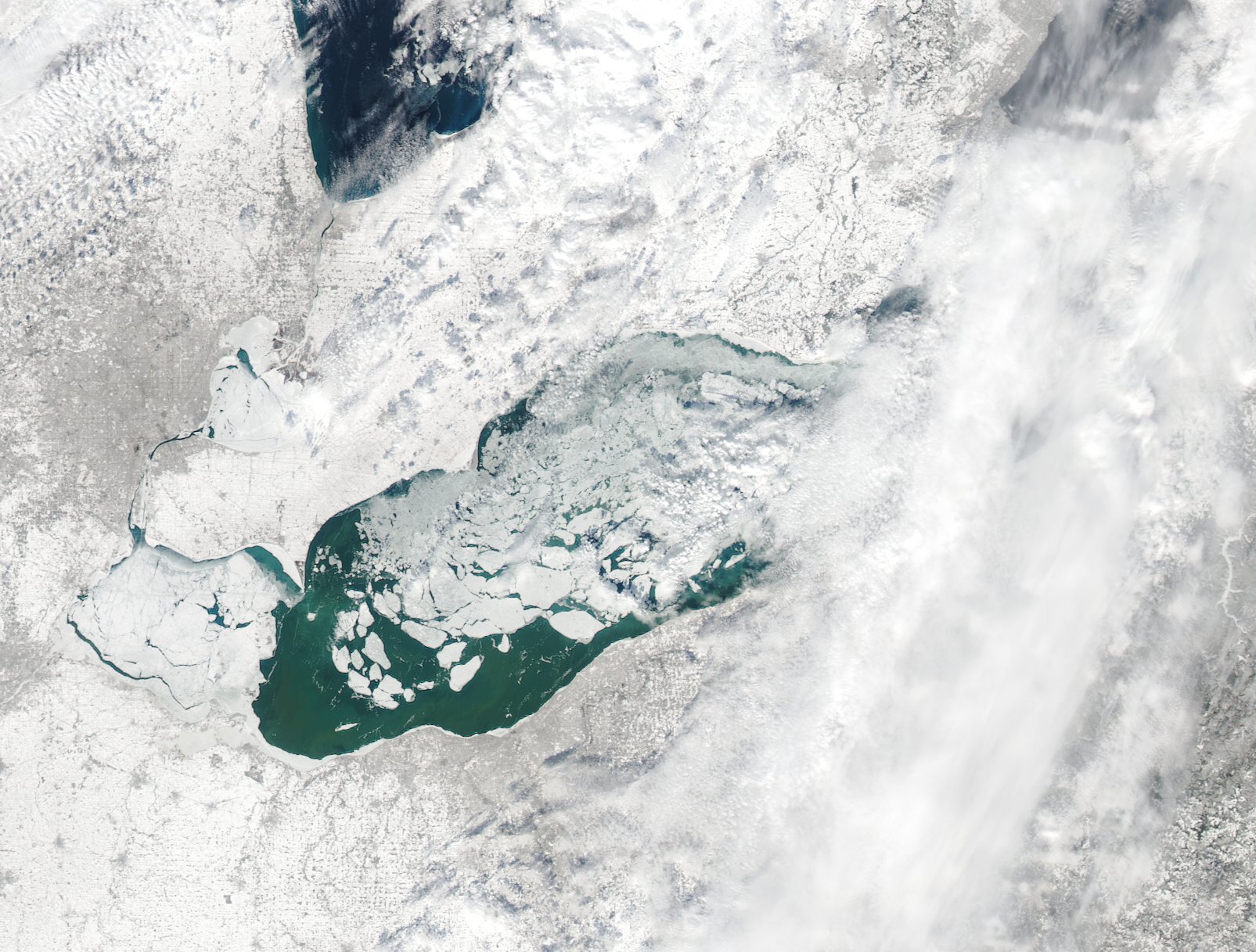
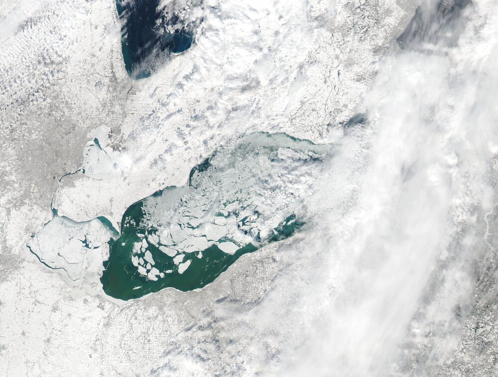
Just had a quick shower of light mixed stuff with the front earlier today...still not cold enough for a lake response yet and there was a drier wedge of air right behind the front, but it should get cold enough for minor lake effect to develop this afternoon into tonight into the primary snowbelt with a largely west flow. Think a dusting to locally 2" is possible later this afternoon through this evening, focusing on the higher terrain of the primary snowbelt. I'm still rather intrigued by Sunday afternoon and evening...getting a few glimpses at the central basin through the clouds this morning and it's more open than the above image. Actually looks like little ice east of the islands in the central basin. With plenty of synoptic support Sunday afternoon and evening and a light W/SW flow initially turning more NW Sunday evening, expect lake effect to develop over the lake and near the central lakeshore and then push inland Sunday evening. I still think the amount of instability and synoptic support may support decent accumulations, perhaps enough to warrant an advisory or even close to warning somewhere on either side of Cuyahoga County. The RGEM and Euro are picking up on this somewhat...the NAM is getting closer. Most hi-res models still aren't properly handling temperatures over the lake though (colder than the surrounding land). My main question is where it sets up with a rather light flow, but expecting it to focus on the largest area of open water in the central basin and then push southeast Sunday evening as the flow goes more NW, before focusing back up the eastern lakeshore into Monday as the flow turns westerly.
-
Suspect this weekend will be sneakily snowy downwind of Lake Erie...cold front moves through early Saturday with some snow showers. Suspect that mainly light but also very fluffy lake effect flares up Saturday into Saturday evening as 850mb temperatures drop below -15C, with enough lingering synoptic moisture to help the situation. Seems like any lake effect Saturday - Saturday evening will be pretty low-topped, but temperature profiles will favor very good snow growth by the afternoon and evening. With a fairly light WNW flow, could see a few bands from Cuyahoga County into the primary Snowbelt. Feel like a general 1-3" is likely between the front and lake effect late Friday night through Saturday night, could locally be a bit more if some organized bands develop. Sunday afternoon through early Monday would probably be a honking lake effect set-up if the lake were wide open with a very nice upper level trough moving right overhead. Even as it is, there's really good synoptic support for a time late Sunday into Sunday night with a light west-northwest flow and 850mb temperatures near -20C. Inversion heights look to rise to 8-10k feet with some synoptic moisture and perhaps some upstream connections. The light flow may favor mesolow formation over the lake and may also suggest the heaviest snow falling closer to the shoreline than normal, with temperature profiles again suggesting very fluffy snow. I suspect models are underdoing moisture flux and hence QPF as there's plenty of wide open water east of the islands and off of Cleveland, with the rest of the lake mainly ice covered but with plenty of cracks. The strong southerly winds through Friday will help push that ice around some more. The synoptic set-up would scream warning criteria snow Sunday afternoon through Monday morning in the Cleveland area and parts of the Snowbelt with a completely open lake. Even as it is, I suspect someone may get a surprising amount of fluffy snow out of it.
-
Lake effect surprised last night…2” in Reminderville but have a couple spotter reports out east of 4”
-
Your analysis of the radar starting to fall apart was spot on. Lighter snow lingered for a while, but the heavier stuff was on its way out. There aren't any dumb questions in this field! They came in with a 9.5" storm total...which I think is slightly low, but within reason. That depth in the daily climate report is the 7 AM number and they were up to 10" this morning. Blowing/drifting caused a lot of issues with measuring and caused the snow on the ground to start compacting last night. We had some public obs of 15"+ when all surrounding obs were more like 10-13"...those reports didn't get sent out, but did send out a number of LSRs from the public/social media of believable amounts near or just over a foot...on the other hand I do think some measurements came in low due to snow blowing away/compacting, anything under 8" in our area is too low. We will hopefully add up all of the 12 hourly spotter obs tomorrow and send those in a PNS. Best guess here was a little under a foot when I left this morning with about an inch additional since...so, close to a foot here. Another good synoptic storm in the books! Roads were still trashed early this morning with little traffic but still a few slide offs on 480, but quickly improved towards midday.
-
The last slug of heavy stuff is going to exit the next couple of hours. It'll be light the rest of the night. Think probably another 2-3" left most spots (maybe 4" far eastern OH into PA, and more like 1" or less in NW OH).
-
Hopefully you properly splurged and got the GT2 as well. I have a 2022 GT2 AWD and they managed to upsell me on the Scorpion addition because I was having a pre mid-life crisis in NJ and wanted the car. The Ford Fusion I had for a few years before this was a perfectly fine car but this is by far the best car I’ve owned…and how it performed today was a pleasant surprise. Guessing AWD and 2022 technology FTW. Beyond that, had about 2” this morning when I left at 7am. Took a few half hearted measurements and think I’m near 8” now…about 6” in the last 12 feels right. Some blowing and drifting. After getting the pack down to several dense inches yesterday it’s deep out there again.