OHweather
-
Posts
5,046 -
Joined
-
Last visited
Content Type
Profiles
Blogs
Forums
American Weather
Media Demo
Store
Gallery
Everything posted by OHweather
-
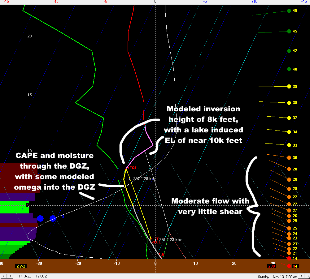
With winds in the 280-290 range for a good period of time late tonight into Sunday morning and signs of good convergence from Cuyahoga into Geauga County, definitely would not surprise me if those in NEOH/dta land end up with a few inches of snow by some point Sunday morning. Pretty consistent signs on guidance that a fairly intense band will come in across Cuyahoga and Geauga later tonight...question is exactly how far north/south it sets up. The flow is quite well-aligned at 20-25 knots, which is pretty optimal for organized banding, with some synoptic moisture and lift from the shortwave going by. Instability still looks solidly moderate to nearly extreme, with EL heights of up to 10k feet at times. The limiting factors remain the fairly short duration, mild air/ground temperatures, and modest snow ratios, but a few dense inches of accumulation seems reasonable if a band sets up for any length of time given the other favorable factors. Some mood flakes ongoing right now here.
-
Winter 2022/23 Short/Medium Range Discussion
OHweather replied to Chicago Storm's topic in Lakes/Ohio Valley
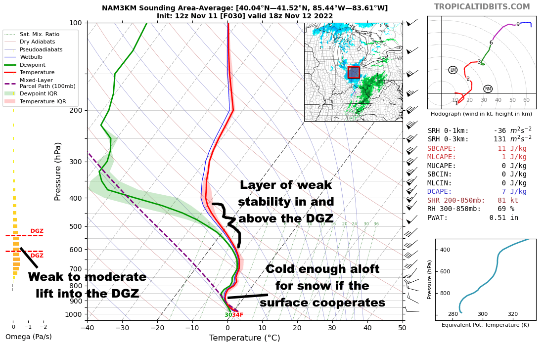
I didn't have 6" of snow on my bingo card for this system...there is small band of mid-level fgen driving the heavier snow, and it is producing its strongest lift in the DGZ so you're getting ratio help. Pretty impressive for the Ohio Valley in the first half of November. -
Some Thoughts On The Next Couple Months
OHweather replied to OHweather's topic in Weather Forecasting and Discussion
You are little more unique in that you're much more dependent on the sub-tropical jet or cut-off lows for temperatures than a lot of the rest of the U.S...but, I'll be curious to see how the pattern evolves into December. I think we're on a similar page for the next couple of weeks, but I'm more bullish on a -EPO (and perhaps a more workable AO and NAO) returning in December. The WPO is probably going to be slightly negative for this month, or at worst near neutral. It was weakly neutral the first week of the month, is briefly positive now, and looks to trend more negative again for the next 10 or so days. I left WeatherWorks on good terms late in 2021 and am not too unhappy about not having to deal with a winter outlook for my job this year, so they can have at it with theirs! Thanks for your input, Matt! Many interesting points you raise here. I also am unsure of how old teleconnections or rules of thumb hold up given the influence of climate change. I still think analogs and composites have some use when looking ahead, but you need to mentally adjust for the influence of climate change...which I'm personally still not sure what the influence is...I think it adds another difficulty in long range forecasting. We have seen two odd QBO progressions over the last several years after not really seeing anything like that before, so it is curious to see if that continues happening going forward. It's possible the super El Nino in 2015-16 had at least something to do with that. Good point that in North America we can get cold from a favorable Pacific even with a lackluster AO/NAO, whereas Europe very much needs the AO and NAO to cooperate. The persistent Scandinavian block you mentioned that's modeled over the next couple of weeks is intriguing for a couple of reasons...it may help cool off eastern Asia, allowing for increased mountain torque down the road, and may have a shot at retrograding towards a -NAO as well. If this aligns with the MJO moving back into the western Pacific in late November, perhaps that's the evolution we need to shake the +NAO? I'll believe it when I see it at this point, but there's reason to be hopeful for the NAO dropping around the end of November or early December. If we see La Nina and its associated western Pacific uplift last through the winter, I agree that'd point to an increasing risk of a +NAO and mild weather as the winter goes on, especially if we don't see a SSW. I do wonder if the MJO activity we've seen this fall is an indication that La Nina is beginning to lose its grip...if that's the case and we see the MJO occasionally work across the Pacific at a decent amplitude through the winter, perhaps we mitigate any mid-late winter warm spells a bit. I'm not sure yet which way we go with the stratosphere, but as you mentioned it's not coupling to the troposphere for now even though the strat PV is a on the strong side for this early in the season. Perhaps we can see a brief weakening of the stratospheric PV around the end of November/beginning of December if we see a Scandinavian block and Aleutian low at the same time, though the pattern doesn't scream for anything major yet. Thanks for the added conversation! I remain fairly confident that the general idea for the next few weeks is on track for the reasons you touched on with the MJO. There are also signs that we may see increased mountain torque again later this month, which would support the EPO and PNA improving again and could also help kick the MJO east of the Maritimes if it tries getting stuck there...which would be a similar evolution to what we just saw early this month. How the stratosphere plays out may have something to say about the rest of the winter, and may even have something to say about if blocking does return to end this month or into December. I agree with you (and Matt) that right now, it's hard to glean much from the stratosphere...I could see another brief stretching event of the strat PV around the changing of the months, but otherwise the strat PV is fairly strong but isn't yet coupling to the troposphere in a problematic way. -
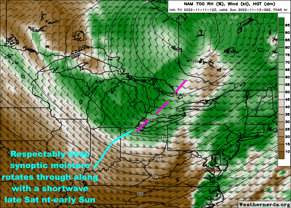
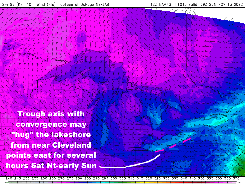
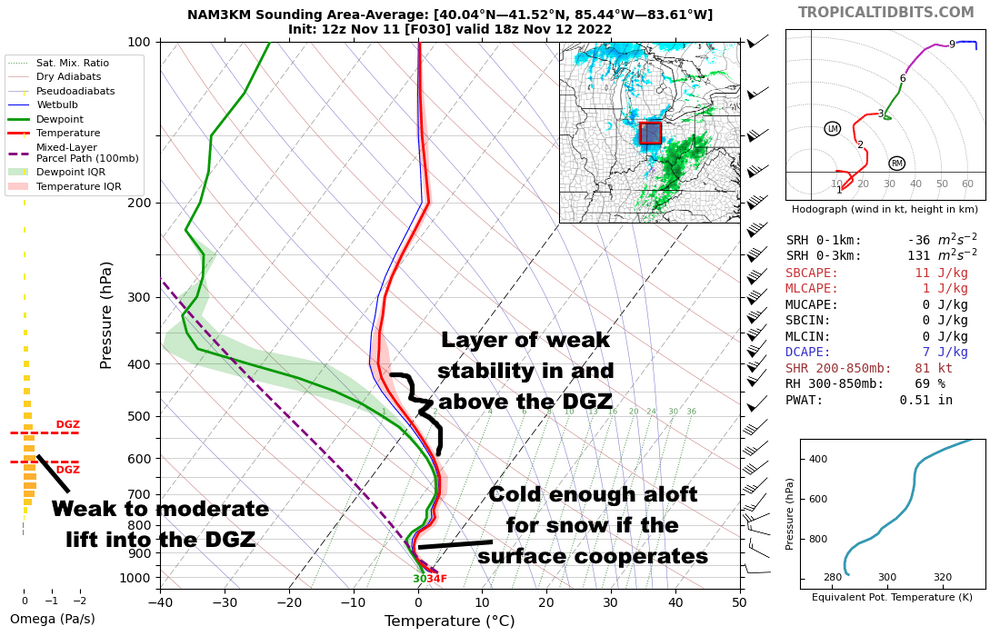
Definitely a taste of winter arriving this weekend and lingering through at least next weekend. A shot for some flakes Saturday afternoon as a shortwave brings some light precipitation to the area, though surface temperatures are marginal so probably no chance to stick, and this may simply be mainly rain along the lakeshore. The lake effect set-up Saturday night into Sunday is interesting...a mix of pros and cons...there is briefly good synoptic support with a shortwave, surface trough, and increased moisture pushing across the lake and into the primary snowbelt overnight Saturday night into early Sunday. Expect good convergence near the shoreline from Cuyahoga County points east for several hours Saturday night into early Sunday. At the same time, instability is moderate to nearly extreme off the lake, per BUFKIT, with a very well-aligned flow out of the west-northwest and inversion heights climbing to close to 10k feet. The profiles are too warm for a good fluffy snow, but expect precip off the lake to change to snow fairly quickly in the hills Saturday evening (if it even rains in the hills at all) and eventually change to mainly snow or graupel even close to the lake by Sunday morning with 850mb temps of -8 to -10C. Locations away from the lake should drop to near, or in the higher terrain just below, freezing Saturday night which will allow the snow to stick if it comes down steadily at all. Along the lakeshore probably stays in the mid to upper 30s, which will limit accumulations there a good bit. The set-up is short duration, with winds turning more solidly WNW into Sunday, likely causing any bands to lose some organization, especially by midday as air temperatures over land start warming up a bit and weaken any lingering convergence near the lakeshore. Pros: Decent synoptic support/moisture, good instability/decent inversion heights, shoreline convergence favoring focused bands, very little shear Cons: Warm ground and marginal surface temperatures, especially near the lake but even inland initially, modest snow ratios, and fairly short duration with winds gradually shifting through the event I think the winds go west-northwest enough that we can see a band develop and hug the Cuyahoga County lakeshore and push east into the eastern suburbs and a good portion of Geauga County, especially towards early Sunday. There's often another band or two that gets into eastern Ashtabula County and Erie County PA in this type of flow. If we do see bands develop in those locations, snow should be intense enough that it could accumulate up to a few inches in the hills, so it wouldn't 100% shock me if eventually an advisory is needed (I am off this weekend so this is not "inside knowledge", just me spit balling)...however, given the limiting factors, anything more than locally a few inches seems difficult, and even the few inches will depend on organized bands developing for at least a few hours.

-
Winter 2022/23 Short/Medium Range Discussion
OHweather replied to Chicago Storm's topic in Lakes/Ohio Valley
Kind of came out of no where, but a nice negatively tilted shortwave and the lift ahead of it will try to product some snow late tonight through Saturday as it lifts through the Ohio Valley and into the eastern Great Lakes. The lift isn't crazy but it's there, and the somewhat steep lapse rates in and above the DGZ may help some briefly more moderate pockets of precip develop. The main issue, especially farther south/east and especially as we head into the afternoon, will be marginal boundary layer temps, but a good shot many from southern MO/northern AR into southern IL, southern/eastern IN, northern/western KY, and a good portion of OH at least sees flakes out of this late tonight and tomorrow.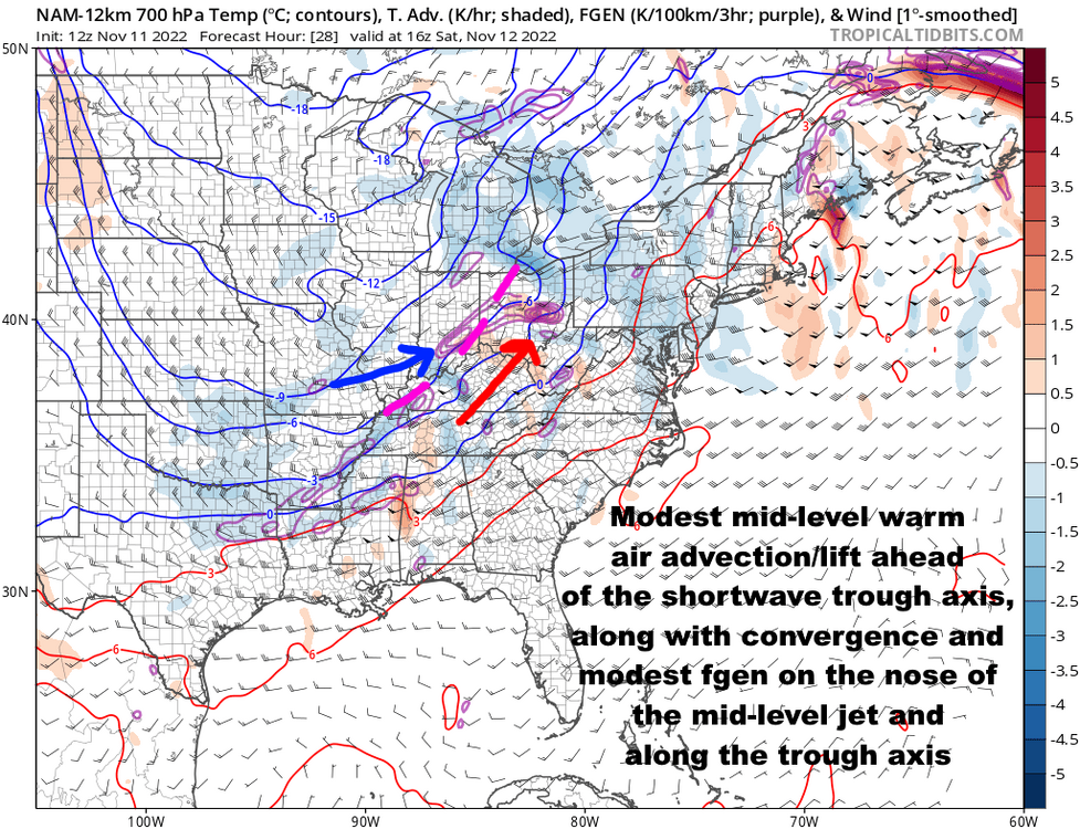

.thumb.gif.ce2539ecef230ddaa13771b60f4a85be.gif)
-
It looks like a mediocre lake effect set-up Saturday night through Sunday, perhaps lingering into Sunday night. I could see some spots getting a few inches, but it may be more of a due west or slightly west-southwest flow that keeps things more confined to the I-90 corridor from Lake County points east. But, seems like a chilly couple of weeks so there may be more chances, and I'm still optimistic about December.
-
Some Thoughts On The Next Couple Months
OHweather replied to OHweather's topic in Weather Forecasting and Discussion
Thanks for your insight as always. I do see your point of contention with 1996-97, as this will not be going towards any kind of a strong, east-based El Nino anytime soon. That said, the La Nina is starting to lose its grip, evidenced by the MJO activity we are starting to see, so that's why I think it may be somewhat useful as an analog. I am curious to see how this month looks when it's in the books...while the early month heat is indeed very impressive in the east, and will be hard to overcome on the monthly mean, the rest of the month will be much colder in the central and eastern U.S...many of the years you mentioned were chilly/cold in the west and anywhere from mild to very warm over the east in November, with a large +EPO/trough over Alaska. While this month is starting mild, we're really avoiding that ++EPO look, and probably will have a negative EPO for the month of November overall. So, I'm curious to see if that leads to my colder December idea still having a shot when the analogs you mentioned are much bleaker for the east (but are somewhat more interesting for the west). If we see another strong MJO event to end this month and into early December, I'd be rather surprised to see any kind of +EPO stick around for long, even if it does briefly flip positive after Thanksgiving. -
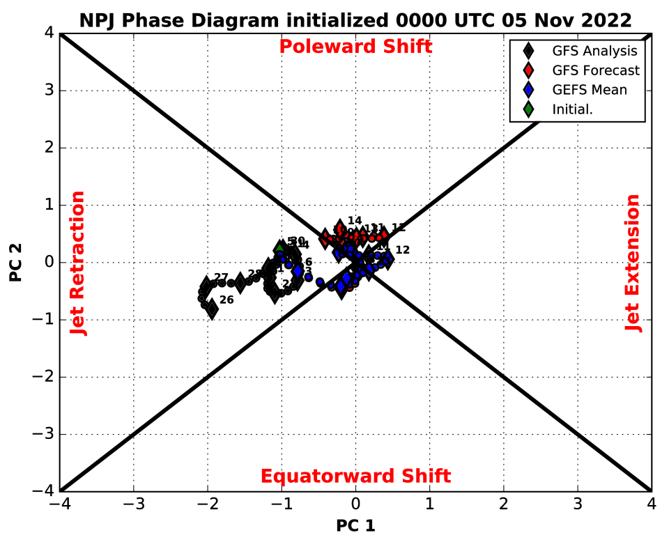
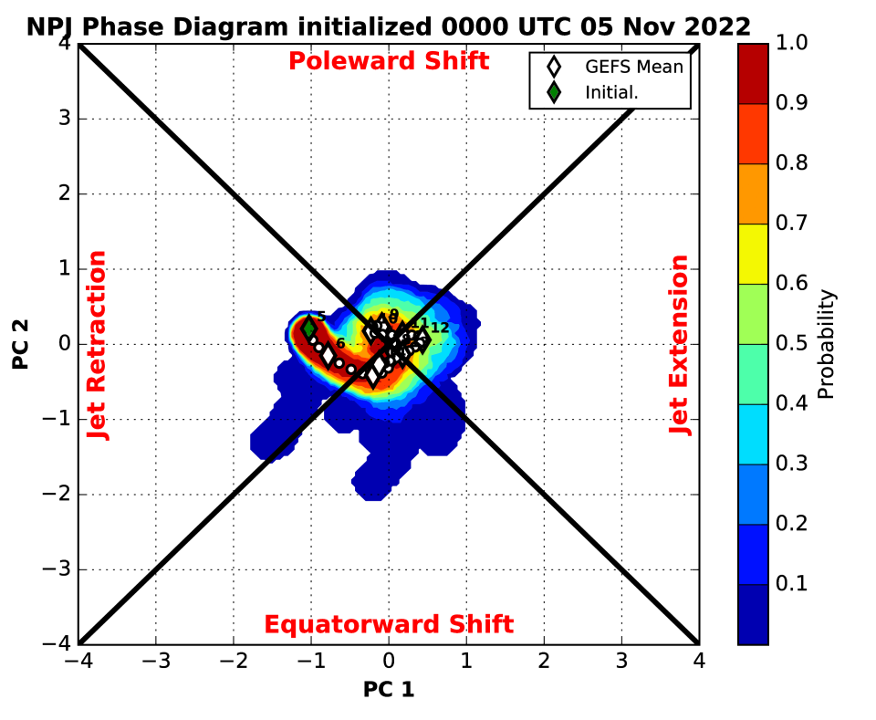
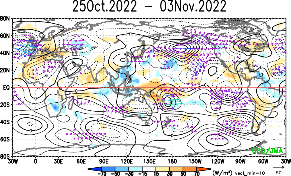
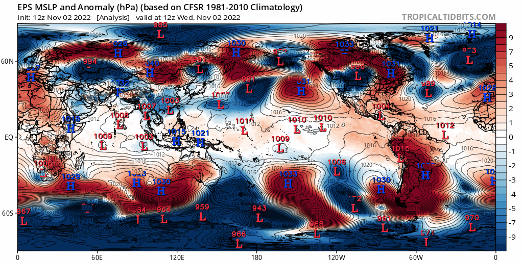
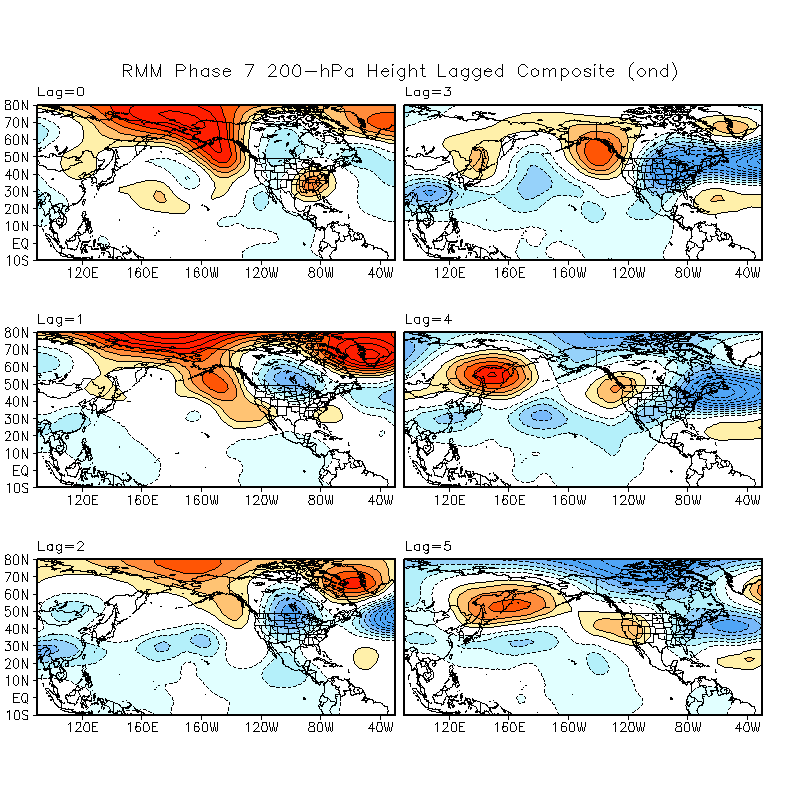
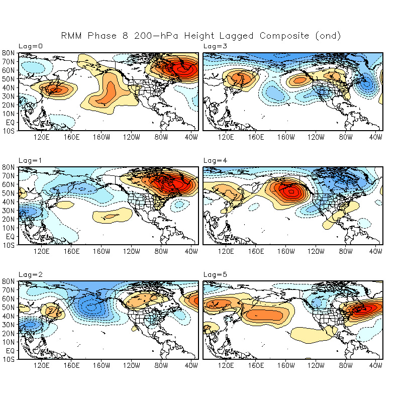
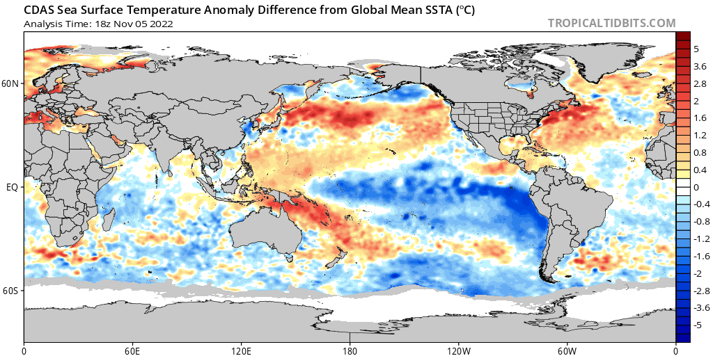
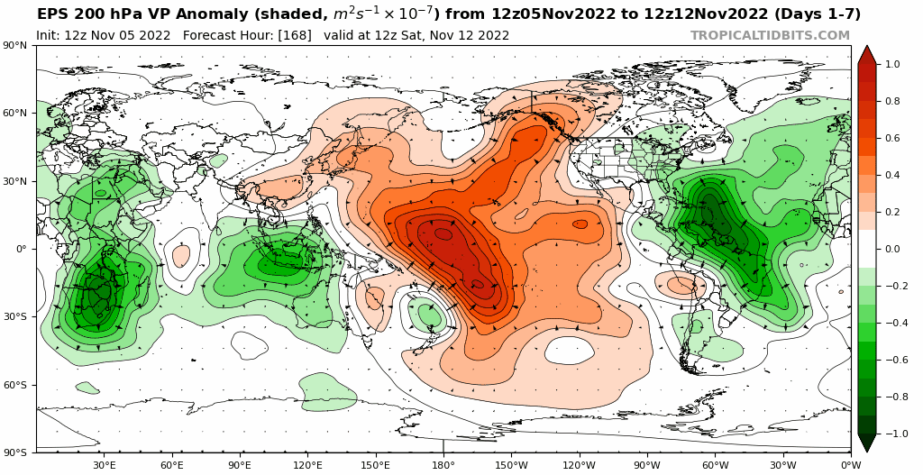
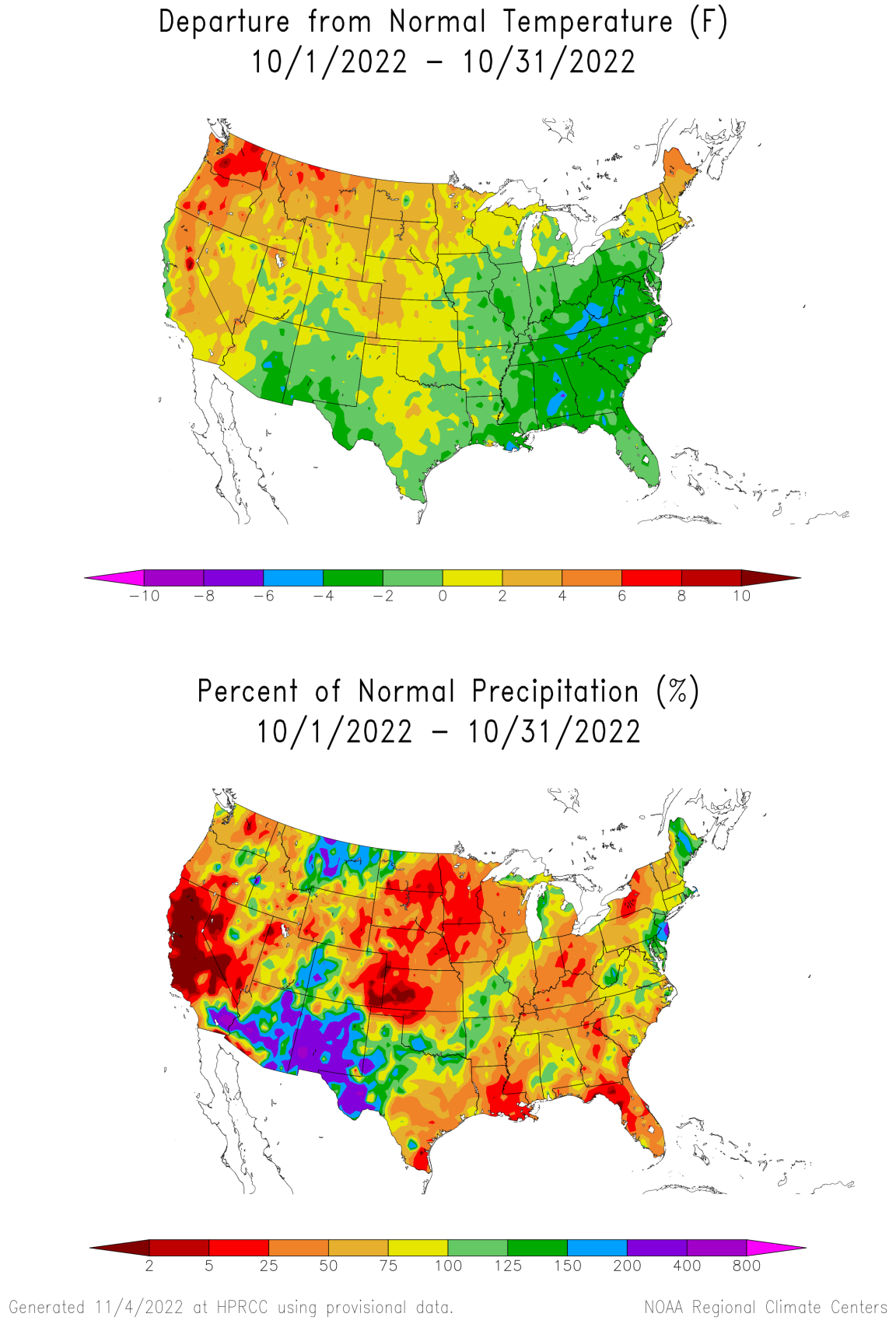
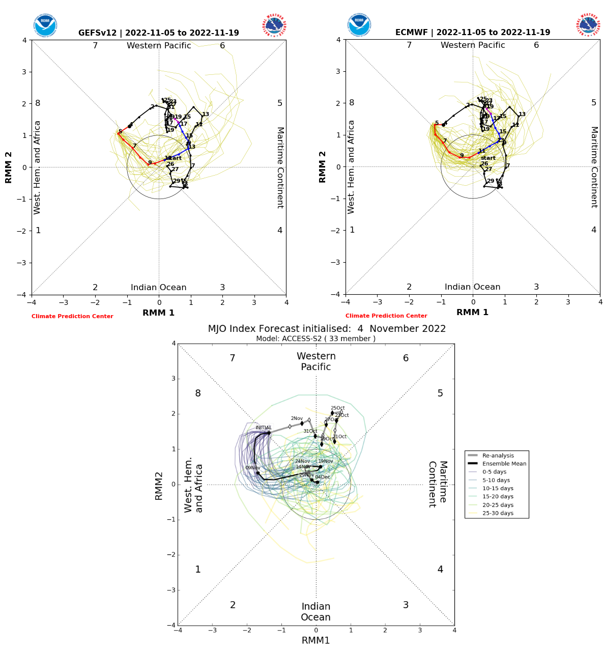
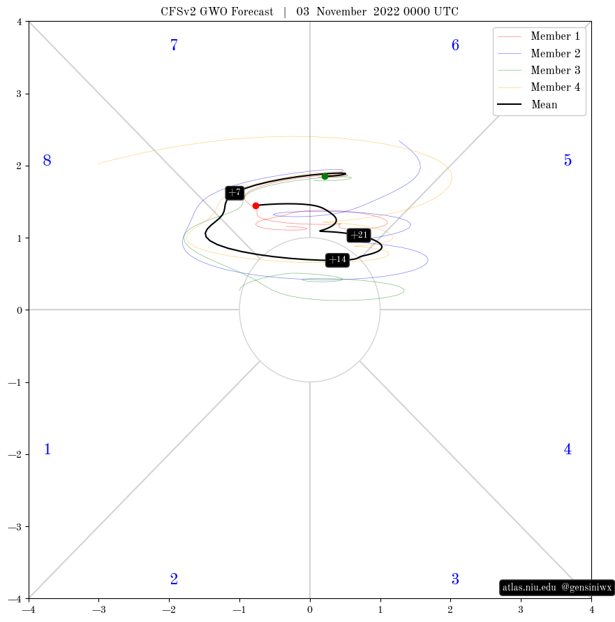
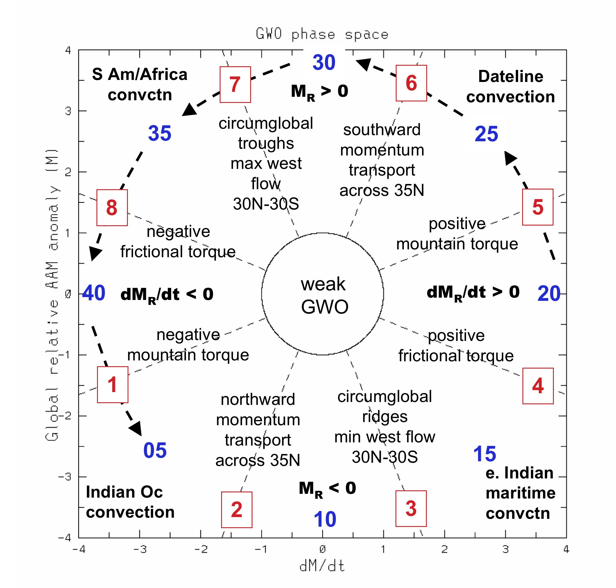
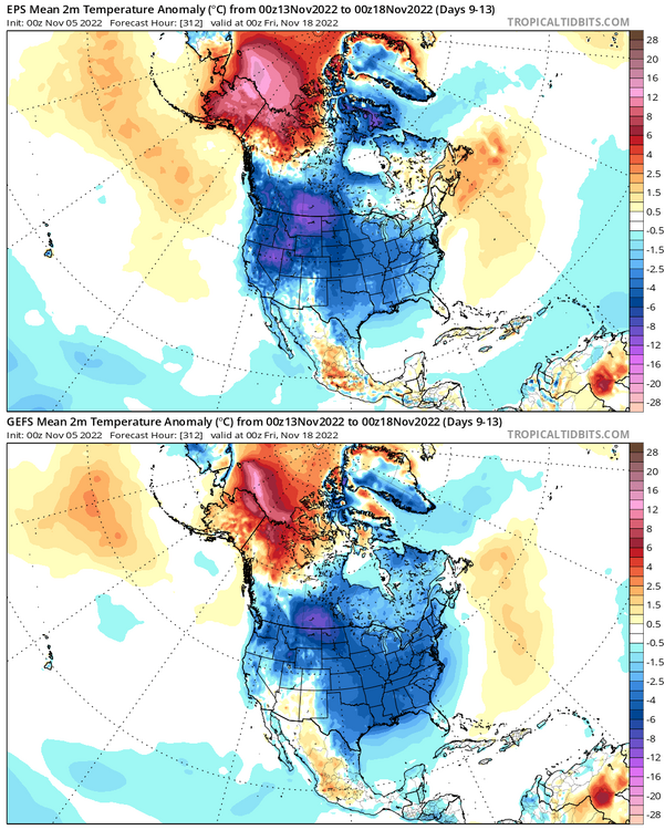
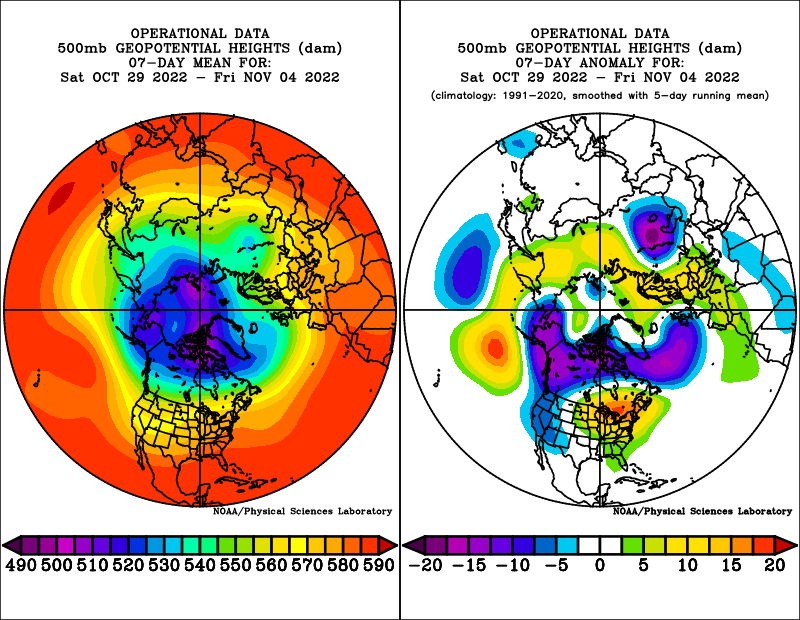
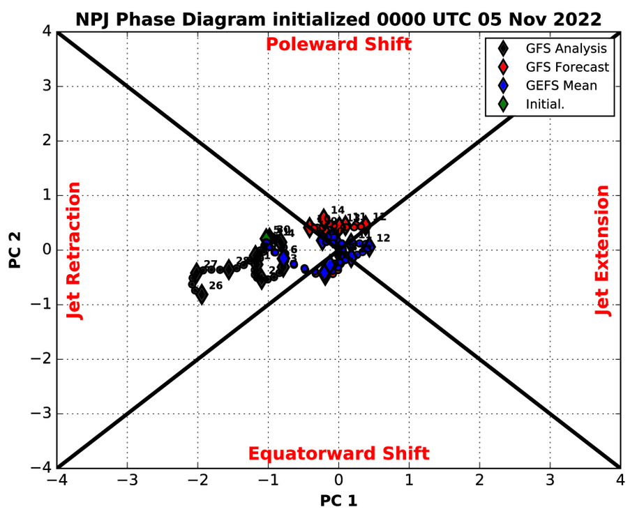
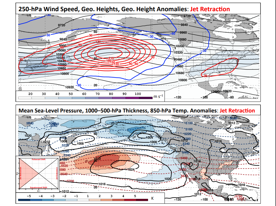
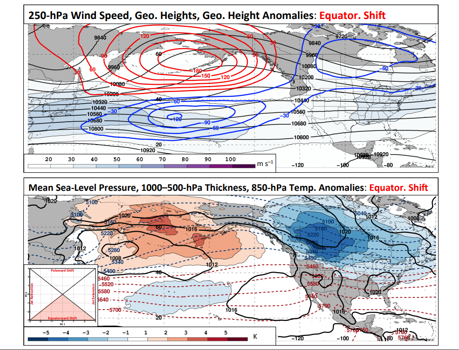
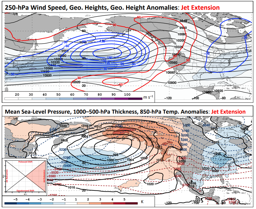
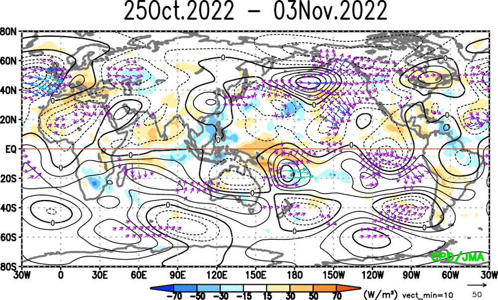
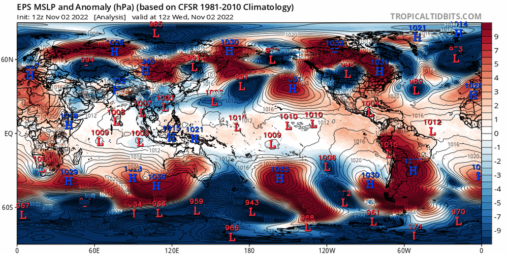
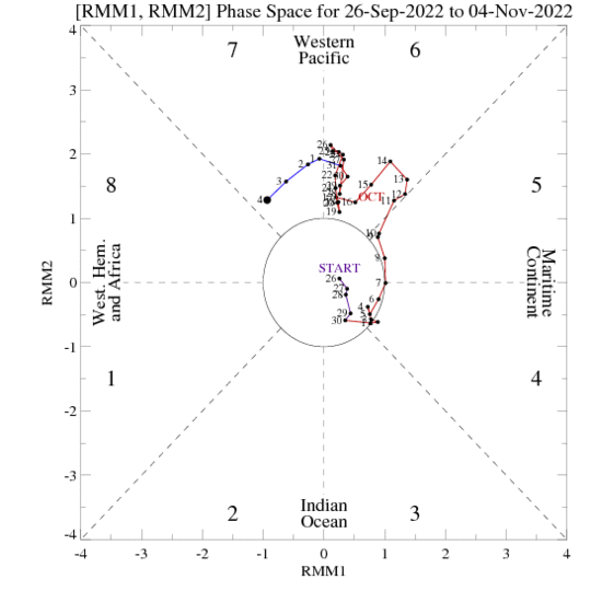
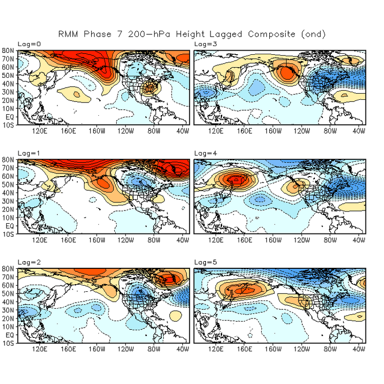
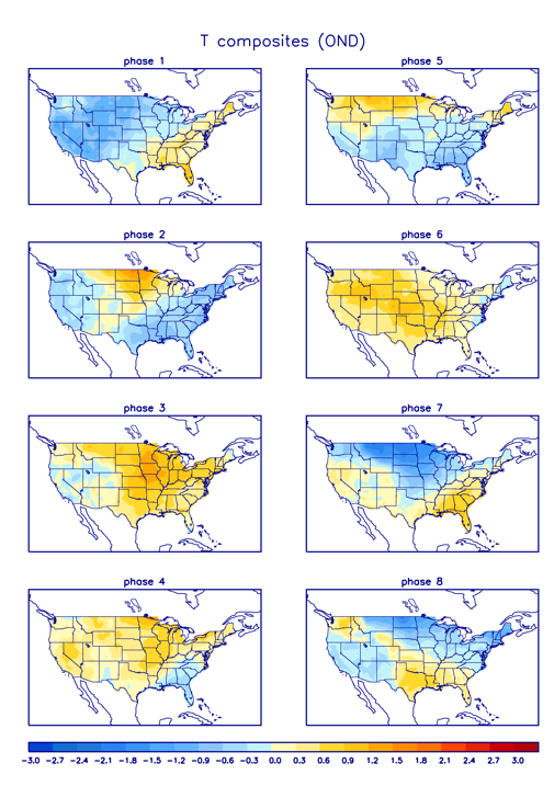
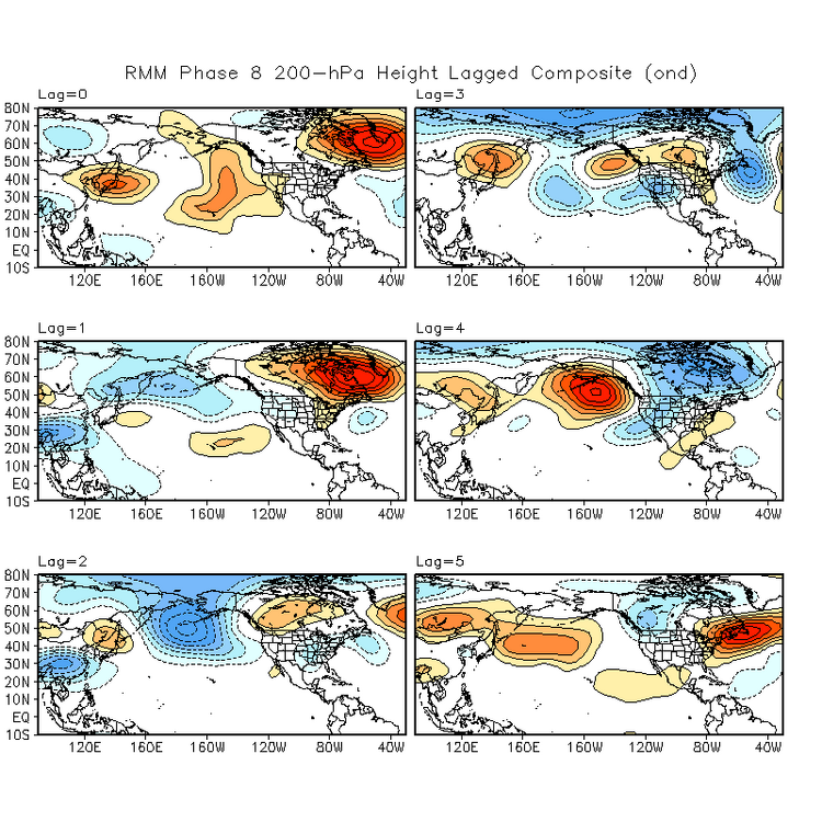
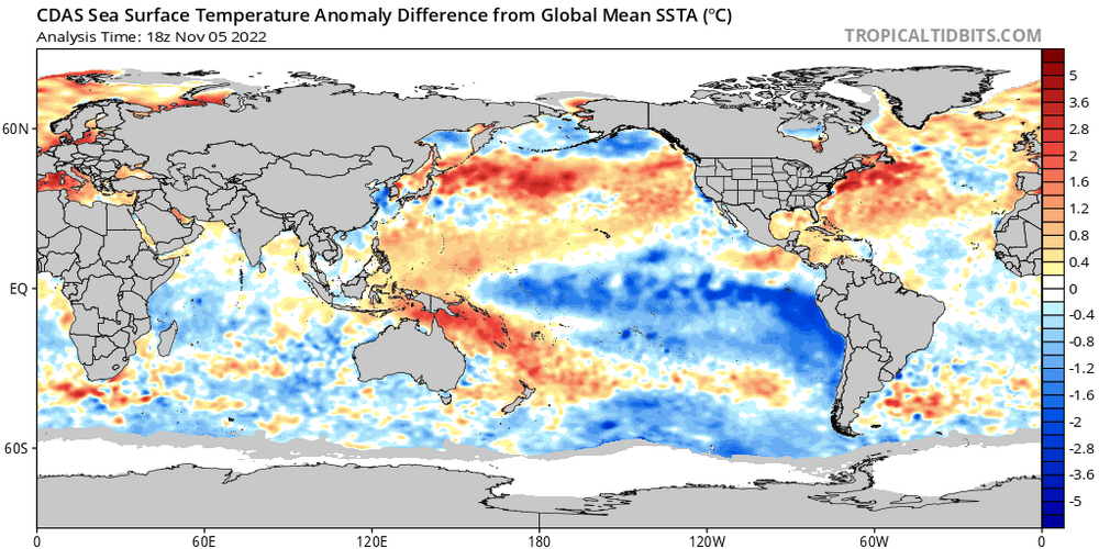
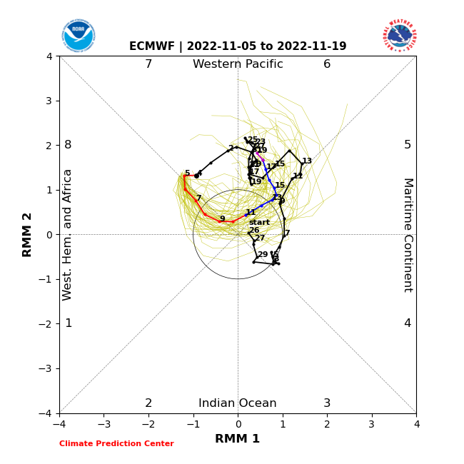
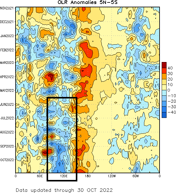
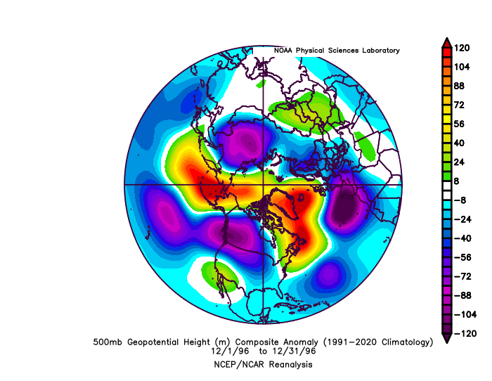
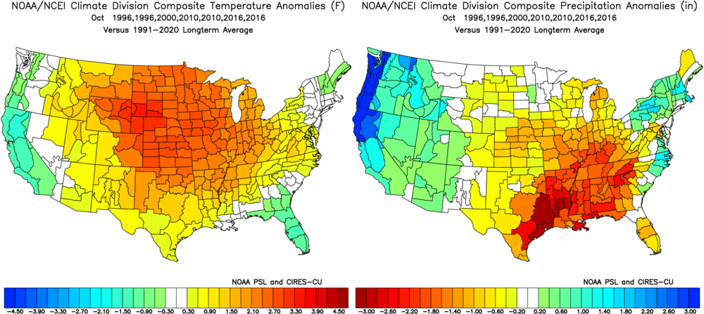
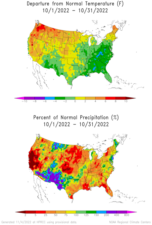
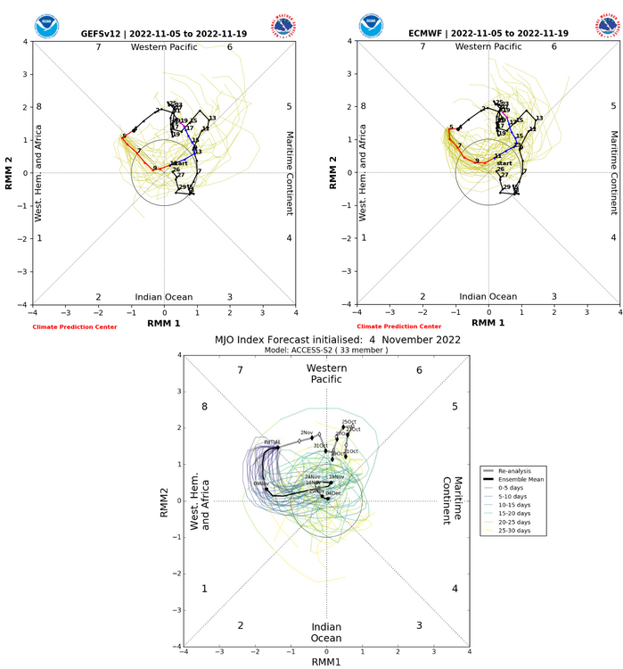
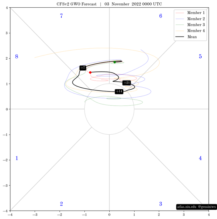
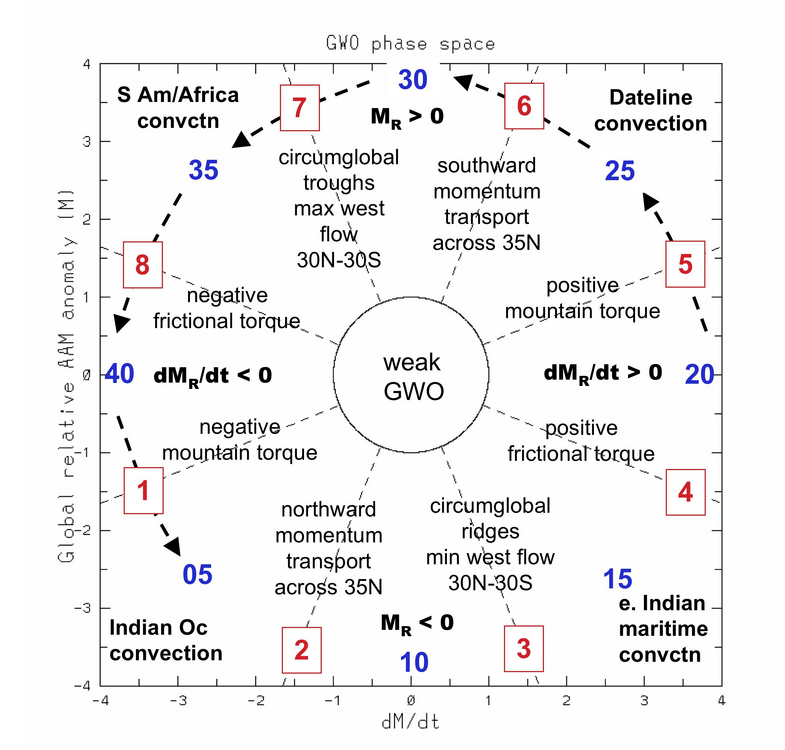
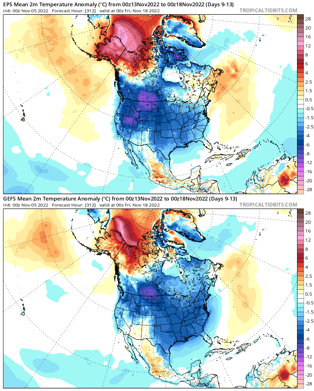
Not a "winter forecast" per say, more like a sh*tload of speculation about the pattern through the first ~half of winter... The Key Points Up Front: The pattern of “cold west, warm east” continues through most of this week Later this week into this weekend, cold spills into the central and eastern United States. The pattern then remains fairly chilly across the Lower 48 for a couple of weeks, with the coldest overall conditions across the northern Rockies and northern Plains Several signs point towards the weather pattern in much of the continental United States trending mild yet again towards the end of November and early December A few analogs and early signs in extended guidance suggest the potential for increased high-latitude blocking and colder weather may return into December. Given the ongoing La Nina and -PDO, confidence in this occurring isn’t high yet. However, the coldest December since at least 2016 is distinctly possible if things align properly The Details: After a very chilly first half of October, which was enough to plunge most of the eastern U.S. to below normal values for the entirety of the month, mild weather has dominated the pattern over much of the central and eastern U.S…this pattern continues into this upcoming week, but the GFS and Euro ensembles both indicate below average temperatures over fairly decent stretch for almost the entire CONUS closer to mid-month: It’s getting to be the time of year where colder anomalies have some more bite and can start bringing snow to more of southern Canada and the Lower 48. This cooldown has trended more and impressive as it moves up in time on the models, evidence by this GFS ensemble trend loop for the same time period: After such a prolonged mild spell, is this cooldown shown in the medium to long range feasible, and how long may it last? Looking at a few things, including the character of the Pacific jet stream and the MJO, suggests that the projected cooldown on the ensembles has legitimacy. Let’s start with the pattern over the last week leading up to Friday: The pattern is undoubtedly a warm one for the central and eastern CONUS and into southeastern Canada, with a positive AO (PV generally tight and confined to the high latitudes), a very positive EPO (the trough over Alaska and western Canada), a negative PNA (Aleutian ridge and West Coast trough), and positive NAO (trough over the north Atlantic). The above pattern correlates very nicely to the expected pattern when the Pacific jet is retracted, as it has been most of late October and very early November per the above chart: The flat ridge south of the Aleutians, trough over Alaska and western Canada/the western US, and downstream ridge over the eastern US are quite characteristic. There are a couple of ways to analyze how the Pacific jet is progged to behave on current guidance over the next week or so…one is just to throw in a loop of ensemble mean forecast 250mb winds: We start off in the middle of last week with a “jet retraction” look, with the jet barely extending off of Asia and a ridge over the Aleutians, directing the jet stream towards Alaska and the northwest coast of North America, helping facilitate the current very mild pattern across a good portion of the Lower 48. However, quite a bit of westerly momentum is getting added as I type this and into early this week. Initially, the ridge near the Aleutians just amplifies and disperses a lot of this added momentum around it, but eventually the jet extends and pushes the now-amplified ridge east, facilitating cross-polar flow into North America and really cutting off the Pacific influence by this upcoming weekend. Here is the GEFS forecast Pacific jet character: A similar trend, from a pronounced jet retraction in late October towards neutral, with perhaps some modest lean towards an equatorward shift or jet extension over the next week or so. Here are what a Pacific jet extension or equatorward shift tend to look like: Note the trend towards much higher heights into the northern Pacific and Alaska, with resultant troughing and colder weather over a good portion of North America…in particular, over western and central Canada into the northern Rockies and Plains with an equatorward shift, but bleeding towards the East Coast. The equatorward shift looks more like a -EPO but still somewhat negative PNA, while the jet extension looks more like a classic +PNA with a somewhat negative EPO. This generally matches the ensemble’s forecast pattern over the next week or so: The impetus for this change seems to be a combination of increased east Asian mountain torque and tropical forcing working out of the eastern hemisphere and into the western hemisphere early this month. Initially, the pattern this weekend into the first half of the week simply looks like a significant amplification to the going pattern: At first, we just see the ridge south of the Aleutians amplify, which amplifies the downstream pattern over North America (western trough and eastern U.S. ridge). However, this very mild look over the eastern U.S. doesn’t last too much longer as the ridge amplifies into Alaska, forcing cold south towards the CONUS, and as an Aleutian low develops. An Aleutian low is a trend towards a more positive PNA. Note positive MSLP anomalies (high pressure) dropping into eastern Asia right around now, signifying a significant increase in east Asian mountain torque, which results in added westerly momentum to the east Asian-Pacific jet. There may be another push later this upcoming week, before a fairly well agreed upon trend towards a much more negative east Asian mountain torque into mid-November: Positive East Asian mountain torque tends to result in an extension of the Pacific jet and subsequent rise in the PNA, as the extended jet and associated left-exit region towards the north-central Pacific tends to favor low pressure over the northwest Pacific or Aleutians and subsequent height rises to the east closer to the West Coast of North America. At the same time, the MJO has come out of the Maritimes and into the western Pacific at a fairly high amplitude, and is now quickly working into the western hemisphere. The satellite/VP anomaly loops over the last two weeks show a similar trend as the above RMM plot, with strong uplift over the western Pacific until the end of October quickly shifting east. Note how areas that had the strongest upward motion (~120E) at the beginning of the loop have strong sinking motion now, and vice versa over portions of the central and eastern Pacific. Clearly, the tropical forcing is changing from the forcing that led into our current very mild pattern. After a decent Phase 7 passage, an increase in blocking near Alaska in October-December is quite common: We are not going to get the NAO help in the short term, but blocking located near Alaska/a -EPO is often common during and following a phase 7 MJO this time of year as seen above. The MJO is about to briefly get into Phase 8, which also often leads to a colder outcome into the southern and eastern U.S. than a Phase 6-7 in the fall: And for what it’s worth, the same October-December lagged composites from the CPC for a phase 8 MJO, which is briefly occurring right now: The issue with these is that the pattern right now into this week, which would be a “Lag=0” for the current phase 8 RMM indication, is that the NAO is quite positive with a deep trough out west. That said, a phase 8 MJO this time of year often corresponds to immediate and short term blocking, with an Aleutian low/+PNA and colder trend over most of North America. This is then followed by the PNA trending more negative and blocking generally breaking down within a few weeks of the phase 8 MJO occurring. Despite the phase 8 MJO pointing to a -NAO, I am fairly confident it will remain positive for the next 10-15 days. This is because the stratospheric PV, while getting stretched a bit at times, is going to remain on the stronger side of normal, which argues towards a +NAO for now. In addition, recall back to this EPS mean sea level pressure/anomaly loop: Note multiple high pressure systems dropping in just east of the Rockies over the next 10 days. The Rockies are not quite as tall as the Himalayas, but they’re still plenty tall enough to produce a mountain torque that requires increased momentum in the jet stream to conserve angular momentum in this equation (the positive mountain torque removes momentum by slowing Earth’s rotation slightly). This speeds up the jet over the eastern U.S. into the North Atlantic, encouraging positive NAO trends. Given that the NAO has been positive since late October, I don’t see it flipping negative in the face of this through at least the middle of November. Looking Beyond Mid-November: A dramatic shift to a colder pattern in the CONUS, first into the Pacific Northwest over the next few days and then expanding into the rest of the CONUS through next weekend and through mid-November is agreed upon by the major ensembles and seems very well-supported by various forcing mechanisms…driven by a plunging EPO and rising PNA. But how long will it last, and does it mean shit for the approaching winter season as a whole? To answer the first part of this question, we will examine things such as mountain torque and tropical forcing yet again. Starting with mountain torque, and picking up closer to mid-November, after our upcoming increase in mountain torque and injection of westerly momentum into the Pacific jet: Positive east Asian mountain torque is ongoing at the start of the loop, but as low pressure develops over much of southeast Asia, this becomes negative, reducing westerly momentum into the Asian-Pacific jet around mid-November. This suggests the jet will have a tendency to retract again, which would render the upcoming PNA spike brief and could eventually cause the EPO to start trending more positive again. Remember, we are in a La Nina with a solid -PDO, evidenced by the cool tongue across the equatorial Pacific, the warm waters over the northwest Pacific, and the cool waters south of Alaska: These both favor a -PNA and often favor a predominantly +EPO as well. We look to buck that over the next week due to tropical forcing progressing through the Pacific and Western Hemisphere and due to a positive east Asian mountain torque, but when those shorter term pattern drivers subside, the lower frequency forcing can often dominate yet again. So, the expected negative east Asian mountain torque towards mid-November is a signal that a more -PNA and more neutral EPO is a distinct risk into the latter portions of November given the background forcing. Most guidance (the European ensemble shown above) suggests tropical forcing quickly progressing through the western hemisphere over the next week or so, with eastern hemispheric forcing (in particular, over the eastern Indian/western Pacific oceans) becoming dominant once again towards the second half of November. Given the background state, this seems very plausible after the current higher frequency forcing moves through the western hemisphere in the shorter term. RMM forecast plots also indicate similar, with the ongoing Phase 8 MJO not lasting long and then becoming “indeterminant” (which usually means lower frequency forcing can exert more influence again). Thereafter, the MJO may move into phases 5 or 6 after the 15th. Here is the European ensemble forecast MJO progression through November 19th: Recalling back to the above October-December MJO phase temperature correlation plot above, phase 6 is quite mild in the CONUS. This general evolution (eastern Indian/western Pacific Ocean tropical forcing becoming dominant again into mid-November) is well agreed upon by various medium to long range forecast models/ensembles. In addition, the water temperatures support convection and tropical forcing wanting to favor this general region again, as does where enhanced convection/upward motion has been most persistent in recent months near the equator: So, the background pattern suggests a risk for a retracted Pacific jet and -PNA/+EPO to return when other shorter-duration forcing weakens. In addition, there’s fairly consistent indication that the shorter-duration forcing (mountain torque, MJO) will weaken and may in fact positively feedback with the “background” La Nina pattern into late November. There’s enough support for a significant cooldown that it will take some time for milder weather to return, we’ll probably have a full 1-2 weeks of generally cold conditions (for this early) across the CONUS. However, many indications are that milder weather gradually returns from west/southwest to northeast in the second half of November. In terms of snow potential over the next few weeks, the higher elevations over much of the western U.S. (outside of perhaps the Four Corners and southern California) will remain cold and active through this week with a -PNA and dropping EPO. As the cold ejects east late this week, a lee cyclone may bring snow potential to the northern Plains and Upper Midwest. Thereafter, it looks like a fairly dry EPO-induced cool/cold shot into the central and eastern CONUS. Not all hope is lost, as some snow may occur via lake effect, weak clippers, or perhaps any waves riding along the baroclinic zone if the sub-tropical jet isn’t totally quiet. Likely not a pattern that supports a widespread, major winter weather event (especially in November), but it’s possible some minor or localized snow events occur outside of the mountains starting this upcoming weekend and through roughly Thanksgiving. Some Fun With ENSO/MJO Analogs: The rest of the winter is not yet lost though. In fact, the findings discussed below are what prompted me to make this whole thing a post instead of a Tweet thread. I just thought “there’s a lot here, let’s try to tie it together better than intentionally cryptic Tweets would”. This much MJO activity in the fall leading into a La Nina isn’t too common. Since 1975, only 4 La Nina Novembers saw the MJO move into both phases 7 & 8 at an amplitude of greater than 1. Those are 1996, 2000, 2010 and 2016. Oh, there’s that fabled 2010-11 analog. We also have a very negative IOD and solidly westerly QBO. Let’s see if we can leverage those high-confidence, long-duration pattern drivers. We have a negative IOD this fall and will have a westerly/positive QBO through this winter, full stop. 2010 and 2016 had a westerly QBO 1996, 2010 and 2016 had a negative IOD How did those 4 years play out during December? All but 2010 had a solid -EPO, and 2010 still had very pronounced north Pacific ridging along with a a huge -NAO. All but 2016 had a -NAO. All but 2000 had a -PNA. All but 2016 had a -AO. Here is a look at the October-February monthly temperature and precipitation anomalies for these years (weighted slightly based on QBO/IOD matches): For reference, here are October’s temp/precip anomalies: Overall, the October pattern this year actually resembles those analogs, though with the pattern seemingly shifted west slightly. The very warm start to November likely dooms the eastern U.S. to finish with a somewhat mild overall month, but the pattern after this week may resemble these years in November fairly well. It’s at least in the ballpark enough that these analogs aren’t immediately invalid. I believe how the MJO and mountain torque play out during late November and into December will heavily influence if the potential for a very blocky, cold, active December comes to fruition given the risks for a milder pattern (at least temporarily) returning by the end of November. Just looking at some various products, the EPS (already shown), GEFS, and Australian BOM MJO forecasts: The GFS/Euro both have the MJO strongly and definitively progressing through phase 6 and towards phase 7 into late November. This could be indicative of a similar angular momentum/global wind oscillation orbit to what we are currently seeing, as per this CFS forecast: An orbit through phases 5-7 (as has recently occurred) supports convection moving east towards the Dateline and eventually the western hemisphere, along with positive mountain torque and troughiness into the mid-latitudes: With that said, we are fighting the background state and there is some uncertainty to how all of this progresses 10-20+ days out. Getting the tropical forcing to propagate east again (as the GFS/Euro ensembles are suggesting towards late November) and getting another push of increased east Asian mountain torque is likely critical towards the door being open for a very block and cold December with elevated snow potential across a good portion of the CONUS. If not, the chances for a mild start to the winter quickly increase.
.thumb.gif.7615a62aa3d2fb927bb2028c654cfecc.gif)


- 15 replies
-
- 20
-

-

-
The burst here in the middle of the night managed to drop a tenth of an inch or two on colder surfaces, which was all gone by 8 AM when I next looked outside. But, on the board.
-
Parts of Lake and Geauga Counties got a bit more snow than we bargained for last evening into the overnight. Changing back to rain now, but would not be surprised to see a few inches in the higher terrain if people measure it early enough this morning. Some scattered power outages due to the wet snow on trees.
-
Saw some graupel a couple of times yesterday. As a band of heavy precip pushed onshore last night, it changed to mainly graupel/snow for a time from Lake and parts of Geauga Counties points east. Actually covered I-90 and SR-2 with slushy graupel and caused a few accidents in Lake County...a few reports of an inch or so in the highest elevations in NE OH and NW PA. I guess we're on the board for the season?
-
Seems like a good shot for some of us to see flakes Monday night into early Tuesday as a pretty good surface trough axis pushes through, with some moisture from Lake Michigan likely allowing for some showery precip to occur anywhere across northern OH. A cold/moist cyclonic flow then continues through midweek, so we may see some showers mixing with flakes/graupel at times through Tuesday and possibly into Wednesday. Lake effect off of Lake Erie looks focused up the eastern lakeshore through Monday evening before pushing into at least the primary snowbelt by Tuesday morning as winds go more west to slightly north of due west. There may be a nice burst of lake effect in the primary snowbelt late Monday night/early Tuesday as the trough pushes through and the band that will initially be focused up the lake pushes onshore. 850mb temps of -4 to -6C are probably a bit too warm for a notable threat for accumulation, but if there's a nice burst it's possible some hilltops get some slushy/grassy accumulations by early Tuesday. Getting some pretty nice color right now, which hasn't been a given the last few years.
-
This event has seemingly trended about as favorably as possible for a long duration, significant lake effect rain event. While I think the heaviest amounts are near I-90 from extreme northeast Cuyahoga County points east to near Buffalo up the lakeshore, activity gradually shifts inland Tuesday and Wednesday so parts of the Cleveland metro and Geauga County will still get some, and a locally heavy band may set-up in northern Cuyahoga and northern Geauga at some point Monday night or Tuesday...with activity likely spreading farther inland Tuesday night into Wednesday. Our QPF grids this morning added up to 3-6" for a large chunk of the primary snowbelt from today (Sunday) through Tuesday night, and some hi-res models have consistently advertised locally even higher numbers than that with any persistent banding closer to the lakeshore and the I-90 corridor. While it's been a dry summer, eventually it's too much rain so we may get the rare lake effect flooding in some spots over the next couple of days. This would have been quite a snow set-up if it were cold enough.
-
A snowstorm in winter or something out of season? If it's the latter, early or late? Out of season, preferably late. You know it's out of place and the last one, so I always find myself extra invested in the late ones. Wet snow, dry/fluffy snow, or something in between? Something like a 10-12:1 ratio, which is probably in the in-between Light/calm winds, or windy conditions while it's snowing? Gentle dendrites falling in light winds is a site to behold, but for this exercise, windy please. Continuous snow, or do lulls not matter as long as amounts end up as expected? Continuous 12" in 12 hours, or 18" occurring over 36 hours? 12 in 12 Bitter temperatures, or just cold enough to stick well during the storm? Just cold enough, but at the end of the day it won't be mild either way so whatever gets the job done Storms on holidays/your birthday/some other meaningful day, or are dates irrelevant? It's a bonus if it snows during the holidays, but I won't enjoy a storm that's not around the holidays any less so we'll go with irrelevant If living in a lake effect area, would you rather have a synoptic or lake effect storm of the same amount? After living in Nor'easter country for a few winters, definitely synoptic of the same amount. Lake effect is great, it more than doubles our annual snowfall around here and is still quite prone to surprises, good and bad. There's a lot of excitement there. But lake effect is almost always higher ratio so compacts very quickly and typically, the highest amounts are quite localized. Between typically being a heavier snow and a whole region getting it, synoptic storms are just more impressive and enjoyable overall...not that I have anything against a surprise LES jackpot every once in a while. So, my perfect storm has to be January 31-February 2, 2021 in NW NJ. We got 30" of snow where I was, with some surrounding towns in the hills getting a few inches more. About 26 of that fell between late afternoon on the 31st and evening on the 1st with no lulls, and even after that a persistent light snow with no true breaks continued for another day and added a few inches. Winds were gusting 30-40 MPH for several hours, coinciding with the heaviest snow which was 2-3" per hour for several hours. Temperatures were in the 20s. Our average ratio for the storm was 12-13:1, so somewhat fluffy for the East Coast but still rather dense compared to a lot of snow events in the Great Lakes. Nothing else I've seen is extremely close to all of that added up...I've seen that total (over a much longer duration), those rates (but in localized, fairly short-lived LES bands), and snow in that amount of wind, but not all together and the storms in which I've seen totals that high had much higher ratios. An honorable mention is April 23-25, 2005, when my location east of Cleveland saw 20" of snow in about 36 hours with no true breaks. Temperatures were 32-34 the whole storm with little wind. Trees were starting to leaf out and there was quite a bit of damage. That's likely my second favorite behind the NJ storm.
-
Looks like a pretty classic lake effect set-up coming Sunday night through Tuesday night/early Wednesday with a deep trough, plenty of moisture, and well aligned flow oscillating between WSW and NW through the event. It'd be a solid warning criteria snow event in 2 months. As it is now, most of NE OH and NW PA could use the rain so it's mainly beneficial as long as someone doesn't get the several inches the Canadian models are trying to suggest...the instability looks deep enough at times Monday into Tuesday for thunder and maybe some small hail with the most intense bands. Probably will be a waterspout fest on the Great Lakes in general too. Fall is arriving on time this year.
-
Hopefully we don't go too far the other way...suspect it'll be close to small craft advisory conditions Friday and Saturday... My guess: For Thursday, SSW winds in the morning veer towards the WSW in the afternoon behind a cold front at 15-20 knots. Waves 2' or less in the morning, maybe more 1-3' in the afternoon. Friday WSW winds near 15 knots, waves 2-4' in the nearshore waters. Re-enforcing cold front moves through Friday night turning winds NNW. Saturday NNW winds 20-25 knots in the morning gradually subsiding through the afternoon. 3-5' waves all day, closer to 5 in the morning, closer to 3 by early evening. Sunday high pressure starts building in...NNW winds 10-14 knots, waves 1-3'.
-
85 knot gust at Fort Wayne KFWA 140245Z 36064G85KT 1/4SM +TSRA SQ FEW014 OVC030CB 24/ RMK AO2 PK WND 32041/0230 LTG DSNT ALQDS RAB29RAEMMB39 TSB18 CONS LTGICCG ALQDS TS ALQDS MOV SE P0000 T0239 $
-
SPC definitely seems to be leaning into those cells over southern WI growing upscale and taking advantage of the environment into this evening with that moderate upgrade. With that said, they also didn't trim the ENH at all (in fact, at least in the Cleveland area, they may have expanded it slightly farther northeast with this update). The stuff over Wisconsin, if it grows upscale, will dive SE into extreme SW MI, northern/eastern IN and into western OH, so I wonder if they're thinking another MCS tries developing tonight a litte farther north/east. That cap is probably breakable in northeast IL, but the activity over WI needs to start growing upscale pretty soon or else it may not do it into northeast IL.
-
2022 Short/Medium Range Severe Weather Discussion
OHweather replied to Chicago Storm's topic in Lakes/Ohio Valley
The models are still inconsistent with how they are handling/near term convection and how that impacts what happens this afternoon and tonight. The instability gradient will gradually shift east/northeast today and tonight, so the later we go before we see attempts at new upscale growth, the farther east/northeast the threat may play out. Seems like particular points of uncertainty involve how the ongoing activity currently over MN and northern IA, along with the rain over MO. If the rain over MO holds together and is able to eventually cause new storms to develop over the Ohio Valley this afternoon, that will slow the advance of the warm front and shave off the northern/eastern extent of the threat into tonight. Some CAMs have consistently shown that, though given how weak the activity is now and warming mid-level temps farther south we'll see if that can develop into much. The best synoptic forcing actually moves through the upper Midwest late this afternoon or evening and into the Great Lakes tonight. That will probably try to spark new convection along the instability gradient/warm front that would have a good shot at growing upscale, but the current activity over MN/IA adds quite a bit of uncertainty. That activity may become more surface based through this afternoon as it tracks towards the southern Great Lakes, and if that happened could grow upscale enough to either limit or delay the development of evening convection over the Upper Midwest. That's what the 12z HRRR did and why it suddenly shifted the derecho looking thing farther northeast and a few hours later. The 12z FV3 takes it to the extreme and actually makes the ongoing activity the dominant MCS and doesn't develop much behind it later today over the upper Midwest. However, if the ongoing activity stays elevated and lifts out before really growing upscale this afternoon, it could point to new initiation earlier that would probably dive farther southwest into this evening. Will probably need to watch trends for at least a few more hours before truly ruling out any of the shown solutions. -
2022 Short/Medium Range Severe Weather Discussion
OHweather replied to Chicago Storm's topic in Lakes/Ohio Valley
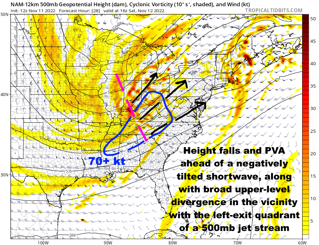
It's hard to overstate how thermodynamic the instability will be Monday and Monday night...you've got this pristine EML advecting in: This impressively rich low-level moisture will be advecting into the Ohio Valley, southern Great Lakes, and Upper Mississippi Valley beneath the advecting EML: Despite the outstanding thermodynamics, the synoptic forcing is fairly modest (some right-entrance support over the Great Lakes) and at the base of the EML will be very warm 700-850mb temperatures acting as a cap: The cap will be breakable in a narrow zone along and just north of the warm front...but with weak synoptic forcing, more robust convective development and subsequent upscale growth will likely be heavily tied to MCVs leftover from tonight's convection moving out of the Plains. A strong MCV will likely spark a robust subsequent MCS from the Upper Mississippi Valley into parts of the southern Great Lakes, mid or upper Ohio Valley, central Appalachians and perhaps eventually the Mid Atlantic. Given the thermodynamics and shear in place, the potential would exist for such an MCS to produce enough wind damage to be considered a derecho. However, CAMs so far struggling to agree on a solution. This is likely due to how sensitive the set-up is to tonight's upstream convection and MCVs it leaves into tomorrow (along with perhaps some modest strengthening of the upper level jet streak glancing the region), along with multiple forcing mechanisms and a rich environment to work with. There may be multiple MCVs, and some modest lift feeding into the right-entrance quadrant glancing the region may also aid some in allowing for convection that initiates to grow upscale: Can note the multiple subtle vorts/perturbations drifting out of the Plains into the Upper Midwest and Great Lakes as a result from tonight's convection in the Plains...these will likely be very tied to where new activity initiates on Monday. Can also note the right-entrance quadrant of a jet streak glancing the region, along with some hints that whatever upper level outflow occurs from convection over the Upper Midwest or Great Lakes may positively feedback with that for a time. If multiple rounds initiate at about the same time Monday afternoon or evening, there could be enough competition to lower the potential for any one cluster to turn into a particularly long-lasting and potent wind producer. Overall, my gut feeling is that at least one cluster will be dominant enough for a time to produce a pretty good swath of wind damage, but this could happen anywhere from the Upper Mississippi Valley to the lower Great Lakes, mid and upper Ohio Valley, central Appalachians or even Mid Atlantic between Monday afternoon and Tuesday morning. Potential exists for a higher-end event to be sure, but several ways it's at least somewhat limited. The MCV running east/southeast quickly may cause initiation earlier than optimal towards the Ohio Valley, slowing moisture/instability return farther north and also not taking full advantage of the environment coming together. Multiple areas of initiation at the same time could limit longevity of anything really potent, as there'd be too much competition eventually as stuff grows upscale. The greatest potential for a derecho to playout would be if initiation occurred mid-late afternoon in the Upper Mississippi Valley with one relatively dominant cluster and little out ahead of it, with the activity spreading through the southern Great Lakes into the evening and into the mid-upper Ohio Valley late evening or towards the overnight. Given rich theta-e air feeding in from the southwest through Monday night, if we do see one or more MCSs producing robust cold pools, back-building and flash flooding may locally become a problem as the moist and unstable air would get lofted over the shallow cold pools by the low-level jet overnight, possibly causing back-building. Any initial cellular convection would have a large to perhaps very large hail risk given the robust EML and huge instability...some tornado risk too, both with any initial supercells and with any more robust bowing segments that may play out as stuff grows upscale.


- 850 replies
-
- 14
-
-
-
Ended up measuring slightly under 3" when I walked out the door at 7 AM...the burst that moved through after I left likely pushed the total a bit over 3". It was an interesting drive west along 480 to Brooklyn Heights, alternating between heavy snow and graupel, with the roads covered in many areas. They were out plowing. Some of it survived the afternoon on the ground.
-
Didn't really stick at home yesterday, but did immediately to my north/west and had about 1" at the office in Brooklyn Heights. Drove out to Ottawa County in the evening and there was 1-3" the entire way through Sandusky, before dropping off to the west. Most was in parts of Lorain and Erie Counties. Just woke up to about 2" of lake effect this morning, which was a surprise...covering everything, including a lesser amount on pavement. Very scenic.
-
Had a little over an inch here this morning when I left. Was coming down hard enough to make the roads a bit slushy along 480 and 422 in eastern Cuyahoga County around 6:30. And as is typical this late, not a trace left by midafternoon. A bit of a surprise, surface temps dropped to 32-33 pretty quickly as steady precip came in and allowed much of it to fall as snow.
-
A little over 1.5” here yesterday (about 0.5” in the morning that melted, then a little over an inch in the afternoon that started melting). 3.5” last night into this morning. So at roughly 5” for the event, but roughly 3 on the ground.
-
Ground is covered here as well, though just a few tenths so far. It’s looking like a nice burst will drop in from the NW later this morning and will give it a go to accumulate during the daylight hours at the end of March. Trend has been for temperatures to drop a bit quicker into tonight allowing good lake/upslope enhanced snow to kick in this evening into Sunday morning for a good 12 or so hour period (a bit longer in NW PA and SW NY where the deeper synoptic moisture pulls away slower) before activity tapers to lingering multi-banded LES that may linger through early Monday, especially downwind of Lake Huron into PA. The temperature profile will favor very efficient snowfall by later tonight with 850mb temps dropping to -15 to -18C, near climo mins for this late in the season, with some lingering moisture below 800mb allowing for some fluffy accumulations to continue under any organized bands through Sunday night. Given a better shot at some accumulation today and a pretty good window tonight into Sunday morning, feel the higher terrain will do quite well. Think the current headlines that were thankfully issued just before the 11th hour are fine, though northern Geauga will get awfully close to needing a warning and given how well these areas do in a lake enhanced/upslope situation with a WNW flow such as tonight, northern Medina, Summit, and Portage may get a few inches too and push advisory criteria amounts.


.gif.2ecc34a5bdba2895d5cd3c6838039651.gif)
.gif.50593ef89d8427cc605ec3bdbba97f08.gif)