

frd
-
Posts
5,705 -
Joined
-
Last visited
Content Type
Profiles
Blogs
Forums
American Weather
Media Demo
Store
Gallery
Posts posted by frd
-
-
Just now, psuhoffman said:
if you’re Webb
At least he is bullish on Feb, as you are, and believes we have very significant - NAO later in Jan and Feb.
-
 1
1
-
-
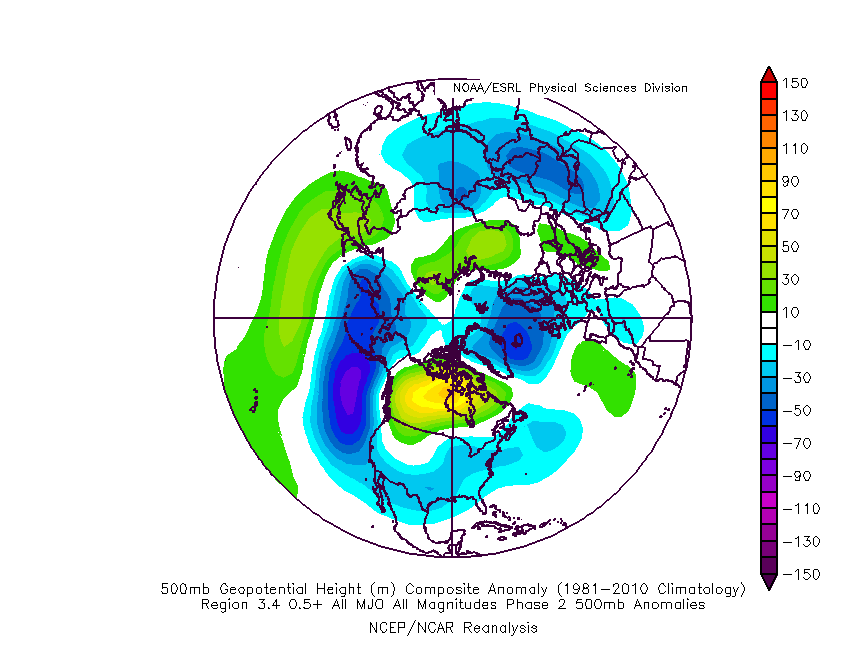
22 minutes ago, CAPE said:
Looks toasty, quite perturbed and stretched. As advertised this configuration would seem to favor development of a more sustained -NAO mid month and beyond
-
16 minutes ago, CAPE said:
The advertised h5 pattern for around the 5th in particular looks quite favorable for a MA winter storm.
The weekend rule. Sure looks nice.
-
1
-
-
SSWE in Jan. has historical analogs as support.
-
Stongest signal yet for a major SSWE. We all know we do not require one to have meaningful snow events, however, concerns of a very cold and very strong PV are much diminshed currently.
What this may help is, raising the odds of significant winter weather in ealy to mid Feb matching up with previous MECS.
-
1
-
-
7 minutes ago, Chris78 said:
Bam cherry picked that map. The GEFS is colder overall at 850s through the end of the run. Click through on TT and you'll see.
They have gone cold and snowy in the East the last three years and have done poorly. This year the forecast from BAMM WX is a warmer than usual winter, and below normal snowfall.
They believed in the extreme - EPO forecasts from a couple years back and that did not work out. Have to see how the season ends and whether they will be correct.
-
 1
1
-
-
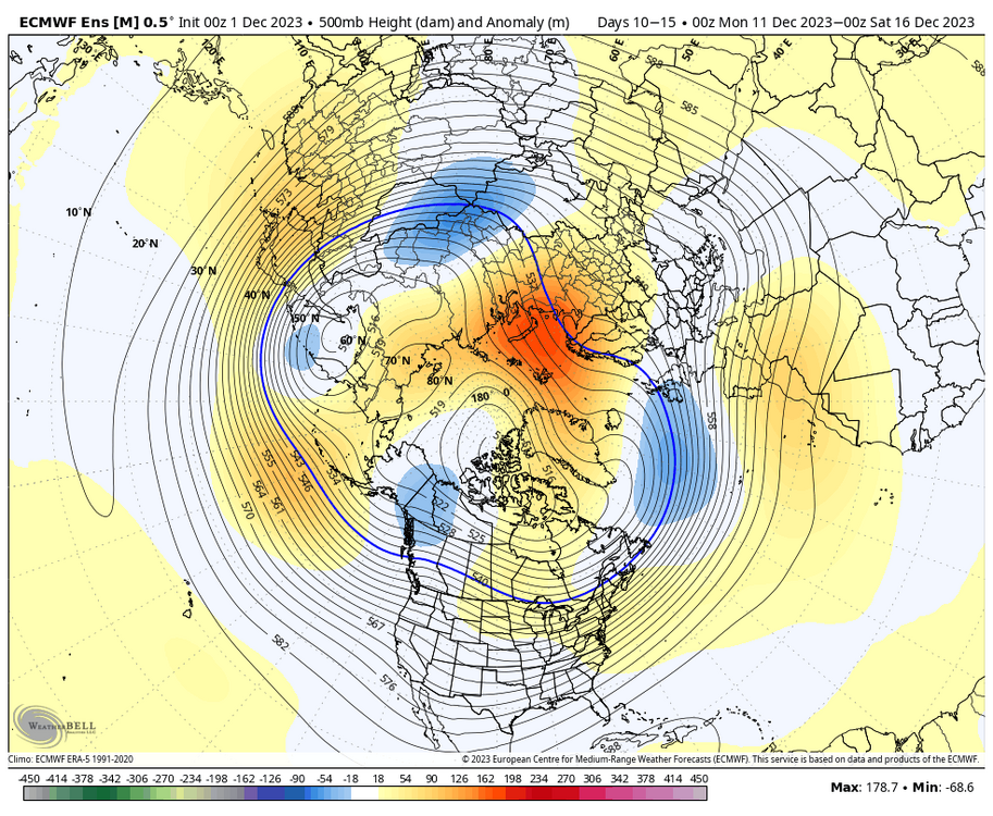
8 minutes ago, CAPE said:
This is the surface that goes with the h5 panel I posted above. That's a hell of nice a look up top with a strong wave tracking eastward.

Ah, its the @40/70 Benchmark Mid Atlantic storm set-up. Two bad its two weeks out, however, moving in the right direction for sure.
We shall be tracking in early 2024

-
2
-
-
2 minutes ago, Ji said:
details? I thought the weeklies occured on Mon and Thursday
I think they run daily now.
-
2
-
-
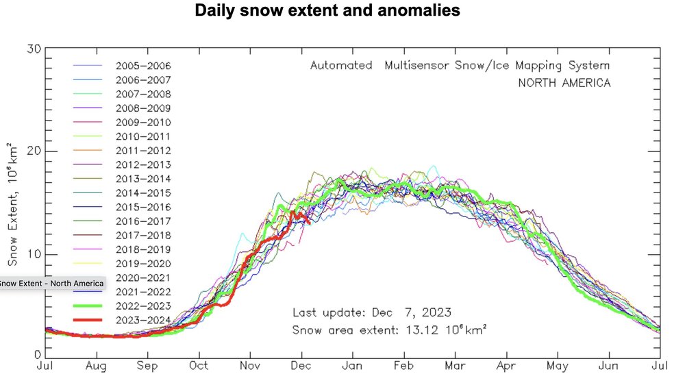
16 minutes ago, bluewave said:
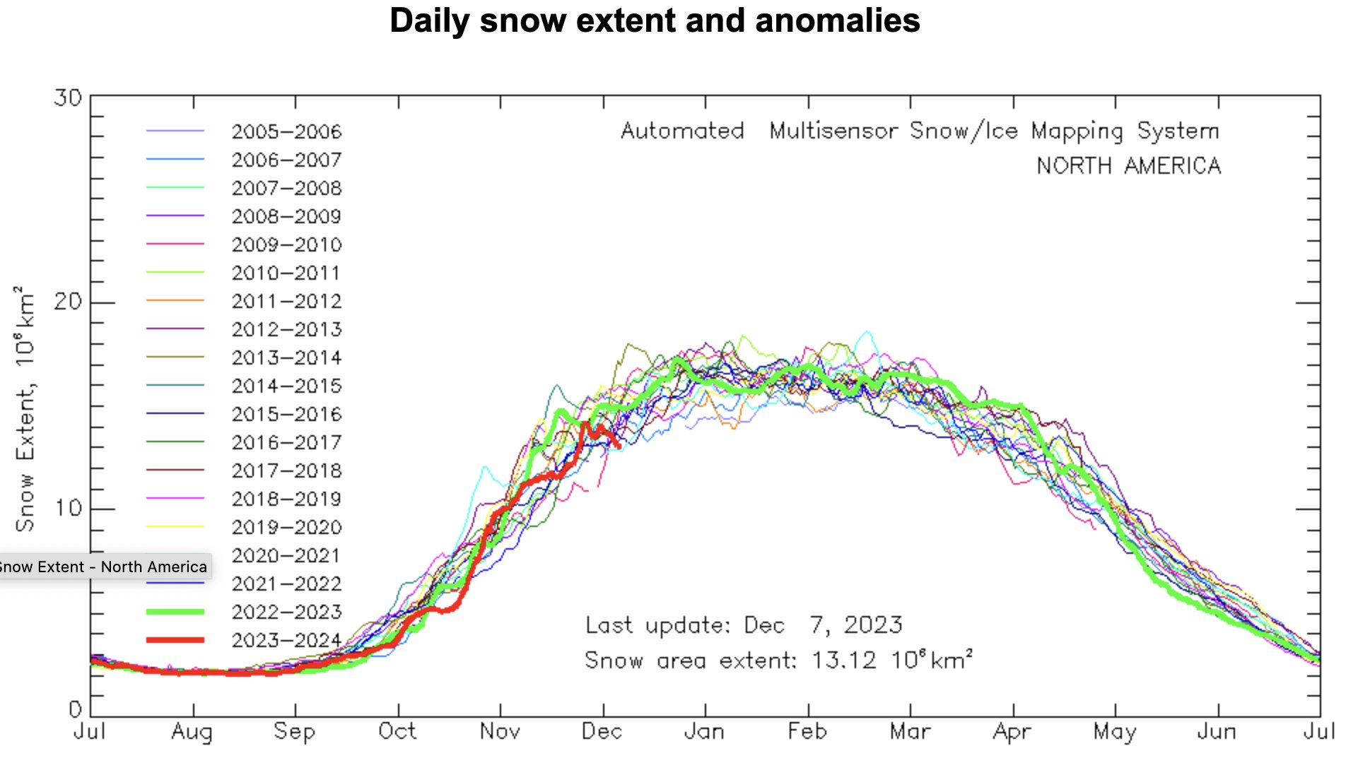
Whenever Canada gets this warm, the North American snow cover extent goes way down.
https://globalcryospherewatch.org/state_of_cryo/snow/
This might effect how fast temps get back to normal and dare I say below normal up North after Jan 1 st. The cryosphere is looking sick. Decadal low snow extent.
-
57 minutes ago, bluewave said:
Same for me. I originally had +2.5 to +5.0 range for the various NYC metro stations. I use a 2.5° scale. -2.5 to -5.0…0 to -2.5…0 to +2.5…+2.5 to 5.0. On my map the +2.5 line is just to our south this month. And the +5.0 is to our NW closer to the Great Lakes. There may also be a 10+ departure region this month in the Upper Midwest near International Falls.
Currently +4.5 for EWR….NYC….+4.6…ISP….+4.1.
Read Canada will have + 20 departures, thats insane and sad.
-
2
-
-
1 hour ago, psuhoffman said:
Just to clarify
1) all the week3+ extended guidance still looks great.
2) I still expect it to eventually be correct. I think it was just too fast getting there initially and felt that might be true even a week ago.
3)but I am acknowledging that for about 7 days now the better looks are stuck at day 16-20 just outside the actual ensemble range mostly. At times it’s snuck into day 15 for a run then retreated. And that’s frustrating. Just noting that observation.Some are mentioning the Jet Extension will cause the - PDO to become more positive during the next three weeks. Are you considering this possible outcome?
-
1 hour ago, psuhoffman said:
So do we want a ridge there or a trough. We’ve failed both ways lately. If we fail again the problem is way bigger than any one specific artifact of the long wave pattern.
Whatever gets us snow . But seriously, maybe the transition starts in early to mid January and then improves from there similar to 1965-66.
Looking for improvements in the Pac, but also the HL and the NAO region by mid Jan. As you said, if we do not start to see things improve in the long range guideance by the first of the year then we can really start to worry, however currently I remain hopeful.
-
3 minutes ago, Ji said:
The weeklies had been rock solid for months till it came time to turn cold and snowyAnother modeling failure. Persistence greater than modeling.
Looks like well into Jan. regarding any chance at all for meaningful snowfall. Extreme Pacific Trough regime well in Jan.
-
2
-
1
-
-
36 minutes ago, Weather Will said:
One of the reasons the colder look has disappeared as we head into January is the MJO is now forecast to go into the null phase rather than do the loop through 7. Hopefully that will be wrong.


ensemble mean PT index at 1.5 sigma at a 2 week lead is wild according to Dr Simmon Lee. Last December we were in a robust Greenland High regime from December 2 to December 19th then we flipped to a Pacific trough regime for the last week of December.
The PT regime is associated with atmospheric rivers into the West Coast and very warm temperatures across the continent.
Going to take time to recover from this. Nino Decembers are warm and in general recent Decembers have trended warmer. But the current PT regime is rather remarkable.
-
The last three Decembers, at this time of the month, North America snowfall was robust. Then as late December arrived North America snowfall coverage declined rapidly. The pattern after that drop off was not conducive for sustained cold or snowfall.
What is interesting now is that snowfall extent in North America is at decadal lows. Say what you want about about El Ninos, that they tend to produce above average snowfall in our region. As for tempertures, air masses are not frigid, just cold enough to snow.
I am interested in seeing how NA snow cover trends in the weeks ahead. Certainly I would imagine to get seasoanl temps here, we would like to see a better cryosphere in our source regions to deliver cold air. Looks like it is going to take a while.
-
2
-
-
2 hours ago, thunderbolt said:
That also goes for number two
MJO phase significance changes based on the three month period you are in.
-
Interesting post by @bluewave
One of the main issues with the longer range model forecasts for the MJO beyond 10 days is that the ensembles weaken the convective signal too much. This is also true with the RMM charts. So some of the posts on twitter stating that the MJO will quickly weaken or progress to 8-1-2 are basing that on an an inherent model bias. So it’s no surprise that the convection in the warm phases this week is verifying more intense in the warm phases than the runs back in late November were indicating. This is one of the reasons ensemble forecasts have been correcting warmer for December than they were indicating later in November. So even if the MJO can eventually get over into phase 8-1-2, that is also a warmer signal from December into January with an El Niño.
New run

Old run

-
1
-
 1
1
-
 1
1
-
-
Interesting MJO read from Don S:
<The latest MJO forecasts show a slightly longer passage through Phases 4-6 than had been shown two days earlier (Bluewave has discussed the role of sea surface temperature anomalies in foreshadowing such an outcome):
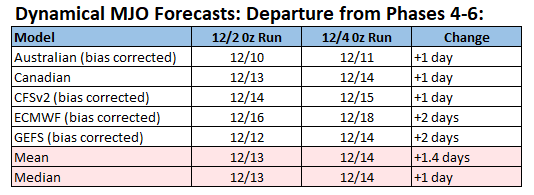
The Week 3 CFSv2 (12/18-24) and ECMWF (12/18-25) are very warm in the East (>3°C/5.4°F above normal). Were blocking to break down, the possibility of one or more days in the 60s in the region (maybe even 70° in the Baltimore-Washington area) during that timeframe would increase markedly. Beyond Week 3, the ECMWF weeklies still show cooler than normal readings in the East to start January. However, skill levels beyond two weeks are low.
The latest ENSO data shows that a basinwide strong El Niño event continues. The latest ENSO Region 1+2 anomaly was +2.1°C. The latest ENSO Region 3.4 anomaly was +2.0°C. The AAM is poised to go positive in coming days and then strongly positive through at least late December. A positive AAM often indicates patterns consistent with El Niño events. El Niño cases favor warm Decembers in the East, though there are exceptions.
With winter largely sleeping through the medium-term, New York City's and Philadelphia's record streaks without their having seen 1" or more daily snowfall will continue for the foreseeable future. New York City's ongoing streak will very likely surpass the existing record streaks at Newark (661 days) and Trenton (664 days).>
-
12 minutes ago, Kevin Reilly said:
Our new normal.
Like clockwork.
However, I believe phase 7 is the warmest MJO phase. Just need to move forward, which appears we will.
Even though the modeling has trended warmer sensing the changes in the Pac, along with a more negative PNA versus neutral, is that the AO continues to be forecasted very negative, and remaining so for the medium term, rather unusual, but bodes well for us very late month and in Jan. and Feb.
-
1
-
-
7 minutes ago, GaWx said:
Per this GEFS prog mean, the 12/1-16 AO may end up the 2nd lowest to 2022 back to 1950. The only others that were sub -2 were 2009 and 1985. So, only 3 sub -2 back to 1950 with 2023 progged by GEFS to become only the 4th:

Last year we had an extreme - AO and a extreme - NAO that resulted in no snow for my region. The
Pac is king in my opinion Even Don S thought we would be getting a huge snow event along with Bluewave, and nothing ever happened of consequence.The extreme - AO is normally a great indocator of snow potential, but recently that indice has not held to its historical importance and value when predicting a window for a SECS.
-
2
-
-
17 minutes ago, Weather Will said:
The weekly control, yes I know just one member, is a torch Christmas week. That is a warning shot....
The usual warmth starting around the December 18 th to 20 th has been a fixture in the East the last several years. When you look at Atlantic ocean temps and the very warm Fall we have had it is easy to see that September is a summer month and Decembers are generally more fallish lately than wintery. On the flip side, March will be the wild card. Looking at the latest data regarding the MJO and its progression and Nino SSTs it appears December overall should start to be modeled warmer and the holiday period that had some potential may not work out that way. Sounds like a typical Nino.
-
1
-
-
1 hour ago, brooklynwx99 said:
i do like the B-K Sea / Scandi ridging showing up on all ENS. that helps weaken the SPV as well as perhaps retrograde into the NAO domain
May trigger a SSWE
Not that we need it, but it is interesting.
Latest AO observation forecast looks favorable for an early season weak polar vortex.
-
43 minutes ago, Weather Will said:
MJO gets toward 7 by the 14th... hopefully laying the foundation for a more favorable pattern as we head toward the holidays.


Amplitude might be trender higher in recent MJO forecasts. Late month continues to look interesting.
-
Still thinking late month has potential.
-
5
-


Dec/Jan Medium/Long Range Disco
in Mid Atlantic
Posted