

frd
-
Posts
5,705 -
Joined
-
Last visited
Content Type
Profiles
Blogs
Forums
American Weather
Media Demo
Store
Gallery
Posts posted by frd
-
-
2 minutes ago, Eskimo Joe said:
Pacific Puke every year.
Pac jet intensifies near Japan and causes the previously modeled Western ridge to go poof. Again the very fast Pac flow overpowers. This goes back to conversations from 2018-19 regarding the Western Pac super warm pool , causing increased warmer MJO phases, which possibly last longer. Plenty of times the last several winters where the fast Pac flow erroded Western ridge/ + PNAs, and also flooded Canada with Pac puke airmasses. Hopefully as we go deeper into the winter season this concern may reduce, allowing a more typical Nino Jan. and Feb to take hold.
-
 2
2
-
-
3 minutes ago, DarkSharkWX said:
nice -NAO/+PNA showing up here
snowfall at DCA in these months:Dec 1981: 1.7"
Dec 1952: 2.0"
Dec 2009: 16.6"
Dec 1955: 0.5"
Dec 1961: 1.2"
Dec 1996: 0.2"
Dec 1987: T
Nov 1981:T
Dec 2000: 2.0"More realistic potential versus the never correct Euro Control run.
-
1
-
-
54 minutes ago, psuhoffman said:
Wow, an area along and West of the lower Eastern Shore with 70 % probability of above normal snowfall. Our area firmly in the 40 % probability of above normal snowfall. Looks hopeful.
-
5 minutes ago, CAPE said:
Bowling ball straight across taking the southern route, with no destructive interference from the NS. Nino baby.
SECSyyyyy Me like !!!
-
.png.a11d2bcd443fa239032749e36553f686.png)
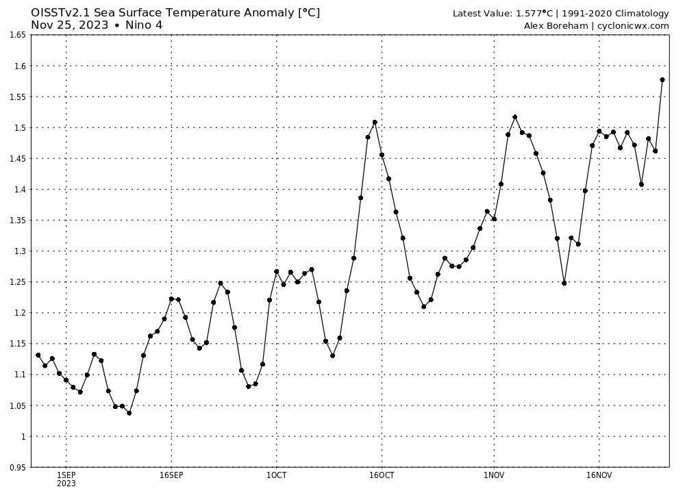
SSTs of Nino region 4 have really increased recently. This Nino is still ramping up.
-
1
-
-
4 minutes ago, CAPE said:
Latest GEFS MJO forecast takes convection the into phase 3 then kills it. Previously it was progressing into phase 4 with decreasing amplitude. This is what we would expect to see in a Nino.. the antithesis of a Nina.
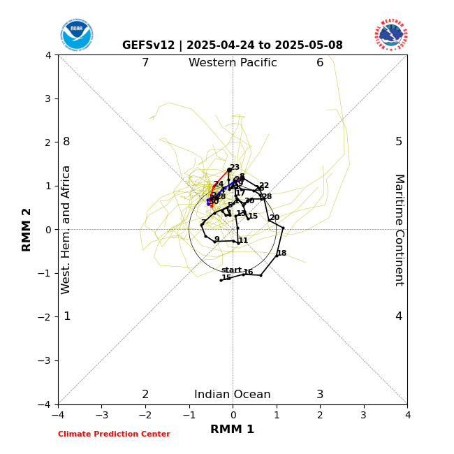
May emerge in phase 8 at a low amplitude prior to the holidays, meanwhile the AO looks awesome as we head into December.
.thumb.png.a385957f5440e72debd984da1f235889.png)
-
7
-
-
20 minutes ago, Eskimo Joe said:
That's a KU look.
And so it begins

-
3 minutes ago, Eskimo Joe said:
The trends with the AO have been remarkable in regards to forecasts of such a deep dive into the negative. -3.0 deviation forecast for early December and no real rebound afterwards of significance. Just need moisture and maybe we score after the 7th.
-
1
-
-
51 minutes ago, 40/70 Benchmark said:
January 2003 looks like it had the dual forcing that Chris pointed out.

If using similiar rollovers would that not lead to/and or support a higher probability of MECS later in Jan and early Feb ?
I am liking the overall trends here with the Pac and the HL. Hopefully, no fakeouts this winter season.
-
1
-
-
Just now, 40/70 Benchmark said:
I could see a thaw in early January before we go more favorable again later in the month.
Do you believe the pattern evolving with an improved Pac leads to a cold stormy outlook for the East in mid December, leading up to and including the holidays?
-
27 minutes ago, Weather Will said:
WB 12Z GFS, my non expert eye says at 12 days out this the is one to watch...

Better odds than last December when the
block was further South and the West Coast set up was slightly different. AO progged to be diving just prior to this time.
-
4
-
-
12 hours ago, Allsnow said:
If we don’t have a good pacific it’s worthless
Last December also had a great Greenland block. Maybe just bad luck. But to me the Pac rules.
-
1 hour ago, CAPE said:
The guidance continues to hint at a wave or waves ejecting eastward from the southwest for the end of the month. As I mentioned a couple of days ago, the biggest issue(other than climo) is associated with energy dropping southeastward in the flow between the western ridge and the southward displaced TPV. Busy northern stream. Ideally a wave taking the southern route would be timed such that it can remain intact as it progresses eastward without being directly underneath or in the immediate wake of NS vorticity. Some sort of a phase is another possibility. Guidance struggles with these types of patterns at range so we keep monitoring.
Looking ahead to early Dec, there are some mixed signals on the ensembles, partly associated with the MJO progression. In general it appears the primary TPV will retreat well to the northwest and a ridge will build into central Canada, while we lose the Aleutian low/ -EPO. The NS would become more 'quiet' in this scenario, but the central and eastern US would become milder. There may be a brief window the first few days Dec for a wave to track underneath as the pattern transitions with some cold still around. Goes without saying that the risk for frozen in the lowlands is pretty low for this entire period. If the current MJO continues to progress/weaken, we should see a return to a colder pattern mid December.
Can you imagine the excitement if we transition to colder will possible snow towards the end of December to coincide with the winter solstice I have been waiting for that for many many years.
-
3
-
 2
2
-
-
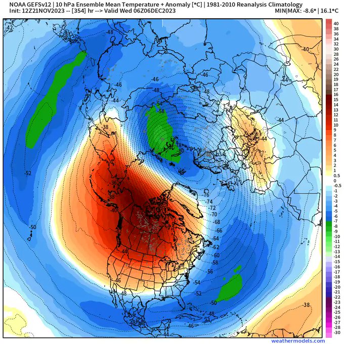
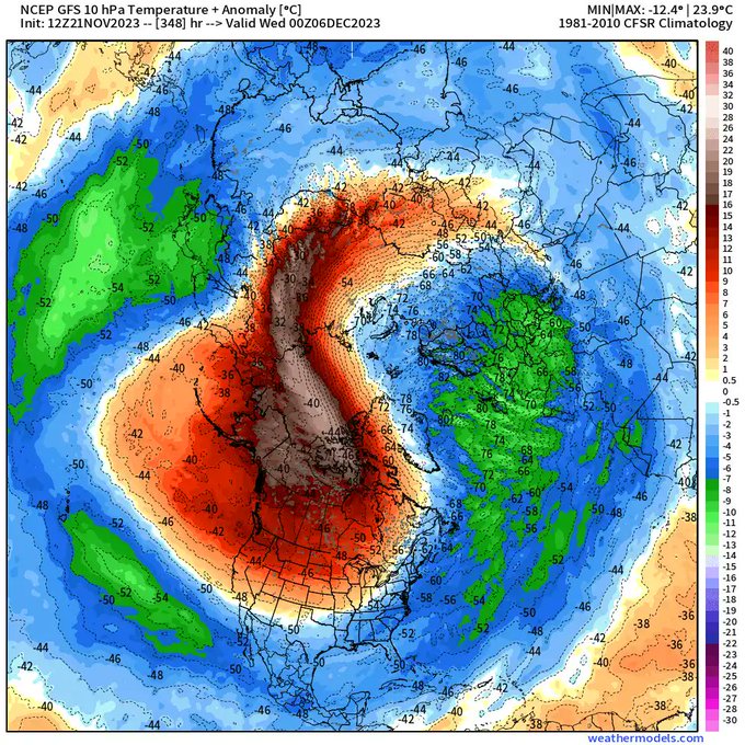
1 hour ago, brooklynwx99 said:
ECMWF extended really dropped the strength of the SPV compared to yesterday... ends up weaker than average for most of December now

Resulting in this from the GFS / GEFS for early December. Hoping for a favorable look up top as we near later December, or even sooner, to better coincide with mid to late December snowfall climo.
-
7
-
-
4 minutes ago, Ji said:

Looks like cross polar flow there.
Nice Pac. No signs of a - NAO yet. But, the Pac will trump the Atlantic.
-
3
-
-
On 11/3/2023 at 9:19 AM, Allsnow said:
This is just a small piece of the puzzle and can recover quickly but hopefully this means something better in December
Currently going in the opposite direction. And even with a deep AO the cold in recent years all dumped out West and even into Texas.
.thumb.png.81332ab5a377516c9404c12c653bc06e.png)
-
1
-
-
5 hours ago, Weather Will said:
WB latest GEFS extended and EPS weeklies do forecast snow in our cold source regions the next month, which can't hurt our prospects for some cold in December.
4 out of the last 6 years there has been record North America snow cover in December, with several of those winters showing indications of a weaker PV demonstrated by significant periods of a negative AO. A few Decembers during this period had a cold weather in the East. However, the majority lost the record snow cover and it turned warmer after mid to late December. Not sure if any one signal, or long range model has any accuracy in this day and age. Even the periods with a deeply negative AO , a great indicator of snow potential , produced very little, if any snowfall here. Seems possible that a perfect Pacific pattern may be needed to produce snowfall in the Mid Atlantic region.
-
BWI: Nov 12
IAD: Nov 11
DCA: Nov 13
RIC: Nov 13
BWI Departure: +1.1
-
3 hours ago, WxUSAF said:
South polar winter vortex was at or near record strength last year with very high water vapor levels.
If the same outcome would happen in the NH looking for the first signs by early December. This is one way to ruin a possible decent setup with a Negative and descending QBO and West based forcing.
-
3 hours ago, Eskimo Joe said:
My wife is going bonkers with no sun since last Saturday. Really hope we can manage a few hours of sun today.
I feel depressed, must be seasonal sun disorder, lots of people have it. Coffee is awesome, but some sun and D3 would do wonders.
-
1
-
-
13 minutes ago, CAPE said:
It has had the favorable Nino h5 look for multiple runs, with the last 2 being especially weenie. Would be a bad sign if it bailed now when we are actually sniffing winter.
I believe the seasonal modelas have the best look since 15-16, however, wondering if the polar state changes late Fall despite the early favorablre look up top due to the increased water vapor injecting at the high lattitudes causing a possible colder general look up top with less blocking. Otherwise, hopeful at this time.
-
1
-
-
5 hours ago, Eskimo Joe said:
I am very hopeful regarding a - QBO, but worried about the water vapor release from the erruption of Honga Tonga messing things up and cooling the PV starting in late Fall. .
5 hours ago, Eskimo Joe said: -
Pretty cool radar loop showing intensification right up until the point of landfall.
-
5
-
1
-
-
4 minutes ago, WxWatcher007 said:
Gusts to 58 & 64 mph at Lewes, DE.
to add to that
-
4
-
1
-
.png.017194b491e48b7af3e90e3a477e1ae7.png)

.png.c3d9c456c3a3fbf0a5b810752395a3da.png)
December Mid/Long Range Discussion
in Mid Atlantic
Posted
Cold initially favoring Asia and Europe, then as the MJO progresses, along with favorable changes in Pac., arctic airhopefully makes it way towards us near the holidays, along with increased odds of storminess.
Expansive cold centered near December 9 th over Europe and Asia.