

frd
-
Posts
5,700 -
Joined
-
Last visited
Content Type
Profiles
Blogs
Forums
American Weather
Media Demo
Store
Gallery
Posts posted by frd
-
-
2 minutes ago, brooklynwx99 said:
it hasn't slowed. it's been in nearly the same spot for two weeks
Thanks, I must be impatient.
-
 3
3
-
-
1 hour ago, Weather Will said:
I was disappointed in the entire EPS run but will wait for the experts. Seemed like a step back to me. Not much progression and trough weakening as it heads east. SER is holding tough. But it is just one run.


Appears the undercutting trough developing under the block has slowed significantly the last 48 hours. Atlantic also looks different versus a couple days ago. Maybe require a few additional days to get to a better pattern, or maybe the modeling is simply not correct. Waiting on others to chime in.
-
1
-
-
10 minutes ago, 40/70 Benchmark said:
Someone far, far south of me has a shot to pull a January 2016.
Enjoy the chase....I'm waiting for mid February, at least.
You really think that's possible?
-
DT is excited
INCREASING THREAT FOR MAJOR WINTER STORM FOR TENN VALLEY AND MID ATLANTIC FEB 4-5
-
5
-
 2
2
-
 4
4
-
-
36 minutes ago, CAPE said:
Our epic winter period is right around the corner. Just another couple weeks. Hang tight y'all.
")
Been here for many years, and I believe I never remember you being so hopeful. Let's do this !!!
-
3
-
-
Webb might be on to something.
-
1
-
-
4 minutes ago, Scarlet Pimpernel said:
I don't typically look at or pay much attention to those snow maps, but a couple of people the other day posted the Euro extended mean and extended control, and there was a mention that those had a fair bit more snow for this area compared to awhile back. So maybe it's "moved" that way somewhat?
Thanks, I would hope, and expect as the ops get closer to the extended range modeling the snow mean, given the potential of the pattern should indeed move South and increase. I have not seen any snowfall mean maps recently. I am pumped for what the models are showing.
-
18 minutes ago, psuhoffman said:
Not me. Just about every Nino pattern match produced multiple big storms
Did you think by next week 2/3 we begin to see the modeled snow mean start to move South closer to our area, as well as increase?
Or, do you think it is still too early?
-
6 minutes ago, psuhoffman said:
There is some crazy shit starting to show up in the long range. Storms getting trapped under 40* and meandering around. Redonculous retrogrades. Fun times ahead.
Maybe once it starts snowing it will not stop.
 I am on the psu train, edit..... sled I mean
-
3 minutes ago, Ji said:
HorrificYep climo, that amount here, plus what has fallen already the last two events would give me a below average snowfall season. Go big, or go home !
Just a snow map of course, the pattern looks very promising, lets hope it delivers like a blend of 1958 and 2010.
-
1
-
-
4 minutes ago, IronTy said:
There has been a number of posts about how we're still in the game well into March in this thread. So I went and looked at historical snow totals at DCA by month. According the the data I saw, we've only gotten double-digit snow totals for the entire month of March twice in recent eras. Once I think was 2014, and before that it was either was like 1959 or 1969 or somewhere there about. So I don't get where the March optimism comes from.
Eta, went and found the data again, it was 1960.
March certainly can be a much, much colder and stormier version of December.
Shorter wavelenghts, increased odds of late season HL and NAO blocking. I experienced a few wicked March snow events here in the last 15 years.
March 2018 I believe was the retro - NAO which lead to 7 F, snowfall and blowing snow, and multiple school clsoings. And, there are other examples too. If things work out as portrayed by the weeklies a version of 2018 could happen. Will be fun to observe the pattern to see what it brings.
-
2
-
-
This looks much better recently.
.thumb.png.11b72cb9b0d2bc3a8f8205ee54ccfc72.png)
-
3
-
-
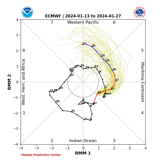
1 minute ago, brooklynwx99 said:
the EPS and other ENS are following the weeklies to a T. get the STJ in the west to connect with the N Atl trough and all of a sudden, you’re in a very good pattern
Does it still show S/Ws flying around the base way out in La La Land ?
I think once achieved this could be a rather active and cold pattern setting up. May have legs too.
-
37 minutes ago, CAPE said:
Maybe the recent cooling near the MC will encourage a shift in the convection further eastward into the Central Pac.

Rapidly weakening already set in motion.
-
6 minutes ago, Ji said:
I feel better about winter since Judah just canceled it
https://x.com/judah47/status/1749430822120133107?s=46&t=C005pd5HNg3Y-KhVU7n3VALOL. Second time I believe. Don't tell @CAPE Poor Judah, weather does not exsist in a vacum. THE PV and the HL should become more favorable again with a decent Pac and plenty of threats to track
I am very excited myself for the period Feb 10 th to March 10 th.
-
2
-
-
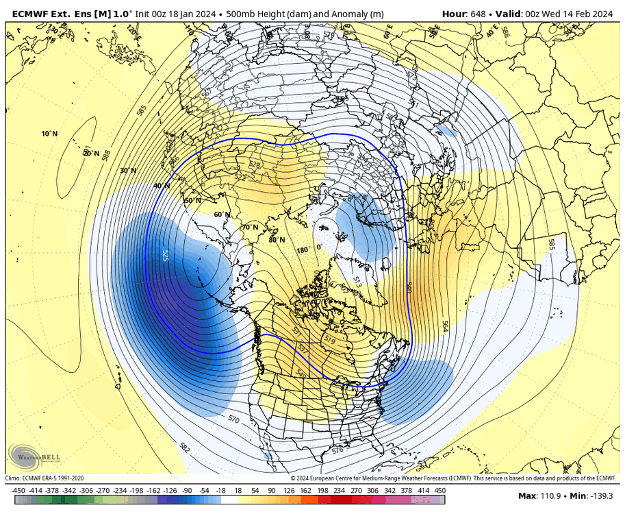
31 minutes ago, CAPE said:
Speaking of.. the latest edition is a damn near perfect h5 depiction. It has been very consistent with this look overall for the back half of winter. -NAO develops earlier but this period is where the pattern really becomes mature. Hard to see on this view but that is a west based -NAO.

Of course near President's Day. Looks great.
-
1
-
-
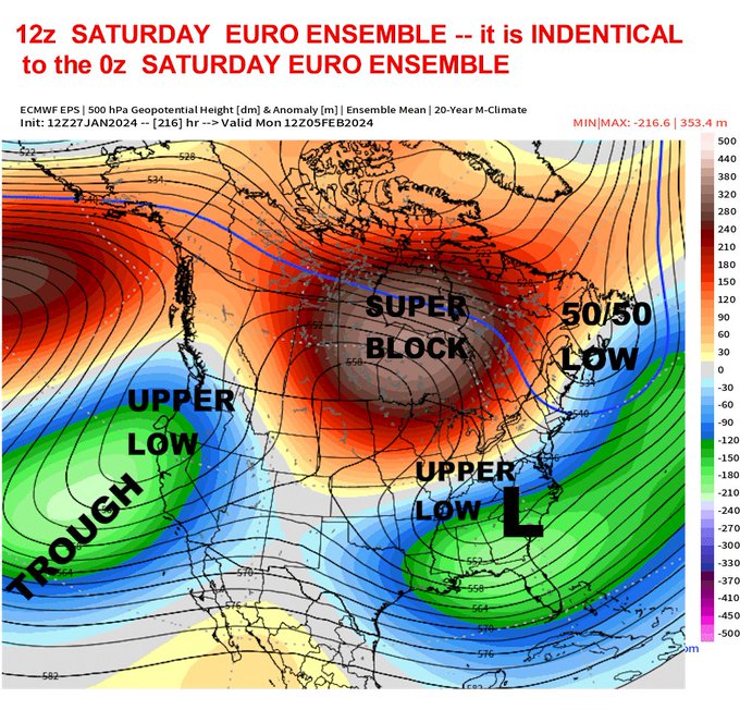
And around she goes at a higher amplitude. Moving at a decent pace as well.
-
-
4 minutes ago, SnowGoose69 said:
System is heavily NRN stream involved...GFS/CMC might school the Euro on this one til we get inside 90-100. Vice versa looks like it may happen on Tuesday, tons of SRN stream activity and GFS now looks to be the most lost of any model with that one
Great point, I have heard this before. Looking forward to monitoring this during the upcoming work week.
-
51 minutes ago, CAPE said:
STJ undercutting the western ridge. EPS depicts a pretty active southern stream with indication of h5 shortwaves in the flow.

Late month fun. We need a pattern with no path to failure. Maybe this over running pattern might be it.
-
2
-
1
-
-
1 minute ago, CAPE said:
Latest NBM

Wonder if this is the final.outcone.
Sure depressing considering some had posted this blend was doing well in forecasting.
-
27 minutes ago, CAPE said:
And this is how it can work- we get that interaction and enough dig at just the right time to induce low pressure at the coast.


Its a glancing blow though and a great outcome for north of Philly to SNE.

Too bad ridge axis is not near Boise.
Is GFS hour 384 still showing cross polar flow as psu mentioned a couple days back.?
-
1
-
-
32 minutes ago, Terpeast said:
It’s over. Will be lucky to see an inch out of this, and I’m usually one of the more optimistic ones
I hope Feb is going to be epic. We have had a severe - NAO, juiced up STJ, a severe - AO and nothing to show for it except flood issues.
One issue after another. Cruel hobby for sure.
-
 1
1
-
 1
1
-
-
21 minutes ago, Weather Will said:
WB 18Z GEFS compared to yesterday. What a cave to the EURO. They should scrap the GFS and start over....


As I said before, just because the GFS shows a snowy solution for three days in a row it really means nothing. Euro for the win yet again.
Persistence does not mean the GFS is going to be correct. This is not the first time the Euro schooled the GFS, and it will not be the last.
-
1
-
 1
1
-
1
-


.png.80d8bfa41582449de3c9f484907e1a9c.png)


Jan/Early Feb Medium/Long Range Discussion Part 3
in Mid Atlantic
Posted
My only concern is time. Simply put when the improved pattern arrives and is established let's look at the date. The later the date, the less likely to possibly achieve seasonal snowfall, or above. Caveat a MECS in which odds are higher in a Nino .