

frd
-
Posts
6,470 -
Joined
-
Last visited
Content Type
Profiles
Blogs
Forums
American Weather
Media Demo
Store
Gallery
Posts posted by frd
-
-
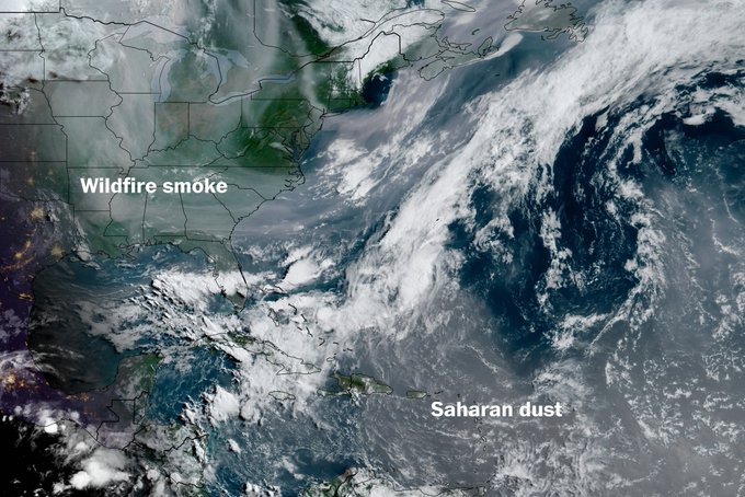
Definitely not as comfortable today with the higher temps watering the garden. As soon as I got home I could smell smoke in the air from above.
Also many insects swarming around.
-
19 minutes ago, Maestrobjwa said:
So you're telling me there's not a cloud in the sky...but all of this overcast is wildfire smoke? Wow, lol
Smoke plume thickest at this time in our area, but moving out in WV., so maybe some improvement later in the day, certainly once the winds shift to SW tomorrow. week.
close up here https://www.star.nesdis.noaa.gov/GOES/sector_band.php?sat=G19§or=ne&band=GEOCOLOR&length=24
-
 2
2
-
-
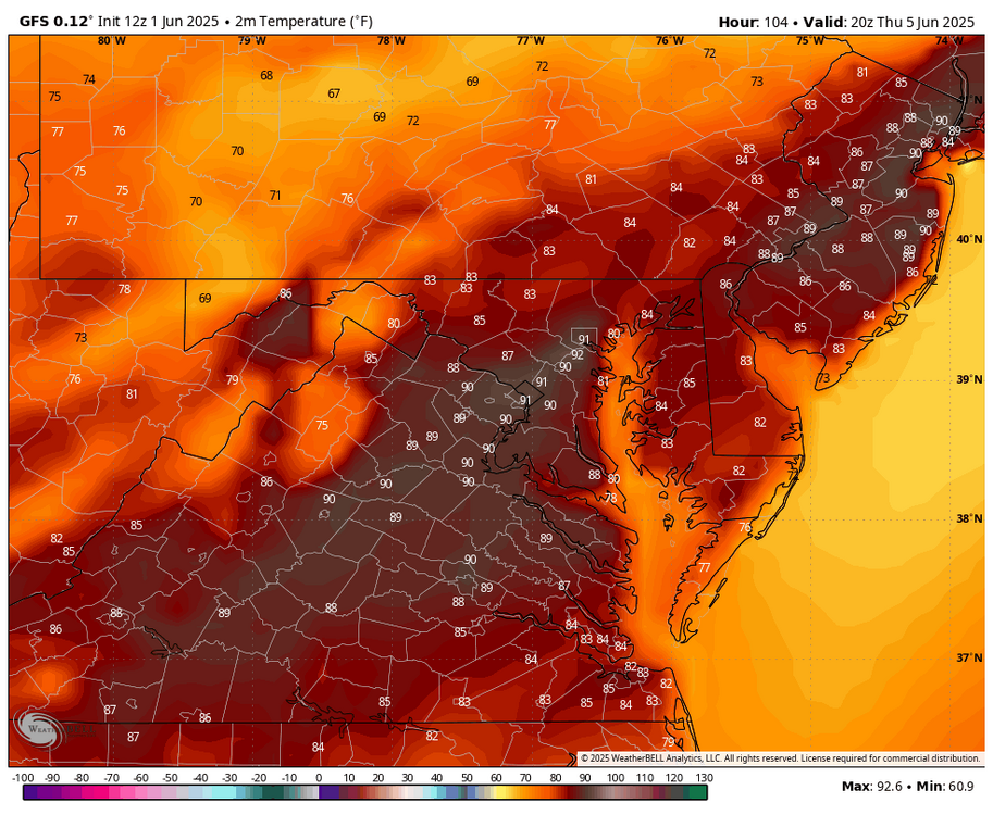
We are starting to lessen the negative temp anomalies in the East, of the note the NW US really starts to heat up, as the PNA starts to rebound. .
.thumb.png.6722cb4263f89046d3a59015f7b9aa8c.png)
-
2
-
-
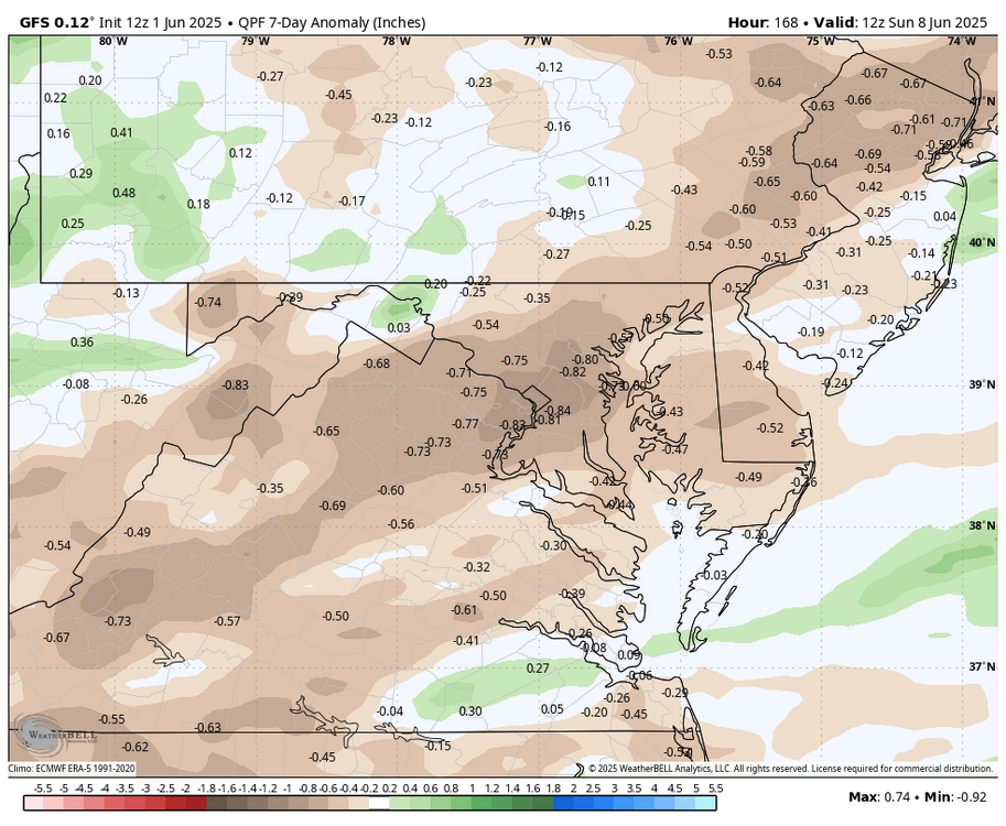
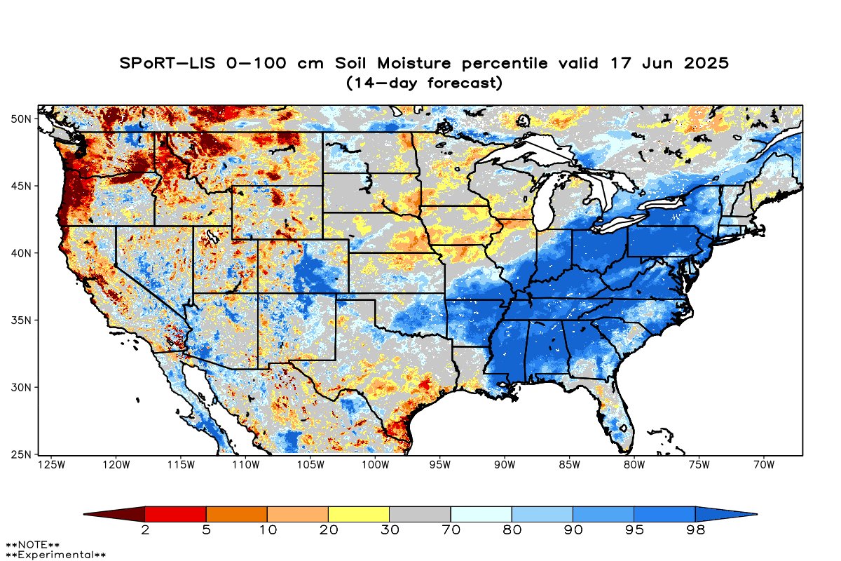
Update on soil moisture.
Much improved , seems lower DE and Western zones not as robust as the general area, but not horrible.

-
3
-
-
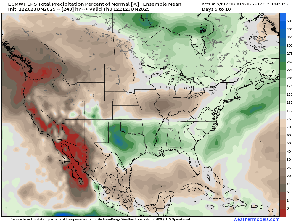
No clear signal, but some rainfall seems possible
-
55 minutes ago, dailylurker said:
I don't remember this smoke from Canada ever in my 46 years of life. Maybe the haze in the 90's was smoke? I'm definitely not saying it's some conspiracy. I'd like to know why now and never before. Or was i just not noticing it years ago?
Cloudy with thick smoke and 56
From what I have read, some of it may have to do with Forest mismanagement in Canada. I'm sure there is more to it than that. Possibly the way Canada deals with the forest fires as well. It would be something interesting to look into further.
In this morning's area forecast discussion, the Mount Holly office even states that more smoke will be evident today as it moves in from the north and west
-
2
-
-
Smoke and dust.
-
1
-
-
Low of 48, nice walking weather.
-
9 minutes ago, Weather Will said:
Sky looked like Mordor most of the day.
Saharan dust may possibly join the party by next weekend or beyond, as it travels West across the lower Atlantic and then moves NW into the Gulf and then possibly North and Northeast. Its a crazy weather world these days.
-
 1
1
-
-
7 minutes ago, Weather Will said:
Sky looked like Mordor most of the day.
It has gotten more so as the day progressed. I like the comparison.
-
15 minutes ago, nw baltimore wx said:
Definitely can smell smoke this afternoon.
Weatherwise - a bit surreal out there.
-
2
-
-
2 hours ago, Weather Will said:
First work week of June looks dry for a change....near 90 Wed. And Th. (WB 12Z GFS)
The temps here should cool a bit from the upper 80's mid to late week. Increasing probabilities of rainfall is introduced yet again on the coming weekend, however, nothing extreme at this point.
WPS seems to agree.
.gif.c4c2c5d2b7d0608f2fe823233b300af6.gif)
-
32 minutes ago, 87storms said:
I don't know if it's my allergies acting up or phantosmia playing tricks on me, but a couple times today I could smell a faint "smoky" scent, similar (but to a lesser extent) to what we experienced 2 years ago.
I imagine its possilbe if the smoke was able to mix downward. It appears the smoke issue is in the forecast for this Tuesday as well from Accuweather for our area.
.
-
2 hours ago, nw baltimore wx said:
Looks smoky out there now but maybe just high clouds.
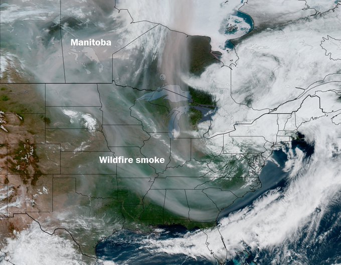
This is from yesterday, but today it is still similiar. Goes from Manitoba to almost Northern FLA.
-
Surf zone water temp for the first of June off north Wildwood,NJ.
Temperature
62°F surf
 67ºF air
3/2mm wetsuit
-
6 minutes ago, mappy said:
I need my pool to warm up so I can enjoy my version of the beach
With more sun and warmer temps I bet it improves greatly this week. I hope you enjoy your "pool beach" real soon !
-
1
-
 1
1
-
-
3 minutes ago, mappy said:
Can’t wait
Tomatoes will be happy, and maybe the ocean surf zone temps will finally respond from being stuck between 57 and 61 F. for the last two months. I am ready for the beach !
-
1 hour ago, 87storms said:
Yea, this weather ain’t it. And it appears we’re going to be contending with Canadian wildfire smoke…at least at the upper levels.
This loop sure looks like smoke in the upper levels over a wide area of the East.
https://www.star.nesdis.noaa.gov/GOES/conus_band.php?sat=G19&band=GEOCOLOR&length=24
-
1 minute ago, mappy said:
Happy Summer!!
")
Going to feel like it in a few days too !
-
1
-
-
Crazy wind gusts last few hours. The continuation of high winds is insane last few months
-
2
-
-
Storms beginning to fire up near Hagerstown and North of State College. All moving SE .
-
13 minutes ago, wxdude64 said:
That tight little vortex spinning southward in SD is interesting
Sure is. What a captivating image of the present storm system departing and the Manitoba smoke all interacting.
-
1
-
-
Half of the US seems to have Manitoba wild fire smoke, incredible !
https://www.star.nesdis.noaa.gov/GOES/conus_band.php?sat=G19&band=GEOCOLOR&length=24
-
1
-
-
1.62 " last 24 hours.
.png.cd6e05ce692ef19c78c84a8218866c69.png)

June Discobs 2025
in Mid Atlantic
Posted
Modeling suggest the worse of the heat out West this year. NW may fry. Also, there is a signal for normal, to at times above normal precip, in our area through the summer.