

frd
-
Posts
5,700 -
Joined
-
Last visited
Content Type
Profiles
Blogs
Forums
American Weather
Media Demo
Store
Gallery
Posts posted by frd
-
-
Just now, CAPE said:
The Canadian has been more bullish on the idea of a strong west based -NAO. Maybe the better models will get there.
The CMC is always more bullish on HL blocking in general it seems. In both domains.
-
1 hour ago, 40/70 Benchmark said:
No argument from me on that.....Maybe it runs a few days into March, but I think that will be a relatively nice month in terms of sensible weather. Maybe Raindance is right and there is a cold snap or two, but I am talking in the mean. I don't see a very wintry month.
So you are thinking the pattern change lasts about two weeks and then thats it? So you are going to route of the Pac not cooperating and breaking down the pattern that sets up in mid-Feb by early March?
Some are going with a cold and possibly snowy March. I have my bar set low, despite the weeklies, and ensembles. Been fooled too many times in the past.
-
3 hours ago, 40/70 Benchmark said:
12z locks the cold on the other side of the globe again.
Do you believe it though ? Thought we are headed for a - EPO + PNA pattern in mid Feb.
-
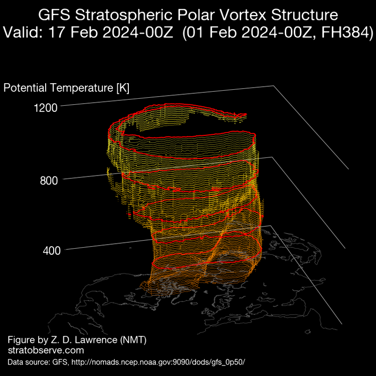
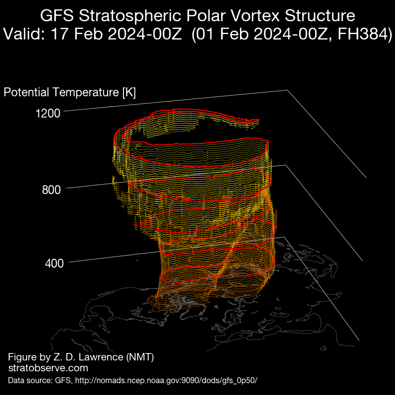
3 D Vortex
current
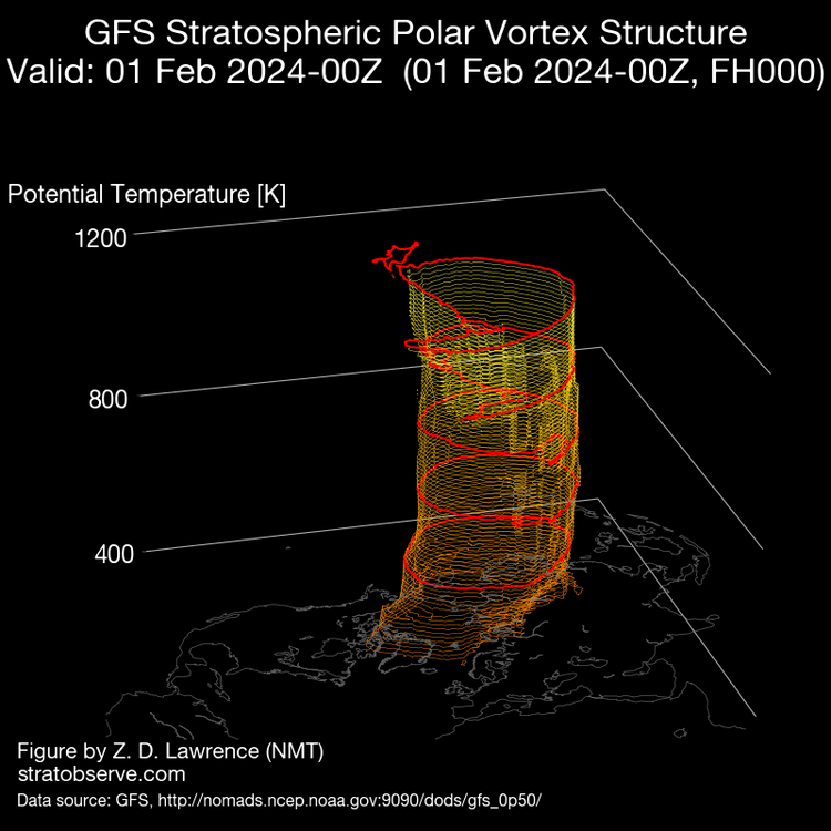
Hour 384 forecast from the GFS. Notice the bagginess and displacement North South orientation, along with hints of a split at lower levels.
Overall positive signs for the HL.
-
 2
2
-
 2
2
-
-
Just now, Stormchaserchuck1 said:
I really like how favorable the Pacific is. Usually in +PNA you get a trough over the Aleutian islands, but its placement a little east on the models is the perfect position for our historical strong snowstorms.
Party on Chuck
-
1
-
-
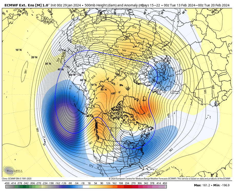
As for the - NAO arriving later in Feb, looks like game on.
-
2
-
-
4 hours ago, Heisy said:
From our Philly forum…
00z 06 GFS show a PV split btw right around mid month. If we have some blocking at that time could even enhance everything. Ensembles just stretch it, just seems everything is lining up at just the right time.
.
-
1
-
-
15 minutes ago, CAPE said:
It could go like that. It will be painful for some. The antsy and impatient will be regular visitors to the panic room lol.
CANSIPS for Feb . Basically cooler but seems like an extended dry period. Versus split flow in the long range by various ensembles.
I imagine need to see how high + the PNA gets.
Too much of a good thing and we might go drier.
-
34 minutes ago, Heisy said:
From our Philly forum…
00z 06 GFS show a PV split btw right around mid month. If we have some blocking at that time could even enhance everything. Ensembles just stretch it, just seems everything is lining up at just the right time.
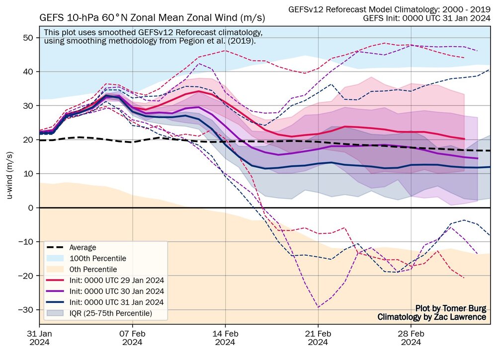
.The signal for the mid month weakening has been there for a bit combined with slower winds and a gradual movement of the PV Southward in a wobbling fashion through hours 384.
-
4 minutes ago, CAPE said:
It appears we are getting the 'ideal' pattern with all the teleconnections in the desired phase. With the coupled PNA/EPO ridge and the NAO ridge building westward and squeezing the TPV southward, the NS is going to be busy and chaotic. Tracking is going to be 'fun', with models struggling to resolve wave interactions and timing between the northern and southern streams.

I believe at the peak of the pattern and possibly afterwards for a bit we will have some bizarre storm evolutions, such as loops, stalls and retrogrades. Looks crazy.
-
1
-
-
8 minutes ago, psuhoffman said:
The local results could be similar and 1960 was an amazing late winter period, but 1958 is the better analog because it was a similar strength Nino. And you can see the similarities in the pacific to the coming pattern on the 1958 h5 composite below.

compare that to 1960 which was an enso neutral year and you see while there is definitely a similar nao blocking regime and subsequent eastern trough, the pacific pattern is not as close a match. It’s not way off but it’s lacking the canonical Nino central pac low, or at the least is muted.

This doesn’t mean the ground truth doesn’t end up similar but that’s why people are using 58 more than 60 as an analog. 2010 is an excellent analog to the coming pattern but obviously this is going to be displaced about 2 weeks later than 2010 which makes 1958 the best analog we have imo.Many photos online from the various snow storms of 1958 in our forecast area. Rather severe for many locations. If 1958 plays out its going get nuts.
-
 2
2
-
-
Latest trends with the AO are very encouraging. Also a weakening of the SPV mid February including a displacement event. HL progression in Early to Mid February is enticing for snow lovers in the East .
-
2
-
-
17 minutes ago, thunderbolt said:
Really this guys making a predicament, and it’s possibly 15 to 25 days away and even calling out possibly a major wow this guys got some big balls anybody know what this guy’s track record
He is a very well respected MET.
-
1
-
-
Some very cold air is going to be pulled down during mid Feb. Some crazy snow depths in Alaska and extreme cold.
-
2
-
-
From Tomer , here is his update from 5 days ago, so keep that in mind. He seems bullish for a Moderate to Major Mid Atlantic Snowstorm
January 25 Update I typically like to provide general windows for snow potentials once the picture becomes somewhat clearer; in the following days since this post, I feel increasingly confident in narrowing down a potential window between around February 15-25 for the peak potential of a moderate-major Mid Atlantic and Northeast snowstorm, though a low potential exists as early as the 2nd week of February.-
3
-
-
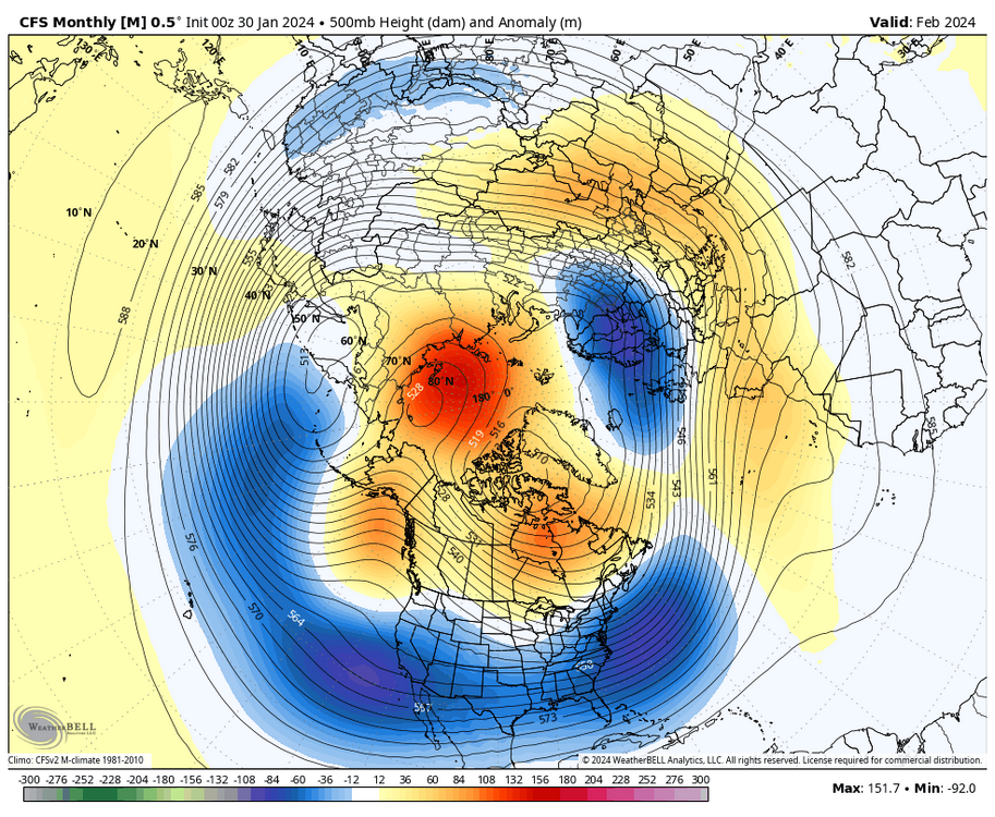
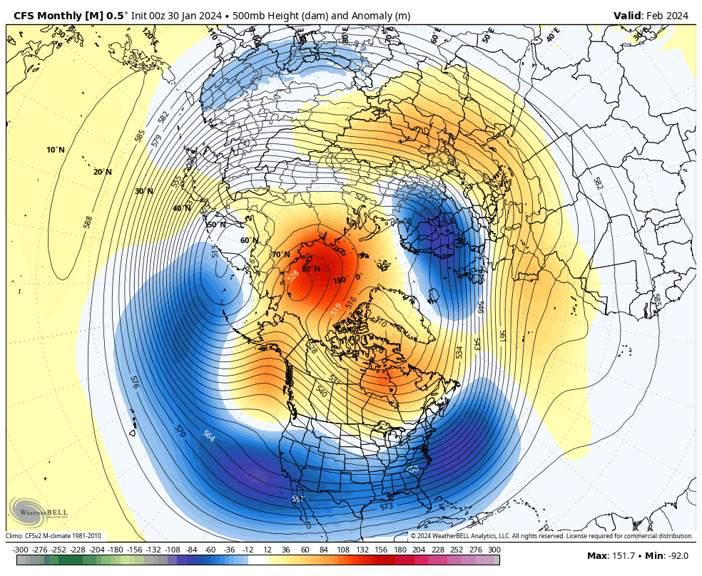
The CFS is in its wheelhouse of higher predictive scoring.
I can certainly see this as the look after Feb 10 to the 15th.
Based on the look overall the anomalies may be rather severe after Feb 15 th
-
4
-
-
7 minutes ago, WxUSAF said:
BAMwx smashing the torch emoji button like it’s the spinner on a slot machine
They will burn in flames !

-
2 minutes ago, Terpeast said:
President's Day window. Probably our last shot at the Big One as those have historically happened during this time frame. After the 20th, we'll be swimming upstream. Can still score then, just the max upside gets a bit smaller.
Looking at seasonality, blocking cycles, and other data, including the increased odds of another signifincant - NAO period, it would not shock me if we get that - NAO in early March. This might increase the odds of a higher end winterstorm in early to even mid March, despite climo aurguing otherwise.
-
2 minutes ago, psuhoffman said:
I like the PD period for our first BIG threat
Ha, love it. I am not sure if I like the term Big or First better ? ( I like both !!! ) Thanks for your updates psu.
-
Just now, brooklynwx99 said:
@psuhoffman this is the week after the EPS ends… it is timed up with the EPS perfectly at 360hr as well
Looks like big snow storm potential. Or too early yet ?
-
1
-
-
DT update
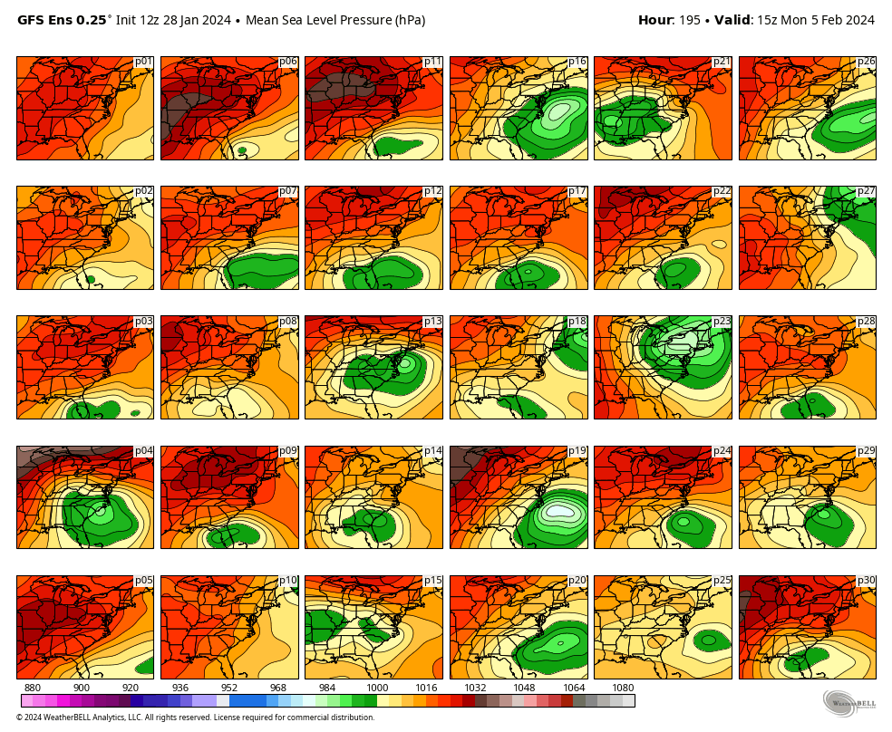
·9,047ViewsWORKING HYPOTHESIS so if we accept the idea that the northern Jet Stream is overdone then the southern LOW is not along the Gulf Coast on FEB 4-5 . It will be back in the Tennessee Valley and the big snowstorm threat is still alive. IMAGE 2 shows the individual 30 members of the 12z GFS Ensemble . Of the 30 members ….13 of them show a significant surface LOW that would bring significant snowfall to the Middle Atlantic region. some of these Solutions also include the northern Mid-Atlantic and New England. Some do not. Given the GFS propensity to overdo the northern branch and suppress southern systems 13 out of 30 is almost 50% which is not bad.


-
2
-
-
This would be a plus to hopefully extend or magnify the upcoming pattern change.
-
5
-
-
2 minutes ago, Terpeast said:
ULL is west on 12z EPS, still quashes the ss wave but getting closer to a phase. If this is a new trend, we’ll want to keep it going to get them phased. But like Heisy said, large scale changes are still likely to happen
Like many have stated, it is still a long ways off given the complicated set-up.
-
1 minute ago, Terpeast said:
ULL is west on 12z EPS, still quashes the ss wave but getting closer to a phase. If this is a new trend, we’ll want to keep it going to get them phased. But like Heisy said, large scale changes are still likely to happen
What does the EPS look like at the extended range?


Mid/Late February will be rocking. (This year we mean it!) February long range discussion.
in Mid Atlantic
Posted
You need to visit other forums in the East and conduct therapy, because if you think its a bummer here at times other forums are even worse. I totally get it though. Its been a very long time for some areas. I understand the frustration.