

frd
-
Posts
5,709 -
Joined
-
Last visited
Content Type
Profiles
Blogs
Forums
American Weather
Media Demo
Store
Gallery
Posts posted by frd
-
-
14 minutes ago, CAPE said:
Why post the control? The mean is a nice improvement.

Control is on acid most times. Microdot city.
-
 1
1
-
 1
1
-
-
9 minutes ago, AtlanticWx said:
it's march bro what do u expect
It can snow in March bro
-
1
-
-
7 minutes ago, CAPE said:
At this point the weekend storm does not look like it will come together in such a way that the combo of enough cold air and precip will coincide. Far north/west areas obviously have the best shot at some snow.
Do you still have hope for us in the lowlands near the 15th to the 20th? Personally I enjoyed being outside on Saturday doing some landscaping.
-
1
-
-
2 hours ago, psuhoffman said:
Euro wave 2 it is…


Even with off shore low to the SE still rain far inland. Nothing here . Pathetic winter.
-
1
-
-
42 minutes ago, Weather Will said:
Great pattern change….WB 12Z GFS thru Day 10.

Snow map are correct 2 % of the time below 45 degree North
-
1 minute ago, Maestrobjwa said:
But did the niño ever really couple though?
No, and the cycle that year was for the MJO to hyper speed into the warmer phase.
-
1 minute ago, psuhoffman said:
The pacific Hadley cell has expended and shifted north
As I mentioned seems everything, cause and effect wise, has shifted North in the last several years. Mostly effecting the mid lattitudes..
-
15 minutes ago, psuhoffman said:
The SER is being fed by more than just the pac and because if it any wave that comes off the pacific amplified way to our west.
I read that the Atlantic SST profile has rapidly warmed the last three years.
-
1
-
-
2 minutes ago, psuhoffman said:
The blocking is having the typical response. The wave yesterday turned southeast after cutting. There is a wave early next week that is forced to turn southeast. The trough in the west is eventually forced east. It’s just all happening way too far north for us. And this has been true of almost every block the last 5 years. Extreme blocking is supposed to be good for the mid Atlantic. Historically it’s bad for New England. But lately northern New England has been winning big with blocks and we just get colder rain.
Maybe typical responses are just further North now due to climate warming? Strong West NAO blocks ? Davis Straits only benefit upper NY state and Maine?
-
1
-
-
1 minute ago, psuhoffman said:
The blocking is having the typical response. The wave yesterday turned southeast after cutting. There is a wave early next week that is forced to turn southeast. The trough in the west is eventually forced east. It’s just all happening way too far north for us. And this has been true of almost every block the last 5 years. Extreme blocking is supposed to be good for the mid Atlantic. Historically it’s bad for New England. But lately northern New England has been winning big with blocks and we just get colder rain.
Why are the blocks not delivering? It is the Nina base state? AMO or North Atlantic warm pool ?
-
1 minute ago, LP08 said:
This isn’t prime position to say the least.
Persistence wins. One last chance near the 15 th to the 20 th. Incredible inland and far NW snowstorms the last three years. We need something to re-set the pattern.
-
2 minutes ago, Cobalt said:
To help put things into perspective

OMG !!!!
-
2
-
-
3 minutes ago, CAPE said:
Game over right here. The energy associated with that vorticity lobe stuck between/underneath the 2 blocks has to dig south, and it phases in.

A chapter from the PSU 101 " How not to get snow when the pattern looked promising" Cliff notes available on Amazon.
-
1
-
-
1 minute ago, CAPE said:
Lets look back a few runs on the GFS before more energy was dumping into the western trough in response the the amplifying EPO ridge because it cant escape west. What do you notice?


flatter ridge , then pop , ying yang
-
1
-
-
2 minutes ago, DarkSharkWX said:
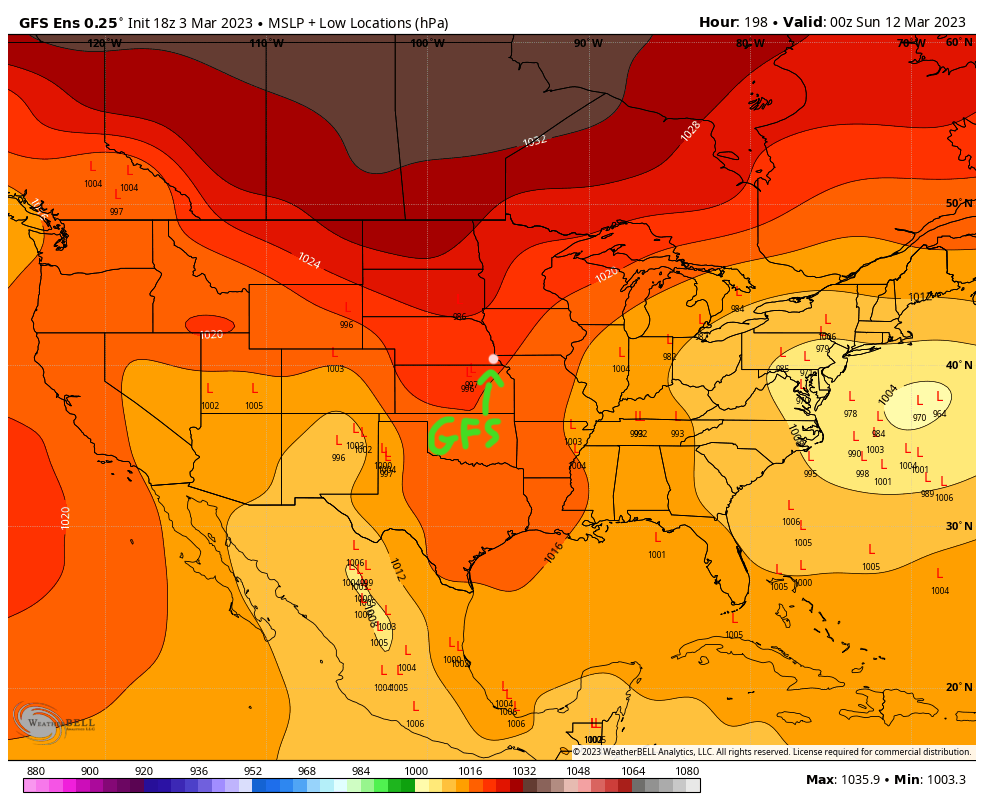
as expected a lot of spread

Fits the persistance of low pressure tracks for the past several years. Inland to our NW.
-
2
-
-
Just now, Stormchaserchuck1 said:
Look at this monster pattern.
When is the MECS ?
-
7 minutes ago, Heisy said:
My concern at 6z seems valid again. We just don’t want that strong of a shortwave coming east idc what anyone says s Yea maybe NE it doesn’t matter, but here it does. This will likely cut even though the block is doing its best
.You have had a hot hand @Heisy Looks like may need to wait for my area until after the 14 th, or maybe 2024. The constant inland tracks persist. Nothing new here.
-
 1
1
-
-
1 minute ago, psuhoffman said:
You all are going to lose your minds if you get too invested in each solution every 12 hours right now. The pattern is loaded. We will have threats. Probably multiple. Hopefully we get lucky and one is a flush hit. But the final solution to any of these threats won’t show itself yet on guidance. The pattern is way too noisy.
This isn’t a Nino split flow blocking regime where the NS is quiet and we guidance simply has to time up the STJ waves. This pattern involves too many wave interactions for guidance to nail details at long leads.
Some thought I have on this pattern…we have multiple ways to score. If the initial wave fails it could pull the boundary south for the next one. That seems our most likely win. If it holds back it could eject waves that might get us. This wouldn’t be a big storm scenario but boundary waves can be respectable in March. About the only total fail would be if all the energy ejects and phases into a March 93 type event but cuts. Then we get rain and cold dry after and since everything gets bundled once it lifts the whole pattern could break down. If this does end up ejecting all the energy and bombing while exciting that might be our lowest snow probability scenario. Most upside though. Pick your poison.
@psuhoffman when in your opinion does the threat window end ? I was thinking the 20 th, what our your thoughts ? By the way, I am glad you are excited. I hope I can excited too at my lattitude in the lower lands.
-
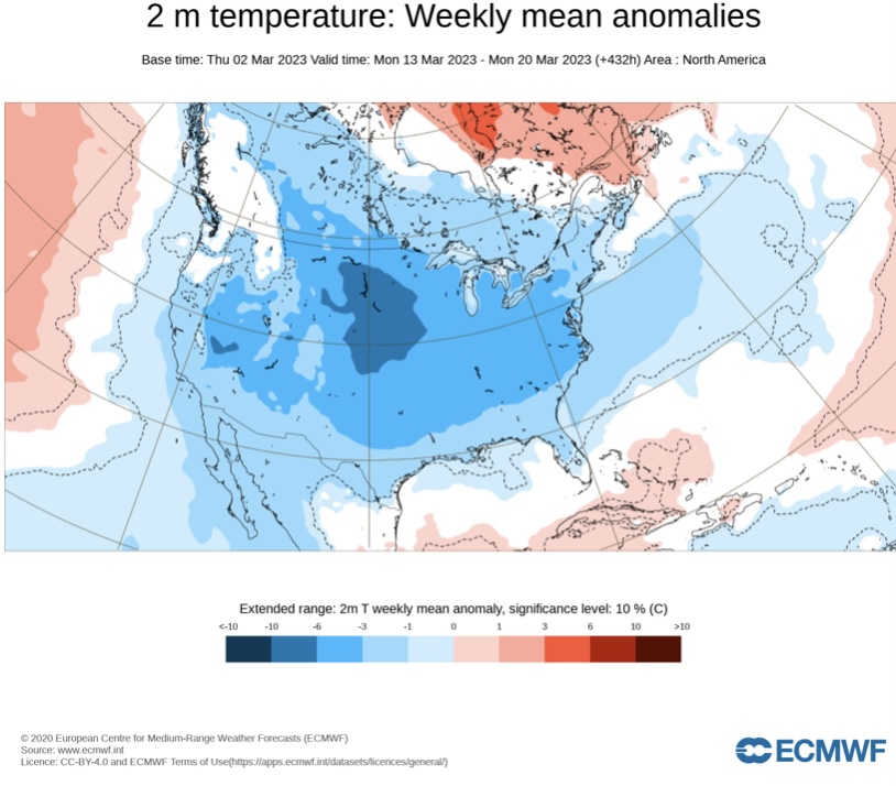
From Don Sutherland :
The latest ECMWF weekly forecast for March 13-20 maintained the longstanding cold idea. That might offer the Mid-Atlantic region its best opportunity for at least some snowfall.
-
2
-
-
1 hour ago, Ralph Wiggum said:
Define "up North".
The NYC forum
-
 1
1
-
-
5 minutes ago, WinterWxLuvr said:
97-98 style
Lets hope not, but hope it plays in our favor.
-
Nino cometh
-
2
-
-
The threat window

-
5 minutes ago, CAPE said:
Inverted trough look.

Some posters up North are fearful of surpression despite the modeling and recent history of far NW tracks.


March Medium/Long Range Thread: The Empire Strikes Back
in Mid Atlantic
Posted
Nearing this date and beyond is a nice + PNA spike.