

frd
-
Posts
6,523 -
Joined
-
Last visited
Content Type
Profiles
Blogs
Forums
American Weather
Media Demo
Store
Gallery
Posts posted by frd
-
-
56 F here.
Great late day sun, excellent dog walking weather.
-
Sky is brightening here. Very surprised.
-
Looking to the core of the summer it may not be as hot in the East as some have forecasted.
The core of the heat is out West and in the Plains.
Indications as well that there will at least be the potential for some rains in the East, however, very dry in the center of the Country.
.thumb.jpeg.ed76992e97e021253c094295e60b1748.jpeg)
-
 3
3
-
-
Most of country nice, except our area, socked in by clouds from the still cold near-by Atlantic and Easterly flow.
Perfect view of the low level stratus clouds
https://www.star.nesdis.noaa.gov/GOES/conus_band.php?sat=G16&band=GEOCOLOR&length=24
-
1
-
-
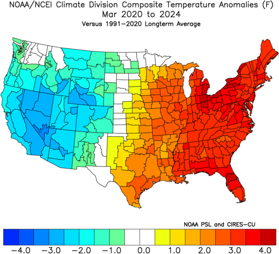
Interesting that recent March months have been way too warm for snow, borrowed this from bluewave.
It was safe to say that with the collaspe of the - AO snow probabilities in March were pretty nill.
The cold stormy window has shifted out West this month, but overall totally went poof. Many areas of the country were in the 70's two days ago.
.thumb.jpeg.5ca3498352000c19c5a210d6f1048b47.jpeg)
-
 1
1
-
-
super evident passage here

-
2
-
-
Back door front moved through last hour. Temp drop to 45 F and winds East at 12 mph.
-
6 minutes ago, Eskimo Joe said:
You can see the back door cold front edging into Delmarva. Delaware and Maryland mesonets showing a quick shift to ENE winds and temps falling into the upper 40s.
My location the winds are still South.
Interesting, I do not see any cloud cover in normal sat view, or even enhanced. Sat does show the East to West sunset .
-
Moderate wind threat later Sunday and Sunday night.
Mount Holly AFD
LONG TERM /SATURDAY NIGHT THROUGH WEDNESDAY/... Strong low pressure lifts into Canada, and this drags a strong cold front through the Great Lakes Saturday night, and will be over the Ohio Valley down through the Gulf Coast states on Sunday. A tight southerly pressure gradient will develop between high pressure over the Atlantic Ocean and low pressure north of the Great Lakes over the Northeast and Mid-Atlantic. Strong winds aloft will be associated with this approaching system, with a potential 50 to 60 kt low level jet that moves across the region Sunday afternoon and evening, and then a 100+ kt jet streak following behind Sunday night. During the day, south winds will increase to 20 to 30 mph with 35 to 45 mph gusts. A Wind Advisory may be needed. -
I love this weather without bugs so far. Excellent day for a walk, run or bike.
-
1
-
-
Thinking ahead to surfing and body boarding it apears the beach replenishment off of my fav spot in North Wildwood NJ has settled over the winter months reducing the sand bar and allowing waves to pass over and then break in the near by surf zone.
I am very excited to think about mid June as a starting point to go in without a wet suite.
https://northwildwood.com/north-wildwood-surf-cams/
This morning looks pretty there.
here are the obs
6/5mm wetsuit
44
°F
 49ºF
49ºF
Waist to head
3-5FT
POOR TO FAIR
2.8FT8sSE125º0.8FT2sNNE21ºCross-shore wind
13ktsNNE
27kts gust
-
21 minutes ago, mappy said:
 Me too friend, me too.
Interesting that a UV index of 3 to 4 after winter can really give you a burn in little time.
Skin tone ( olive complexion ) can add time before you burn, maybe upwards of an hour.
But, we are only going up now so get ready for much higher UV index in the month aheads.
Tampa, Fla. already at a 10 index today.
Here is a cool link
https://www.cpc.ncep.noaa.gov/products/stratosphere/uv_index/bulletin.txt
OAA/EPA ULTRAVIOLET INDEX /UVI/ FORECAST NWS CLIMATE PREDICTION CENTER COLLEGE PARK MD 223 PM EDT TUE MAR 11 2025 VALID MAR 12 2025 AT SOLAR NOON /APPROXIMATELY NOON LOCAL STANDARD TIME OR 100 PM LOCAL DAYLIGHT TIME/ THE UV INDEX IS CATEGORIZED BY THE WORLD HEALTH ORGANIZATION AS FOLLOWS: UVI EXPOSURE LEVEL 0 1 2 LOW 3 4 5 MODERATE 6 7 HIGH 8 9 10 VERY HIGH 11 AND GREATER EXTREME FOR HEALTH RELATED ISSUES: WWW.EPA.GOV/SUNSAFETY FOR TECHNICAL INFORMATION ABOUT THE UV INDEX.... GO TO THE NATIONAL WEATHER SERVICE UV INDEX WEB PAGE: WWW.CPC.NCEP.NOAA.GOV/PRODUCTS/STRATOSPHERE/UV_INDEX CITY STATE UVI CITY STATE UVI ALBUQUERQUE NM 5 LITTLE ROCK AR 6 ANCHORAGE AK 1 LOS ANGELES CA 5 ATLANTIC CITY NJ 4 LOUISVILLE KY 5 ATLANTA GA 7 MEMPHIS TN 6 BALTIMORE MD 4 MIAMI FL 10 BILLINGS MT 3 MILWAUKEE WI 5 BISMARCK ND 3 MINNEAPOLIS MN 4 BOISE ID 2 MOBILE AL 9 BOSTON MA 4 NEW ORLEANS LA 9 BUFFALO NY 4 NEW YORK NY 4 BURLINGTON VT 4 NORFOLK VA 6 CHARLESTON WV 5 OKLAHOMA CITY OK 4 CHARLESTON SC 7 OMAHA NE 4 CHEYENNE WY 5 PHILADELPHIA PA 3 CHICAGO IL 4 PHOENIX AZ 6 CLEVELAND OH 3 PITTSBURGH PA 4 CONCORD NH 3 PORTLAND ME 4 DALLAS TX 7 PORTLAND OR 1 DENVER CO 4 PROVIDENCE RI 4 DES MOINES IA 4 RALEIGH NC 6 DETROIT MI 4 SALT LAKE CITY UT 5 DOVER DE 4 SAN FRANCISCO CA 1 HARTFORD CT 4 SAN JUAN PR 11 HONOLULU HI 10 SEATTLE WA 1 HOUSTON TX 8 SIOUX FALLS SD 4 INDIANAPOLIS IN 4 ST. LOUIS MO 5 JACKSON MS 8 TAMPA FL 10 JACKSONVILLE FL 9 WASHINGTON DC 4 LAS VEGAS NV 5 WICHITA KS 5 -
5 minutes ago, mappy said:
Sure is! The site is about 10min from my house, so spent the afternoon helping them put it all together.
That was nice of you ! Yesterday was a spectacular weather day if you love the sun and warmer temps !
-
1
-
-
3 minutes ago, mappy said:
Such a great experience! Rocking a sunburn today too haha
Is that you in the video mappy ?
By the way, that looks like an awesome site, and what a lovely view all around.
-
Interesting still below 60 F here. other stations much warmer. Reading PA, and Baltimore at 63 to 64 degreeF
-
6 hours ago, Ji said:
Dr no say noWPC still going bullish with rainfall.
Mount Holly AFD going with likely probs for rainfall ( heavy showers with thunder ) on Sunday and Sunday evening with the passage of the cold front, then much cooler and drier. Severe potential at this point seems limited, but worth monitoring as stated in the AFD.
-
Increasing odds for significant rainfall on Sunday
.gif.02d900b0e7d7e5449d8ec6231770b8d1.gif)
-
1
-
-
On 3/7/2025 at 7:15 AM, WxUSAF said:
Feels like we’re going to need to have one of those May/June periods with just training storms with tropical moisture levels to finally break out of this long term drought.
Last two years epic rain events in May to early July combined with early season humidity to yield tomato blight and other garden issues.
Will be interesting to see what this summer provides rain-wise.
-
Got some help from a couple University master gardens and suggested blight resistant tomato plants.
I pre placed order from Burpee. Hoping for better results this year. Also changing the location as well.
-
2
-
-
37 F. Here. Rather chilly at the local Wawa.
Looking forward to an awesome high of 64 today.
-
SE cashes in again. Going to get dry again here.
.gif.c60c2a756d87defd43429ae3d36d46f9.gif)
-
6 minutes ago, Ji said:
great use of a -NAO
-NAO is useless without other drivers lining up this time of year.
Next winter should be interestng.
-
1 hour ago, CAPE said:
Looking Spring-like next week. 60s and probably low to mid 70s for a couple days.
Models showed warmth from two weeks ago, snow threats were never going to happen with the AO sky high and no real useful blocking. Starting to get the WAR up and running.
Onto to real Spring weather.
-
1
-
-
16 minutes ago, CAPE said:
I agree. That was a damn cold airmass and the thermal boundary was modeled to be suppressed along/ just off the SE coast. The complicated part was the TPV lobe and the possibility of enough interaction to lift the developing low northward. There was a general lean across the ens runs of favoring areas SE of our region for significant snow overall, despite op runs depicting big snows further north with the possible phase. The EPS was probably the biggest offender initially depicting a large area of 6-8" on the snow mean across our area for a few runs in support of the big snows advertised on the Euro Op, before trending SE. None of the models came close to nailing the final outcome until closer to game time though. It was more of a gradual shift over multiple runs.
Most model busts happen in a Nina. This winter was notorious for rather dynamic TPV movements and non-movements.
.jpeg.570d27211871294a6d4c9c9da36ad716.jpeg)
.jpeg.c275448ee5f73d5e7796c7e7dc535f74.jpeg)
March Medium/ Long Range
in Mid Atlantic
Posted
Has not been for 7 long years. Yawn......