

frd
-
Posts
7,191 -
Joined
-
Last visited
Content Type
Profiles
Blogs
Forums
American Weather
Media Demo
Store
Gallery
Everything posted by frd
-
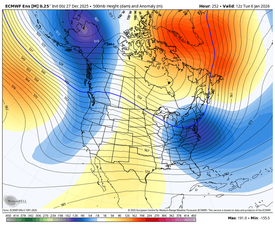
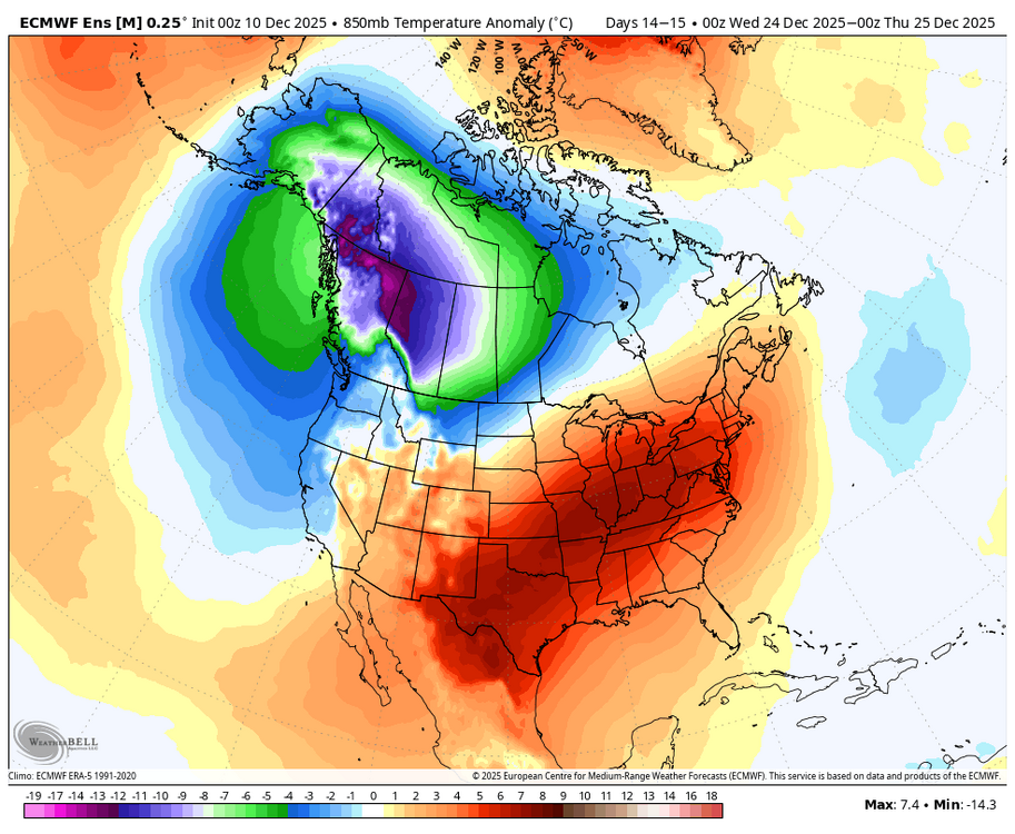
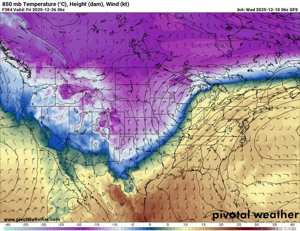
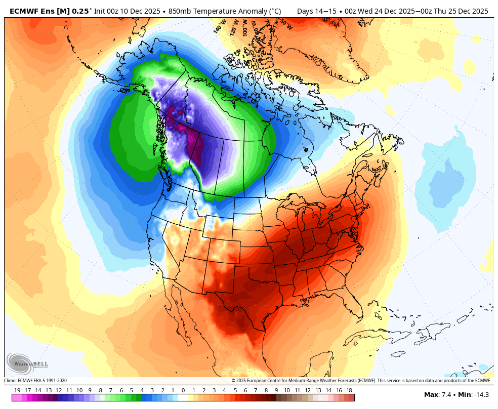
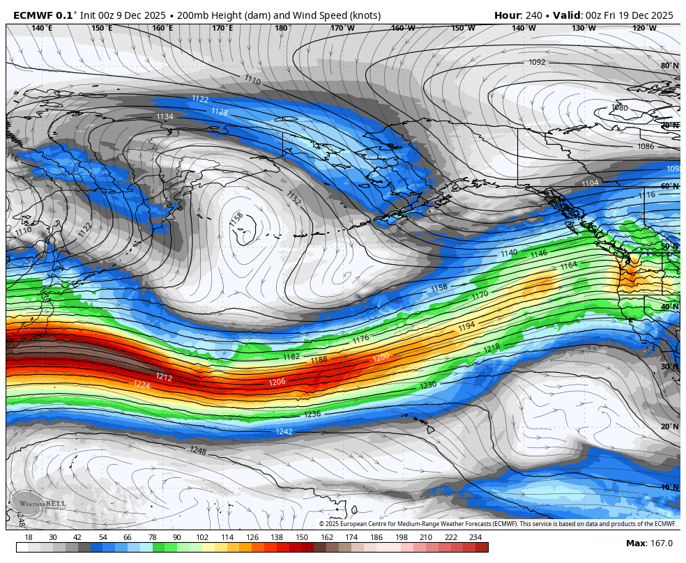
Allan talks about the transition period and how the pattern may evolve going forward. There seems to be more concensus about a mid month warm-up ahead of the improving Pac. We shall see. Allan Huffman @RaleighWx · 1h 1) As others have posted today, this look around 1/7 could be conducive to a potential East Coast winter storm. A west-based -NAO, a deep trough axis along the East Coast. We do lack a western NA ridge to really push cold air south though. If we can get a s/w to drop into the Deep South/TN Valley far enough SW it could help pop a low near the SE/mid-Atlantic coast. Certainly no guarantee but the chance is there. 2) I do think in general the period between 1/5 and 1/15 or so will see a transition to the overall long wave pattern. On today's 12z EPS, notice we see a ridge over Central Asia, a trough into east Asia and a ridge builds downstream over western North America. We could even see perhaps a Kona Low go into Hawaii which would re-enforce potential blocking ridging over the NE Pacific and provide an active subtropical jet stream. I do think this goes to a solid -EPO by mid-month. Show more Allan Huffman @RaleighWx 3) However in this transition period say day 12-17 or so, we could see milder temps for a few days across much of NA as the cross-polar flow temporarily shuts off. The west-based-NAO though may keep the Lakes/East normal or a little below normal. But our source region in Canada will warmup and will need some time to replenish the cold air via cross-polar flow. 4)Todays EC46 shows how this could play out and by weeks 3/4 we see a cold looking pattern with cross-polar flow, a -EPO/-AO/-NAO look and the cold air replenished in Canada. This would take us into late January. So I do think the 2nd half of January look promising for cold/snow in the East. We shall see!
-
BAM Weather @bam_weather · 1h The type of set-up into the second week of January won't be one that favors major arctic cold, but can offer up increased winter storm potential for the East Coast. No signs of this strong -NAO set up breaking down any time soon. Top analogs into January based on the Polar Vortex and Tropical Forcing also support the idea of a favorable set-up for snow in the lower OH/TN Valley regions and the Mid-Atlantic. Eventually as convection once again traverses the equatorial Pacific Ocean, we should see the Alaskan ridge (-EPO) rebuild and allow for a more widespread/consistent shot of cold air across the US mid-late January. The EPS Weekly is already hinting at this idea. Stay up to date with our Energy Reports on the pattern ahead here: https://bamwx.com/register/energy-commercial/
-
Banana High, peak climo, cold Canada and the outcome still sucks. Yes its at OP at 348 hours, LOL.
-
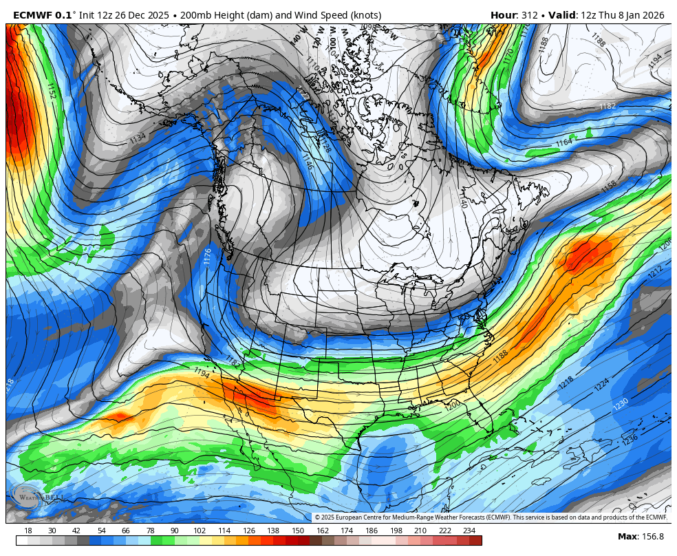
Finally some improvement in the PNA
.thumb.png.c24147e973d24e0e46d6a73a3a9f6368.png)
-
Eric is very excited about the snow potential for the Mid Atlantic Jan 6 th to the 11 th Eric Webb@webberweather This pattern has real big dog potential, esp in the Mid-Atlantic. Very El Niño-esque here with the Pacific trough & -NAO coupled with a strong subtropical jet. The strong subtropical jet is a lagged effect from the big MJO event over the Indo-Pacific in late Nov & early Dec.
-
Yummy
-
Once again the trend of cloudy days continues next week. More cloudy days, versus sunny days that started earlier this Spring. Bad enough its cold without snow, but then to deal with shorter days and no sunshine. Saturday Mostly cloudy, with a high near 35. Northeast wind 5 to 10 mph. Saturday Night Mostly cloudy, with a low around 25. Northeast wind around 5 mph becoming calm. Sunday A chance of rain after 1pm. Cloudy, with a high near 44. Calm wind becoming south around 5 mph in the afternoon. Chance of precipitation is 30%. New precipitation amounts of less than a tenth of an inch possible. Sunday Night Rain likely. Cloudy, with a low around 38. Chance of precipitation is 60%. New precipitation amounts of less than a tenth of an inch possible. Monday Showers, mainly before 1pm. High near 59. Breezy. Chance of precipitation is 80%. Monday Night Mostly cloudy, with a low around 26. Tuesday Cloudy, with a high near 36. Breezy. Tuesday Night Mostly cloudy, with a low around 25. Wednesday Mostly cloudy, with a high near 39. Wednesday Night Cloudy, with a low around 23. New Year's Day Cloudy, with a high near 34. Thursday Night Partly cloudy, with a low around 17. Friday Mostly sunny, with a high near 30.
-
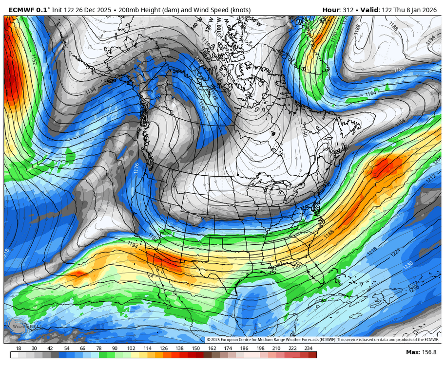
Some STJ action maybe
-
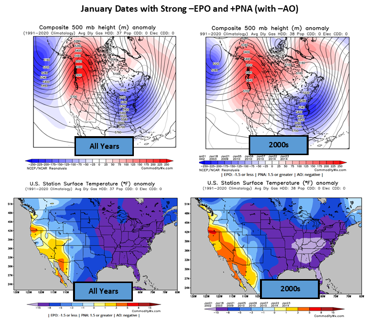
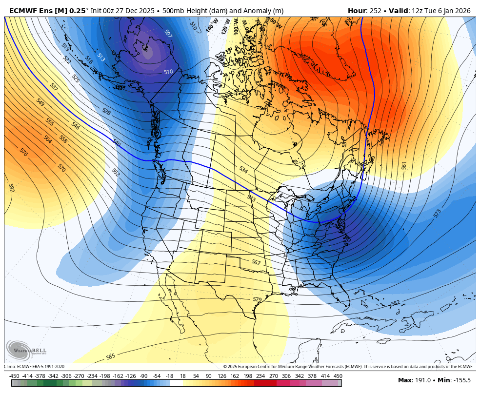
Commodity Wx Group @commoditywx Euro weeklies have strong -EPO and +PNA with -AO conditions by 3rd week of January, which would favor another big cold outbreak (1/23 EIA week).
-
Interesting trends centered on this time period. https://x.com/i/status/2004599913410081210
-
Do you believe in the Jan mid month warm up before the pattern realigns with an improved Pac? Seems the best Jan snow potential is Jan 6 th to the 10 th, and then after Jan 18 th.
-
Merry Christmas to everyone.
-
Atmospheric River of snow, incredible!
-
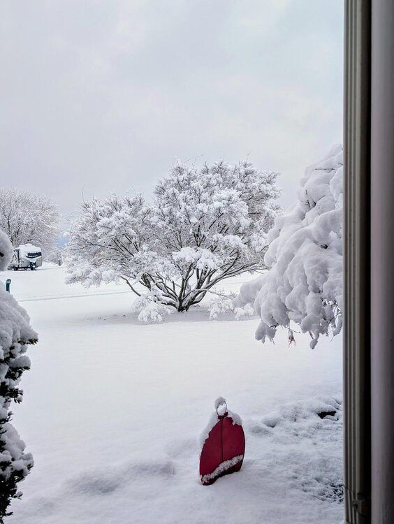
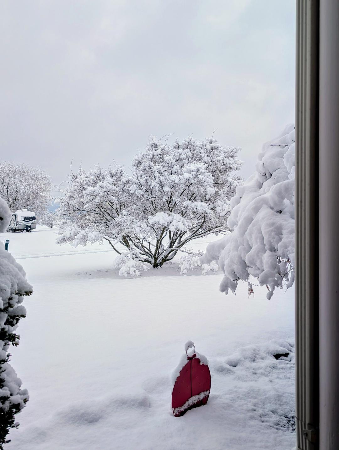
4 inches here , a very wet snow, but very pretty. Our greyhound enjoyed prancing in the winter wonderland.
-
3 to 4 inches would be heavenly !
-
Thats fine with me. I read previous times where Decembers that featured a mostly -PNA have a following Jan with a overall + PNA. Hope that repeats next month, along with some timed moisture. Even a little snow would be nice.
-
Merry Warm up. Need to go back in time to get even a normal winter. I miss you Nor'easters and SECS/ MECS .
-
Given the proper set up it could have been a SECS, but alas the Pac did not allow it. At that time we did have a - AO and a -NAO. But the PNA was upgly.
-
Happens every year around the 22 nd of December like clockwork. Not surprising really, although we have a stout - WPO there is too much Pac jet momentum. The Pac always rules as seen the past two weeks with a - AO and a - NAO and still nothing to show for it. I don't really care what folks say about climo as we had extreme cold air in Canada and a - AO and a - NAO, but in December you need a good PAC and a + PNA . We lost out because of the PNA.

-
Euro seasonal is warm generally in the January to March period.
-
He rebranded!
-
GEFS also trending to a better, taller + PNA, hope it happens !
-
General odds of a moderate accumulating snow, at least should increase, the next 15 to 25 days with the - SOI dive and a re-set of the MJO.
-
Snow started here an hour ago. Nontreated surfaces have a coating currently. Looks winter-like. 27 F.
-
Rather dramatic drop in the AO forecast during the past 24 hours.
.thumb.png.323b78f0c4d57ef685159b4b80548620.png)


.png.25bf44fd65b9f2ab14c205d2b6ac56b7.png)


.png.1ad15cdd1219285a915289b710dd00fc.png)