

WxUSAF
-
Posts
24,682 -
Joined
-
Last visited
Content Type
Profiles
Blogs
Forums
American Weather
Media Demo
Store
Gallery
Posts posted by WxUSAF
-
-
Gfs is funny. Through 90hrs, I would have definitely said it would be a better outcome for us than 12z even. CAD is stronger, weaker OH valley primary, confluence a tick more, and shortwave deeper.
I think the reason it comes so far inland is maybe the shortwave becomes negatively tilted a little sooner than we’d prefer? I don’t see much else. All within the range of possibility I guess.
-
 3
3
-
 1
1
-
 1
1
-
-
5 minutes ago, CAPE said:
HH GFS is going to send the entire board into a drinking binge.
Yeah it’s rough. But lots of time for things to shift back in a good direction. Or go to all rain.
-
Low goes over St Mary’s MD. That’ll do it.
-
1
-
1
-
-
1 minute ago, AmericanWxFreak said:
Welp
That previous map for 0z Thursday is the rough one. That one shows a lovely CCB ala the euro.
-
1
-
-
37 minutes ago, CAPE said:
I have some egg nog spiked with rum, bourbon, and brandy. Can only drink this shit between Thanksgiving and New years. Its a rule.
Sounds good. Pass me one
-
Thanks @psuhoffman and @MillvilleWx for the analysis! Onto hopefully happy hour
-
3
-
-
Just now, psuhoffman said:
I’m late to the party and probably 150 posts behind...but it hits the wall of confluence and turns due east just in time to save DC north. Keep in mind euro is typically the most amplified model (sometimes a little too amplified) so seeing it slightly north of other guidance (initially) isn’t shocking.
Hopefully the over amplified bias is playing by with the EPS as well.
-
2
-
-
Euro looks quite nice to those of us who accept that this is very likely going to mix. I want that CCB.
-
1
-
-
Euro a little weaker and a bit south vs 0z.
-
1 minute ago, Scraff said:
And a 12 pack of Corona.

6 pack of corona light
-
 1
1
-
-
2 minutes ago, NorthArlington101 said:

Crazy uncle shows up to the party late with generic chips and salsa
-
1
-
1
-
-
Definitely seems likely you all get on the board with an appetizer.
-
10 minutes ago, CAPE said:
Yeah I noticed that. Has it further west this run but nearly the same result. Not really a deeper low at that point either. Odd, ofc it is the CMC lol.
50mi wobbles are well within the noise even down to t-24hr. All in all pretty consistent. Hopefully it’s consistent for good reasons lol.
-
7 minutes ago, PhineasC said:
Biggies always mix around these parts. I will take a couple hours of sleety snow here if it means I get 15-20" overall. That's the tradeoff that has to occur. No big deal.
I’m selling on those kind of totals due to the speed of the storm. Ggem with like 5-10 hours of 2”/hr rates? Doubtful. Maybe our west where ratios could be better.
-
3
-
-
Lol I just don’t see how you get big accumulations Monday. Even for you M-D line folks, this seems like 5:1 ratio slop. And the moment it lightens up its back to rain and melt. Hope I’m wrong. I’ll hope for some festive white rain while watching mondays 12z euro.
-
3
-
-
2 minutes ago, Buddy1987 said:
From your experience do you think nw banding will increase as we get closer farther to the south/southwest for NC foothills/VA and up into you all?
There’s always banding features. Tuesday is the time to analyze those. N/W always favored.
-
1
-
-
Just now, CAPE said:
At this point not sure there is much that can change it. Yeah a flatter wave could do it- but probably not likely. A bit stronger confluence/suppression/stronger high up north is the best answer, or...the low bombing further south and a tad less tucked.
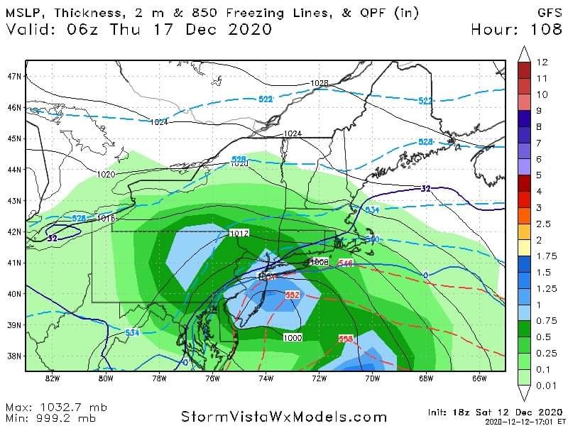
Ggem has the low track like right over OCMD. Assumption with a track like that should be mixing to the fall line AT LEAST. Gfs actually has the more classic 50mi east of OCMD track for an all snow storm.
-
Catching up. Gfs and ggem are classic mid-Atlantic MECS. Not much to say. Verbatim ggem gives me 11” in 6 hours Wednesday afternoon. As much as that would thrill my weenie soul, I’ll take the under and hope I’m wrong.
Snow starts in under 4 days...stay on target.
-
3
-
-
Dang like 1.5” of rain or more on gfs. Juicy.
-
Lol another gem
-
1
-
2
-
-
The late night crowds anthem
-
2
-
-
8 minutes ago, osfan24 said:
Mixing is obviously always a concern, and I'll be interested to see how my move from Southeast Elkridge to the far western portion of Ellicott City makes an impact. However, I didn't mix even in my old location in December 2009, the two February 2010 storms or the January 2016 storm. I mixed back in 2003 in College Park, and 1996 in the Baltimore area. Obviously, December mixing is more of a concern than later in the winter given climo, but I won't start getting concerned until Monday if the mixing is still showing up. We just don't get many storms around here, especially coastals, where we get around a foot or so of snow. Certainly nothing in recent memory that I can remember. It's either a mauling of around two feet, give or take, or not much. I guess February 2014 and January 2011 could fit the bill sorta/kinda.
Going to be a noticeable difference almost certainly unless the ggem scores a coup here.
-
7 minutes ago, JakkelWx said:
Seriously?
100%
-
4
-
-
Just now, WxWatcher007 said:
I lived right in the middle of the pit too back then (2014). Nothing comes easy.
All that said, if we can’t get a megalopolis snow in this pattern, we should cancel winter now. You can’t do much better than this other than shifting the pattern to January 17th.
Yup. This is the best December pattern in years. Well, we had an excellent pattern 2 years ago and RIC on south cashed in.
December Medium/Long Range Discussion
in Mid Atlantic
Posted
Eh, don’t really see that. Either way, all pretty subtle changes that disappoints a lot of us in this particular case.