

WxUSAF
-
Posts
24,682 -
Joined
-
Last visited
Content Type
Profiles
Blogs
Forums
American Weather
Media Demo
Store
Gallery
Posts posted by WxUSAF
-
-
1 minute ago, Eskimo Joe said:
So far, the 12z Euro looks better for the 12/16 event at 500mb. Better confluence, and western ridge.
I don't hate it so far, that's for sure
-
3 minutes ago, losetoa6 said:
Monday looks a bit quicker coming in
Strong and warm. High pressure out west definitely jumped west at 78hrs, which is nice to see.
-
Just now, North Balti Zen said:
@WxUSAF didn't want to clutter the long range thread - but Jan. 2019 was a major disappointment for sure Baltimore north. We definitely did not verify warning criteria and it was amazingly painful that day to see the snow hit a wall and all good rates fall about 15 -20 miles to the south. I believe I measured somewhere in the 4" range for that storm.
Yeah, I hear you.
That evening band was pretty strange. Developed in the NoVA burbs and slowly moved east. I remember watching it on my phone and thinking it wouldn't make it to MBY. Then it arrived and just dumped pure fluff dendrites for a few hours. A 6"+ difference between BWI and me is pretty weird, so that shows how close I was to the edge.
-
8 minutes ago, mattie g said:
I guess we can ignore the absolute monster that blows up at bit north and east of us on Christmas Eve. I mean...it's a long way out there, but...
Holy fack
The entire rest of the GFS run had potential. But bird in hand and all.
-
Just now, H2O said:
What stage is drinking? is that after acceptance?
Drinking is in all the stages.
-
 1
1
-
 1
1
-
-
Just now, leesburg 04 said:
now what?
We go through the stages of grief until by Tuesday we convince ourselves that 0.2" of slush that gets washed away is all we really ever expected and wanted.
-
 3
3
-
-
Just now, Maestrobjwa said:
Don't ya mean the southern chunj DC definitely...but Baltimore north? Fell just short (BWI literally measured 4.8"--so it was trolling with being .2 inches shy of verification, lol)
I had over 11". That evening band stopped just a few miles east of me.
-
8 minutes ago, losetoa6 said:
Ukmet is more progressive and weaker with the coastal low for Wed fwiw.
Think that's a fairly big adjustment on the crazy uncle?
-
6 minutes ago, Cobalt said:
fyp
Speaking of which, is this the last time we've actually been tracking a potential WSW event in the medium range since March 20-21 2018? The Jan storm wouldn't count since all positive trends were basically short range. Even March 20-21 didn't verify, so maybe the last one since Jan 2016??
Jan 2019 verified WSW for a good chunk of the area
-
1
-
-
1 minute ago, H2O said:
I think its safe to say today's model runs will hold for.....checks calendar...5 more days
GFS gets snow in at like 118hrs. That's Day 4 sucka.
-
1 minute ago, Always in Zugzwang said:
Hopefully in a couple of hours, we can also sing "God save the Queen!" when the Euro comes out!!
Euro coming in to join the party!

-
3
-
-

-
1
-
4
-
-
1 minute ago, LeesburgWx said:
CMC snowmaps incoming?
NSFW
-
1 minute ago, mappy said:
I'd feel so much better if the Icon was onboard
????
Looking good to me

-
1
-
7
-
-
GGEM incoming

-
 4
4
-
-
Just now, H2O said:
That HP getting back over MN is nice
Yup, all part of the same process. We don't want the HP outrunning the low. Want the HP on top of the LP like a hat. Maybe a bit ahead of the LP.
-
4
-
1
-
-
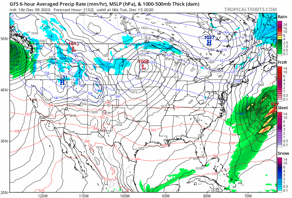
GFS evolution is just textbook for a Mid-Atlantic snowstorm. Gorgeous.
Look at how it's trended with the cold push out WEST over the Plains. Follow the 522 or 528 height lines in this gif. That push keeps the primary low from amplifying to our west. It can't get north, so it stays weak until it transfers energy to the coast. THIS IS WHAT WE WANT. This is nearly as important as having cold air in place east of the mountains.
-
6
-
5
-
-
2 minutes ago, H2O said:
Phew. I think things are ok based on 18hr GFS
Every model run is basically this

-
3
-
-
5 minutes ago, high risk said:
I honestly don't blame WB or TT. The problem is that NCEP doesn't generate true snow accumulation output for any models except RAP and HRRR, so it's up to the user to assign and apply an SLR. This is going to be addressed going forward.
Good to hear! Are they going to output what SLR they're calculating as well as the accumulation? That way we weenies will just adjust upward
")
-
1 minute ago, high risk said:
In these events with very marginal temperatures, the Tropical Tidbits accumulated positive snow depth change are the best maps to examine. They show what the model believes can actually accumulate on the ground.
I've always found those to be low, even in marginal situations, but they're going to be closer than those 10:1 wxbell maps!
Everyone has to keep normal Mid-Atlantic marginal event rules in mind here. Elevation STRONGLY favored. Rural N/W areas favored. White rain likely for a time, even in places where accumulation happens. That it might touch 60F Sunday doesn't matter much.
-
1
-
1
-
-
5 minutes ago, mappy said:
terrible. people really need to look at temps before posting them.
I'm pretty sure WxBell assumes 850mb temp below 0C = snow
In this very marginal situation, that's going to give a really bad impression.
-
WxBell snowmaps continue to be lol-tastic
-
7 minutes ago, CAPE said:
Almost exactly the same position as 0z run, but a tad weaker.
Strength and orientation of the confluence is key. We want it to be somewhat suppressive so it doesn’t give the primary low room to amplify to our west.
-
1
-
-
Just from looking in the NE subforum, 6z EPS has a nice low position at 144hrs. Quite similar to 6z GEFS at the same time. That's all I've seen though.
-
2
-

December Medium/Long Range Discussion
in Mid Atlantic
Posted
Snowing at 126...
Heavy snow in I-81 corridor