WxUSAF
-
Posts
28,711 -
Joined
-
Last visited
Content Type
Profiles
Blogs
Forums
American Weather
Media Demo
Store
Gallery
Everything posted by WxUSAF
-
So 0z euro went back to about where it was at 12z? I think a slight north shift close to game time is quite possible, but not one that’s going to make this a congrats NYC/SNE event. More like congrats @psuhoffman @mappy and @mitchnick. Which we all knew was probably coming anyway. And I think some of the banding structure, as @MillvilleWx alluded to, might give the impression of a north shift when in reality it’s just the in-storm dynamics creating a non uniform snow swath. Anyway…nice consensus. Going to be thread time after 12z runs.
-
That’s sleet for sure. 18z EPS looking solid allegedly?
-
I’m ready. I think by tomorrow evening we could also do a dedicated thread. Your call
-

January: Medium/ Long Range: May the Force be with Us....
WxUSAF replied to Weather Will's topic in Mid Atlantic
I know we always sweat little 20-50mi wiggles, even down to game time. But I haven't seen anything in at least 48 hours, and maybe more, that I would count as an actual "trend". Euro especially has been near rock solid. -
January: Medium/ Long Range: May the Force be with Us....
WxUSAF replied to Weather Will's topic in Mid Atlantic
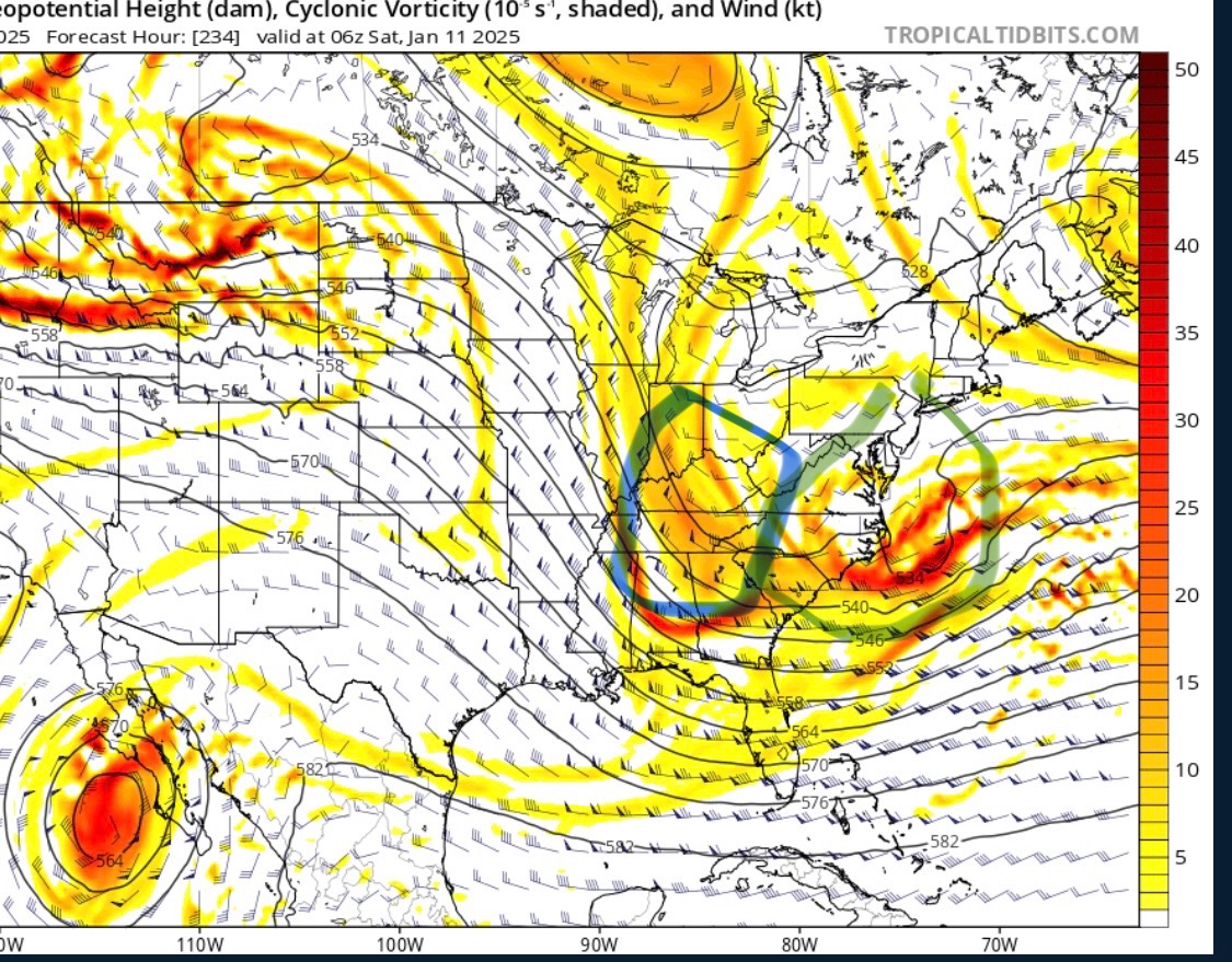
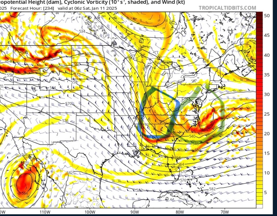
Hard to put any stock in the gfs solution for the 10th given how bouncy it’s been for the 6th, but it’s illustrative for the ingredients of a classic miller A. Here’s the setup at 500mb. Strong southern shortwave (green) and northern shortwave diving in (blue). To turn the coast, we’d want this all shifted west by a couple-few hundred miles. Not a major shift at D10. Then on the next panel, you can see that they don’t quite phase completely. If they did, that would also help pull it north. Still pretty close for d10.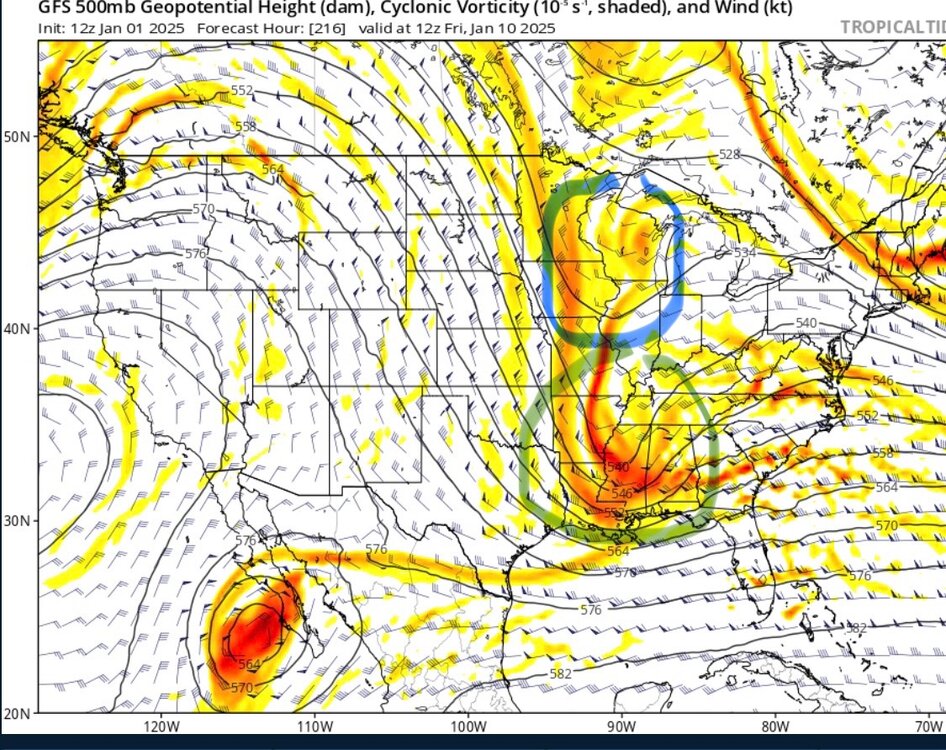
-
January: Medium/ Long Range: May the Force be with Us....
WxUSAF replied to Weather Will's topic in Mid Atlantic
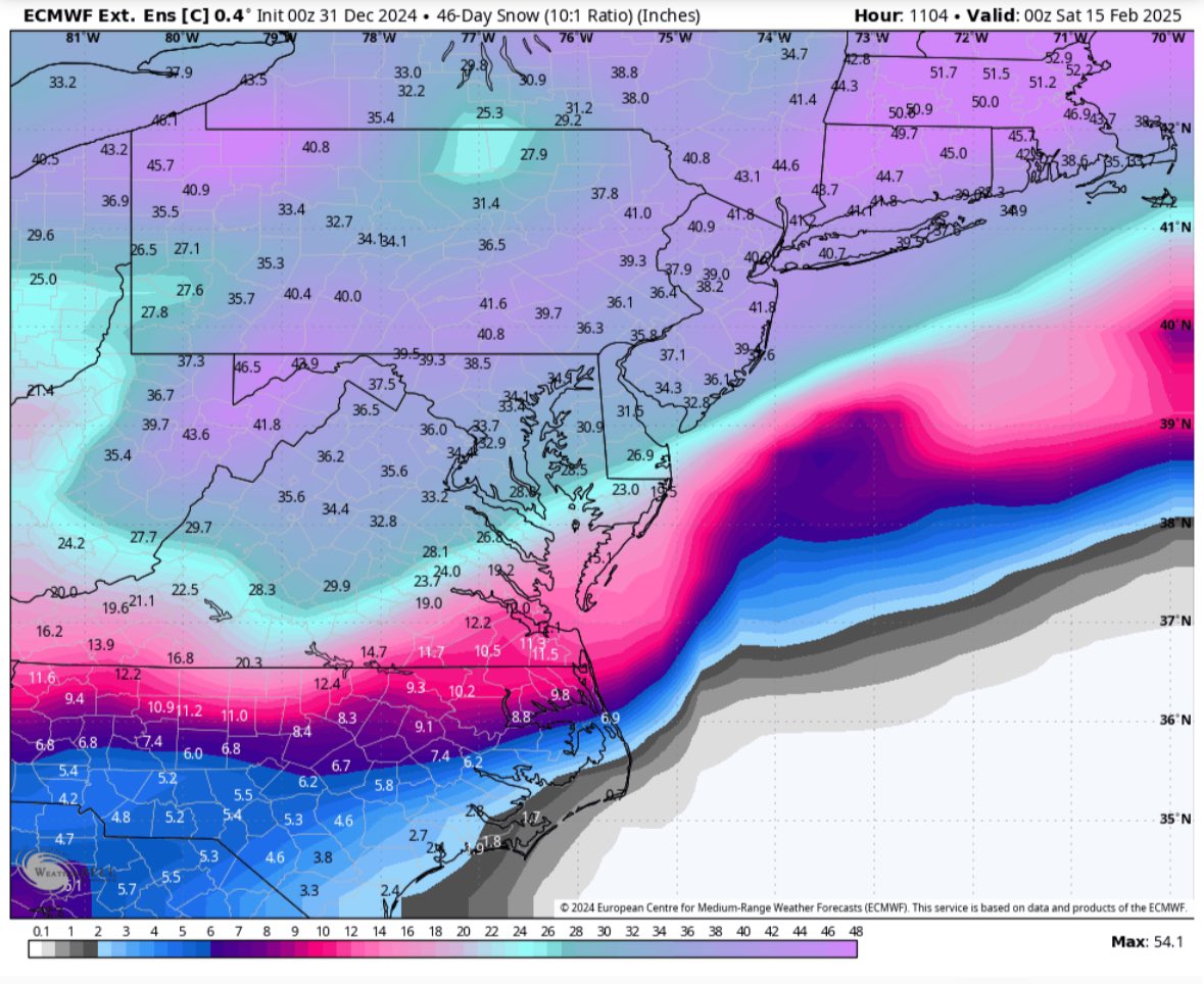
Probably too early to look at this really, but I’m skeptical of ratios much higher than 10:1 in warm sector snowfall. -
BWI exactly normal for December and DCA and IAD fractionally above normal. Warm seems to always win out in the end.
-
January: Medium/ Long Range: May the Force be with Us....
WxUSAF replied to Weather Will's topic in Mid Atlantic
Thanks. Feeling most of the way to 100%. -
January: Medium/ Long Range: May the Force be with Us....
WxUSAF replied to Weather Will's topic in Mid Atlantic
Nice consistency across the guidance with ~120 hours to go. Let’s keep it going. I think by tomorrows 12z runs or definitely 0z Friday, we can feel really good if we have similar looks. -
Happy new year everyone!
-
January: Medium/ Long Range: May the Force be with Us....
WxUSAF replied to Weather Will's topic in Mid Atlantic
GFS with the @CAPE beach blizzard for storm 2 -
January: Medium/ Long Range: May the Force be with Us....
WxUSAF replied to Weather Will's topic in Mid Atlantic
It’s solid. Got to smell the rain to get the goods. Or be on Mt @psuhoffman -
We are!!
-
We Are!!
-
January: Medium/ Long Range: May the Force be with Us....
WxUSAF replied to Weather Will's topic in Mid Atlantic
To get technical as I’m a couple drinks in, this is one more example that the EPS is appropriately dispersive whereas GEFS plays follow the leader at this range. -
January: Medium/ Long Range: May the Force be with Us....
WxUSAF replied to Weather Will's topic in Mid Atlantic
@mitchnick with the NYE weenie rescue -
Best severe wx radar of the year? lol
- 1,696 replies
-
- 3
-

-
- severe
- thunderstorms
- (and 5 more)
-
January: Medium/ Long Range: May the Force be with Us....
WxUSAF replied to Weather Will's topic in Mid Atlantic
We ain’t done after Monday. Not sure what’s going to happen, but we’re not done. -
Large STW south of DC lol
-
January: Medium/ Long Range: May the Force be with Us....
WxUSAF replied to Weather Will's topic in Mid Atlantic
Casual 1000+mi shift inside D5 -
If weekly control snow maps are you thing, have I got one for you (shamelessly stolen from Twitter)

-
January: Medium/ Long Range: May the Force be with Us....
WxUSAF replied to Weather Will's topic in Mid Atlantic
Position of the 50/50 and shortwave spacing are the devily details that won't get sorted out for awhile. And likely what happens with Monday plays a key role in how it sets up for late next week. I remain encouraged that even if late next week doesn't work out, it looks like chances continue beyond. Op Euro buried one of the shortwaves that could give us a storm on the 10-11th, and then brought it up near the end of the run for a weak snow event. Lots of moving parts, but our chances remain well above normal. -
Surface based instability after dark on NYE. What a world.
-
January: Medium/ Long Range: May the Force be with Us....
WxUSAF replied to Weather Will's topic in Mid Atlantic
Max was over DC at 0z and over Fredericksburg now? That’s essentially an identical solution for D6. Caveat that I haven’t looked at anything besides @NorthArlington101’s snowmap. -
I don’t but google translate does