WxUSAF
-
Posts
28,711 -
Joined
-
Last visited
Content Type
Profiles
Blogs
Forums
American Weather
Media Demo
Store
Gallery
Everything posted by WxUSAF
-
Thanks for the catch! Reading comprehension fail.
-
17z NWS map still has me in the jack. Fingers crossed. (stolen from @DarkSharkWX Twitter)
-
That's pretty right on with what my gut says too. I've been telling everyone 4-8", but I'm leaning toward the higher side of that range. 9-10" definitely not out of the question, but 12z runs reversed the nice push we got on 0z. I still don't really trust big ratios on the front end. Evening stuff tomorrow? That's fluff.
-
30/5 with cirrus overcast thickening up
-
Temporarily unpinning
-
Someone make an observations thread. It’s time.
-
@stormtracker you reading the will of the King?
-
Happy New Year’s resolution season at the gym. Oy
-
We’ll do a new thread after euro. You can make it now if you want
-
Pretty large jump north on GGEM. Much closer to GFS, but still a bit south. 0.5” precip line went from well south of DC on 0z to north of a IAD-BWI line.
-
@usedtobe potentially in the jackpot zone on multiple pieces of guidance
-
12z is harshing my 0z buzz
-
Definitely drier. Seems maybe due to weaker shortwave. Confluence is actually backed off notably even vs 6z run. But shortwave can’t pull in as much moisture perhaps.
-
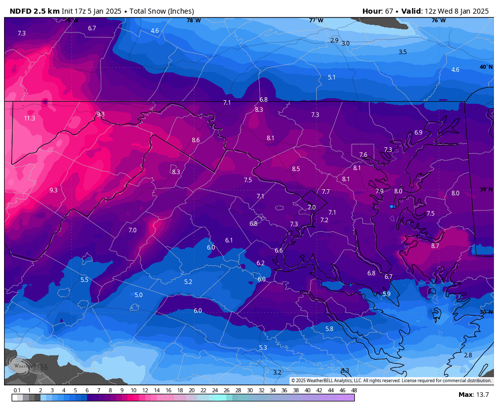
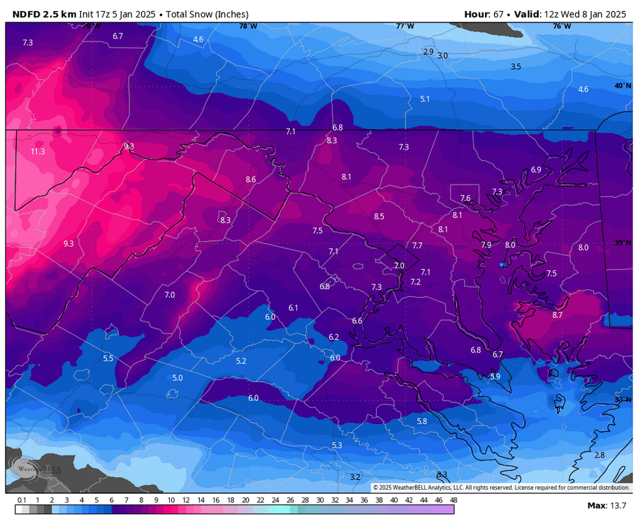
CWG bumped totals to 6-10” for most. 4-8” for M/D line crew and south of Stafford Va to St Mary’s MD.
-
Outside of the DCA tarmac, we’re not going to lose a flake
-
What I've occasionally seen from the GRAF on twitter is that it's closer to the consensus! WBAL seems to want to use a combo of the Ukie and the farther south Euro run from the last 48 hours.
-
This is fairly similar... What the 6z here shows even more though is that areas JUST north of the sleet mixing line are absolutely thumping.

-
DC TV mets all have max snow DC-north. WBAL has been consistent with congrats Short Pump lol. It's weird. I think 3-6" for Harford/Cecil could be reasonable. 2-4"? Gtfo, especially when they have WSWs.
-
Anyone have pretty HREF maps? HREF, not SREF. From what I saw on Twitter (probably old now), it likes DC-Baltimore as the max stripe, but solid for most of us.
-
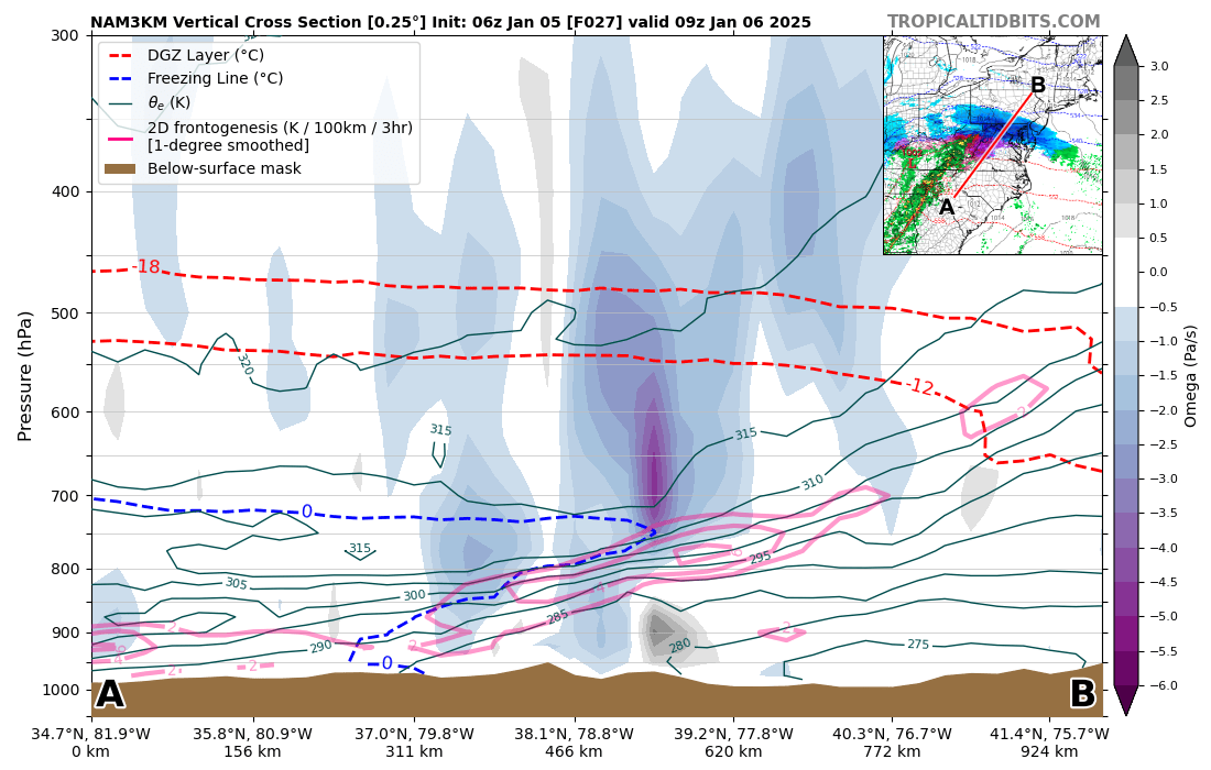
Looked at 6z 3k NAM soundings. DC definitely stays all snow verbatim. Close at 12-13z, but it seems that may partially be due to lighter precip. Column cools again at 14-15z when things get a little heavier. Soundings tomorrow evening are beautiful for 12-15:1 fluff. Plan your @Jebman Jebwalks accordingly.
-
I didn’t think we’d be done after tomorrow and I don’t think we’re done after Saturday. Potential for a major @Bob Chill heater this month.
-
This is one of my favorite Twitter/bsky accounts
-
This has heartbreak written all over it for some of us in the subforum. But a long way to go, so hope I’m wrong. Good thing most of us will score tomorrow.
-
Damn is the euro refreshing to see as a wake up. Assuming no major 12z changes, hard not to just roll with a euro/3k NAM blend. Crazy uncle remains crazy. Euro showing tight gradient on the north side, but mostly in PA/NJ is what we thought would happen and now it’s there on guidance.
-
Ok goodnight weenies. Don’t let the euro f this up while I’m sleeping plz.