WxUSAF
-
Posts
28,803 -
Joined
-
Last visited
Content Type
Profiles
Blogs
Forums
American Weather
Media Demo
Store
Gallery
Everything posted by WxUSAF
-
Ready and waiting. I bet IAD and BWI hit tonight or Monday morning . Maybe RIC too. DCA probably waits until next weekend .
-
Ggem and gfs just casually 17F apart for Saturday morning. Ggem has bwi down to 26, gfs at 43. Last nights euro was 35.
-
You’re tied for the lead!!
-
Looks like it will get chilly after Halloween, but gfs clearly has a major cold bias in the long range. Wait until things get inside D5, and show up in the euro, before getting confident.
-
Those in the know know that RIC usually freezes around BWIs date, not DCAs.
-
Yeah, I've been looking ahead and forgot to pay much attention to this weekend. Maybe IAD too? 3k NAM would suggest so.
-
Unlocking so we can chat about freezes as this gets more plausible
-
3 more hours! Get your entries in!
-
BWI: 11/3 RIC: 11/3 IAD: 10/27 DCA: 11/16 Tie: 10”
-
Bump. A few days left.
-
It’s that time again, despite the fact #endlesssummer2019 is still in full swing. You are forecasting the first day the temperature reaches 32F at BWI, IAD, DCA, and RIC. Tiebreaker is cumulative October precipitation at all 4 of those airports (I.e., one number). This thread will lock when October starts so you have a week! Happy freezing!
-
Bump
-
BWI set a record low max today of 21.
-
Wettest year on record for BWI after yesterday’s storm. Over 63” now with a month and a half left in the year.
-
My hands have been very dry.
-
Maybe it did and I just forgot. But I remember having no issues driving to work.
-
I thought 3/25/13 was ridiculous. I had ~6", nothing on the streets, didn't even get a day off work, and it was all gone by lunch.
-
My WAG is IAD and BWI at least get a fraction of an inch in February and then all 3 airports get 3" of slop overnight in mid-March that melts by 10am. It's like 12-13 but even worse.
-
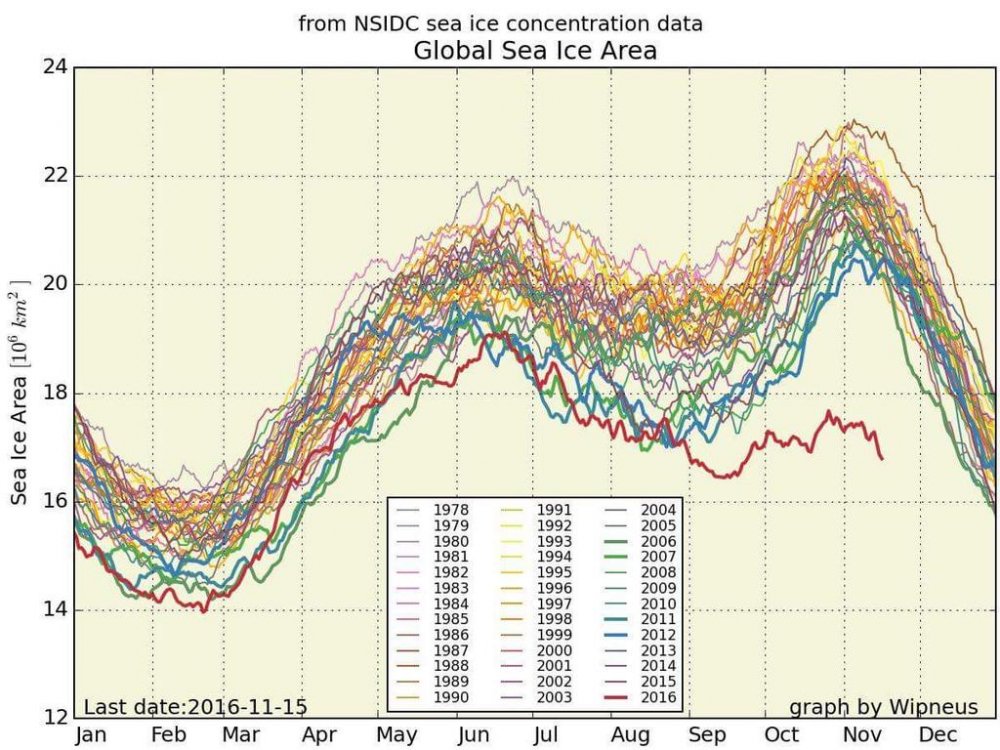
I think that's the idea, yes. So low southern ice and the ridiculously low Arctic ice gives you that insane figure.
-
Ooof. Holy shi-t.
-
Saw on Twitter that the IAD sounding had 1.8" of precipitable water, which sets the all-time Dec-Apr record.
-
What's the most anomalous single day departure on record for the airports? We're looking at a +30 or so for xmas eve?
-
New paper linking the cold winter of 13-14 with the warm central Pacific SST anomaly. http://onlinelibrary.wiley.com/wol1/doi/10.1002/2015GL063083/full
-
10 below normal months at BWI in the period of November 13-February 15. February 15, January 15, November 14, August 14, July 14, April 14, March 14, February 14, January 14, November 13 That's a pretty impressive run given climate and UHI both progressively working against below normal temps. Maybe some of the stat-minded folks can tell us how exceptional it is?
-
1st time with 4 consecutive BN months at BWI since 1970 apparently? According to Tony Pann.