

GrandmasterB
-
Posts
547 -
Joined
-
Last visited
Content Type
Profiles
Blogs
Forums
American Weather
Media Demo
Store
Gallery
Posts posted by GrandmasterB
-
-
37 minutes ago, Blizzard of 93 said:
MDT is now at 2.9 inches of snow for the season through today.
Normally MDT is at 7.4 inches of snow through today, so we have a deficit of 4.5 inches of snow at this moment.
It would only take 1 Advisory level event to get us caught up right now….there is a long way to go yet in this snow season.
Sharp cutoff to the east. LNS is basically at zero. 2 T’s and maybe a .25.
-

Not happening, but us eastern folks can dream!!-
 2
2
-
 1
1
-
-
Would be great to cash in on a little something with system 1 and track crazy solutions for system 2.
-
 3
3
-
-
Pretty much playing out the way we thought after the front. Just some flurries but wind is crazy. Only believe the anafront stuff if there is a weak wave riding along it.
-
4
-
-
1 minute ago, paweather said:
My goodness if this just keeps up all day.
 I'll dream.
I wonder what that next heavy batch on the MD border has in store.
-
1
-
-
Snow/sleet mix. Looks awesome outside. Giving a W to the HRRR. NAM was way too warm here.
-
4 minutes ago, paweather said:
Good deal look forward to before and after snow
Looks like it will be another battle of short range mesos vs. globals. Hopefully mesos win out again!
-
2
-
-
HRRR not backing down. Noted
-
2
-
-
I’d pay for the HRRR to be right. Gets 1” pretty far south and east. We’ll see how accurate that is.
-
2
-
-
56 minutes ago, Ruin said:
Im done with models they are not accurate at all when we need them to be lol. 4-6 days out major snow with cold. but in one model run it goes from costal to lake cutter thats a complete joke

See ya at 12Z!
-
2
-
-
23 minutes ago, Blizzard of 93 said:
The 18z Euro was nice for the front end for the LSV from Harrisburg & York on west.


Thanks for posting! Looks east again. First time it got more than .1 to me.
-
1
-
-
Dang, check out the 18Z RGEM!
-
2
-
-
NAM hits Central pretty hard with the pre frontal thing. Went east a little but beefed up totals quite a bit this run.
-
14 minutes ago, Bubbler86 said:
EC front end. Mostly Western LSV and west in the south moving east a bit as it moves north.

Shifted a bit east again from 0Z. Harrisburg gets measurable this run. The difference between yesterday’s 12Z and today’s is significant.
-
2 minutes ago, anotherman said:
What about on the backend?I didn’t look. The problem with being east of the mountains is you get the downsloping winds after a front. 19/20 times the post frontal stuff is brief and snow showery in nature and doesn’t amount to much even when the models show it run after run.
-
2
-
-
GFS isn’t going to do it this run, but the CMC made a nice southeast shift and beefed up snow totals for the front end stuff Thursday. I know the Euro is hinting at this too.
-
2
-
-
Sleet mixing in now. Trees have a decent amount of ice accumulated, looks wintry!
-
1
-
-
I'm surprised how clear it is here. Is there still time to weenie wishcast a favorable bust? Asking for a friend.
-
1
-
-
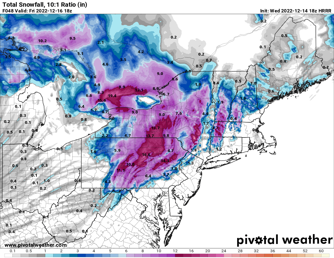
6 minutes ago, Newman said:
18z HRRR. Don't take the 10:1 snow map literally, instead see it as where the line for where predominately frozen precip will fall vs not. The HRRR is MUCH more generous and cooler aloft compared to the NAM. The NAM drives a warm nose aloft into the region while the HRRR is very stubborn to keep it tamed
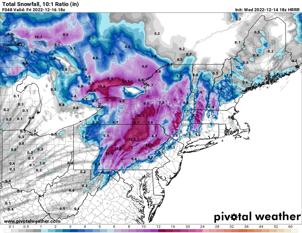
I hate this map
-
NAM blasts rain all the way to NY border. Tough to discount it when we’ve seen warmth win out in these situations.
-
3
-
-
Overall the 12Z GFS looks like another very small improvement, which continues the small improvements since yesterday. The fence sitters are getting closer to the “wintry” side of the fence!
-
12Z GFS at 48 has dewpoints noticeably colder than 6Z. Verbatim it’s low to mid 20’s with precip on the doorstep.
-
1
-
-
13 minutes ago, Mount Joy Snowman said:
The NAM has been consistent in not wanting to give anything accumulating to the southern tier counties.
It did look slightly colder overall and the coastal low a touch further east than 6z NAM. Didn’t do much in practical p-type results for us southern folks, but I still found the slight shift noteworthy.
-
1
-
-
Dang that Euro would work!


Central PA Winter 2022/2023
in Upstate New York/Pennsylvania
Posted
OMG!! This post is insane. Unbelievable work. Almost makes up for the zero snow this year. (Almost)