

GrandmasterB
-
Posts
547 -
Joined
-
Last visited
Content Type
Profiles
Blogs
Forums
American Weather
Media Demo
Store
Gallery
Posts posted by GrandmasterB
-
-
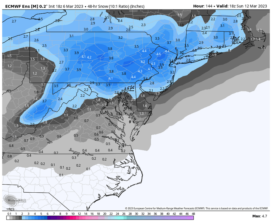
Looks a hair south of 6Z. Southern counties are riding the line. Snowy from central on north.
-
Yeah, I’m good to lock that Euro run! Under 96 hours now too.
-
 1
1
-
-
18Z Euro ensembles look nice
-
1
-
-
One thing for certain, the pattern has potential. Just gotta find a way to cash!
-
2
-
-
2 minutes ago, pasnownut said:
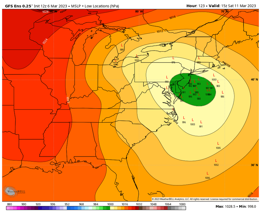
But even if we can get that 100 mile jog S, we'd need to hold it there till Friday as you know it ticks N inside 24.
Furthermore the progressive flow would create a scraper to the E while us westers smoke cirrus and flip the Jersey Birds the bird. Loop the 500's and you'll see what i'm saying. Trough axis keeps it scootin well east for most east coasters.
I think you have great analysis, Nut but I have to disagree on calling this one progressive. Verbatim the GFS has the coastal low looping over and around Long Island for 18+ hours. I wouldn’t label that track progressive, the block is slowing it down it’s just too far north.
-
If this were 75-100 miles further south it would be very very good. Typically not a lot to ask for 100+ out but we all know the drill this year:
-
2
-
 1
1
-
-
7 minutes ago, Bubbler86 said:
ITT2 has no real way to climb later in the GFS run. It really tries after it goes over Florida and sits off the SE coast for several panels. Mixed news for the spring flingers as the suppression is generally caused by a cold dome of high/quite broad trough of the NE corner of the US. The trough is initially positively tilted which is not good for big storm chances of course. By the time it goes neutral it is to our east.
My fear in rooting for ITT2 is that one could be easily squashed by ITT1. The spacing is pretty bad. Based on the season so far, we’ll figure out a way to whiff on both.
-
1
-
-
14 minutes ago, pasnownut said:
Well said bud. We need this well below us...not on top of us.
If that’s a reference to Bud Bundy you win today.
-
This theory hasn’t worked all year, but I’m sticking with “I don’t want to be bullseyed 110 hours out”. In the past, there have been times that the block has forced adjustments in track further south on each subsequent model suite. I’m rolling with that for now!
-
2
-
-
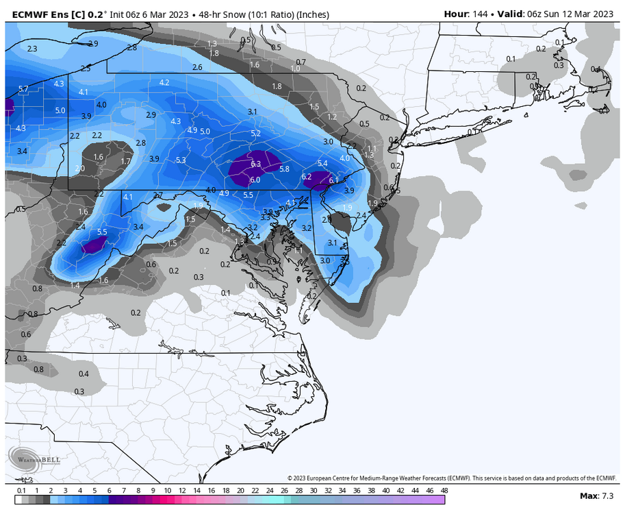
Both the GFS and CMC were further south than their previous runs and pretty close to something decent for C-PA. Still awhile to go.
-
1
-
-
Euro control has to be right one time this winter, right? RIGHT???
-
1
-
-
3 minutes ago, Blizzard of 93 said:
Lol, I give the people what they want!
Most of us on here love the weather in general, but let’s be real…most of us are here to track snow.
That 0z Canadian was too good not to post. The Op models & ensembles are ramping up the potential for next
Let’s ride this one to the end, Blizz!!
-
1
-
-
It’s reassuring to know that if any model spits out 30” in our general area, Blizz will be posting it. That’s world class consistency!
-
1
-
 3
3
-
-
50/50 snow sleet mix. Mulch covered and grass starting to cave. Would love for this to continue until that really heavy stuff out west gets here.
-
Just now, Bubbler86 said:
The hrrr has decent accums not to far from you.
I’m lazy, post maps

-
Fatties mixed in now too. I’m considering this a huge win (for this winter). Don’t even care if it flips to rain the rest of the way.
-
1
-
-
Very surprising considering the globals didn’t really move the rain/snow line too far north throughout the storm. Actually dip it south at the end so will be interesting to see how this happens.
-
Yeah, mostly sleet here with even a little accum starting. Temp has dropped quite a bit with dew point probably close to 32.
-
Now this is more like it!
-
1
-
-
And then Euro is “right where we want it range” for next weekend and still crickets in here. It’s not even March yet weenies, get your heads in the game!
-
1
-
1
-
-
Euro kinda interesting for Monday now. This has shifted quite a bit south over the last 48 hours.
-
Happy hour GFS doing its thing! The clown map is funny because it gives Harrisburg a 6 hour panel of sleet that accumulates 16”.
-
1
-
-
13 minutes ago, Bubbler86 said:
Shit is getting real when the snowbirds like Grandmaster are coming back.
Guilty. Unfortunately “getting real” this season is a Hail Mary, making its own cold air, needs a perfect track, thread the needle, gone tomorrow, 120 hour model fantasy storm.
-
2
-
-
The individual 12Z EPS members are intriguing. Some decent hits in there.
-
1
-
The Ides of March end of Winter 2023
in Upstate New York/Pennsylvania
Posted
That was a painful one. I’d prefer not to repeat it!