

GrandmasterB
-
Posts
547 -
Joined
-
Last visited
Content Type
Profiles
Blogs
Forums
American Weather
Media Demo
Store
Gallery
Posts posted by GrandmasterB
-
-
34 minutes ago, Chris78 said:
I think something else to consider is that snow is an anomaly in our area.
Alot has to go right for us to get snow. As time get close to the actual event models have more/better data and we bleed the wrong way. Also a common model error is height fields being to far south as you go out in time. It's gotten better over the years but it's still a problem
An anomaly where? Doesn’t MDT average like 30”+ a year?
-
 1
1
-
-
Really positive GFS run for those of us riding the line. Shifted some of the minor accumulations about 20 miles south and east of us which gives just a hair breathing room. I also thought it could have been better…when the main slug of precip arrived the GFS was a smidge colder but did something weird with the intensity. Gets the coastal organized more quickly just offshore which would help us with the BL issues.
-
1
-
-
14 minutes ago, mitchnick said:
Well new Cansips has a great January. I just wish MR modeling would cooperate because they're showing nothing but lake cutters.
.thumb.png.9c136427c6912b9b17d3f304b26a511a.png)
MU posted the 10 day Euro and was about as weenie as it gets for the depiction. We’ll see if it translates to actual snow.
-
I hate this hobby
-
 3
3
-
-
MU riding the Euro and calling for a change to rain for us south easterners. Probably reasonable stance at this point unfortunately.
-
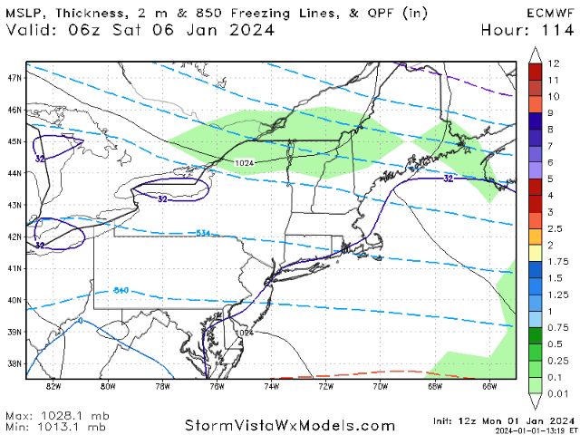
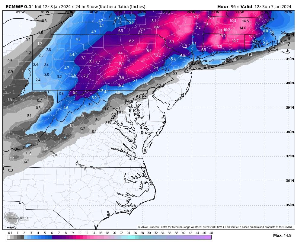
GFS is colder at the surface vs its 12Z run. I like seeing that (obviously). Region wide 6-10.
-
Nice hit on the GFS. I would think that track would keep all of us mostly/all snow especially considering how heavy that precip is modeled on the GFS.
-
1
-
-
-
One thing I’ve noticed on models starting last night was a pretty significant increase in precip intensity along and to the northwest of the R/S line. So while the storm is moving along quickly it seems the intensity could be decent.
-
2 minutes ago, Mount Joy Snowman said:
GFS is in a good spot but is such a swift mover it dampens totals a bit....

Quite a bit more snow than the 6Z
-
1 minute ago, Blizzard of 93 said:
6z EPS looks good for CTP

Not sure the doom and gloom is warranted based on the EPS. I think it’s a little deceiving having the OP end at 90. The heaviest precip wasn’t here yet.
-
Decent band of 6-10 across southeastern areas. State College fringed verbatim, but I think they’d do fine with this evolution.
-
Yeah, that’s a bit of a different evolution per the GFS. I think I prefer this outcome since it would leave a lot of us with some additional wiggle room if it comes more northwest within the last 48 hours.
-
Too close for comfort down here with 4 days left to go. For MBY I’d like to see the stronger primary/less confluence trend reverse tonight or tomorrow or we’re in trouble.
-
Rest up everyone, starting tomorrow we can start to over analyze the NAM!
-
2
-
2
-
-
I’m fine with a region wide 6-12 and then if we get some rainers so be it. It’s been too long to be picky!
-
2
-
-
Southern stream should be plenty juiced too. QPF isn’t well modeled 100+ out, assuming that track we could see some of those higher end amounts. It’s not a slow mover but should be plenty dynamic.
-
High is a touch stronger. Beat down incoming at 132.
-
Looks like it’s going to be a big hit
-
Primary hangs on a bit too long, otherwise it’s damn near classic.
-
1
-
-
-
2 minutes ago, Bubbler86 said:
You have yourself a fan.
LOL, just messing around. It’s a big euro run for all of us and mitchnick has done PBP in the past so I thought it was fitting.
-
1
-
-
Biggest Euro run of mitchnick’s life coming up.
-
GEFS is sick. This was posted a few minutes ago by Millville in MA and I mentioned this yesterday. Get a strong high and even if the inland runner scenario happens we’d still get thumped.
“This was what I wanted to see. A better in-situ signature on the lead will work wonders for the initial precip, as well as maintaining a decent PBL profile during any storm height. There's some serious members too on that high. Saw some 1035mb or so readings when looking at the member plots. Great to see.”
-
1
-
.png.799d331a38648eb129fb9fa01124ecae.png)


Central PA Winter 23/24
in Upstate New York/Pennsylvania
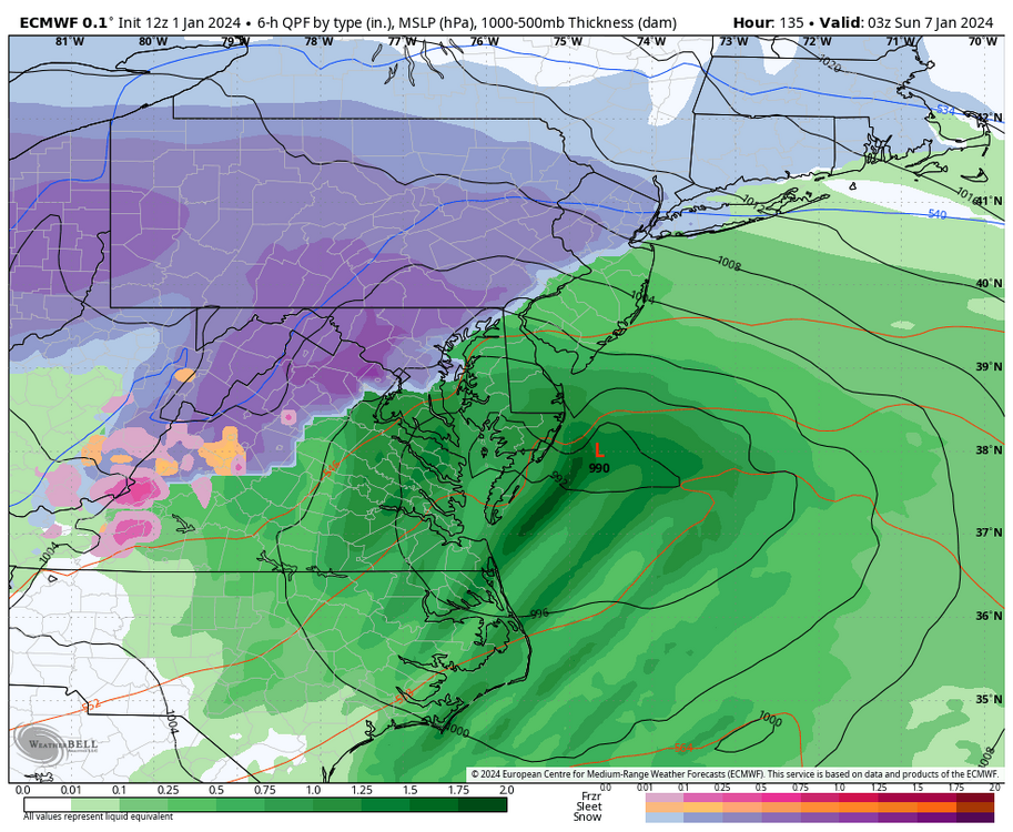
Posted
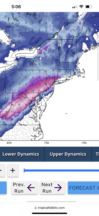
12Z Euro noticeably snowier than 0Z. I don’t have access to 6Z to compare to that run however. R/S line on 12Z struggles to move past Lebanon county this run.