

GrandmasterB
-
Posts
634 -
Joined
-
Last visited
Content Type
Profiles
Blogs
Forums
American Weather
Media Demo
Store
Gallery
Posts posted by GrandmasterB
-
-
14 minutes ago, Bubbler86 said:
EC front end. Mostly Western LSV and west in the south moving east a bit as it moves north.

Shifted a bit east again from 0Z. Harrisburg gets measurable this run. The difference between yesterday’s 12Z and today’s is significant.
-
2 minutes ago, anotherman said:
What about on the backend?I didn’t look. The problem with being east of the mountains is you get the downsloping winds after a front. 19/20 times the post frontal stuff is brief and snow showery in nature and doesn’t amount to much even when the models show it run after run.
-
 2
2
-
-
GFS isn’t going to do it this run, but the CMC made a nice southeast shift and beefed up snow totals for the front end stuff Thursday. I know the Euro is hinting at this too.
-
2
-
-
Sleet mixing in now. Trees have a decent amount of ice accumulated, looks wintry!
-
1
-
-
I'm surprised how clear it is here. Is there still time to weenie wishcast a favorable bust? Asking for a friend.
-
 1
1
-
-
6 minutes ago, Newman said:
18z HRRR. Don't take the 10:1 snow map literally, instead see it as where the line for where predominately frozen precip will fall vs not. The HRRR is MUCH more generous and cooler aloft compared to the NAM. The NAM drives a warm nose aloft into the region while the HRRR is very stubborn to keep it tamed
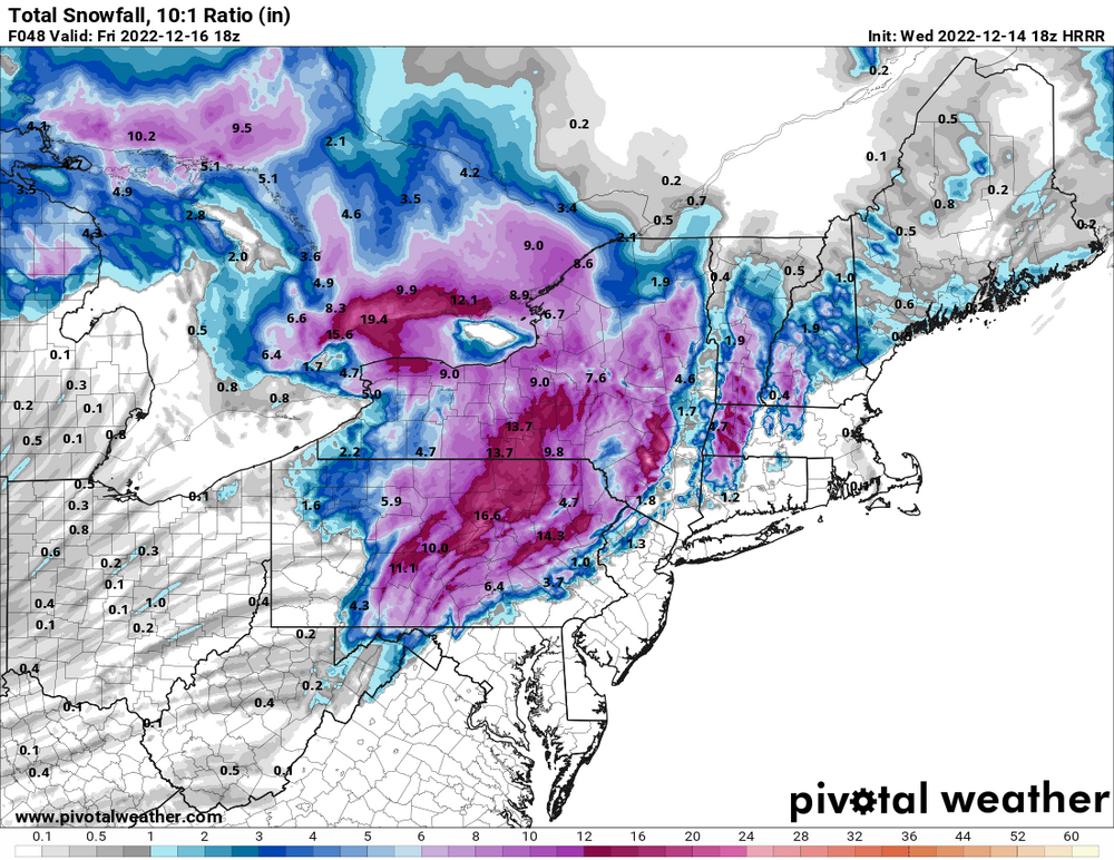
I hate this map
-
NAM blasts rain all the way to NY border. Tough to discount it when we’ve seen warmth win out in these situations.
-
3
-
-
Overall the 12Z GFS looks like another very small improvement, which continues the small improvements since yesterday. The fence sitters are getting closer to the “wintry” side of the fence!
-
12Z GFS at 48 has dewpoints noticeably colder than 6Z. Verbatim it’s low to mid 20’s with precip on the doorstep.
-
1
-
-
13 minutes ago, Mount Joy Snowman said:
The NAM has been consistent in not wanting to give anything accumulating to the southern tier counties.
It did look slightly colder overall and the coastal low a touch further east than 6z NAM. Didn’t do much in practical p-type results for us southern folks, but I still found the slight shift noteworthy.
-
1
-
-
Dang that Euro would work!
-
Certainly, a bump in the right direction on the GFS. Let's see what the other models do. Without any of the blocking I'd be close to punting this one due to the usual nwest trend, but this is a unique set-up. Still lots of time to go.
-
1
-
-
4 minutes ago, paweather said:
NAM Fantasy Land lol

Dews are in the mid 20’s on that panel and upper teens in true central. If that’s accurate it will be tough to scour out.
-
1
-
-
Part of the fun in lurking is observing the chaos of the snow tracking season especially in other forums. I have to admit throughout the years this forum has been rock solid, never too high or low. I appreciate the posters here. Cheers! Here's to a great year of tracking (and hopefully cashing)!!

-
4
-
-
1 hour ago, AtlanticWx said:
18z GFS is a dumpster fire, literally.
I did some research and it looks like Germantown typically has a few feet of pack in place by Dec 15. I advise cancelling winter per this op run.
-
4
-
-
9 minutes ago, Superstorm said:
Temps diving tonight.
.No kidding. I've weenie wishcasted my temp down to 33 already.
-
21 minutes ago, Bubbler86 said:
Can I take my 4-6 to the bank?
Don't bank it until it's falling from the sky!

-
1
-
-
Wow at that GFS run. Dang! Good thump for the true central folks.
-
17 minutes ago, paweather said:
Pretty darn close:
Storm started out a little further SE on the NAM but surface a little warmer so it washed. Looks like we'll end with close but no cigar in the southeast but north and west of Harrisburg continues to look good for some light accums.
-
1
-
-
That's quite a shift on the Euro. Kinda the only model at this point that gets rain/snow mix that far south and it's a large shift from the 0Z run so tough to put a lot of stock in it. Will probably go back closer to the 0Z run at 18Z. I'll still enjoy the digital white rain for 6 more hours.
-
1
-
-
19 minutes ago, paweather said:
I’m excited!!!
Are you in Hershey? I'm not getting my hopes up for more than some rain/snow mix to start. We still need a lot of help. Further northwest I think could see some accumulation.
-
High stronger and in a better position on all 12Z guidance. A few more ticks that way and maybe even the SE portion (what I care about) gets on the board. I'd certainly be excited if I were in State College.
-
2
-
-
GFS is colder but storm is kind of a mess that lacks significant precip.
-
84 hour NAM map has been posted. I believe that's the official start of the season!
-
2
-

Central PA Winter 2022/2023
in Upstate New York/Pennsylvania
Posted
NAM hits Central pretty hard with the pre frontal thing. Went east a little but beefed up totals quite a bit this run.