

Jackstraw
-
Posts
2,268 -
Joined
-
Last visited
Content Type
Profiles
Blogs
Forums
American Weather
Media Demo
Store
Gallery
Posts posted by Jackstraw
-
-
KIWX going with 6-10 inches Wed and Wed night 2 miles to my north. KIND not biting on snowfall amounts 2 miles to my south. Thats life on the edge lol.
KIWX
WednesdayRain before 9am, then snow. High near 35. Northeast wind 10 to 15 mph. Chance of precipitation is 100%. New snow accumulation of 3 to 5 inches possible.Wednesday NightSnow. Low around 21. Chance of precipitation is 100%. New snow accumulation of 3 to 5 inches possible.KIND
WednesdaySnow, possibly mixed with rain, becoming all snow after 2pm. High near 36. Northeast wind 7 to 11 mph. Chance of precipitation is 100%. New precipitation amounts between three quarters and one inch possible.Wednesday NightSnow, possibly mixed with freezing rain, becoming all snow after 8pm. Low around 22. Chance of precipitation is 100%. New precipitation amounts between a half and three quarters of an inch possible.KIND for Kokomowx 15 miles to the NWWednesdayFreezing rain, possibly mixed with snow, becoming all snow after 7am. The snow could be heavy at times. High near 33. North northeast wind around 11 mph, with gusts as high as 18 mph. Chance of precipitation is 100%. New precipitation amounts between three quarters and one inch possible.Wednesday NightSnow. Low around 21. Chance of precipitation is 100%.-
 1
1
-
-
5 minutes ago, Chicago WX said:
We shall see. I’m not buying the trumped up Kuchera totals at all. 10:1 is a good ballpark considering what ratios will start as (low) and end with (little higher). It’s all overrunning for us as the main storm will largely whiff south. And like I said, we will waste some precip on rain. Changeover time will be crucial. But I’ve wrong a million times before…
Agreed. Not buying those 25-30 in totals either. Think this 12Z Euro run makes more sense, with the usual 10-15% or so reduction, from a storm(s) total standpoint. And of course because it keeps the FZ- pinger party away from me

-
2 hours ago, Powerball said:
What/who do we have to sacrifice in order to get the 1/29 12z GFS run back?
Probably me lol. Per usual a 25 mile shift is the difference of warning criteria snow or hellish cold rain, FZ and pingertown misery.
-
2
-
-
lmao

-
 1
1
-
-
1 minute ago, Chicago WX said:
cyclone going to reel in another big dog. And Hawkeye is starting to get interested.
IM SURE GLAD NOTHINGS CHANGED AROUND HERE!!!!! lmao
-
1
-
-
2 hours ago, IWXwx said:
FYP. Truthfully, I'm afraid of the fact that even a 50 mile north shift would put us in danger of ice. We may begin with overrunning rain the way it is. It pains me to say it, but I'd rather have sleet than ice (The former LAF guys know what i mean).
Hail, Hail, the gang's all here. Good to see @snowstormcanuck, @Chicago WX, @TheWeatherPimp, @Harry, and I guess that you can throw @Thundersnow12in there. Welcome back. A lot of us old farts are still around.
lol

-
5
-
-
Why are people posting GFS clown maps at 240 hours? (sarcasm)
-
2
-
-
Hey all, been awhile, thought Id jump back into the fray as winter here has s####d so far. Except for the nickle dime half inch at a time 2 inch weenie pack from last weeks paltry clipperfest thats the only measurable snow so far. Plus the fact i got skunked with GHD I and semi skunked (comparatively) with GHD II I'm putting the Pagan Hexy Hex on the Chitowners for this 'possible' GHD III storm. Y'all have had yours so far. Hoping it buries the I-70 north crew from IL to OH for once. Been riding the Euro wagon with this one, think the GFS is too slow with the arctic death cold thats coming. Besides Im jonesing to get the dogs in the truck and go drift busting.
Probably just jinxed it lol
-
 8
8
-
-
Thank goodness there is no wind. I've never seen the tops of these leaves lol
![20210421_011158[1].jpg](https://www.americanwx.com/bb/uploads/monthly_2021_04/1799380446_20210421_0111581.thumb.jpg.1ba1b729f05ce85c78c9c6cb0b75af50.jpg)
-
4
-
-
I've been in Fl for the last 6 weeks tending to family matters. Weather wasnt much on my mind. Imagine my surprise when the plane was landing at 6pm to some snow, not flurries, full on snow! Wow. Wife told me on the phone it was just starting to snow when I was boarding, she got me home around 8 and just wow again. We took a ride around 11 and the country roads were well covered and slick. Snow stopped here about 12-12:30. Stuck a ruler in a planter on the back deck it said 4 inches FWIW. Maple tree limbs that are normally 15 ft above my back deck are literally 2 feet above it. This is some crazy shitz lol.
-
4
-
-
^Why did you send it this way? We were supposed to be 0, it's freakin -9. Y'all can keep that stuff, just send me more of your snow

-
We gonna name this one? Since the EC has their "Presidents Day" and now that Presidents Day is officially Washingtons Birthday (leave it alone) I suggest "The WB"

-
Just now, cyclone77 said:
Still snowing here, got about 2". Ratios seem quite low due to the sugary nature from the pixies, but makes for a quality addition to the existing snowpack. About 18-19" of snow and ice on the ground now.
Well, I said it was winding down here. Just started +SN fat flakes from a desperate weenie band moving in. This thing just won't stop, not that I'm complaining lol.
-
1
-
-
Finally winding down here, I think lol. Been snowing consistently since about 2 pm not counting wave one. Always been steady SN to +SN with wide types of dendrites. Roads out here are trash, some with 4 to 6 ft drifts. Walked out to my road with the dogs around 9 and there were a couple drifts that came up to my chest and I'm 6'2". So we're stuck for awhile. Weather station recorded sustained 25KT winds for more than an hour a couple times, once when that first fgen band came through around 2-3, and the 2nd from about 6- 8:30 or so. Highest gust was 38KT's at 7:55. Plenty of gusts over 30KT's throughout. About the craziest and most fun snow event since I moved here, maybe because we just don't see a system like that around here very often.
-
2
-
-
Just now, michsnowfreak said:
blizzard conditions outside. stormy, blowing, drifting. Will be fun to wake up in the morning.
Will be fun when it stops so I can sleep lol
-
2
-
1
-
-
Have to be approaching a foot here. Its been rip city for the last 90 minutes, non-stop nice dendrites. This thing wont quit.
-
1
-
-
4 minutes ago, cyclone77 said:
Pretty cool looking system on the ol' sat
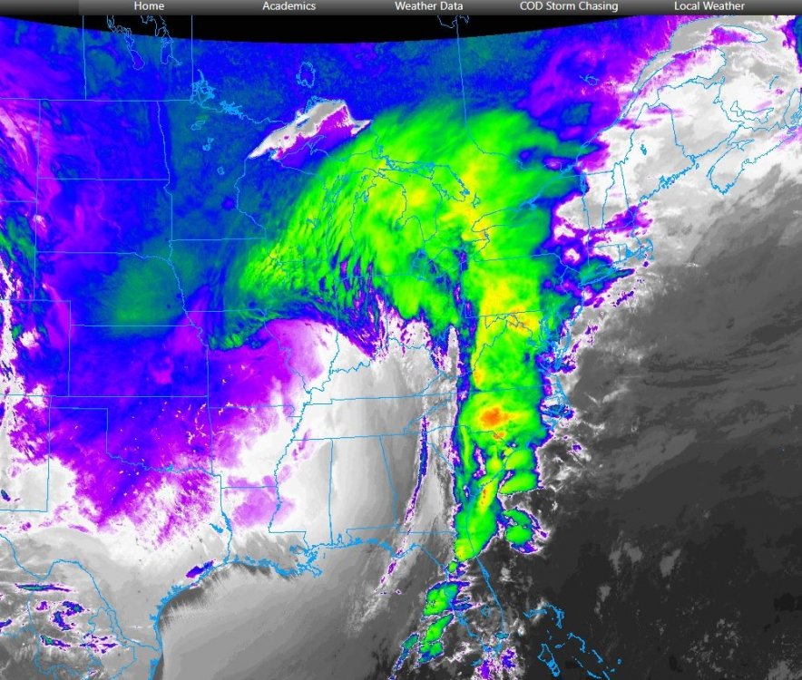
Crackin' the whip
-
Per meso we've been in the best alignment with the surface low, 850 and 700 for the past couple hours or so. Should continue for the maybe the next 2 hours from returns. Still recovering from the last venture in the truck, crazy s$%t out there lol.
-
1
-
-
18 minutes ago, Chambana said:
Heavy band incoming. Shits the real deal boys, this storm is so fun. Grabbing my AirPods and walking again.
Giddy doesn’t begin to explain my excitement. I’m on a high right now.
Lol, havent left my driveway, beginning to debate my decision to take one more ride lol.
-
2 minutes ago, ILSNOW said:
21z RAP still bringing the goods with an additional 14 inches for eastern lake and northern cook county
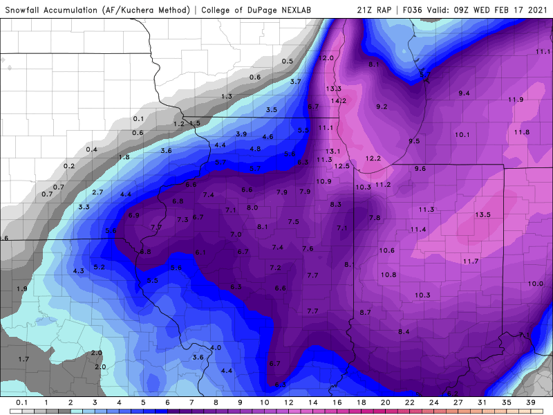
If the RAP verifies it's giving me another 11 that will put me at 16-17 in 24 hours. Those are 77-78 numbers for us.
-
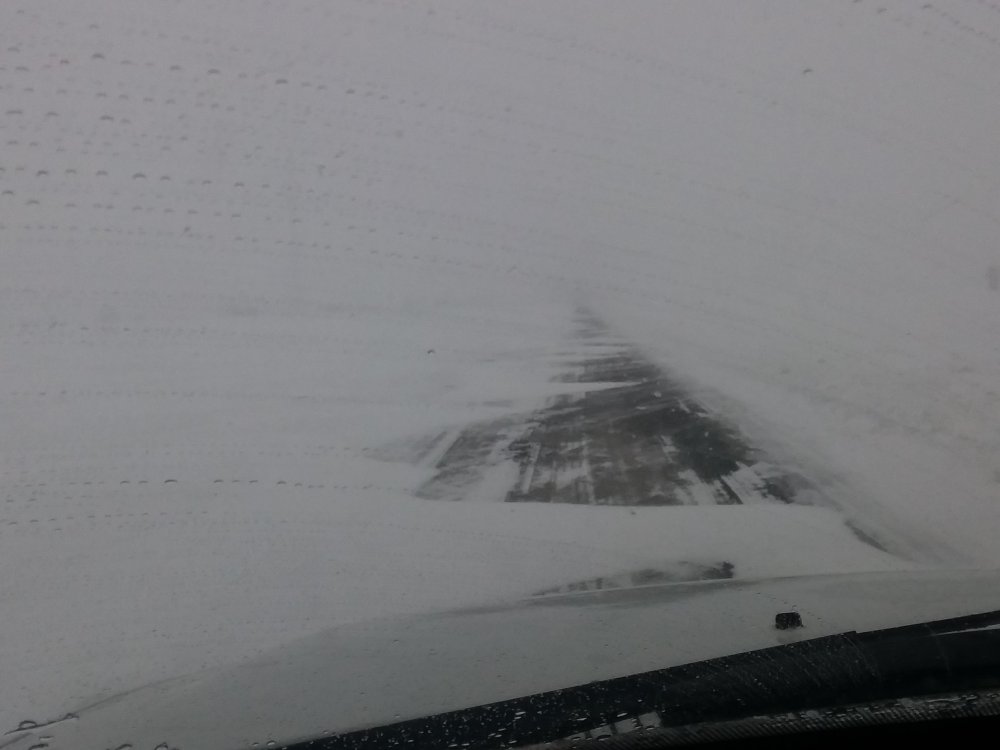
Quick report from the stix, it's been getting real the last 2 hours. The wind is a lot stronger than forecast, seeing 20KT sustained gusts to 30KT out here. The onset was a couple hours early with that little 700mb perturbation spinning up. Snow wasn;t that heavy when that initial band started moving through around 2 but the wind really started the blow fest and keeping flake size in check. Rates really picked up around 3:30. Visibilities got down to 1/4 mile to nearly 0 at times. I'm guessing another 2 to 3 since 3pm, impossible to measure out here. There's plenty of 3 foot drifts to choose from lol. It was starting to get pretty bad in town about an hour ago, even some decent drifting starting there. Highways are covered slick and shaky, the secondary roads are between being fun and scary. If we can avoid any surprise dry slots (theyre always lurking lol) the brunts do to start here through the next 3-5 hours we could approach 10, maybe even a foot. It's still ripping out there and again, that damn wind. Heading back out one more time, don't think it'll be safe in an hour or two. Quick pic from around an hour ago or so. I'm in weenie wonderland lmao
-
7
-
 2
2
-
-
Looks like about 7-11 tonight is going to be happy hours around here. Bring it...

-
35 minutes ago, TiptonMike said:
N/S roads in Tipton and points south to NE Side were passable at 7am this morning. I can't imagine that lasting through the rush hour though.
A poster just down the road, welcome. We need some more central IN posters. Think the E/W roads are going to be the worst, especially if we get into some 30mph gusts tonight and tomorrow like they're talking. Actually saw a Tipton county plow out already plowing their side of county line road. Jokers on this side are slackers lol. Keep us up to date on how storm go's for you over there.
-
1
-
-
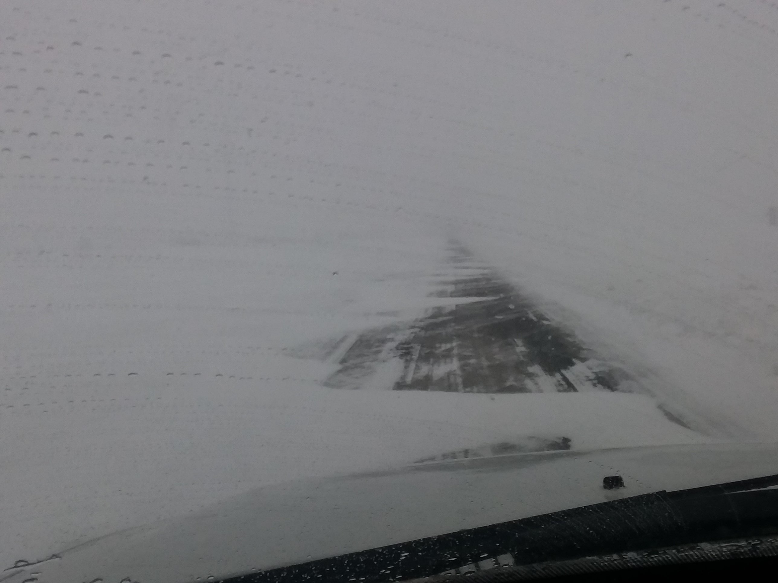
Got about 2.5 to 3 this morning. The big drift has begun. My roads already down to one lane. Gonna go out and play before the main course starts in few hours. Friend just north of Houston said its insane down there lol.
![20210421_011158[1].jpg](https://www.americanwx.com/bb/uploads/monthly_2021_04/1120836485_20210421_0111581.jpg.4eb2f9cb6f77b789022bd998a4fa9939.jpg)

Feb 1-3rd GHD III Part 2
in Lakes/Ohio Valley
Posted
You must be riding the RAP lol