

Jackstraw
-
Posts
2,268 -
Joined
-
Last visited
Content Type
Profiles
Blogs
Forums
American Weather
Media Demo
Store
Gallery
Posts posted by Jackstraw
-
-
Just now, IWXwx said:
Have already had multiple upper 50 gusts here, and it looks to continue, maybe even topping 60 in next few hours. I haven't checked my CoCoRaHS gauge, screw that, it's too nasty out there, but guessing that we are pushing an inch and half of rain with at least another half to 3/4s incoming.
Yeah I went out around noon to look and it was worse than a 50mph blizzard lol. I'm guessing 2.5 in my guage, Im not going back out unless it warms up. KIND is saying winds should increase until about 10pm now. 58 highest gust here so far 980mb pressure. I want 979 dambit! lol
-
 2
2
-
-
6 minutes ago, Chicago Storm said:

.Its 981 here. We just might make it into the 970's. Lowest non official I've recorded 978 here once on my old station in 10 years.
-
1
-
-
4 minutes ago, StormChaser4Life said:
Nice gravity waves showing up
Was looking at those. The dynamics of this system have been impressive all day. Like you said some cold air or even heat up the warm sector this coulda been a humdinger.
-
1
-
-
Just had a non storm gust of 56mph. I wanna play too, its all I got

-
 2
2
-
-
6 minutes ago, Lightning said:
Fun has finally begun here. Sometimes it is hard to be one of the most northern posters (Outflow I know is even further north of me).
C'mon down here with us Interstate Kitchen Sink er 70 posters, we'll toughen you up lol.
")
-
3
-
-
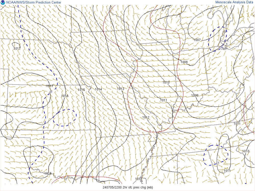
Pressures are 977mb in SW IN and some pressure falls of 5mb's in 2 hours. Thats some serious Mack Daddy shit for around here...
-
1
-
3
-
 1
1
-
-
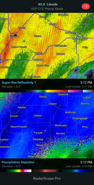
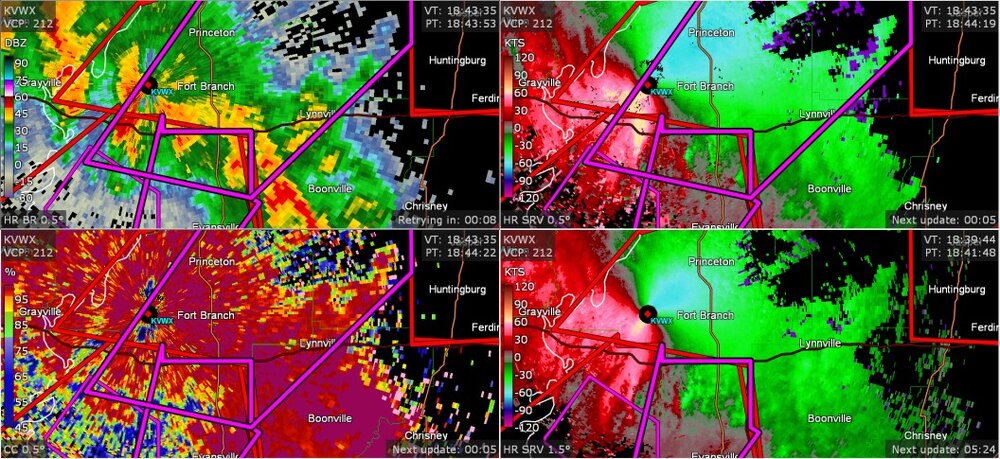
3 minutes ago, Chinook said:
well, this is in the Ohio Valley area... apparently this was a confirmed tornado, and a few more warnings in the Evansville region
Yeah, in a way we're lucky. This system is just thermodynamically short of possibly being one of those March outbreaks for the history books.
-
Well it's not snow but it is freakin knarley as hell out. 36F 2.25 in of sideways rain so far wind 25-30 gusts to 45 for the last 4 hours. With a 988mb pressure and falling it has seriously felt like a tropical storm for the last 4 hours outside with big drops slamming the windows in the howling wind except the wind chill is 29 lol.
Ima gonna go looking for that flying pizza

-
1
-
3
-
-
5.5 inches final call here.
BTW I'm really high, I just saw a flying pizza.
Goodbye cruel winter

-
3
-
-
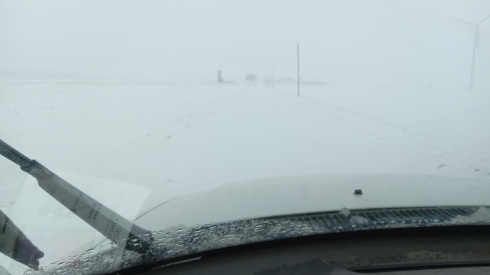
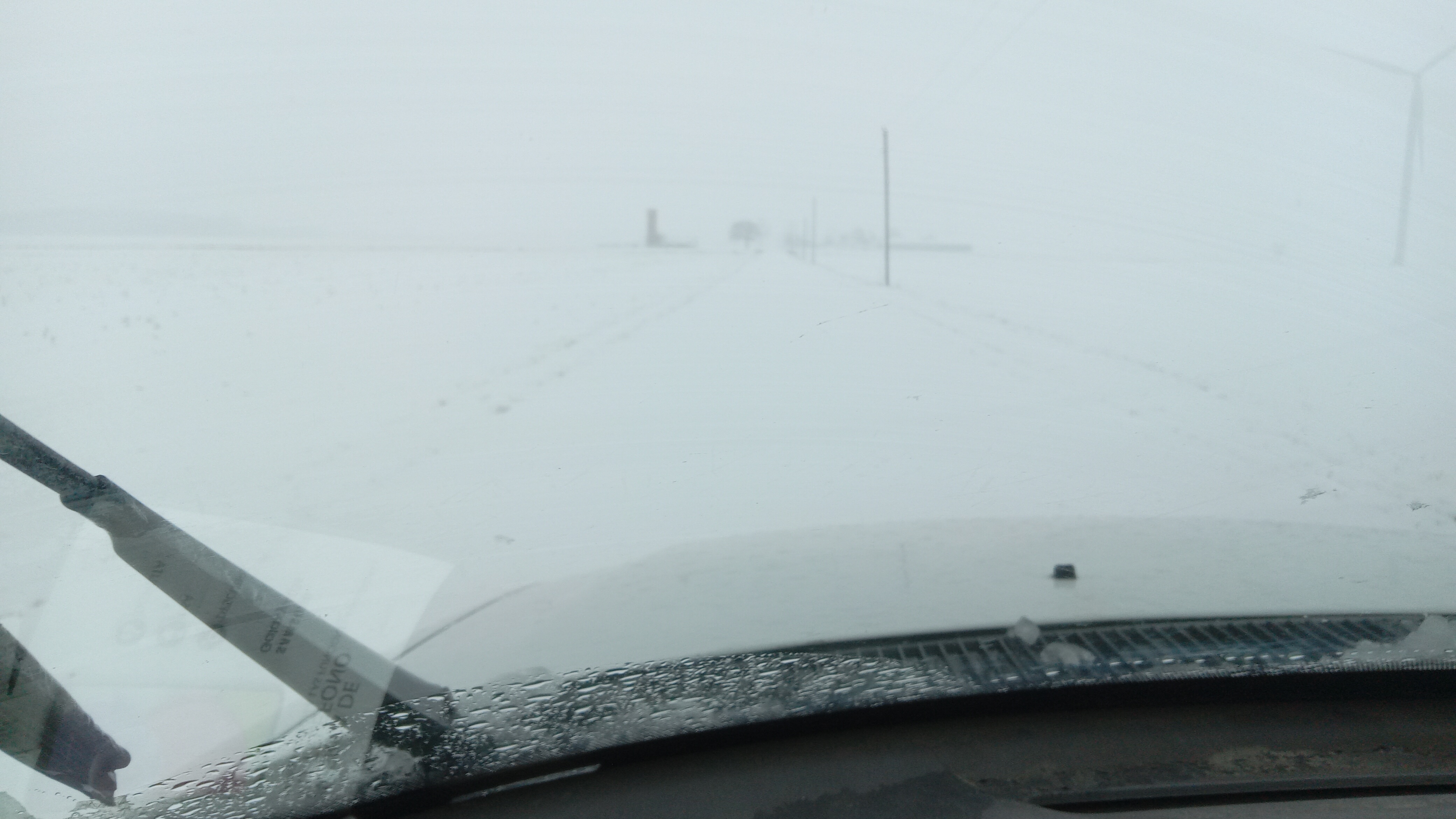
Where's the road? Lol
-
3
-
-
Blasting giant flakes. Heading back out to play while the defo sits on my face lol
-
1
-
3
-
-
And so it begins, parachutes sighted. Deck covered in about 10 min. This is a bit of a rare system for us if the heavy snow rates being forecast pan out later this morning. We usually need these systems to come through at night (unless we're in early Feb arctic mode) or we lose a lot to liquid. We dont get to see sustained 1-2in/hr rates in the daytime around here very often. Looking forward to it hopefully. Good luck to all

-
1
-
-

 Mesoscale Discussion 0102
   NWS Storm Prediction Center Norman OK
   1144 PM CST Tue Jan 24 2023

   Areas affected...southern portions of IL...IN...and OH

   Concerning...Heavy snow

   Valid 250544Z - 251145Z

   SUMMARY...Broad precipitation will continue to overspread the region
   from around 06-12z. Localized heavy snowfall rates greater than
   1"/hr will be possible.

   DISCUSSION...The low-level precipitation field continues to expand
   in advance of a negatively tilted upper-level trough ejecting over
   the central CONUS. Snowfall rates of 1"/hr have been reported from
   eastern OK northeastward through southeastern MO, and in some areas
   localized snowfall rates around 2"/hr have been observed. The broad
   precipitation band responsible for these snowfall rates continues to
   translate northeastward in tandem with 700-mb frontogenesis and
   mesoscale isentropic ascent. These features are expected to persist
   for the next several hours and produce 1"/hr snowfall rates through
   12z, generally advancing from west to east across the outlined area.
   Snowfall rates of 2"/hr or greater will be possible in localized
   areas where enhanced forcing overlaps non-zero potential buoyancy
   (10-20 J/kg MUCAPE) in the dendritic growth zone.

   ..Flournoy/Moore.. 01/25/2023

   ...Please see www.spc.noaa.gov for graphic product...

   ATTN...WFO...PBZ...RLX...CLE...ILN...LMK...IWX...IND...PAH...
   ILX...LSX...
-
 1
1
-
-
1 hour ago, bowtie` said:
Already seeing some color on the county travel hazards map for Indiana. Allen county ( Ft. Wayne) and Hamilton county (northside of Indianapolis), are already under a travel watch. I guess some EMS managers are being proactive seeing how the snow has not even started yet.
I've been out driving and walking a limping dog the last few hours (I live in the sticks) and its probably for black ice. The weekend stuff finished melting this afternoon but its been extremely damp out there all day and evening. We had maybe 2 hours of sun today, not near enough to dry secondary roads completely especially with the dews we had today. I can attest that about an hour ago there was suddenly an invisible glaze on the road as I slid right through a stop sign. About busted my ass a few times walking. Its like an eggshell thin layer and its patchy and kinda scares you to be honest lol.
-
1
-
-
2 hours ago, IWXwx said:
Thanks for giving me confidence in my call.
And in my call for 6 too.
Still ain't shovelin' it
-
20 hours ago, Hoosier said:
Now post the snow depth map from pivotal.

A little cream in the cup of mud?

-
1
-
-
23 minutes ago, bowtie` said:
The latest accumulation map from IND and their winter storm briefing has me (Boone county) at 8' to 12" and LAF at 6" to 8".
"They've been advertising the highest amounts just north and west of Indy for a couple days. Think thats where they expect the least issues with liquid and if/any trowal type banding to establish. I'm 40 miles NE of you and that map has a similar cutoff 20 miles to my SE. I'd take it with a grain of rock salt.
-
3 hours ago, KokomoWX said:
12z HRRR (48 hours)
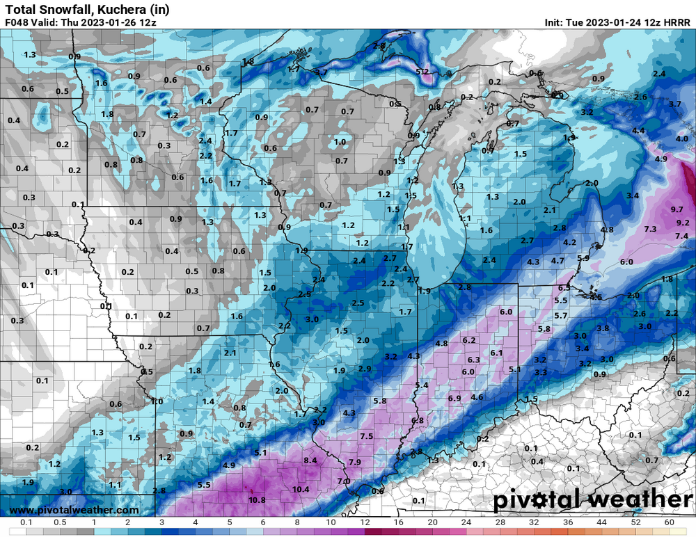
I'd go with the 10-1 pile of concrete. They're also looking better for an upper level backend kick in the pants over us where rates could keep the liquid at bay. Fingers crossed lol

-
1
-
-
Shit like this causes mental illness around here lol.

-
 1
1
-
-
While not as nerve racking as usual...Yet.... for the Kitchen Sink zone in N Central IN, some of the 12Z model soundings are enough to keep the foot shaking. If rates can stay heavy early Wed. should be ok but the yellow brick road doesn't lead to these parts lol. Regardless this things gonna be a cement truck laying sidewalk as it comes through. KIND is saying 5-9" for here and KIWX is calling 7-12" 2 miles away.
I'll call 6 and my back ain't shoveling any of it

-
2
-
-
I got nuthin' to complain about with these runs so far........ Yet
-
7 hours ago, IWXwx said:
Call it intuition, but I think we'll score in this area (North Central/Northeast IN) even if it comes as multiple minor events over the next 10 days or so. Anyone down toward I 70 might as well post the Eurythmics.
-
3
-
-
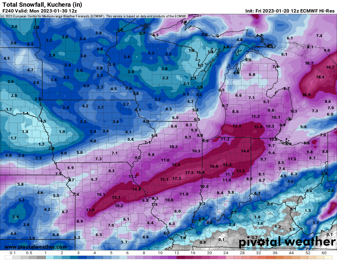
27 minutes ago, KokomoWX said:
12z Euro coming in hot for a parade of storms.

You and me both know unless this maps 12 hours out its gonna be a kitchen sink Lucy pulls the football event for us lol. It is pretty to look at though
-
1
-
-
23 minutes ago, Hoosier said:
The lake enhanced stuff that we get on the backside may be a top 5 event locally this winter.
That 200 mile long lake enhanced streamer off of lake Michigan is flabbergasting lol
-
1
-


Winter 2022/23 Medium/Long Range Discussion
in Lakes/Ohio Valley
Posted
I thought JB was full of it 25 years ago and I still believe he is majorly responsible for the sensationalist BS mass produced "science" of forecasting for public consumption of the last couple of decades. It's my opinion of course but I think he did a lot of damage to the real science some of which we have yet to recover.
March has delivered the 2 biggest double digit snows in my area the last decade so Im not completely done yet lol