

Jackstraw
-
Posts
2,383 -
Joined
-
Last visited
Content Type
Profiles
Blogs
Forums
American Weather
Media Demo
Store
Gallery
Posts posted by Jackstraw
-
-
It will be really nice to get a perfectly timed pop up storm in this pattern to give a quick cool down and have one enjoyable (moderately anyway) evening. This 80 degrees at midnight crap is still giving me flashbacks. Anything after 6. Anything earlier would suck. They need to come out for localized advisory's for early-mid afternoon showers in this setup. Something like an Emergency Sauna Advisory lol.
-
 1
1
-
-
Well the tree and power line trucks are gone. I swear you'd have thought we got hit by a hurricane by as many of them that were all over this area until yesterday. Took a drive over the weekend and it was pretty bad for the trees, big trees, I mean 2-3 footers, 6in-1ft limbs down everywhere. From my previous hurricane life conditions were similar to a slow approaching hurricane as the specific area around me was hammered with up to a half foot of rain so we were already flooding when that line hit. That meant the trees and the ground were pre-soaked and primed to fall if there were strong enough winds and there were. Easily close to 1 min sustained strong TS force with Cat 1, maybe Cat 2 gusts through that area. Eerily similar to how widespread tree damage is caused along the coast in strong TS's/weak Hurricanes only without a storm surge.
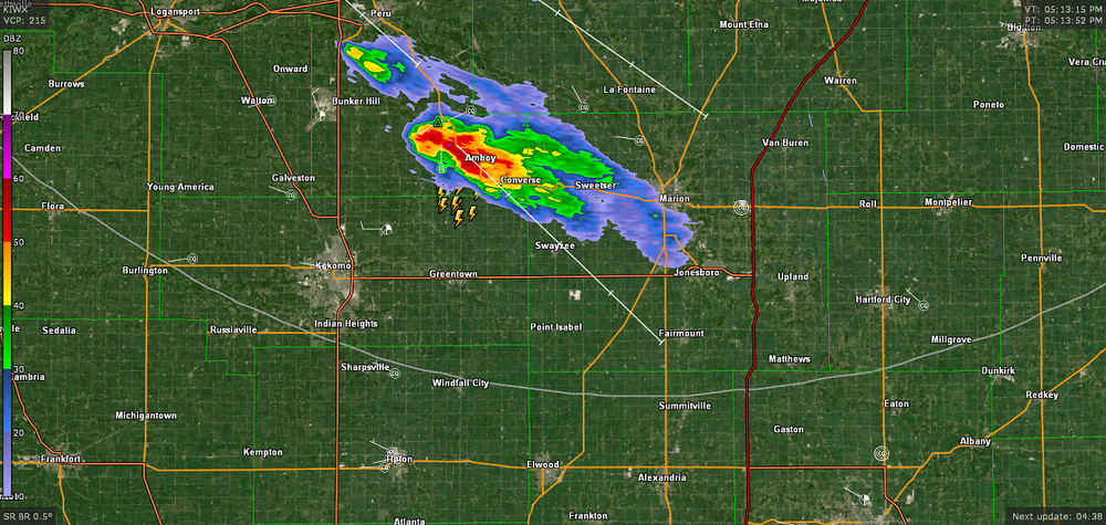
Been awhile since I've seen that much widespread tree damage around here, especially central Madison over into Delaware and Blackford counties. Along with the gusting "almost a D word" line there was also a significant downburst, IMO, through that area as a pre-frontal cell that blew up ahead of that line was consumed within it. You can see it in these 2 radar images from KIND's event page. The first Image, its in front of the main line as it was blowing up just SW of Marion and the second, you can almost see the exact shape of it embedded within the line just ENE of its previous position almost directly S of Marion. What was even more interesting, to me anyway, was a very small ragged "donut hole" type feature immediately behind it. That "donut hole" artifact or whatever it was passed right over my position where I nearly hit a tree as it came down. I don't think its radar shadowing or anything like you would see during a hurricane. I really think, IMO, its a radar image of a downburst or microburst (are there Sting Jets in severe lines?lol) from or enhanced by that rapidly forming small SUP out ahead, possibly from it collapsing within the line accelerating the forward "gust front" even more. I mean that thing shot up to 55kft in like 20min on Radarscope before the "Meg" line ate it lol. That's why I was chasing it. It had a rapidly lowering wall cloud, a good hail core (2-2.5 inchers reported directly under its position in the Alexandria, Summitville areas) and was just forming a nice tail/hook on radar (you can see that a bit in the first image). Back flow was ramping up into that little SUPs gut as the updraft accelerated. Went from maybe 15 to 20KTs, more parallel flow from the SSW, then suddenly veered to easily 30-35KTs from the SSE as I got about 2 miles S of it.
I'm more than likely over analyzing it lol. It more likely the ton of very localized rain that resulted in so many large trees and limbs concentrated in that area as opposed to more spread out in other areas. I counted at least 65 entire trees larger than 2 feet either uprooted or snapped just on my 2 hour drive. North and south, where they didn't get massively presoaked there was not nearly as much concentrated tree damage though. But those radar images kind of puzzled me when KIND put them out Sunday triggering the ADHD non scientist in me

One of the stranger storm chases I've done. Wasn't prepared, very chaotic spur of the moment chase looking out the windows, at the radar on the phone at 45 to 50mph on country roads (around Moonville IN, the worst place to chase lol), in and out of densely wooded areas along White River and suddenly dodging falling trees and sideways rain all at the same time lol.
Whatever, sorry for the long post, I'm just out of heat therapy but it was nutz lol.

(Don't get on me about safety, y'all have done it before lmao)
-
5
-
-
95/75 nearly every day for 5 months is SE US living at it's finest lol. Then break out the giant tiger mosquitos that can drain a pint per bite. The old saying in South Calalacky if you ain't on the coast your toast lol.
Usually the first time it gets like that around here I go into a few days of therapy from having flashbacks causing heat trauma related PTSD
-
 4
4
-
-
1 hour ago, IWXwx said:
@Jackstraw, it looks like you might get lucky as that random storm slides by juuuuuussssst a little to your northeast (using my Bob Uecker voice.)
Here's a pic of it showing a nicely tilted mini updraft mini SUP that shot up to about 50kft with some low hanging fruit lol. It actually spit out some pea size hail, you can see a bit of a "mini hail core" in that pic lol. Had some weak rotation on it. Enough fruit to get some local kids excited out there chasing scud.
 Some wimpy plains chasing right there lol. Yeah glad it missed us. Hope the ring of fire stays away too next week. My goodness is it gonna get humid around here. Got a feeling the mosquito hatchery is about ready to burst. Still ROFL, Bob Uecker, Ha!!
-
2
-
-
Good thing I just bought new tires yesterday. I was trying to get in front of a small cell in front of the main line of storms that was rotating and had a nice wall cloud on it when the gust front from the line caught me from behind. I mean wind went from 0 to 70 or 80 in a flash. This damn tree came down about 50 yards in front of me as I was going about 45mph. I think my old 10 year old tires would've probably killed me lol. Lots of really big trees, limbs, fences, sheds some roofs and barns blown down between Lapel and Muncie. Really strong microburst downdraft through that area as the trees weren't "blowing" sideways it was the wind blowing the trees actually down towards the ground. You could feel the wind coming down like a hammer. Temp went from 85 to 66 in about 90 seconds. One of the weirdest things I've ever been caught in. I drove home and put my underwear in the washer
Got up this morning and we got another 3 in and its still raining. This area is flooded pretty bad.

-
7
-
-
Well just got new tires down in Indy. Time to road test lol
Sent from my SM-S134DL using Tapatalk -
7 hours ago, IWXwx said:
Wow, quite a difference in a short distance. I've had less than half of that all month.
Wouldn't be so bad but its coming in 2 inch shots in 6 hours or less at a time. Gotten a foot over week of fairly steady rain from some tropical drain outs here and it doesnt flood like this. I've watched the radar and we get these heat bubbles in weak flow coming up out of Indy resulting in some fairly deep convective points that have just set on top of us repeatedly and poured. there was another this afternoon but luckily it was down just South of Anderson. Dropped 2 in in 4 hours there. Same type of setup. We've lost 50% of the green space between here and Indy in the last 15 years. They are paving and concreting their way N at a rapid pace. Its really expanding the heat island effect here.
Some models spitting out another 1 to 2 inches here by Thursday AM. I hope it comes slow
-
1
-
-
It's starting to get biblical here. Another 2.5in last night. I have serious flood issues now. Creeks over its banks. Waters about 6ft from the back deck. I just dropped 150ft of new fence posts Sun/Mon. Those are damn near floating, gonna have to be redone damn it. Fields around here are drowning. Kinda wacky as its fairly isolated to just this area. 9 inches since Friday. Thats half a summers worth in 4 days. Man the muggles are gonna suck this weekend when we start hitting 90/70 dews. South Carolina low country is chasing me. Had enough of this shit.
-
 2
2
-
 1
1
-
-
5 hours ago, IWXwx said:
We've had a sharp cutoff up here. As of 7AM, the southern part of the county has had well over 3", and just a few miles north in Huntington, .13"
A little over 6.5 here as since 10am yesterday. Thats a sprinkle where I used to live lol. Looks like the boundary is slowly settling to the ESE. Good thing. We are on the brink of some 50 year flooding in this area. Cant take anymore rain. A lot of fields around here are getting their soybeans drowned. I've got lakes everywhere on my property, but no fish

-
1
-
-
We have been getting pummeled with rain today. 3.5 inches in the gauge and and its still shaking out sheets of rain. Training off of the N Indy to the dreaded Carmel area urban heat island off to the NNE all day. Line came through earlier and it dissipated except the train from N Indy to right over me. It just won't stop. Like the Pacers
")
-
1
-
-
Man I hate putting dogs down. Gotta 12 year old Newfie and her old hips are finally giving out. Actually she's a Landsear, she looks like a dairy cow (and is damn near as big as one lol). She's getting to the point it takes her 6 or 7 tries to get her ass up. Would never tell if she's in pain. I've heard that dog whimper or whine like 0 times in her life, even as a pup. I've accidentally stepped on her fat foot a few times and she just stares at me like "dumbass". Hit her with a tractor when she chased a rabbit in front of me. Knocked her over, thought I killed her. She just got up, shook it off, not a sound, and looked at me with the "dumbass" look. Her names Red appropriately. Was hoping she'd get to see snow one more time but she's not gonna make it through another summer of heat. Just sucks.
-
2
-
11
-
-
4 hours ago, A-L-E-K said:
flipped back to ireland mode today, guess we need the rain
def the greenest drought i can remember
I love Ireland lol.
-
1
-
-
3 hours ago, Chinook said:
Off topic question here. I have an older laptop that works great. The front face of the laptop does not snap in place at all anymore. The screws are in normally. When I've tried to get the front face to snap in place, it goes back to the situation you see in this picture. I am wondering if there's some sort of fix for this.

One BIG very important thing is to make sure that its not the battery keeping it from closing. Older Lithium Ion laptop battery's can swell up and possibly catch fire, especially if they are plugged into AC power for long periods at a time. Pull it out look and feel up and down it, you'll be able to tell. If its swollen get it out of there. You can get refurbished ones for most laptops on Ebay for 20 bucks or less.
I've got one like that (am actually typing this on it, kinda). If it's like mine (and not the battery) it's probably got a couple three broken tabs that hold the clam shell together. No easy fix (that I know of) unless you feel comfortable removing the guts and putting them in an identical (if you can find one) clam shell off of Ebay. It's a common "break" on older laptops and isn't a big deal unless you are still very mobile with it.
Or you could do what I've done with mine.
Mine is the original version of the Intel Core I5 (late '08) and it does the same thing as yours, on 2 sides lol. Hell, half the keys on the keyboard are gone and the screens broken lol. I just put a piece of duct tape (with a small slit to enhance cooling on the old bird) on it to secure it where it pops open. . Mine is plugged via HDMI into my TV with a bluetooth keyboard and mouse on the coffee table. It was my work PC for 10 years. It's been through hell and back including sliding off the top of my car while getting on I95 just N of Savanah GA because I forgot to put it into my bag lol. Scratched up but still fired right up. Still works like a champ to this day even though it's in nearly 16 years old. Takes most anything I throw at it, in it or on it lol (except gaming stuff of course).
I'll use it until it smokes. One of the best 2k bucks I ever spent. Old Acer's where rock solid laptops.
-
3
-
 1
1
-
-
So I was in a Big Box store today buying dumb stuff I don't need. There was a younger couple in there buying GMO veggie plants for their garden. I'm sure they try and show off to their neighbors, who both probably live in 700k dollar 3 designs, 6 colors available cracker box's in a 200 unit HOA'd subdivision with 3ft trees close enough together the husbands can toss toilet paper back and forth from the bathroom windows and probably plant the exact same genetic hybrid squash, complaining about the weather. I'm also sure (yes I'm sure again) they were driving one of the 50 80k dollar SUV's that crowded the lot (I recently complained about "storm related driving" in the area I just happened to be shopping in, its why I'm sure
). I heard them tell the cashier they lost some plants this year. They always plant 3 weeks before Memorial Day. (WT holy F!! this is Indiana people!!) I had to chuckle to myself. I mean do they not get that Memorial Day is about 2 days earlier every year until it isn't? People like that are why there's GMO tomato plants for sale in July around here lmao.

-
59 minutes ago, Spartman said:
From IND's Long Term:
.Next week...

The overall weather pattern begins to shift next week as the upper
jet becomes more west-southwesterly aloft and the storm track lifts
northward into Indiana. Closer to the surface, high pressure begins
to lose its influence over the state as a developing area of low
pressure in the Plains and associated frontal boundaries lift
northward into Indiana. Low pressure is expected to ride along the
warm front extending over the Ohio Valley and provide perhaps the
best opportunity for more widespread rain and embedded thunderstorms
Monday night through Tuesday. The focus for greatest convective
coverage will again be over southern counties in closest proximity
to the warm front and track of the surface low. By Wednesday, an
upper low will be in place over the Upper Great Lakes while Indiana
is in in the wake of the passing surface low to the east. While it
is difficult to forecast subtle waves within the upper jet this far
out, this pattern would support continued mostly cloudy conditions
with showers as weak waves rotate around the upper low to the north.
Keeping the forecast more pessimistic mid week based on the overall
weather pattern.

Confidence decreases mid to late next week and into the following
weekend as some longer range models have been consistent in showing
another cut off low pattern developing. Guidance usually struggles
with patterns featuring weakly forced systems, so confidence remains
low in the finer details this far out. For now, keeping a close eye
on the potentially cool and wet pattern going into early June as any
warm up back to normal may be fairly brief.

Should the forecast pan out with highs remaining below 70 through at
least Tuesday here at Indy, this would mark a consecutive string of
8 straight days of sub-70 degree weather extending back to this past
Tuesday 5/20. The last time Indianapolis experienced this for such a
long period of time this late in the Spring was from 5/25 to 6/2 in
1889. The search for a return to more persistent warmth likely is
still 7-8 days out and possibly beyond with 80s likely to return by
early in the week of June 2.
Yep, another cutoff low in the middle of next week heading into the first week of June.

So far, DAY and CMH have had 15 days with measurable rainfall for this month as of yesterday. It will add up a bit next week. The record for most days with measurable rainfall for DAY is 21 days in May 2003 while CMH's record is 22 days in May 2004. Could be creeping toward the record by the end of next week.Awesome. Means another $50 dollar electric bill instead of $150.
-
2
-
2
-
-
On 5/20/2025 at 3:56 PM, michsnowfreak said:
Gray skies, sweater weather and fall feels in late may. No complaints here!
I know I'll take it lol. As a matter of fact I'll take a cool summer even though we're probably gonna have to pay for this weather at some point. I fear the sauna is nigh
-
16 hours ago, Spartman said:

Probably picking the wrong time for that in the Elwood area.
MondayPartly sunny, with a high near 70. East wind 6 to 8 mph.Monday NightIsolated showers before 8pm, then showers likely and possibly a thunderstorm after 2am. Mostly cloudy, with a low around 50. East wind 10 to 14 mph, with gusts as high as 23 mph. Chance of precipitation is 70%. New rainfall amounts of less than a tenth of an inch, except higher amounts possible in thunderstorms.TuesdayShowers, with thunderstorms also possible after 2pm. High near 62. East southeast wind around 16 mph, with gusts as high as 24 mph. Chance of precipitation is 100%. New rainfall amounts between three quarters and one inch possible.Tuesday NightShowers and possibly a thunderstorm. Low around 55. East wind 8 to 11 mph becoming south after midnight. Winds could gust as high as 18 mph. Chance of precipitation is 80%. New precipitation amounts between a quarter and half of an inch possible.WednesdayA chance of showers, then showers likely and possibly a thunderstorm after 2pm. Mostly cloudy, with a high near 61. West wind 9 to 15 mph, with gusts as high as 22 mph. Chance of precipitation is 60%. New rainfall amounts of less than a tenth of an inch, except higher amounts possible in thunderstorms.Wednesday NightShowers likely and possibly a thunderstorm before 8pm, then a chance of showers. Mostly cloudy, with a low around 46. Northwest wind 9 to 13 mph, with gusts as high as 18 mph. Chance of precipitation is 60%.ThursdayA 20 percent chance of showers. Partly sunny, with a high near 59. North northwest wind 10 to 15 mph, with gusts as high as 21 mph.Thursday NightPartly cloudy, with a low around 43. West northwest wind 7 to 11 mph, with gusts as high as 18 mph.FridayMostly sunny, with a high near 62. Northwest wind 9 to 14 mph, with gusts as high as 21 mph.Friday NightPartly cloudy, with a low around 44.SaturdayMostly sunny, with a high near 67.Saturday NightPartly cloudy, with a low around 46.SundayA 20 percent chance of showers. Mostly sunny, with a high near 69.I said me who lives here not you. Personally I'll take 2 days of potential rain along with 60'-70-/40's-50's for 7-10 days over a damn sauna. And they are backing off of the Wed rain as they always do this far out with E/SE oriented precip . Precip from that direction is usually very light for this area. I should know, I live here
-
1
-
-
I'd like to place an order for this upcoming week to finish out the month please
-
1
-
-
Hell ride omw home from the track. Got stuck on 31 around Carmel with idiots flipping out because sirens were going off. Saw one moron stop in the middle of an 8 lane 65 mph interstate. Those drivers were safer going 240mph than I was. Somebody needs to pass Xanax out to these people for Christs sake. Get off the freaking Interstate, there's exits every half mile for 10 miles in that area.
Stressful. Weather was cool though.
-
Off to the track. We got sprinkles over night. Should be quite warm and windy which could make things interesting. We could get a quick hit tonight with the frontal passage. Par for the course with strong kinematic driven systems around here as they usually split N/S. Hard to get a really nice EML push like that one this far East. The forecast for the next week anyway is looking stellar. Keep those muggles at bay as long as we can
-
1
-
-
33 minutes ago, sbnwx85 said:
We're so back.

Mesoscale Discussion 0798
   NWS Storm Prediction Center Norman OK
   0650 PM CDT Thu May 15 2025

   Areas affected...Parts of western/central Lower Michigan into
   northern/central Indiana

   Concerning...Severe potential...Watch likely

   Valid 152350Z - 160115Z

   Probability of Watch Issuance...80 percent

   SUMMARY...A line of severe storms capable of producing embedded
   tornadoes, damaging winds, and large hail will overspread the area
   from the west into tonight. One or more watches will likely be
   issued for parts of the area.

   DISCUSSION...A broken band of severe storms, including several
   embedded supercell structures, is tracking eastward across far
   eastern Wisconsin -- posing an all-hazards severe risk. As an
   occluded surface front continues eastward, this line of storms, and
   potentially new storms in the pre-frontal warm-advection plume, will
   overspread western/central Lower MI and northern/central IN over the
   next few hours. Earlier diurnal heating of a moist boundary layer
   (middle/upper 60s dewpoints) beneath steep midlevel lapse rates is
   contributing to moderate/strong surface-based instability. In
   addition, 40-50 kt of effective shear oriented mostly perpendicular
   to the ongoing convection will support a band of severe storms with
   embedded supercells and bowing structures. Ample low-level SRH will
   support embedded tornadoes, with damaging winds and isolated large
   hail also possible. One or more watches will likely be issued for
   the area.
Yeah could be a long night with the dogs lol. We'll see how long that line can sustain itself. Some pretty spooky soundings on the HiRes NAM for the N half of IN and lower MI through midnight. I'm gonna bank on my Climo that they die out was they pass LAF for my area.
-
1
-
-
Looking like a N/S splitter here which is fine with me. Took a break from the track today, back at it tomorrow thru Sunday
-
Uber drivers in Indy be prayin' for cool rain Memorial Day weekend. Have the The Fever at home, then the 500 AND Game 3 of the Eastern Conference finals (sorry to any of our OH brethren that had hope
) Sat and Sun respectively. Naptown be wakin up Memorial Day lol
-
1
-
-
06Z GFS throwing out wacked precip totals for the next 10 days with upwards of 7- 8 inches near the Chicago area, 3-4 around here. It needs to back off the shrooms

-
2
-


Late June 2025 Heat Wave
in Lakes/Ohio Valley
Posted
Ditto. I try to explain to people around here what it's like down there, especially inland. They just don't understand that you can actually adapt to it. I had people from here come down to vacation for a week and leave after 3 days lmao. I couldn't figure out why every one moved so slow down there when I first moved there from FL (beach FL mind you with life saving sea breezes). I mean it is very noticeable they move at a different pace in the low country. Then the full force of summer hit, for like 5 months, and I got it lol. I started calling it slow country instead of low country.