

weatherwiz
-
Posts
81,341 -
Joined
-
Last visited
Content Type
Profiles
Blogs
Forums
American Weather
Media Demo
Store
Gallery
Everything posted by weatherwiz
-
 I think tomorrow is going to be very close with BDL tying their all time record low.
 -
It probably doesn't make it very far south at all. Looks like this will weaken quickly as it drops south across VT/NH. I do think there is still a shot for some storms in SNE on Wednesday south of the Pike, especially if the front can time a little slower. But convergence will be lacking and we may be drying out aloft quickly b/c the 850/700 front move through prior to the sfc front. I wouldn't totally sleep on it because if there are storms Wednesday there will be a increased risk for strong/severe
-
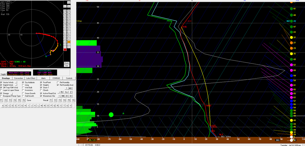
Over 50 knots of bulk shear with > 1500 MLCAPE within western Maine tomorrow evening on the 12z NAM ahead of that activity approaching from Quebec
-
And what people are not going to realize to when it comes to the power companies is a 38-like track would mean substantial power outages from LI through New England and probably even into eastern NY. All these markets would be tied up...we would obviously have to rely on help from other states but with the help that would be needed...I don't think we would be able to get the help needed. Obviously first priorities are going to be police/fire/hospital grids. Any people sharing those grids will be the luckiest...at least in terms of getting power restored quickest.
-
I think we may see 10%/45%/30% on new D2
-
Let's say a 1938-style hurricane were to be possible (same track, strength, etc). There probably would be some people which take the threat seriously, however, I'm nervous the vast wouldn't. I would assume, however, mandatory evacuations would be ordered at least for the coast which would help but most people I would think probably evacuate inland, particularly if they have friends/family in-state. But I don't think how many people realize just how bad the power outages situation would be. This would be an order of magnitude (or two) greater than Oct. 2011. 80-90% of the state would be without power for weeks and a large portion of that probably at least a month and it could be longer if any substations are completely destroyed. From my understanding, much of the equipment is build overseas and you just can't fly that stuff over, its gotta be shipped by boat and that stuff takes time to build as well. Grocery stores will have generators but could end up being some shortages of food and even gas. It would be ugly
-
Portland may get absolutely drilled.
-
It's a gusty flow too. Going to remain well mixed, especially with the front approaching
-
NBM argues BOS may not fall below 80F. BDL would have a legit shot of trying or even breaking their all time overnight low record
-
6z/13 NAM bufkit for BTV. About as impressive as an environment as you'll see around here out ahead of storms
-
Kind of shocked we don't have a general thunder area for Wednesday. I still think south of the Pike has chance for storms during the day and there would be a threat for strong/severe with any storms
-
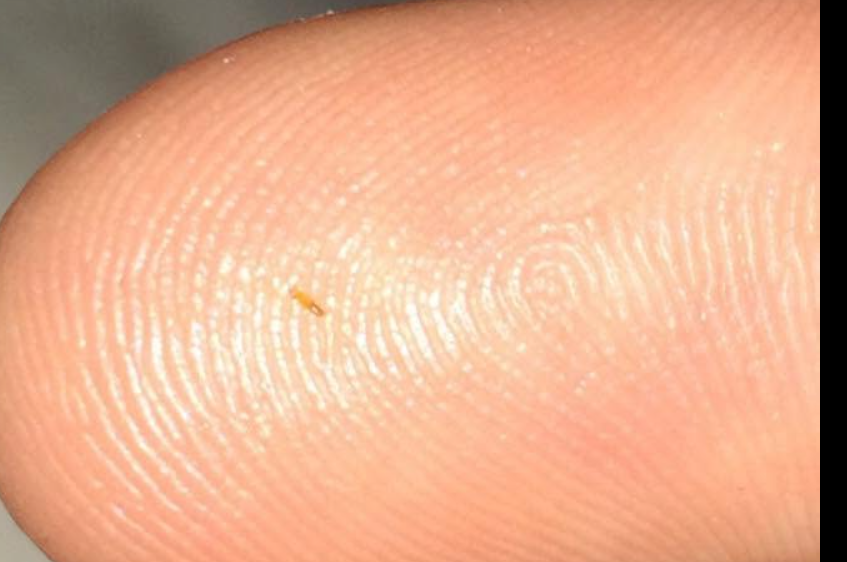
I don't think its a deer tick. This doesn't have the shape of a tick. I will try and catch a photo when I am outside tomorrow somehow. But I just did a google search (didn't try before because everytime you put something into google, the result usually is you're going to die). Anyways, I found a photo someone posted on Facebook and this kind of looks like it. The comments are no help Since I am posting someone's finger, here is the link so they get credit https://www.facebook.com/groups/485390939752444/posts/1043588527266013/
-
hmmm I don't think so. they look like a super tiny worm. They're literally like the width of a finger nail. If I tired to take a pic of some, they're so small the camera can't focus to capture it lol
-
I do think we have to watch Wednesday for some strong storms, particularly south of the Pike, despite NAM showing zilch for QPF.
-
Has anyone seen these before? They’re incredibly tiny orange big/insect…whatever. Sitting outside and feeling random spots of itchiness and I’ll see a super small orange looking thing and I’m guessing they bite or something because I’ll have a tiny red bite mark. No clue where they are coming from or what they are. They’re like those tiny red bugs that leave a blood dot but these are orange and even smaller.
-
Obviously this isn't going to impact many posters here and the population density isn't as high, however, this potential is deserving of its own thread. The potential exists for a rather significant severe weather event either late Tuesday afternoon or evening/overnight across northern New England. Daytime temperatures are expected to climb well into the 80's within the region and probably some spot 90's with dewpoints pushing into the lower 70's. This combination under the presence of an elevated-mixed layer characterized by mid-level lapse rates on order of 7+ C/Km will result in an extremely unstable atmosphere with MLCAPE values pushing or exceeding 3000 J/KG. While the timing of this event may be more evening or overnight, instability values will drop off due to the loss of daytime heating, however, MLCAPE values should remain around 1500+ J/KG. With the region on the northern periphery of a stout mid-level ridge that is centered over the northern Plains, strong flow will overspread the region with 60-70+ knots of 500mb flow, aiding in the potential for bulk shear values exceeding 50 knots. In addition, a strong surface cold front will be diving south. The combination of instability and wind shear ahead of the approaching cold front will set the stage for the development of one, or perhaps multiple clusters or lines of thunderstorms across Quebec which propagate across northern New England late in the day or during the evening or overnight. Given the ingredients, the potential exists for a concentrated swath of damaging wind gusts (perhaps some significant wind gusts), and if any supercells develop there will be a risk for large-to-very large hail, and even the risk for a few tornadoes (though this is largely dependent on storm mode and whether surface winds can remain more southerly ahead of the front.
-
No trees left in the Greens Mountain's?
-
Wagons north for this potential
-
more like way, way north
-
We are going to get skunked next week ughhhhhh
-
yup...just caught that.
-
Same here. Watch it be so anomalous that it has the complete opposite effect of what we'd think and it results in historic cold/snow across the country
-
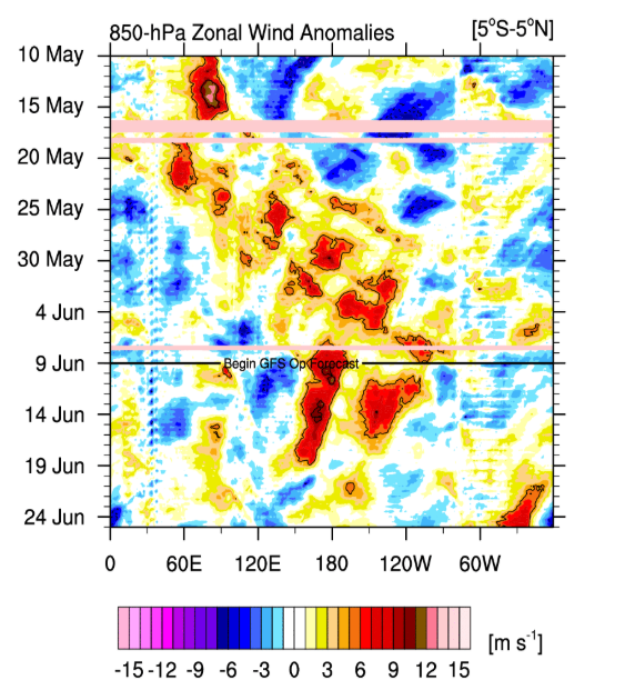
Gotta say...definitely impressive how the guidance for such an anomalous event have not backed down. About to have another impressive WWB too http://www.atmos.albany.edu/student/ventrice/real_time/timeLon/u.anom.30.5S-5N.gif EDIT: this is July not June
-
I don't think storm chances were ever particularly high for today. Always seemed more isolated
-
I still don't understand how ideas can be drawn on how a summer will be based on the concept of what *may* occur in terms of an ENSO event which is in the stages of development.


