

weatherwiz
-
Posts
81,145 -
Joined
-
Last visited
Content Type
Profiles
Blogs
Forums
American Weather
Media Demo
Store
Gallery
Everything posted by weatherwiz
-

December 2025 regional war/obs/disco thread
weatherwiz replied to Torch Tiger's topic in New England
One of the courses I have to do is a climate change course (well I think its an elective but I'm going to take it). Looking forward to that. Haven't read the info on it yet though so not exactly sure what would be covered. -
December 2025 regional war/obs/disco thread
weatherwiz replied to Torch Tiger's topic in New England
I wish the program I was in had a winter forecasting class, that would be epic. They had a severe weather forecasting class so not sure why no winter weather. Whenever I look outside and see snow on the ground or snowing I feel all wintry and that's when I enjoy the cold. Makes me want to winter and do more winter forecasting. -
So any updated head count?
-
December 2025 regional war/obs/disco thread
weatherwiz replied to Torch Tiger's topic in New England
Not often you see MET exceed MAV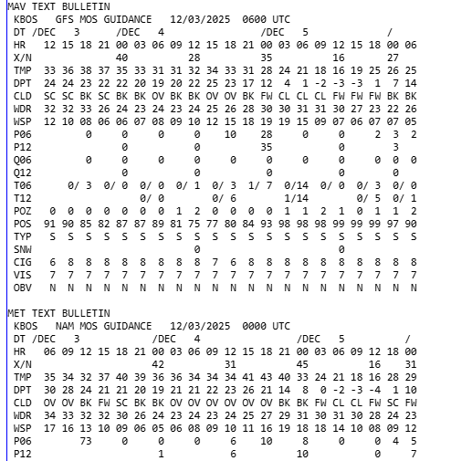
-
December 2025 regional war/obs/disco thread
weatherwiz replied to Torch Tiger's topic in New England
Might be a bit stronger WINDEX signal back across north-central New York towards Albany. A quick look doesn't seem to be the case around here but could certainly see some heavier snow showers whiten things up quickly. Would be like mid-to-late afternoon too so definitely localized travel impacts possible -
December 2025 regional war/obs/disco thread
weatherwiz replied to Torch Tiger's topic in New England
These more often that not have some sort of wintry precip ahead of them. Sometimes even more widespread than guidance will indicate too. -
December 2025 regional war/obs/disco thread
weatherwiz replied to Torch Tiger's topic in New England
Did someone mention about snow showers tomorrow? Wouldn't be surprised to see some heavier snow showers move through, probably mainly up to about 91 though and far NW CT, as well as SNH into NE MA -
December 2025 regional war/obs/disco thread
weatherwiz replied to Torch Tiger's topic in New England
I've been up in Springfield (northeast of downtown) for the last 3 years or so (but getting back to Connecticut hopefully sometime soon). I ended up with 4" which was right on the upper end of what I was anticipating over the weekend. The way it was going yesterday I thought I'd have a shot for maybe 6-7" but as soon as I mentioned that, the snow stopped and we went to freezing rain. Probably got close to 1/10" of accretion. But yup...if we can muster up multiple 2-3" events in the next few weeks, that starts adding up quickly. -
December 2025 regional war/obs/disco thread
weatherwiz replied to Torch Tiger's topic in New England
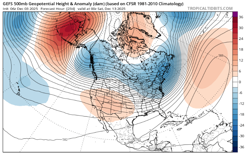
That jet is going to be absolutely cranking It's not an awful look either around mid-month...window may be small but there is certainly some chance Getting anything to phase in that will be difficult but you could feasibly have a shot to get some PV interaction and before you know it, you have a good signal for cyclogenesis in our hood.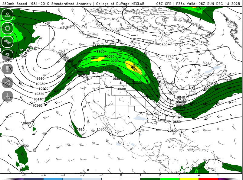
-
December 2025 regional war/obs/disco thread
weatherwiz replied to Torch Tiger's topic in New England
That 10th-15th period...maybe even a few days beyond that could certainly be something to watch as we get some PV lobes thrown our way -
December 2025 regional war/obs/disco thread
weatherwiz replied to Torch Tiger's topic in New England
WTF? Several of what you said here is ridiculous but this just takes the cake. -
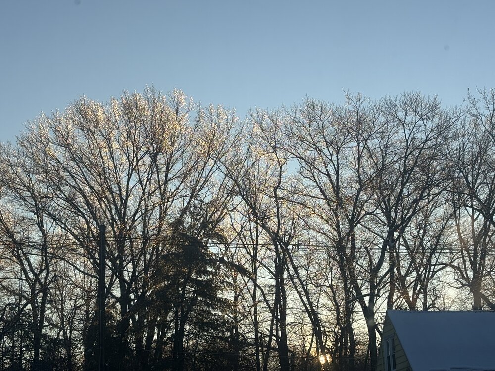
Best part about ice accretion is when the sun rises the following morning
-
Just went outside and wow…it’s all basically a sheet of ice. Hard to tell because it’s dark but some definite accretion on the trees at least. It’s also like snowing/sleeting.
-
December 2025 regional war/obs/disco thread
weatherwiz replied to Torch Tiger's topic in New England
Patterns like this you can tell in the weather social media world who just rips and reads SLP charts. All of a sudden the models at D3 will develop a QPF blob and people will go, "where did this come front, models didn't have this". Meanwhile that possibility was there for several-plus days. -
I don't think they do, unless they've changed that but might be worth it to ask. I can give a call tomorrow.
-
December 2025 regional war/obs/disco thread
weatherwiz replied to Torch Tiger's topic in New England
I'll take a barrage of clipper threats. Several 2-4/3-5" clippers start adding to the seasonal total quickly. -
Miserable time shoveling the driveway and a stretch of road in front of the driveway. Only took me a bit over an hour but it was moderate rain and I got soaked and the snow on the ground started to get water logged.
-
Time to go out and clean before hockey. Glad I got my high noon for the game tonight the other day instead of waiting for tonight
-
ha, as I type that it's flipping back to snow!!!
-
This freezing rain is kind of pissing my off right now. Have to go outside and clean and the freezing rain will make it worse...not too mention it's probably better to wait for it to stop then clean but hockey is on at 7.
-
This is 10000000000000000% better than the constant barrage of snow maps
-
4" but its sleeting. ughhhhhhh BS boooooooooo
-
well that was brief...all of a sudden it stopped
-
starting to come down heavier again and flake size has improved somewhat. but it has that look of a "wetter" snow
-
in a bit of a lull right now but no signs of any pinging which is great as I would expect mixing to become more probably with lighter intensities. radar looking good though off to the southwest


