

weatherwiz
-
Posts
81,145 -
Joined
-
Last visited
Content Type
Profiles
Blogs
Forums
American Weather
Media Demo
Store
Gallery
Everything posted by weatherwiz
-

December 2025 regional war/obs/disco thread
weatherwiz replied to Torch Tiger's topic in New England
Our best chance for something bigger later this month is hoping for any PV lobes to phase in with the northern stream. Just picking a random time frame just to illustrate but the PV is forecast to become quite large which will benefit us in the since that every now and then we'll get pieces of PV lobes tossed our way. But I feel like overall we need to weaken the PV and that may help relax the flow a bit. But there is also extremely uncertainty with how the AO evolves the second half of this month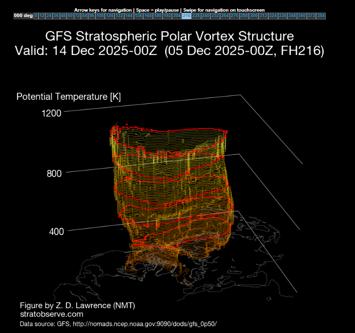
-
December 2025 regional war/obs/disco thread
weatherwiz replied to Torch Tiger's topic in New England
Someone could probably do better from weatherbell or something but this is from weathermodels (don't see of anyway you can just select frames like you can on cod) and this goes way too quickly lol. Anyways, there are subtle differences between the Euro and GFS (GFS a bit more amplified with the ridge) but the subtle differences have a significant impact on the evolution. This is precisely why these patterns are extremely difficult to forecast in. The most subtle of differences can mean the difference between a 4-8" event and a C-2" lol.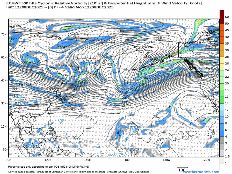
-
December 2025 regional war/obs/disco thread
weatherwiz replied to Torch Tiger's topic in New England
I just hope its right but the models have struggled greatly within this domain. -
December 2025 regional war/obs/disco thread
weatherwiz replied to Torch Tiger's topic in New England
I guess this is the feature to watch over the next day or two (Coming out of the Aleutians). How this evolves in the next 48 hours will likely tell us whether the ridge will amplify or not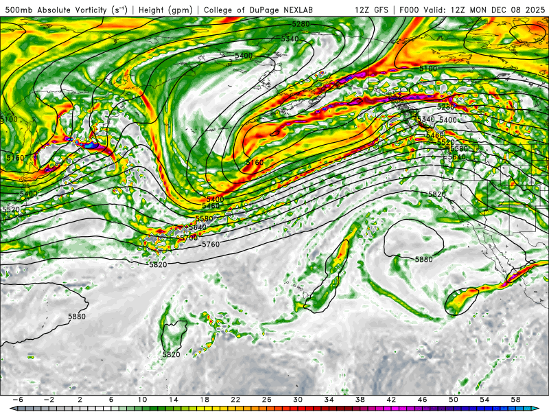
-
December 2025 regional war/obs/disco thread
weatherwiz replied to Torch Tiger's topic in New England
I think the framework the follow up wave sets up is way more important than worrying about whatever the ridge in the West will do. This how the west ridging will unfold game the last few years has done absolutely nothing. We've countless times seen models trend well with that inside 96-120 hours...only for a total slap back in the other direction, even inside 72 hours. I am willing to bet by 12z guidance Wednesday, we see guidance scale back with that ridging. -
December 2025 regional war/obs/disco thread
weatherwiz replied to Torch Tiger's topic in New England
The good news is the Euro has been pretty consistent with the wave moving from the northern Plains across the Great Lakes region in the Thursday-Friday timeframe (its wavered with timing) but its been dead consistent since Friday. This wave is important because, while it may not do anything for us, it likely sets the stage for the "potential" with that follow up wave for the weekend. -
December 2025 regional war/obs/disco thread
weatherwiz replied to Torch Tiger's topic in New England
Our only hope of amplifying the ridge across the West for that mid-month period is if it connects with the ridging over Alaska. But dating back to even the last few years, we have seen countless times models in the extended range want to develop these beautiful ridges in the West only for it to either not verify, or its duration was too short to have any meaningful influence downstream. Something has to change within the background state for this to actually happen, not just "the EPS wants to do this at xxxx time"). It's pretty unfortunate but the pattern is setup to favor weak clippers and shredded garbage. But for some reason...it must be something within the model physics we keep seeing these tendencies to overamplify things within a specific time range (and I even fell for this with last nights potential). But people will keep falling for it and trying to come up with ways to justify as to why "it needs to be watched". -
Probably ended up with anywhere from 1/4” to 1/2” of snow.
-
December 2025 regional war/obs/disco thread
weatherwiz replied to Torch Tiger's topic in New England
Yup. There is nothing wrong with several 3-5" type ordeals. And we see plenty of potential for that on guidance. If anyone is just looking for 8-12"+ storms all the type...they're going to be disappointed 99% of the time. I believe BDL is already at average or even slightly above for the season...and its only Dec 5. I don't remember off-hand what BDL's average Dec snow is but I don't think its any more than 5 or 6". Another one of these 2-3" storms for them in the next 26 days and it was an average month. -
December 2025 regional war/obs/disco thread
weatherwiz replied to Torch Tiger's topic in New England
This is also where patience is required and remembering climo. As I stated earlier, if you have a favorable pattern, you need to cash it. Whether that is early winter, meat of winter, or late winter. If you were to look at average to above average seasons, its almost 100% likely we cashed in during those favorable periods. But I mean, for the most part its like early January into early March where our climo really is. I mean look at Boston...was it 2014-2015? they went into February below average and pulled off what like 100" in 6 weeks? There other component to this is, I think the term "favorable" pattern is really becoming overplayed. Let's be serious, the batting average on these "favorable" patterns the last several years is so low that it makes Conner Wong's average look HOF worthy. I think there's been way too much stock and emphasis on the EPS these last several winters and using that to make bold statements and claims. Obviously, when looking medium and extended, EPS is your friend...there really isn't any other tool. But I think the EPS has to be taken with less weight in these pattern regimes. Because of the smoothing of the EPS its making patterns probably look better than they really are. They are just smoothing out the chaos and its the chaos in these fast flows which is acting as the inhibitor. -
December 2025 regional war/obs/disco thread
weatherwiz replied to Torch Tiger's topic in New England
Trying to garner trends of precipitation and something like snow cover to influences of CC is nearly impossible to do because of the variability involved. The better metric is trying to determine how CC has influenced the larger scale oscillations, ENSO, Hadley Cell, etc and how weather patterns are behaving now versus earlier in the record books. Now, you can argue the smaller scale phenomena (precipitation, snow cover) is a product of the pattern, however, not every similar pattern is going to produce similar outputs. Not every trough digging into the East during the winter is going to elicit a major winter storm, not every trough digging across the West and progressing into the Plains in late May is going to yield a 5/3/99 or April 0f 2011. -
You know what we should have done like 10-15 years ago. Got a group and rented a cabin or something in the middle of nowhere during a major snowstorm. Just imagine how fun that would have been
-
December 2025 regional war/obs/disco thread
weatherwiz replied to Torch Tiger's topic in New England
yeah there isn't anything fun about this at all, unless it is actually physically snowing out. The snow on the ground makes the landscape all cool and all but it does nothing to help with 0F temperatures. If its 90 with a HI of 105 in the summer, you can still at least be outside, even if its just sitting in the shade, or in the pool, or pool side. Who really is going outside to "chill" in a lawn chair with a beer at 0f? -
No worries. I would have chosen this over what I'm doing but it's something I already paid for lol. I know last year we briefly discussed an early spring one but never got to it. Maybe late January we can throw a thread up with some dates for March or April
-
December 2025 regional war/obs/disco thread
weatherwiz replied to Torch Tiger's topic in New England
This is a true statement. Doesn't matter if its early December, mid-February, or early March...if the pattern is favorable you need to cash in. It's like sports and lets say baseball...its a long season but if you aren't winning the games you need to in April or May, those losses will come back to bite you come late September. -
December 2025 regional war/obs/disco thread
weatherwiz replied to Torch Tiger's topic in New England
Hopefully this is the coldest weather of the system. We can still get snow and not have it be 0. You know when it's cold when there is steam emitting from the dog poop. -
meh how'd this date planning go for you
-
December 2025 regional war/obs/disco thread
weatherwiz replied to Torch Tiger's topic in New England
yup...ultimately I think the GFS will end up a bit on the overdone side but I think we'll see the underdone guidance come up some. -
December 2025 regional war/obs/disco thread
weatherwiz replied to Torch Tiger's topic in New England
well what I said though wasn't inaccurrate...it is hard to get warning criteria in cutters -
December 2025 regional war/obs/disco thread
weatherwiz replied to Torch Tiger's topic in New England
whoops...meant to say clipper lol -
December 2025 regional war/obs/disco thread
weatherwiz replied to Torch Tiger's topic in New England
Yeah...I think someone east would have a chance to pull off a warning criteria snow. ORH bufkit looked pretty solid...solid lift into DGZ and ratios upwards of 18:1. -
December 2025 regional war/obs/disco thread
weatherwiz replied to Torch Tiger's topic in New England
18z GFS would probably verify low end warning criteria somewhere. warning snows tough to get with cutters but someone would probably pull it off -
I believe he said he could. If more people are game for the 13th then definitely switch. Hopefully we can get a spring one too...like March before everyone starts summer activities.
-
December 2025 regional war/obs/disco thread
weatherwiz replied to Torch Tiger's topic in New England
yeah has a nice little axis of precipitation from E CT on east -
December 2025 regional war/obs/disco thread
weatherwiz replied to Torch Tiger's topic in New England
HRRR remains quite aggressive for tomorrow night into Sat


