weatherwiz
-
Posts
81,148 -
Joined
-
Last visited
Content Type
Profiles
Blogs
Forums
American Weather
Media Demo
Store
Gallery
Everything posted by weatherwiz
-

First Winter Storm to kickoff 2025-26 Winter season
weatherwiz replied to Baroclinic Zone's topic in New England
Doesn't look as impressive with the fronto band but was pleasantly surprised when I clicked northern ORH county. Despite the high DGZ that's some potent lift into it -
First Winter Storm to kickoff 2025-26 Winter season
weatherwiz replied to Baroclinic Zone's topic in New England
Yeah you may see most of those locals only get to like 33F or so. I always think a true flash freeze is overrated around here, but tomorrow is interesting. It will get down into the 20's tonight so these paved surfaces will get cold. I guess we'll see what kind of treatments are applied, but with precipitation falling much of the day and then dropping below freezing through the evening and back into the 20's...things could slick up quick if not treated. -
First Winter Storm to kickoff 2025-26 Winter season
weatherwiz replied to Baroclinic Zone's topic in New England
yup...even NAM bufkit has it too. Definitely something to watch. Could have some impact for the evening, particularly later evening commute but could make for a slew of delays out of BOS in the evening. -
First Winter Storm to kickoff 2025-26 Winter season
weatherwiz replied to Baroclinic Zone's topic in New England
Overall profile is a bit toowarm but GFS bufkit does flip BOS to a couple hour period of heavy snow during the evening on the backside...even drops a quick inch or two. -
First Winter Storm to kickoff 2025-26 Winter season
weatherwiz replied to Baroclinic Zone's topic in New England
Only people sniffing 10:1 ratios with this is going to be closer to CNE and probably into ME. Other than that, anyone snow down here is probably going to be closer to 8:1 -
First Winter Storm to kickoff 2025-26 Winter season
weatherwiz replied to Baroclinic Zone's topic in New England
really? hmmm...I always thought it was around this time with DST. But good to know, thanks! -
First Winter Storm to kickoff 2025-26 Winter season
weatherwiz replied to Baroclinic Zone's topic in New England
Don't forget changing the clocks. It was 1:00-1:15 but now 12:15 with the time change. -
First Winter Storm to kickoff 2025-26 Winter season
weatherwiz replied to Baroclinic Zone's topic in New England
Euro may try to get Kevin a few inches on the backside -
First Winter Storm to kickoff 2025-26 Winter season
weatherwiz replied to Baroclinic Zone's topic in New England
meh how'd those physics work out for you -
First Winter Storm to kickoff 2025-26 Winter season
weatherwiz replied to Baroclinic Zone's topic in New England
I would wager that you have decent odds at getting your covering and maybe even around 0.5" or so. I think some of the guidance is too aggressive with warming sfc temperatures so quickly. I understand too its the temperatures aloft which are a concern too but I think they will still be cold enough initially to support snow. But at the surface, dewpoints will still be into the upper 20's and probably some room to wet bulb at the initial onset of precipitation which should help to keep temperatures just cold enough. -
First Winter Storm to kickoff 2025-26 Winter season
weatherwiz replied to Baroclinic Zone's topic in New England
Just a question of where that is but the most likely scenario is probably from Maine (just inland from the coast) back through CNE. I do wonder if there is some room to pop some 8-10" within that band. -
First Winter Storm to kickoff 2025-26 Winter season
weatherwiz replied to Baroclinic Zone's topic in New England
IDK...what may prevent that idea is overall flake size might be pretty putrid. Have to wait another 56 minutes for bufkit but panning around some soundings that DGZ is awfully high. It's also difficult to find really any extraordinary lift that barely gets to the base of the DGZ. I think we'll see a narrow area where snowgrowth is excellent for a period of time, but that may be brief. Snow rates will probably be heavy but the flake size is going to be putrid. You'll have to go into NH and ME to really get the good stuff. I'm thinking 3-4" of snow is going to be the most common and widespread within the questionable areas which should hold back any power outage/damage risk. Max totals probably 5-8" into NH/ME. -
First Winter Storm to kickoff 2025-26 Winter season
weatherwiz replied to Baroclinic Zone's topic in New England
The overall differences between NAM/Euro/GFS seem rather subtle but these subtle differences have significant ramifications into how this unfolds. All kind of seems to be tied into exactly where/when the sfc low becomes more defined and where/when 925/850 lows develop and close off. Of course, there is still the signal in the potential for dual lows. Regardless, this will be a nice hit from parts of Maine through central NH, southern VT and into western MA. Also wondering if we see a secondary smaller max from like Worcester into SE NH -
First Winter Storm to kickoff 2025-26 Winter season
weatherwiz replied to Baroclinic Zone's topic in New England
Just northwest of that R/S line is going to rip. That's a nice fronto band that materializes on the NAM. A little concerned though because the DGZ is on the higher side so it will take some heft upward vertical motion to really crank out good growth and rates but that is doable across a narrow swath. Hell, there may also be some thunder/lightning that scrapes the Outer Cape. -
First Winter Storm to kickoff 2025-26 Winter season
weatherwiz replied to Baroclinic Zone's topic in New England
guessing its probably 18z tomorrow when NAM starts to tame down. -
First Winter Storm to kickoff 2025-26 Winter season
weatherwiz replied to Baroclinic Zone's topic in New England
Kevin gets dry slotted though most of QPF probably done -
First Winter Storm to kickoff 2025-26 Winter season
weatherwiz replied to Baroclinic Zone's topic in New England
Can't wait to see how amped the NAM turns out to be based on the look so far. -
First Winter Storm to kickoff 2025-26 Winter season
weatherwiz replied to Baroclinic Zone's topic in New England
Isn't Google DeepMind the one which has had extremely encouraging results, however, also described as "the model is able to produce great results, however, the model has no clue how it derived the results". There was some article or paper on this a year or two ago. -
First Winter Storm to kickoff 2025-26 Winter season
weatherwiz replied to Baroclinic Zone's topic in New England
doing both -
First Winter Storm to kickoff 2025-26 Winter season
weatherwiz replied to Baroclinic Zone's topic in New England
ughh something wonky must be going on with bufkit profiles from PSU. keep forgetting to make a backup bufget list from iowa state. -
First Winter Storm to kickoff 2025-26 Winter season
weatherwiz replied to Baroclinic Zone's topic in New England
my thinking too...hope that is overdone. doesn't look like a ton of convection associated with this across the SE -
First Winter Storm to kickoff 2025-26 Winter season
weatherwiz replied to Baroclinic Zone's topic in New England
yup...and too much data created to "save people time" while degrading forecasting skill. Hey, why do I have to spend an hour or two assessing all the critical factors which influence snowfall totals when I can just pull up a 10:1 map, call it a forecast, then blame the model for being wrong when it doesn't pan out. Or significant tornado parameter map is showing widespread values of 4-5...let's go with tornado outbreak! its gross. -
First Winter Storm to kickoff 2025-26 Winter season
weatherwiz replied to Baroclinic Zone's topic in New England
Forecast models haven't gotten worse, what has gotten worse over the last decade is forecasting skill and a large part of that is due to all of these ridiculous products which have supplemented the actual forecast process. So many convective events in the Plains hyped up because of supercell composite and significant tornado crap, snow maps, etc. It's all run to snow maps, QPF output, etc. which more often than not will not produce an accurate assessment and then when they don't verify, its cry and blame models rather than taking personal responsibility. -
First Winter Storm to kickoff 2025-26 Winter season
weatherwiz replied to Baroclinic Zone's topic in New England
I wouldn't be surprised to see the euro come back the other way a bit tomorrow but something like this run may not be too far off from what occurs -
First Winter Storm to kickoff 2025-26 Winter season
weatherwiz replied to Baroclinic Zone's topic in New England
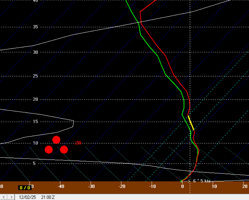
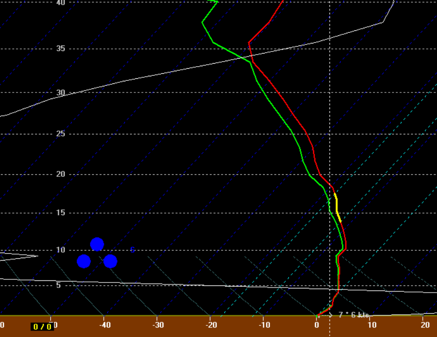
the 12z GFS bufkit for ORH is odd. I don't really put too much stock into the precip type but it has this look as heavy ZR. It's more than likely a lift thing but it's still funny to see. but then has this as heavy snow