weatherwiz
-
Posts
81,148 -
Joined
-
Last visited
Content Type
Profiles
Blogs
Forums
American Weather
Media Demo
Store
Gallery
Everything posted by weatherwiz
-

Overnight Wednesday, November 5, 2025 Wind Event
weatherwiz replied to weatherwiz's topic in New England
I also wish this would have busted with the LLJ that was advertised a few days ago versus busting because the LLJ just didn't pan out. If we got the 50-60 knot LLJ, I wonder if last night would have performed or not. I find these setups to be interesting, whether its 35-45 mph gusts or something that has potential for 50-60 mph. Over the years we've had plenty of times where wind advisories (this includes high wind) were issued and nothing happened, and times it's like "where the heck is the wind advisories". I am also wondering if the showers helped to develop or enhance a subtle inversion above the surface which maybe knocked off like 10 mph of gust potential? Was looking at some 6z NAM bufkit soundings and there are some subtle inversions just above the sfc. -
Overnight Wednesday, November 5, 2025 Wind Event
weatherwiz replied to weatherwiz's topic in New England
Looks like the core of gusts last night was basically between 11 PM-2 AM just looking around at some obs which falls in line what guidance started to indicate but pretty crazy the decrease in LLJ intensity in the course of two days. -
Overnight Wednesday, November 5, 2025 Wind Event
weatherwiz replied to weatherwiz's topic in New England
56 mph gust at BGM and 54 at AVP. Also 66 mph at HTS…best west southwest just like summer Edit: HGR, not HTS -
Overnight Wednesday, November 5, 2025 Wind Event
weatherwiz replied to weatherwiz's topic in New England
Nice line went through northeast PA. See if that can hold through Fairfield county -
Overnight Wednesday, November 5, 2025 Wind Event
weatherwiz replied to weatherwiz's topic in New England
Gusts cranking for sure out there -
Overnight Wednesday, November 5, 2025 Wind Event
weatherwiz replied to weatherwiz's topic in New England
I would LOVE to experience a Great Plains blizzard some day. That has to be some wild stuff...that and a major LES event. -
Overnight Wednesday, November 5, 2025 Wind Event
weatherwiz replied to weatherwiz's topic in New England
Compared to the South, sure we do winter well but just speaking in terms of an average winter, we are nothing special versus the interior West, northern Plains, upper-Midwest. Outside of higher elevations and northern New England (because of latitude) our average winter isn't wild...what around 30" towards the coast (probably even a bit less) and upwards of 35-50" across the interior? What is the most common snow storm for the region...3-6" 4-8"? That's probably not much different than these other areas and those other areas...get true blizzards. There's no doubt winter storms trump other weather phenomena here, but they are still relatively meh compared to other regions of the country. But this is just looking at severity of weather elements. If we want to talk societal impact that's a different argument. -
Overnight Wednesday, November 5, 2025 Wind Event
weatherwiz replied to weatherwiz's topic in New England
That's the thing...we really don't do high end wx in the Northeast well at all and the return time between high end weather is quite long. This includes severe weather, tropical, and yes this includes winter weather too. Outside of the Southwest, IMO we are the most mundane country in the region. I'd even put the Northwest slightly above us because Fall/Winter/Spring they can get some high impact storms with high winds, widespread power outages, the significant mountain snows which causes closures of travel passes and stretches of highways. Sure out of these, the return rate of snowstorms > 12" over a widespread area is much higher, but at the end of the day, our winter storms aren't extremely impactful. How often do you see stretches of 84, 91, 95, etc close during the winter storm? Go into the central Plains, northern Plains, Northwest...you can getmultiplel hundred mile stretches of closures along I-80, I-90, I-94, I-25, etc. If you take the intensity of weather elements we receive here and compare to other regions...the extent of the severity we see is pretty meh compared to anywhere else. -
Overnight Wednesday, November 5, 2025 Wind Event
weatherwiz replied to weatherwiz's topic in New England
I am really curious to see what moves through this evening (this would be fore Mass though and far northeast CT) in terms of a low topped line. There are some subtle hints at some very weak instability along/just ahead of the line as 500mb temperatures quickly cool and lapse rates steepen. -
Overnight Wednesday, November 5, 2025 Wind Event
weatherwiz replied to weatherwiz's topic in New England
Looking at some 12z NAM bufkit locations we're still looking at 45-50 mph gusts region wide but there may still be a sliver of a window where there could be some gusts in the 55-60 range somewhere. Many soundings still have ~50 knots at the top of the mixed layer. Obviously this doesn't guarantee that translates to the surface. -
Overnight Wednesday, November 5, 2025 Wind Event
weatherwiz replied to weatherwiz's topic in New England
It's still going to get quite windy tonight and there is still the risk of localized wind damage if an organized convective line can develop to our west today and maintain as it crosses the region tonight. But for a good 4-5 hours overnight it will still be very windy. There will still be some trees/limbs that come down and there will be some power outages. -
Overnight Wednesday, November 5, 2025 Wind Event
weatherwiz replied to weatherwiz's topic in New England
Just looking through quickly it does seem we may be looking at more 45-50 mph gusts potential than the 55-60. Doesn't seem like a big difference but that is a pretty big difference in terms of potential for power outages and tree damage. -
Overnight Wednesday, November 5, 2025 Wind Event
weatherwiz replied to weatherwiz's topic in New England
Waiting on the 18z HRRR bufkit but the 18z HRRR has a pretty solid line moving through which may or may not contain some thunder/lightning. There are some important notes about this to keep in mind: 1) Typically (probably often) we don't see much in the way of wind transported down to the surface within these lines in this kind of setup. There are several reasons for this, however, perhaps the most important is the air becomes too stable too quickly, inhibiting winds from mixing to the surface. 2) The presence of any thunder/lightning (as we saw last night) increases the potential for strong winds to make it to the surface via downward momentum transfer and this indicates the presence of instability. The challenge tomorrow evening will be, will the weak instability we may have be just enough to aid in this process? 3) In terms of the region as a whole, the winds will likely begin to increase significantly and quickly just behind the line. You'll have strong CAA advecting within the 1-3km level which is going to vastly increase your low-level lapse rate - this will be the catalyst for mixing down stronger winds. Also, there may be some evaporative cooling going on just behind the line (as we may still have some llvl moisture present) which will further help to initially mix down winds. 4) There are always going to be very local mesoscale and microscale processes which will have a great impact locally. With this, we will likely see this either perform accordingly or maybe even slightly overperform within areas which are prone to higher wind events. Subsequently, there will be areas where the wind doesn't seem impressive at all. That has nothing to do with the setup, that is a product of microscale processes and local topography. (This is something that also can be applied to just about any weather event). But with many forecast soundings showing nearly a dry adiabatic profile up though 3-4k with a drying profile, we should mix sufficiently...but there could be some caveats such as if there happen to be any subtle just above sfc inversions. If this was coming during the day it would be difficult to find any concerns -
November 2025 general discussions and probable topic derailings ...
weatherwiz replied to Typhoon Tip's topic in New England
This is a different breed than what we typically see for "wind setups". Much different than those southerly wind events which always get hyped and overplayed -
A potent shortwave trough will continue amplifying as it progresses across New England characterized by a narrow 130+ knot jet streak rounding the base of the trough. Amplifying trough with diffluent upper-level flow will help strengthen a west-to-east surface low across the Great Lakes region across northern New England while lifting a warm front from southwest to northeast across the region during the day and a cold front through during the evening. There are two potential hazards with this system: 1) Convective showers (which may or may not contain lightning) moving through during the evening ahead of the cold front. - Forecast model guidance yields very weak surface based instability as dewpoints climb through the 40's under steepening lapse rates. Given the combination of increasing flow aloft and inverted V signatures on many forecast soundings, these showers will have potential to produce localized damaging wind gusts with evaporative cooling aiding in the transport of downward momentum. There is potential for convection to blossom, especially towards eastern Mass and Cape Cod in which there could be a small window for some more concentrated pockets of damaging wind gusts and perhaps even a brief tornado. 2) Behind the passage of the cold front, strong CAA ranks from the northwest as the low-level flow continues to significantly strengthen for several hours. Forecast model soundings yield very strong mixing up through 3-4K resulting in very steep low-level lapse rates. Given potential for 50+ knots of wind at 850mb and favorable thermal profile to tap into these winds, a several hour period of wind gusts in the 45-55 mph range are likely; including potential for some gusts upwards of 55-65 mph in the typical wind prone areas. Scattered power outages are likely due to the strong winds.
-
November 2025 general discussions and probable topic derailings ...
weatherwiz replied to Typhoon Tip's topic in New England
Time to make a thread because I feel like it -
November 2025 general discussions and probable topic derailings ...
weatherwiz replied to Typhoon Tip's topic in New England
I would not be shocked to see convective blossom towards the Cape tomorrow night -
November 2025 general discussions and probable topic derailings ...
weatherwiz replied to Typhoon Tip's topic in New England
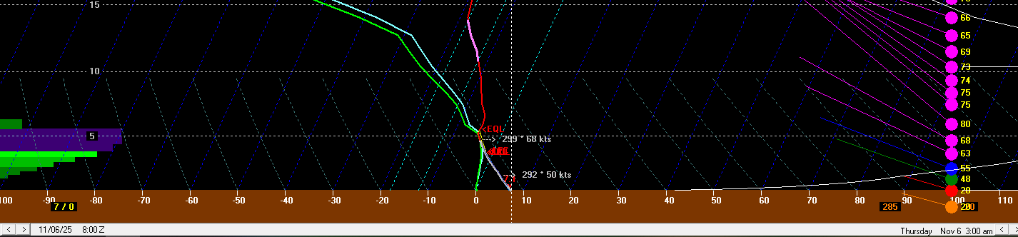
This is one of the more intriguing modeled wind setups we've had in a while. This is 12z NAM bufkit for BDL and for 2 AM. Like Scott said above, also have to watch for gusty showers/thunderstorms which could bring some locally damaging wind gusts but we should crank on the WNW flow. Strong pressure gradient and strong mixing overnight. Maybe some spots end up with just a bit of a near sfc inversion to keep the strongest gusts more to tree top level but there will be some 60+ mph gusts tomorrow night I'd think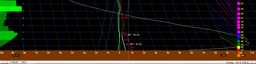
-
November 2025 general discussions and probable topic derailings ...
weatherwiz replied to Typhoon Tip's topic in New England
Looking quite interesting tomorrow evening/overnight -
November 2025 general discussions and probable topic derailings ...
weatherwiz replied to Typhoon Tip's topic in New England
The core of the winds moves through Wednesday night. It will be windy Thursday morning to begin, but gusts subside through the morning -
November 2025 general discussions and probable topic derailings ...
weatherwiz replied to Typhoon Tip's topic in New England
18z NAM trended a bit more towards the GFS with the wind potential Wednesday night -
November 2025 general discussions and probable topic derailings ...
weatherwiz replied to Typhoon Tip's topic in New England
This was 6z GFS for IJD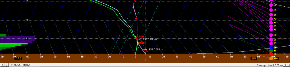
-
November 2025 general discussions and probable topic derailings ...
weatherwiz replied to Typhoon Tip's topic in New England
Well 12z GFS did not really back down. But as a reference for what is being discussed, here is a point-and-click sounding from within northeast Connecticut. That is a very well mixed lowest 1km (nearly dry adiabatic) with 50+ knot winds at 850mb. Very dry below the 850mb level too which would further enhance downward momentum. -
November 2025 general discussions and probable topic derailings ...
weatherwiz replied to Typhoon Tip's topic in New England
Yeah I wouldn't be surprised if it's toned down a bit with the 12z runs but I guess we'll get an idea when the NAM rolls out and whether it falls towards the GFS/Euro. The NAM isn't too far off from the GFS but the GFS has a narrow ribbon of 130+ knots at 500mb along the base of the shortwave...that's wild stuff. -
November 2025 general discussions and probable topic derailings ...
weatherwiz replied to Typhoon Tip's topic in New England
Too bad that isn't coming through during the day, probably could get a few strong convective cells. But maybe some heavy graupel showers as that rolls through overnight. But yeah that is an impressive wind signal (at least on the GFS) with steep llvl lapse rates and 925mb winds >50 knots.