weatherwiz
-
Posts
81,148 -
Joined
-
Last visited
Content Type
Profiles
Blogs
Forums
American Weather
Media Demo
Store
Gallery
Everything posted by weatherwiz
-
I guess its spider season. My girlfriend said she killed a big yellow one that was crawling on a door yesterday, then one last night that dropped from the ceiling, and I just had one run across my desk ughhhhhhh. There must be a nest and I'm still convinced there is a nest in my car since i had 3 spiders crawl on me while driving in the span of 10 days. Frustrating
-
1" of rain and EF1 TOR's
-
TDS northeast of Rockland
-
There is a very weird obsession with the HREF...ever since it nailed some event a few years back (forgot what it was). But that's what forecasting is evolving into...pick a model and output source that displays beautiful visuals and construct what its showing into a "forecast".
-
I think the HREF is kind of meh overall. I mean there are times it does great but there are many times it way overdoes things
-
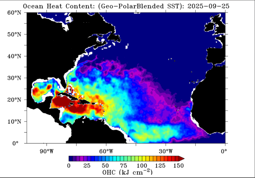
Once we start to get something a bit more organized we should get a better idea. The "center" has been jumping like crazy over the last day, particularly since last evening. Once concern I have though is potential for RI if this 1) gets its act together quickly and 2) If it tracks within the zone of higher OHC Doesn't mean anything for us but I would be watching extremely closely anywhere from the northeast Florida coast up to coastal NC.
-
Yes, you're right...I got my invests mixed up
-
Also AL93 is what would need to develop for any EC interest and it looks like AL94 will be the one
-
If anything came up the coast it would transition to a cold core system so quickly. It would lose its tropical characteristics upon getting off the Carolina coast. "Worst case" scenario is some much needed rain and probably 30-40 mph gusts, mostly at the coast. And that is even fantasy
-
I'm intrigued as well. Certainly something to watch, but like you said, all speculation at this point until we get something to really develop. Lots of factors shall influence that these next few days. I just hope nobody is really expecting a cat 3 here I mean extratropical, subtropical, etc. storms can certainly still be noteworthy so don't want to take away from that aspect.
-
And Gabrielle has taken off. RI and up to 120 mph
-
Doubt it would be a cane up here, waters are pretty chilly but maybe a glorified Nor'easter with gusty winds and some heavy rain and of course some high surf.
-
Crazy how much cooler it feels once the sun goes behind the trees. That’s what separates this from true summer. Even when the sun goes behind trees or isn’t beating on you, it’s still hot.
-
Beautiful day to sit outside with an IPA and watch college football

-
Agreed on that, but I think exactly how December progresses and evolves will play a larger factor in the remaining months. So December essentially sets up the rest of the way...but then of course you start introducing other wild cards that will come into play.
-
Also keep in mind 1.2 is the most volatile region so when assessing changes in SST structure you must factor in what the contributions are to that.
-
I don't see ENSO being much of a factor in the overall regime this winter, or if anything, any influences of ENSO would be minimal for us. Given this, IMO, the biggest driver for the winter pattern across North America is going to be totally dominated by the PDO and secondly by short-term influences on the NP/PNA. At least in terms of SST structure, we are in a rather remarkable negative PDO right now and to the point of where you don't even have the strip of below average SSTs along the west coast of North America from the PAC NW into the Gulf of Alaska. Now, this could be a great thing and it could be a very bad thing. One big wild card I think will have to do with the Aleutian Low. Despite the -PDO last winter the Aleutian Low was relatively strong (though displaced towards the dateline) and that that didn't help us at all. One worry I have though is we are going to continue with the theme of very fast flow alot and something more along the lines of zonal (gradient). This would yield another super challenging short and medium range forecasting with models struggling with shortwaves, shortwave interactions, and storm evolution. A counter would be getting substantial help from the Arctic domain but my worry is much of our source region is going to be flooded with milder (with respect to climo) temperatures so even if we get a "good look Arctic" the delivery of "colder" temperatures is crap.
-
Its a solid shortwave (though becoming more of an open wave) with decent dynamics and forcing. This certainly isn't going to provide relief region wide but some folks will get lucky and get some rain.
-
There will be showers and thunderstorms around Tuesday, could even see an axis of some heavier rain up north (or in the vicinity of the warm front).
-
Maybe some strong storms Tuesday if timing works out
-
yup...oh well. It was fun to look at while it lasted
-
Probably one of the better hail setups we've had in quite some time.
-
it was but wasn't it diving more across Maine then south across SNE?
-
My eyes opened up a bit when I checked the llvl moisture. Don't often see dews into the 60's in this type of setup.
-
Just looked at the 6z GFS...figured you would have certainly said something. Big change from yesterday with that Sunday shortwave. You have adequate shear with steep mid-level lapse rates driven by a strong cold pool with sfc dews in the 60's. Good recipe for hailers and strong downbursts.