

weatherwiz
-
Posts
81,148 -
Joined
-
Last visited
Content Type
Profiles
Blogs
Forums
American Weather
Media Demo
Store
Gallery
Everything posted by weatherwiz
-

Spooky Season (October Disco Thread)
weatherwiz replied to Prismshine Productions's topic in New England
I'm ready! -
Spooky Season (October Disco Thread)
weatherwiz replied to Prismshine Productions's topic in New England
A bit over two months until the sun starts setting later. Stuff that in your Halloween bags -
Spooky Season (October Disco Thread)
weatherwiz replied to Prismshine Productions's topic in New England
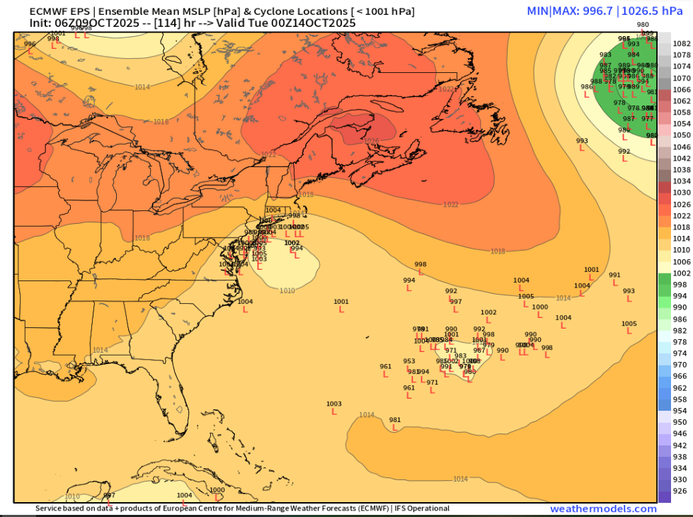
GFS could be a decent fall severe weather event with several tornadoes for western and central PA Sunday. Could see a solid line of storms move across here overnight. -
Spooky Season (October Disco Thread)
weatherwiz replied to Prismshine Productions's topic in New England
Could be interesting for a few hours early AM from just north of Los Angeles to just north of San Diego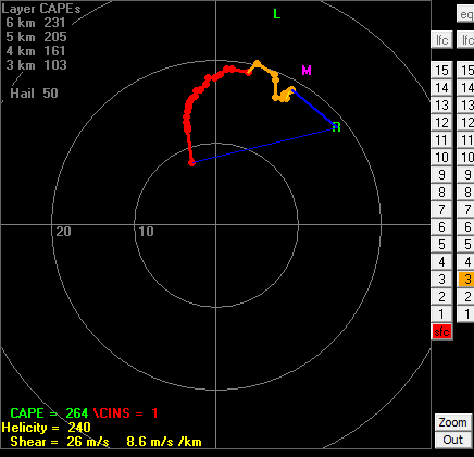
-
Small plane crashed on I95 in Dartmouth looks like around 9 AM
-
A widespread 5-6'' is going to be tough to come by I think because once occlusion occurs smaller-scale processes will then factor into where any heavier rain occurs, but a widespread 2-4" I think is very doable. I would not be surprised though to see some 6-8" amounts locally, particularly along the coast (but a bit inland). Probably see a secondary max too up north across east facing slopes
-
One big difference of note too is the timing. Window for some of the worst weather was more Sunday...Sunday night, maybe early Monday morning but the NAM would have this occur more during the day Monday. Not sure how much I buy into the NAM evolution though. Something to watch though is potential for elevated convection from southeast Connecticut, Rhode Island, and far eastern Mass. Elevated convection typically not favorable for producing wind, however, because of the strong llvl jet any elevated convection would surely help mix down some of that llvl jet. I could see gusts 55-65 mph along the immediate coast with sustained winds 25-35ish. It will be windy inland due to the pressure gradient but I don't think we'll see much in the way of higher wind gusts. Probably wouldn't even really see any gusts above 30-35.
-
The initial rainfall rates are going to be insane.
-
sometimes the consistency is a bit bizarre Fair point. Stupid
-
yeah it starts out warm core but then transitions quickly. probably why nhc doesn't have a little lemon but then again they do for that feature near the Azores and gave it an Invest
-
some strong members too. coastal flooding would be quite significant. probably numerous power outages too from Long Island...probably even coastal SNE.
-
Definitely a back off of these winds across southern CT (at least on the 6z GFS).
-
Stronger would actually be a negative for us I think. Stronger would yield quicker occlusion and alot of the processes would begin shutting down. Ultimately, would lead to less wind/rain, especially away from the coast.
-
Obviously still early but seems like the best spot to really mix down stronger winds will be far eastern Mass/Cape Cod (surprise, surprise) but GFS has more in the way of some convective precipitation out that way. But we'll mostly be focusing on pressure gradient for winds and that will help inland. Def becoming a bit concerned for some power outage potential. Gusts 50-60 generally not overly concerning but will be with leaves.
-
12z GFS continuing the theme...maybe even a bit more stout with wind potential, even inland to the Pike. edit: nvm...its status quo, maybe a tad weaker. I still had 6z up
-
Spooky Season (October Disco Thread)
weatherwiz replied to Prismshine Productions's topic in New England
looks like a nice little wind core aloft not far up -
Spooky Season (October Disco Thread)
weatherwiz replied to Prismshine Productions's topic in New England
and happy opening night for the Bruins hockey is back!!!! -
Spooky Season (October Disco Thread)
weatherwiz replied to Prismshine Productions's topic in New England
Wonder if we end up seeing any lightning/thunder from Guilford on east across the shoreline -
Spooky Season (October Disco Thread)
weatherwiz replied to Prismshine Productions's topic in New England
The rain is NUTS in Branford right now. Even a bit gusty -
Spooky Season (October Disco Thread)
weatherwiz replied to Prismshine Productions's topic in New England
definitely something to watch given trees are still quite full with leaves...but alot of leaves and trees will come down -
Spooky Season (October Disco Thread)
weatherwiz replied to Prismshine Productions's topic in New England
6z GFS has 57 knots for IJD and 54 knots HFD -
Spooky Season (October Disco Thread)
weatherwiz replied to Prismshine Productions's topic in New England
GFS not backing down. Would be one heck of a coastal flooding event too, particularly southwestern sound. -
Spooky Season (October Disco Thread)
weatherwiz replied to Prismshine Productions's topic in New England
Yup...not totally buying it. For whatever reason, the GFS has become pretty amped/phase happy in that range these last several years. It seems overall models have really struggled with northern stream evolutions and energy flowing within the stream. Maybe this is just in part due to enhanced flow but I hope there are some group of people out there doing some research into this. Whether its mostly background state or whether its with the physics/equations its odd and leading to so many hyped forecasts. -
Spooky Season (October Disco Thread)
weatherwiz replied to Prismshine Productions's topic in New England
Potentially, but verbatim that wouldn't be the case. The GFS takes its sweet time occluding the storm and we have a strong feed of warm/moist llvl air feeding into the region with the llvl warm front right along the coast and 700 warm front farther inland. That would be a recipe for some heavy rainfall across all of SNE...but as occlusion begins to occur we would start seeing the shield breakup a bit. -
Spooky Season (October Disco Thread)
weatherwiz replied to Prismshine Productions's topic in New England
Substantial differences with the northern energy lol and subsequently how the two interact. God I feel like we're dealing with winter .


