

weatherwiz
-
Posts
81,148 -
Joined
-
Last visited
Content Type
Profiles
Blogs
Forums
American Weather
Media Demo
Store
Gallery
Everything posted by weatherwiz
-

November 2025 general discussions and probable topic derailings ...
weatherwiz replied to Typhoon Tip's topic in New England
There are times when we can have a very solid idea looking 2-3-4 weeks out but I don't think this is one of those. There is just way too much going on and too many complexities, especially in the short term on how some of the subtle features evolve. Part of it too is we are still in the seasonal transition across the hemisphere and often times that can enhance the battles within the models. But I just want to get a favorable pattern moving through December and have cold air available. The brunt of the cold doesn't need to be over us and the cold doesn't necessarily need to be locked in. If we get a favorable storm track with cold air nearby...we will cash in (maybe not so much for coastal areas early on). Having cold air in place or even nearby means nothing if the storm track sucks. -
November 2025 general discussions and probable topic derailings ...
weatherwiz replied to Typhoon Tip's topic in New England
Been thinking that all day, its had that look -
November 2025 general discussions and probable topic derailings ...
weatherwiz replied to Typhoon Tip's topic in New England
yup...that could easily be overstated too. -
November 2025 general discussions and probable topic derailings ...
weatherwiz replied to Typhoon Tip's topic in New England
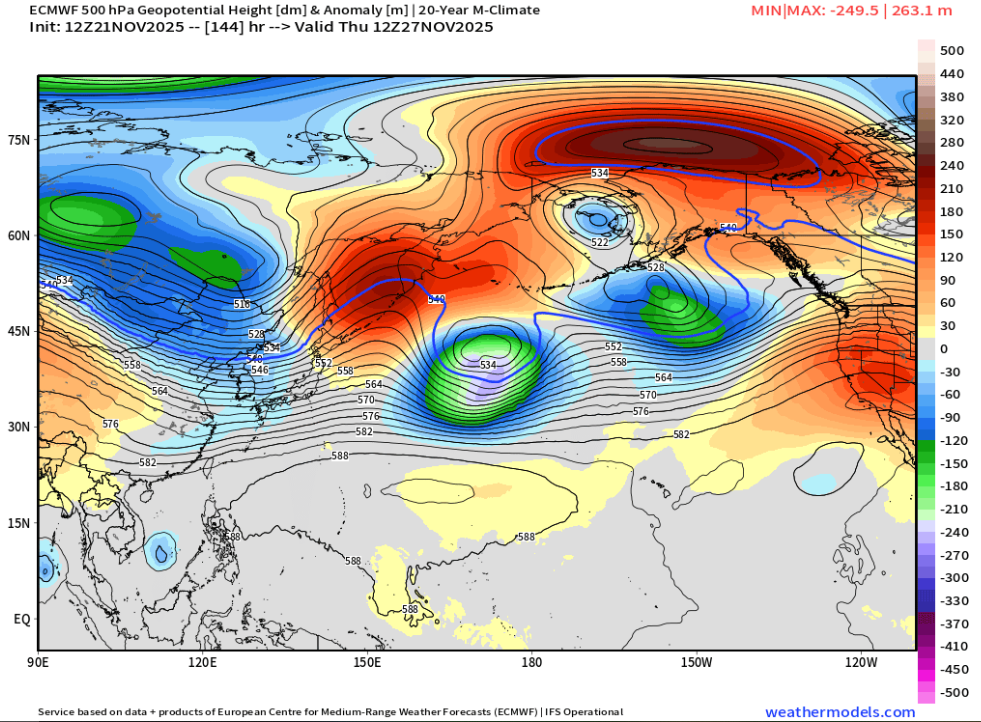
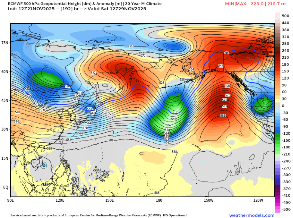
A big problem is even when we seem to get good PAC setups we can't seem to get a favorable orientation of the ridge so what looks to be a +PNA I don't think is a true +PNA and with the orientation of the ridging it just results in a dump of cold and a trough into the West and the result in pumping the heights up out east...big problem to have, especially when the SE ridge is still a prominent player. We would either need to get some blocking to flatten it a big or hope for an active northern stream and keep dampening the ridge a bit. But let's see what happens across eastern Russia and Asia over the week. Right now you have the PV on that side of the hemisphere and you have lobes breaking off it and ejecting across the NPAC within the East Asian jet stream. Late this weekend the Euro breaks off a piece and it looks like this piece is slated to be a big player in how the pattern evolves By Thursday you have a major ridge bridge to the north with the energy significantly stronger and forced to remain south with a lead wave ahead of it This really helps to pump up a ridge downstream and helps aid in the amplification of that lead shortwave across the Northwest and a subsequent significant increase in the heights out in the East. My point in all this is just too illustrate how fickle guidance be be in the evolution of a pattern just from one piece. If such a piece never breaks off or is not as strong as advertised...that completely changes the game. The northern hemispheric flow is way too chaotic right now...its like a nascar track with too many drivers...so many drivers trying to set their lane and pace the field but everyone is competing to do the same thing. This makes it nearly impossible to have any idea of what to expect, until you start to see how these players in the 48-72 hour forecast actually look at 48-72 hours.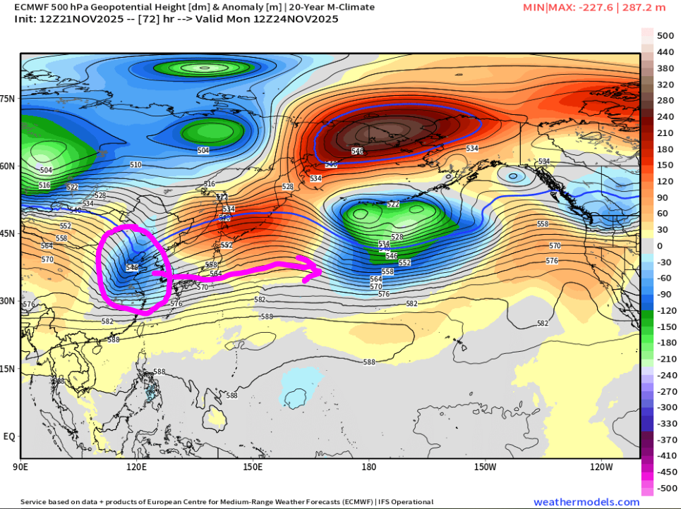
-
November 2025 general discussions and probable topic derailings ...
weatherwiz replied to Typhoon Tip's topic in New England
I could see NNE doing really well moving through Dec. But I'm holding out alot of hope on another SSW occurring. When you're looking for something to shake things up...that is something that can do it. Seeing how the stratosphere has evolved so far and some of the forecasts moving through the next few weeks...I think is a great signal. This opens the door for January and February. If December sucks then so be it...but if it does suck we better be seeing things starting to change...and I don't mean "10 days out stuff"...like actually physically ongoing changes -
November 2025 general discussions and probable topic derailings ...
weatherwiz replied to Typhoon Tip's topic in New England
Pattern looks active but need to get the flow to kind of slow down a bit...but been waiting on that for like 8 years -
November 2025 general discussions and probable topic derailings ...
weatherwiz replied to Typhoon Tip's topic in New England
The GFS could be ran on Nov 29 with all the input variables of the 27th and still not get how the 27th unfolded correct -
Voted for 6th. Have a groomers appointment for the dog at 11:00 AM but that won't affect being able to go. I'm assuming we'd be meeting up somewhere between 1:00-2:00?
-
November 2025 general discussions and probable topic derailings ...
weatherwiz replied to Typhoon Tip's topic in New England
Yes, although now its a bit more difficult since last summer our dog had a severe spinal stroke which has left very little mobility/control of his back legs so his playing days are over. But the hope from the neurologist was over time he would get back to 100% but it never happened. We did a third and final MRI back at the end of the summer and it revealed the part of his spine that had the stroke (it was his second one) is slowly being replaced by fluid, so we went the wheel chair route and he loves it...can go on walks again! But being able to go on walks again is phenomenal. -
November 2025 general discussions and probable topic derailings ...
weatherwiz replied to Typhoon Tip's topic in New England
Snow makes the early sunsets much more tolerable for sure. There is nothing like it being dark out at 4:30 with heavy snow falling and just the quietness outside with nobody driving. One thing that doesn't bother me either is the stars. Last night I was outside with the dog at like 6:15 and the sky was perfectly clear with plenty of stars overhead and the stars were bright and vibrant. I also did get a little sad though thinking back to the summer when it was 6:15 and just sitting outside drinking a beer. I think the key though with early sunsets and the seasonal depression stuff is just trying to stay busy...which is hard when you're cooped up inside because there isn't much to do outside. Early sunsets never really used to bother me until maybe the last 4-5 years and I've thought why that is...figured maybe just getting older but then it dawned on me. I used to be very active doing stuff...had season tickets to the Wolf Pack and would go to road games that they would play locally sometimes there could be like 3 games a week. Plus school kept me busy...then I finished school, and it was just work and being lazy. But being back in school + work...don't have time to notice it being dark -
November 2025 general discussions and probable topic derailings ...
weatherwiz replied to Typhoon Tip's topic in New England
I feel like Detroit is just in a shit area for snow. Too far removed from Lake Michigan to get the good LES and generally too far northwest from low pressures that strengthen within the OV and moving out way. And with cutters...they are probably either just too far west for the goods or on the extreme western cutters for of a mix. Its probably clippers mostly for them? -
November 2025 general discussions and probable topic derailings ...
weatherwiz replied to Typhoon Tip's topic in New England
even mesos are a mess for us, yes but I am looking at more of the region as a whole (including just to our south. I would have to think any north guidance with the heavier axis is wrong but we do get some increasing diffluence aloft late with PVA so we may see showers blossom (just not heavy rain...maybe coast gets heavier rain). -
November 2025 general discussions and probable topic derailings ...
weatherwiz replied to Typhoon Tip's topic in New England
What an absolutely colossal joke guidance is with tomorrow night. Who event wants to forecast precipitation events 4-5 days out? It's been absolutely terrible. I can only wonder how many storms we'll see on guidance 4-5 days out and the snow maps of 8...10...12+ inches start flying out only for significant reductions inside of 48 hours. Or who knows...maybe we'll get some in the other direction where it looks like crap and then we're forecasting 6-10" all of a sudden -
November 2025 general discussions and probable topic derailings ...
weatherwiz replied to Typhoon Tip's topic in New England
There was alot of ice in my freezer this morning too, more than usual. that's because I turned on the ice maker -
November 2025 general discussions and probable topic derailings ...
weatherwiz replied to Typhoon Tip's topic in New England
Who uses an umbrella when its windy? -
6th (I think) or 20th work for me. Let's make this happen
-
November 2025 general discussions and probable topic derailings ...
weatherwiz replied to Typhoon Tip's topic in New England
Can't even get good agreement on models on how tomorrow/tomorrow night evolve -
November 2025 general discussions and probable topic derailings ...
weatherwiz replied to Typhoon Tip's topic in New England
The sky is so clear. Couldn’t get this for the big aurora show??? -
November 2025 general discussions and probable topic derailings ...
weatherwiz replied to Typhoon Tip's topic in New England
If we keep pushing back I can have fun with the running joke... pattern is changing by December 1...no December 10...christmas...New Years, definitely mid January, Feb will be big...hello spring! This is a great visual for context, thanks! MJO could be a factor too...just looked at euro/gfs forecasts. Both have a robust wave propagating into 6/7. Obviously MJO forecasting is extremely iffy at this range, but when you look at the GFS/euro evolution around/shortly after Thanksgiving...its a pretty damn close match to what you would expect for a transition from 6 to 7. So if the MJO signal ends up being overplayed...you may see significant changes to guidance for this period. -
November 2025 general discussions and probable topic derailings ...
weatherwiz replied to Typhoon Tip's topic in New England
So essentially, (let's say it is occurring now or in the beginning phases), we probably wouldn't see that troposphere respond probably until late December? -
November 2025 general discussions and probable topic derailings ...
weatherwiz replied to Typhoon Tip's topic in New England
I thought there was a weak signal up around 10 hpa which strengthened down around 30 hpa and especially 50 hpa? But I may have diagnosed incorrectly -
November 2025 general discussions and probable topic derailings ...
weatherwiz replied to Typhoon Tip's topic in New England
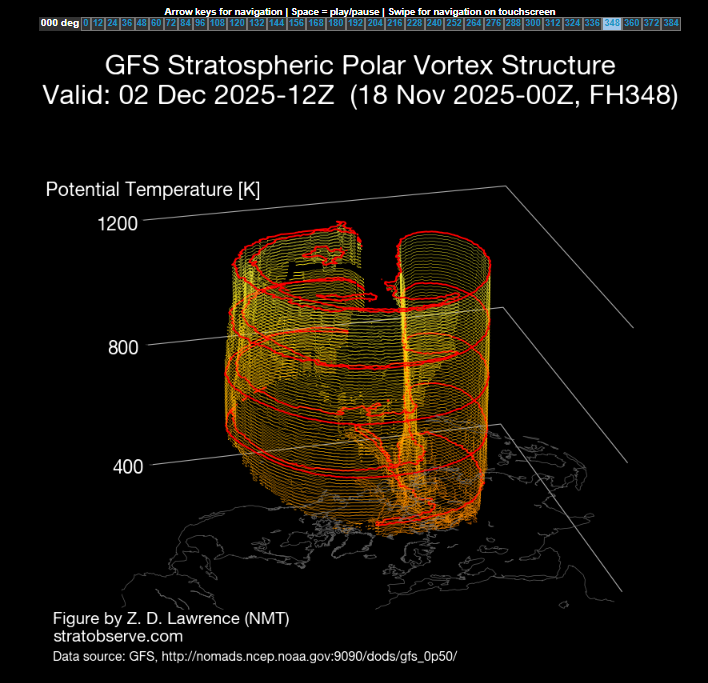
We definitely want to watch the progression of the progression of the stratosphere too. The good news is, we already have a warming event ongoing and across the Canadian Arctic If you were to follow this progression on Dr. Lawrence's site, its a longer duration event too with the peak occurring somewhere in the 300 hr time frame This is important (when the peak occurs) because this would likely result in a PV split, which begins to occur towards the end of the run Getting a PV split will be critical because the main PV looks like it could end up over Europe, but if it splits, then we could get PV displacement onto our side of the hemisphere.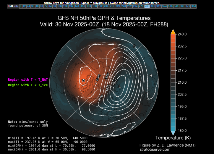
-
November 2025 general discussions and probable topic derailings ...
weatherwiz replied to Typhoon Tip's topic in New England
Let's really, really hope the PAC plays out and evolves like that. But even if it doesn't...if it can at least evolve to a degree where we can continue to further develop that later in the month...that would be a big change. I also wouldn't mind maintaining a stronger SE ridge...coastal peeps may not want that and of course that could be playing Russian Roulette but that would at least help with an active storm track with ejecting shortwaves from the southwest...then we just hope for a perfect trough axis to our west. -
November 2025 general discussions and probable topic derailings ...
weatherwiz replied to Typhoon Tip's topic in New England
Yup...we briefly get a shot of cold air behind the post Thanksgiving time frame and then pup heights right back up ahead of the next system. But hopefully we really do start changing things after that front later in the first week of December. Praying we really do start building heights and ridging into the West so we stop with this building heights ahead of systems, then getting a shot of cold air, only to build heights up as the next trough digging into the west translates east. If we can sustained riding in the west...we won't have to completely worry about that...especially if we can then get some Arctic support on our side. -
November 2025 general discussions and probable topic derailings ...
weatherwiz replied to Typhoon Tip's topic in New England
Euro with the 582dm heights into WV/MD and 576 to the NY/PA borer to kick off December. That would be some impressive warmth ahead of the cold front into the mi-Atlantic and parts of the Northeast (unless there happens to be any wedging).


