weatherwiz
-
Posts
79,817 -
Joined
-
Last visited
Content Type
Profiles
Blogs
Forums
American Weather
Media Demo
Store
Gallery
Everything posted by weatherwiz
-

July 2025 Obs/Disco ... possible historic month for heat
weatherwiz replied to Typhoon Tip's topic in New England
Gotta say…Margrave or whatever his name is is right about the pool stuff. Took a dip in the pool and surprised how warm even the bottom water is. I’ve submerged my body in the water and when I pop out…that evaporative cooling with the lower dews really yields a quick chill. -
July 2025 Obs/Disco ... possible historic month for heat
weatherwiz replied to Typhoon Tip's topic in New England
that may actually provide focus for thunderstorms tomorrow...guess it will be a S coast day for some storms -
July 2025 Obs/Disco ... possible historic month for heat
weatherwiz replied to Typhoon Tip's topic in New England
whoops...I misspoke. NBM for the win at EWR. GFS nailed BOS. -
July 2025 Obs/Disco ... possible historic month for heat
weatherwiz replied to Typhoon Tip's topic in New England
NBM FTW -
July 2025 Obs/Disco ... possible historic month for heat
weatherwiz replied to Typhoon Tip's topic in New England
Even this cute little mouse is enjoying the heat
-
July 2025 Obs/Disco ... possible historic month for heat
weatherwiz replied to Typhoon Tip's topic in New England
up, up, and away -
July 2025 Obs/Disco ... possible historic month for heat
weatherwiz replied to Typhoon Tip's topic in New England
As we compare the next several years to the 1991-2020 climate regime, it will be more difficult to notice greater departures unless we reach the next level of heat...which would be widespread lower 100's and occurring multiple times over the course of the summer. It isn't impossible that will happen but a ton would have to go right IMO to happen. What we're most likely going to continue doing is seeing consistent and a longer seasonal duration of dewpoints well into the 70's and continuing the uphill climb of overnight lows. -
July 2025 Obs/Disco ... possible historic month for heat
weatherwiz replied to Typhoon Tip's topic in New England
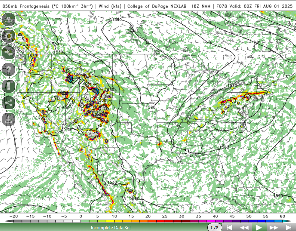
Well I shouldn't say its too far north but I think its intensity by the NAM is being way overplayed and its resulting in dynamics going wild. -
July 2025 Obs/Disco ... possible historic month for heat
weatherwiz replied to Typhoon Tip's topic in New England
Can essentially nowcast this tonight and early tomorrow morning by watching how the convection develops and evolves centered around Iowa. Too me I think the 12z NAM is wayyy over aggressive with the northward extent of that convection and how intense it is and its going bonkers with the dynamics. -
July 2025 Obs/Disco ... possible historic month for heat
weatherwiz replied to Typhoon Tip's topic in New England
Yeah whether this stalls or not is going to be a huge key. The front does become parallel to the upper flow which would be an indication that it will stall...just a matter of where. -
July 2025 Obs/Disco ... possible historic month for heat
weatherwiz replied to Typhoon Tip's topic in New England
What a difference between the 6z/12z NAM in how it handles the convective development and evolution tonight/tomorrow -
July 2025 Obs/Disco ... possible historic month for heat
weatherwiz replied to Typhoon Tip's topic in New England
I don't think we're going to see much, if any, convection down this way tomorrow. Looks like we're pretty capped and the LFC is pretty high and separated from the LCL. Probably just see stuff develop across the high terrain of PA/NY which slides east but kind of dissipates. Debating whether we may have a chance to see a few storms pop during the evening but forcing looks pretty limited. -
July 2025 Obs/Disco ... possible historic month for heat
weatherwiz replied to Typhoon Tip's topic in New England
Also looks good for transient supercells across Maine tomorrow...maybe even a little localized enhanced tornado potential towards the coast and around Portland. -
July 2025 Obs/Disco ... possible historic month for heat
weatherwiz replied to Typhoon Tip's topic in New England
Leaning in the direction of lower rainfall amounts for end of week versus anything over the top. The bulk of the convection that develops tonight and Wednesday from SD/NE/MA/IA is going to end up riding the instability boundary and trucking into the mid-Atlantic where the greatest instability is and that is going to rob a ton of available moisture. We'll likely see downpours and thunderstorms ahead of the front Thursday but widespread significant rainfall totals I don't think will be happening. Just a typical fropa with downpours and thunderstorms ahead of it. -
July 2025 Obs/Disco ... possible historic month for heat
weatherwiz replied to Typhoon Tip's topic in New England
Absolutely beautiful outside. Already feel the process of my body beginning to produce sweat. There is nothing like feeling the hot, strong sun beat down on you and the tingles you get when the sweat producing process commences. I mean this is gold, everyone loves it. The birds are happy, praying mantis are happy, people have smiles on their faces. Feel it, embrace it, love it. -
July 2025 Obs/Disco ... possible historic month for heat
weatherwiz replied to Typhoon Tip's topic in New England
If this is the direction we're going to head then there is going to be some serious issues somewhere for sure. Want to wait another day or so before really getting concerned and crazy but this is impressive for summer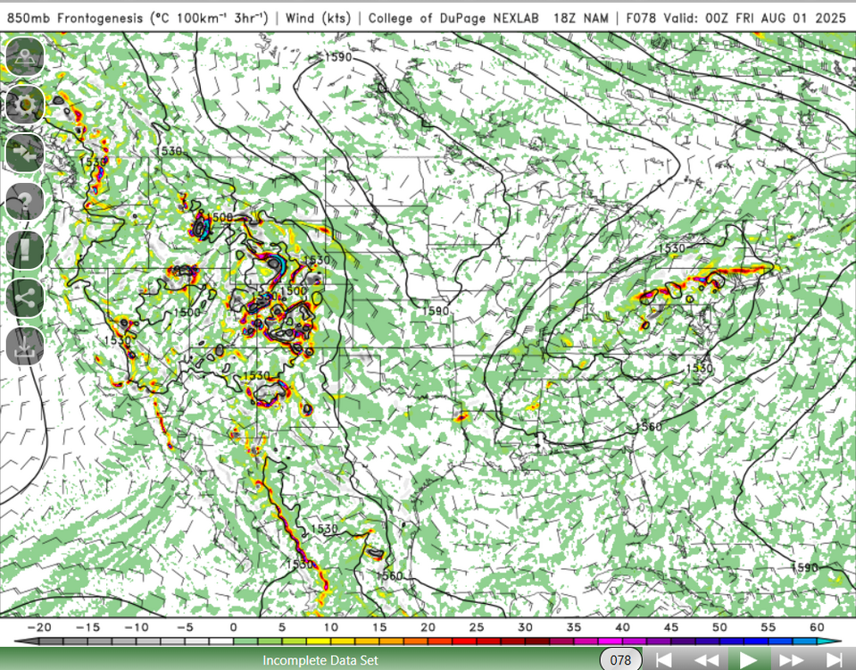
-
July 2025 Obs/Disco ... possible historic month for heat
weatherwiz replied to Typhoon Tip's topic in New England
It certainly seems like it. Looking at the NAM though you could probably also argue that 925/850 low could be overstated...even maybe on euro a bit but the weathermodel graphics are awful. I could see this going either way right now but it def has to be watched. -
July 2025 Obs/Disco ... possible historic month for heat
weatherwiz replied to Typhoon Tip's topic in New England
That is one hell of a thermal gradient though for the warm season across the region. That would be some hefty lift across the region along the warm front with some decent elevated CAPE. Would have to wonder though if convection across the mid-Atlantic robs any moisture...convection could be robust there. This is interesting and intriguing for sure. -
July 2025 Obs/Disco ... possible historic month for heat
weatherwiz replied to Typhoon Tip's topic in New England
The front though does look like it would become parallel to the upper-level flow. There are some signals for a significant rainfall event but some of these signals could be overstated too. Have to see where we stand in the next 1-2 days -
July 2025 Obs/Disco ... possible historic month for heat
weatherwiz replied to Typhoon Tip's topic in New England
The NAM/Euro may have a bit of convective feedback going on -
July 2025 Obs/Disco ... possible historic month for heat
weatherwiz replied to Typhoon Tip's topic in New England
Oh man look at this from the 12z NAM for DSM this evening. Those CAPE numbers are ridiculous. 1450 Hail CAPE...WOOOOOOWWWWWW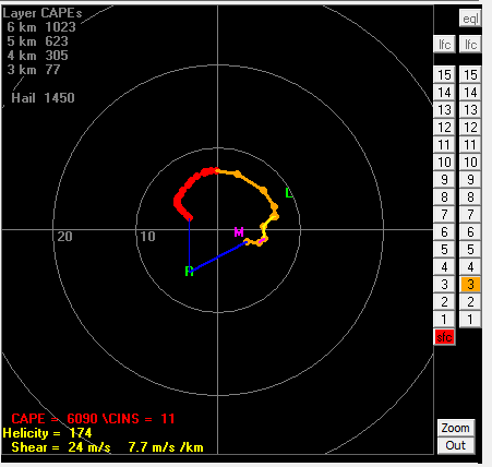
-
July 2025 Obs/Disco ... possible historic month for heat
weatherwiz replied to Typhoon Tip's topic in New England
we should bake, especially with the westerly sfc flow and should have ample sun -
July 2025 Obs/Disco ... possible historic month for heat
weatherwiz replied to Typhoon Tip's topic in New England
CAPE is great but means nothing without a robust enough trigger! Unfortunately, the largest CAPE days generally occur when there is a lack of forcing/trigger. CAPE values that high aren't actually uncommon in those parts but it gains more attention when you have a forcing mechanism. -
July 2025 Obs/Disco ... possible historic month for heat
weatherwiz replied to Typhoon Tip's topic in New England
Thursday though could feature potential for a few tornadoes across southern CT/Long Island/RI/Cape Cod -
July 2025 Obs/Disco ... possible historic month for heat
weatherwiz replied to Typhoon Tip's topic in New England
That NAM has a narrow corridor of 5000-6000 J of MLCape with DCAPE values ~1500+ J....that's absurd. There's going to be some significant wind damage