

weatherwiz
-
Posts
81,132 -
Joined
-
Last visited
Content Type
Profiles
Blogs
Forums
American Weather
Media Demo
Store
Gallery
Everything posted by weatherwiz
-

First Legit Storm Potential of the Season Upon Us
weatherwiz replied to 40/70 Benchmark's topic in New England
Very well could be too expansive. -
First Legit Storm Potential of the Season Upon Us
weatherwiz replied to 40/70 Benchmark's topic in New England
It will eventually hit one after 1000 tries and then everyone is going to get sucked into it because it finally got a hit and ignore the other 999 misses -
First Legit Storm Potential of the Season Upon Us
weatherwiz replied to 40/70 Benchmark's topic in New England
The AIGFS doesn't seem too drastically different from the 12z OP run yesterday in terms of the H5 evolution, both srn stream and nrn stream. -
First Legit Storm Potential of the Season Upon Us
weatherwiz replied to 40/70 Benchmark's topic in New England
nahhh that would be more if we had model consensus for a big hit now, only to see the rug get pulled out from under us as we got closer -
First Legit Storm Potential of the Season Upon Us
weatherwiz replied to 40/70 Benchmark's topic in New England
Neither did Bears fans entering the 4th quarter. Let's Chicago Bears this thing -
First Legit Storm Potential of the Season Upon Us
weatherwiz replied to 40/70 Benchmark's topic in New England
He probably prefers to keep his sanity -
First Legit Storm Potential of the Season Upon Us
weatherwiz replied to 40/70 Benchmark's topic in New England
I enjoy his tweets. He definitely does not hype and is pretty straightforward. I really enjoy his posts during convective events -
First Legit Storm Potential of the Season Upon Us
weatherwiz replied to 40/70 Benchmark's topic in New England
Yeah I don't think there is any convective feedback issue going on here...hardly any, if any, convection with this anyways in the Southeast -
First Legit Storm Potential of the Season Upon Us
weatherwiz replied to 40/70 Benchmark's topic in New England
Agreed...I think it's going to be until Friday or Saturday before we have a true gasp on the 500mb evolution. -
January 2026 regional war/obs/disco thread
weatherwiz replied to Baroclinic Zone's topic in New England
Sick One of my classes this semester, Advanced Forecasting Techniques will cover winter weather forecasting including long range/seasonal forecasting and teleconnections -
First Legit Storm Potential of the Season Upon Us
weatherwiz replied to 40/70 Benchmark's topic in New England
Hopefully Tyler Loop isn't kicking -
First Legit Storm Potential of the Season Upon Us
weatherwiz replied to 40/70 Benchmark's topic in New England
I think at this point we would need to see some sizable adjustments from the Euro (which I don't see happening) with the 0z run tonight if we want to talk about potential for widespread warning criteria. I guess we wait on the EPS now -
First Legit Storm Potential of the Season Upon Us
weatherwiz replied to 40/70 Benchmark's topic in New England
It was looking *slightly* promising between 90-96 hours then went to hell -
First Legit Storm Potential of the Season Upon Us
weatherwiz replied to 40/70 Benchmark's topic in New England
That n/s is def more of a kicker on the euro versus gfs. big differences too with that srn stream shortwave and how it evolves across the southeast. Was hoping to see something more positive here -
First Legit Storm Potential of the Season Upon Us
weatherwiz replied to 40/70 Benchmark's topic in New England
Yeah I think at the end of the day the 12z GFS OP is probably towards the outlier side of what would ultimately happen. I'm just hoping for slight improvements from the euro this run from 0z/6z....all we can ask for right now. -
January 2026 regional war/obs/disco thread
weatherwiz replied to Baroclinic Zone's topic in New England
Yup! -
January 2026 regional war/obs/disco thread
weatherwiz replied to Baroclinic Zone's topic in New England
I am going to be more interested in hoe euro looks with the H5 evolution moreso than what it does at the sfc with SLP development. Just want to see some ticks in this regard (H5) towards the GFS. But the euro really isn't far off so it's very plausible. -
January 2026 regional war/obs/disco thread
weatherwiz replied to Baroclinic Zone's topic in New England
As the GFS was out to Sunday I was wondering if that energy diving down the Plains was going to end up screwing things up but ultimately it ended up feeding into our vort and helping to go boom. -
January 2026 regional war/obs/disco thread
weatherwiz replied to Baroclinic Zone's topic in New England
Well the GFS illustrates pretty well what we need to see happen to get such a solution. Even the euro isn't too far off but it just goes to show how sensitive setups like this are. -
January 2026 regional war/obs/disco thread
weatherwiz replied to Baroclinic Zone's topic in New England
Haven't seen a 500 evolution like this in a while it feels like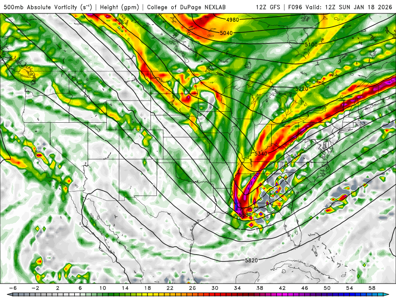
-
January 2026 regional war/obs/disco thread
weatherwiz replied to Baroclinic Zone's topic in New England
Much better digging by 12z Sunday and it looks lie the trough is becoming neutrally tilted as its crossing AL/GA....I love me some of that look. -
January 2026 regional war/obs/disco thread
weatherwiz replied to Baroclinic Zone's topic in New England
12z GFS looking like a few spots may be able to grab a few inches Saturday too. That is some macho vort -
January 2026 regional war/obs/disco thread
weatherwiz replied to Baroclinic Zone's topic in New England
When I first became introduced to forecast models and I'd see those "white blob" like -30F 850 temps I think it was from Plymouth models...I used to open my freezer and suck in the air as hard as I could to prepare for breathing in that cold -
January 2026 regional war/obs/disco thread
weatherwiz replied to Baroclinic Zone's topic in New England
BOS perhaps gets near 50F with 40's elsewhere...but temperatures start dropping west-to-east through the afternoon...probably see squalls along the leading edge of the colder air -
January 2026 regional war/obs/disco thread
weatherwiz replied to Baroclinic Zone's topic in New England
could see a couple bands of snow squalls moving across the region tomorrow


