weatherwiz
-
Posts
81,132 -
Joined
-
Last visited
Content Type
Profiles
Blogs
Forums
American Weather
Media Demo
Store
Gallery
Everything posted by weatherwiz
-

January 2026 regional war/obs/disco thread
weatherwiz replied to Baroclinic Zone's topic in New England
just based on that, the concept may be more related to placement or displacement of the jet versus the actually speed...though speed probably more of a factor in relation to jet streaks versus the jet as a whole. -
January 2026 regional war/obs/disco thread
weatherwiz replied to Baroclinic Zone's topic in New England
Agreed 100%. I think its an interesting theory but needs alot more work. I do recall Tip having posting some studies before -
January 2026 regional war/obs/disco thread
weatherwiz replied to Baroclinic Zone's topic in New England
I'm beginning to wonder if the fast flow stuff with respect to phasing (or lack thereof I guess) is kind of voodoo. I've been thinking more of this lately since the exchange Ray and I had a few weeks back. I mean, first off, how are we defining or characterizing "fast flow"? I would guess a certain SD above the norm? I mean during the cold season the jet stream is strongest, so its already naturally fast. -
January 2026 regional war/obs/disco thread
weatherwiz replied to Baroclinic Zone's topic in New England
I’m just looking at the pattern and how shortwaves are moving. I don’t think it will be bone dry…we’ll have some chances to work with -
January 2026 regional war/obs/disco thread
weatherwiz replied to Baroclinic Zone's topic in New England
12z was active…it just wasn’t want people wanted to see lol. But the upcoming stretch should be more on the active side -
January 2026 regional war/obs/disco thread
weatherwiz replied to Baroclinic Zone's topic in New England
Active times coming up. Details TBD -
January 2026 regional war/obs/disco thread
weatherwiz replied to Baroclinic Zone's topic in New England
That’s like saying the Giants are better than the Jets -
January 2026 regional war/obs/disco thread
weatherwiz replied to Baroclinic Zone's topic in New England
I’ve yet to ever even look at it -
January 2026 regional war/obs/disco thread
weatherwiz replied to Baroclinic Zone's topic in New England
That would be nice. Certainly enough time to where that is plausible...that could be wishful thinking it just goes to show it wouldn't take much. That shortwave digging into the northern Plains there may be inhibiting such a scenario? -
January 2026 regional war/obs/disco thread
weatherwiz replied to Baroclinic Zone's topic in New England
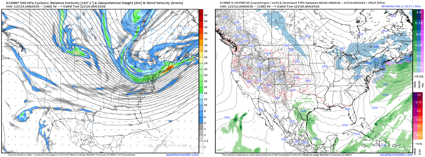
Certainly something to watch, obviously verbatim as Will said too late for most but that is a nice stream of vorticity so just have to hope we can get a vort max to kind of take the lead early enough. Curious to see what the EPS will look like
-
January 2026 regional war/obs/disco thread
weatherwiz replied to Baroclinic Zone's topic in New England
May need the tanning oil too -
January 2026 regional war/obs/disco thread
weatherwiz replied to Baroclinic Zone's topic in New England
If they are serious about improving from last year and beefing up the offense they really have no choice but to do so. I'm sure Breslow is refining his code to find out which trades he should seek -
January 2026 regional war/obs/disco thread
weatherwiz replied to Baroclinic Zone's topic in New England
There is a better chance I have another very close encounter with a gustnado than the Red Sox doing anything major on the offensive addition front -
January 2026 regional war/obs/disco thread
weatherwiz replied to Baroclinic Zone's topic in New England
I wouldn't totally throw in the towel on the 20th yet...it's still a week out and we've seen some swings with the evolution of that shortwave digging in around that period. It's really not that far off from producing something. I would give this another 3 days or so before totally writing it off. And beyond that, with that Arctic front as advertised...there will almost certainly be some significant winter weather produced by that...we just have to hope we end up in the spot. There is no way to definitively lean one way or another right now so all we can do is assess -
January 2026 regional war/obs/disco thread
weatherwiz replied to Baroclinic Zone's topic in New England
I kind of figured you were haha. It was pretty entertaining though watching that blow up for a bit lol -
January 2026 regional war/obs/disco thread
weatherwiz replied to Baroclinic Zone's topic in New England
If the pattern sets up right and things align correctly, we may not have to worry about melting anything within a few days but we'll have to see what happens moving through the first week of February. A bit more in the way of uncertainty in this respect. At least the incoming cold is setting the stage, now we just have to hope the show delivers. -
January 2026 regional war/obs/disco thread
weatherwiz replied to Baroclinic Zone's topic in New England
I didn't really think it was that big of a deal I said final few weeks of the month..so then just replace few with couple. It's not like I said it with one full week left to go. -
January 2026 regional war/obs/disco thread
weatherwiz replied to Baroclinic Zone's topic in New England
nahhh we all should be cautiously optimistic moving through next week and the following week -
January 2026 regional war/obs/disco thread
weatherwiz replied to Baroclinic Zone's topic in New England
several (I) usually refers to more than 5. Couple/few I always thought were about the same in terms of a numerical reference -
January 2026 regional war/obs/disco thread
weatherwiz replied to Baroclinic Zone's topic in New England
A month has 4 weeks. A few is 2...so few = 2 weeks -
January 2026 regional war/obs/disco thread
weatherwiz replied to Baroclinic Zone's topic in New England
As long as the extended range looks active with hits that's all we can ask for right now. The extended shows plenty of cold around and looks active...can't ask for anything else really. Obviously we're going to want to see this continuing as we get closer but the look is hopeful. -
Pretty much every thread turns into a whiner thread these days Luck has got to change eventually
-
That's what I'm mostly referring to though...is the more extreme side of the cold. If you're outside and even if its into the lower 20's and your dressed for it and active, you'll be able to tolerate it for sure. I've never skied but I can presume that if its in the teens or maybe even single digits, with all the equipment plus the body working...you'll build up a sweat.
-
Oh yes...I mean if you're outside being active and doing stuff that certainly helps. I mean before I started driving and I had to either take the bus everywhere or walk (used to walk 2+ miles to work and back when busses didn't operate) I would get warm...even if it was in the teens. But nobody is going outside when its 15F out and going, "ahhh this is such a great day". Even those saying they like the cold or don't mind it...sit outside in a lawn chair for 3-4 hours (even if dressed like an eskimo) and tell me its enjoyable or tolerable or likable
-
January 2026 regional war/obs/disco thread
weatherwiz replied to Baroclinic Zone's topic in New England
The final few weeks of the month are going to be interesting...just have to hope the storm track sets up and work in our favor. But at lease these two look like a decent bet 1) Active storm track 2) Plenty of cold air around Storm track is going to be the critical component here because despite the cold around things could evolve to where we predominately see cutters. We can hope for a more negative NAO with favorable structure orientation but there is a quite a bit of spread in the direction of the NAO.