

weatherwiz
-
Posts
79,813 -
Joined
-
Last visited
Content Type
Profiles
Blogs
Forums
American Weather
Media Demo
Store
Gallery
Everything posted by weatherwiz
-

November 2025 general discussions and probable topic derailings ...
weatherwiz replied to Typhoon Tip's topic in New England
That missing snowfall data pisses me off. I always forget what happened...it had to do with the switching from something to something but 1995-1996 was like 115.2" and I'm pretty sure 2002-20023 was over 80" or maybe 90" and I think is second highest on record for BDL..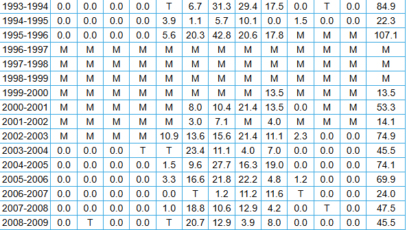
-
November 2025 general discussions and probable topic derailings ...
weatherwiz replied to Typhoon Tip's topic in New England
maybe it was 03-04 and 04-05...or maybe it was like 02-03 good, 03-04 sucked, then 04-05 was great. Can't find my notebook. Guess I'll look online but the handling of the snowfall and tornado databases frustrates the hell out of me. -
November 2025 general discussions and probable topic derailings ...
weatherwiz replied to Typhoon Tip's topic in New England
Wasn't there a back-to-back period there where BDL put up like 90" then 70"+? -
November 2025 general discussions and probable topic derailings ...
weatherwiz replied to Typhoon Tip's topic in New England
Wasn't 2002-2003 and 2003-2004 like a wire-to-wire winter? -
November 2025 general discussions and probable topic derailings ...
weatherwiz replied to Typhoon Tip's topic in New England
I would bank on this. Confluence has been superior more often that not the last several years across southeast Canada. -
November 2025 general discussions and probable topic derailings ...
weatherwiz replied to Typhoon Tip's topic in New England
It's not worry, it's analysis, assessment, and questioning. There is way too much emphasis and focus on extended range EPS signals and not enough focusing on real time observations (current state/pattern) and evolution of the short term pattern to look for those signals which may begin driving the pattern. Patterns just don't magically change and don't magically change. There are typically day-to-day nuisances which will determine how the pattern unfolds and behaves. For example, let's say forecast models were showing a drastic change say D6 or D7 (even D5)...we would be able to see in the next day or two those pieces which will be responsible for the change and determine in the short term the validity of this change instead of chasing D10 EPS means. -
November 2025 general discussions and probable topic derailings ...
weatherwiz replied to Typhoon Tip's topic in New England
Overall (at least 12z) the not much difference between the Euro/GFS ensembles outside of strength of key features and placement of the main anomaly centers but that is a warm look overall but can't dismiss any wedge potential like Scott said. But I don't really like the way the pattern is configured overall to elicit some big magical changes going through the first week of December. I think we'll certainly see some colder periods, like we've seen this month, but they are brief and more transient. There are multiple things we're fighting 1) Persistent evolution of lower heights and deep troughing across the West 2) A stout subtropical ridge which is flexed into the Southeast as those troughs amplify and dig into the west 3) Even with a -NAO look at times, which helps to bring in that colder air (for a brief period) you always have to watch for connecting heights across the east. Maybe things break down a bit moving through the first week of December but we're going to want to see something in real time (like in 7-10 days) that is in place that will not trigger it...not the it will change because it looks better at D10 ordeal -
November 2025 general discussions and probable topic derailings ...
weatherwiz replied to Typhoon Tip's topic in New England
Have to watch for for what looks to be a 50/50 low which really works to compress the heights across the Northeast. Interesting to see how that plays out. The overall structure of the pattern though does favor at least near average temperatures but more than likely above. This feature could mute that, for a brief period anyway. There is going to be a lot of moving pieces (fast moving weak systems) embedded in the flow so like Will said...NNE might be able to cash in on something -
November 2025 general discussions and probable topic derailings ...
weatherwiz replied to Typhoon Tip's topic in New England
I know our climo is mid January to mid February for our snows, but I really hate having to rely on that period to start playing "catchup". But this is more likely a product of the last several winters. But I'm so sick of this rut...we start super slow, then things start looking better towards peak, and then it's just a constant chasing of D10 pattern changes through peak climo, and then all of a sudden D10-15 all of a sudden is getting into and going through March. Then we get the best patterns in March when everyone is ready for warmer weather but end up with 35F rain storms while up north and higher elevations cash in -
November 2025 general discussions and probable topic derailings ...
weatherwiz replied to Typhoon Tip's topic in New England
No disagreement there. My number one overall concern is just regarding the flow...it just remains overly strong and as long as that continues we're just going to have to really rely on threading the needle alot more and end up dealing with more "near misses" than not. -
November 2025 general discussions and probable topic derailings ...
weatherwiz replied to Typhoon Tip's topic in New England
I always thought the bias of the models mishandling of EPO at times had a greater impact regarding the dump of cold air just east of the Rockies. A -EPO is great in the sense that it delivers the Arctic air into the lower 48's but we also need a few other things align to get that to propagate east (without moderating). The overall structure of things seem like any colder shots here would be brief (though we probably still end up a bit below average). -
November 2025 general discussions and probable topic derailings ...
weatherwiz replied to Typhoon Tip's topic in New England
Woke up to the first coating of snow on the season this morning! Coating may be too strong of a word though...maybe a sprinkle of snow...like loading mashed potatoes up with salt -
November 2025 general discussions and probable topic derailings ...
weatherwiz replied to Typhoon Tip's topic in New England
Much of this week is actually even a bit below average, except probably towards the end of the week ahead of the next system. -
Winter 2025-2026 Offers Return to Normalcy
weatherwiz replied to 40/70 Benchmark's topic in New England
I have to finish reading your outlook Ray (I've gotten through your MJO analysis) but I don't think it can be stated enough how phenomenal of a writer you are, your wealth of knowledge, and how easily you're able to explain things. -
November 2025 general discussions and probable topic derailings ...
weatherwiz replied to Typhoon Tip's topic in New England
This wind is nuts. Was going to take a little break from class work and clean the gutters but I don't think I'll be going on a ladder in this -
November 2025 general discussions and probable topic derailings ...
weatherwiz replied to Typhoon Tip's topic in New England
At some point soon it will change and we will get crushed. -
November 2025 general discussions and probable topic derailings ...
weatherwiz replied to Typhoon Tip's topic in New England
"EPS looks good" "EPS looks good" blah blah blah, tired of hearing it. It's the same routine every year. 1. EPS shows a big pattern change around Thanksgiving 2. Looks like EPS is delaying the pattern change to around Dec 10. 3. EPS is delaying the pattern change to around Christmas, but don't worry, it's delayed not denied. 4. Well we're into the New Year, but winter us just about to begin. EPS shows the pattern changing in a big way by the 10th. 5. Well looks like the pattern change doesn't occur until the end of Jan but we should be in store for a big Feb...look at that trough on the EPS!!!! 6. winter's over. just couldn't cash in. March comes, finally get a good pattern - now a bit too warm outside of northern New England and elevation. Rinse, wash, repeat. -
November 2025 general discussions and probable topic derailings ...
weatherwiz replied to Typhoon Tip's topic in New England
What a colossal joke between the Euro and GFS with the overall evolution and structure of the pattern next week and it goes beyond this. It's legit been increasingly difficult to find any strong model consensus or consistency. How the hell is anyone really supposed to glean a signal when assessing medium-to-long range (particularly longer range and by longer range I mean 8-10+ days out, not seasonal) outside of just basing off "analogs". Literally, who cares what EPS's show past D10 or what the EPO, NAO, PNA, AO, whatever are "forecast" to do. These facets have been irrelevant the last several years and when we've seen these features evolve as is...what was expected in terms out production was still wrong. Until we can figure out what the hell is going on with this model inconsistency and discrepancy it's all really just a big joke. -
November 2025 general discussions and probable topic derailings ...
weatherwiz replied to Typhoon Tip's topic in New England
I think the final week or so of the month could be above average but I can see things kind of changing moving through December...but we all know how this works. We've seen plenty of times these last several years where models break down patterns and yield favorable looks past D10 and it never verifies. My really main worry with moving into December is we get wave breaking across the west coast then troughs begin to weaken and lift northeast while pumping up a ridge out ahead. The ridges won't be long lasting but will be timed with storms and then we deal with cold on the back end with snow showers while ski areas up north cash in. I get very, very cautious when it comes to needing the PAC to breakdown. We need to see something in the short term that indicates this will happen. Hopefully we can win with threading the needle early on. -
dendrite should ban you for posting that
-
November 2025 general discussions and probable topic derailings ...
weatherwiz replied to Typhoon Tip's topic in New England
Pretty wild the differences that evolve between the GFS/Euro moving past like D4-5...first with strength/orientation of several features and then flat out how the pattern evolves. Here is to another winter of this crap I guess -
November 2025 general discussions and probable topic derailings ...
weatherwiz replied to Typhoon Tip's topic in New England
Fair -
November 2025 general discussions and probable topic derailings ...
weatherwiz replied to Typhoon Tip's topic in New England
Go big or go home and since I'm pretty much always home, may as well go big -
November 2025 general discussions and probable topic derailings ...
weatherwiz replied to Typhoon Tip's topic in New England
I hope we get smoked for the first half of winter and then warm up in March. I've been thinking about this lately. As much as I hate the cold, its tolerable in December, January, and February but by the time March rolls around...I'm done, fed up, ready for warmth. Hoping for about 20-25" in December and January, then 30-40" in February, then off to the 70's in March. -
November 2025 general discussions and probable topic derailings ...
weatherwiz replied to Typhoon Tip's topic in New England
Correct, but that doesn’t necessarily mean anything for us. This could just as easily benefit Europe. But something to watch for sure


