

weatherwiz
-
Posts
79,813 -
Joined
-
Last visited
Content Type
Profiles
Blogs
Forums
American Weather
Media Demo
Store
Gallery
Everything posted by weatherwiz
-

December 2025 regional war/obs/disco thread
weatherwiz replied to Torch Tiger's topic in New England
Impressive snow squalls for sure! -
December 2025 regional war/obs/disco thread
weatherwiz replied to Torch Tiger's topic in New England
I don't think comparing model performance for the last storm has any bearing on what to expect from guidance on this storm. They are two totally different setups. In retrospect though, all guidance really struggled with the last storm. Every model, every run, was yielding a totally different look and evolution of the 500mb energy but given that regime that should be expected. Also, when it comes to potential phasing events its all about timing. The slightest difference in the timing of the phase can mean a SLP of weak sauce with nothing or a full fledged nor'easter. Even on the Euro there is more room for the northern stream to dig given the jet streak associated with the trough but subtle differences can result in big changes to the sfc output. -
December 2025 regional war/obs/disco thread
weatherwiz replied to Torch Tiger's topic in New England
Euro doesn't look bad IMO. -
December 2025 regional war/obs/disco thread
weatherwiz replied to Torch Tiger's topic in New England
Even on the lesser guidance...the signal for a 70-80 knot jet streak rounding the base of the trough as the trough is getting ready to swing across New England...pretty good signal for at least some degree of amplification. -
December 2025 regional war/obs/disco thread
weatherwiz replied to Torch Tiger's topic in New England
As discussed the other day, these are the ones to watch for. When you have fast flow with an abundance of shortwaves...too many people get all caught up looking for D10 HECSs and miss these potential systems. -
December 2025 regional war/obs/disco thread
weatherwiz replied to Torch Tiger's topic in New England
I don't think the GFS should be totally tossed. Its idea of amplifying that northern stream has validity. Whether there is some phasing is another story but I'd watch this -
December 2025 regional war/obs/disco thread
weatherwiz replied to Torch Tiger's topic in New England
GFS much sharper with that northern stream s/w sunday night -
December 2025 regional war/obs/disco thread
weatherwiz replied to Torch Tiger's topic in New England
yeah IDK...I don't get it...there is so much out there you see stated that is either incorrectly stated or just flat out wrong. -
December 2025 regional war/obs/disco thread
weatherwiz replied to Torch Tiger's topic in New England
Actually...the only time sun angle matters is...summer. Think about going to the southern latitudes during the summer. It could be be just as hot/humid here but it feels WAY more intense at the southern latitudes with the sun directly over your noggin. When my girlfriend and I were on our cruise to Bimini in July...that was absolutely intense stuff. The nearly overhead sun angle is a killer -
December 2025 regional war/obs/disco thread
weatherwiz replied to Torch Tiger's topic in New England
The sun angle and warm ground stuff is the biggest nonsense out there. It is only a factor when you're talking abut light rates and when intensity is too light to readily accumulate. When they go from 85 to 26 (in the same day!!) in Denver does the warm ground stop them from getting a foot? No, it does not -
December 2025 regional war/obs/disco thread
weatherwiz replied to Torch Tiger's topic in New England
I wonder if the GFS is a bit more aggressive Sunday night because its a tad sharper with that shortwave and perhaps acquiring a bit more in the way of moisture off the Lakes? -
December 2025 regional war/obs/disco thread
weatherwiz replied to Torch Tiger's topic in New England
Maybe for Australia. JB gets excited about whatever will get him more clicks and subscriptions. JB could craft a post about how a family skunks spraying a dog in Colorado will translate to EC cyclogenesis and he'll gain 300 followers and re-posted information all over social media -
December 2025 regional war/obs/disco thread
weatherwiz replied to Torch Tiger's topic in New England
Looking quickly, after peaking mid-November, the SOI seems to have been on a rapid decline but this could also be due to local weather patterns and system influencing Tahiti and Australia. But let's say that is not the case...based on SSTA trends, an argument could be made the La Nina has already peaked (at least for this season). But this is just a very quick, basic assessment. but not sure what point he was trying to make posting a daily contribution to the SOI value -
December 2025 regional war/obs/disco thread
weatherwiz replied to Torch Tiger's topic in New England
I'll have to go look at the latest SOI now but something about what he posted doesn't make sense. A prolonged period of negative SOI would typically coincide with EL Nino conditions while a prolonged period of positive SOI coincides with La Nina. A tanking SOI would imply either going towards EL Nino or an ongoing EL Nino event would be strengthening. -
13th I have something in Stamford, CT at 6:00 PM so wouldn't be able to make it
-
December 2025 regional war/obs/disco thread
weatherwiz replied to Torch Tiger's topic in New England
Correct, southern Oscillation Index. It's a measure of the SLP pressure difference between Tahiti and Darwin, Australia which can in turn be used in conjunction with ENSO as one metric to assess how coupled the atmosphere/ocean are. SOI alone doesn't hold significance or weight on the pattern (at least in terms of influences here) but it can enhance the effects an ENSO event will have on the pattern across the PAC which could have some downstream bearing here. SOI (along with Multivariate ENSO Index (MEI), and Relative Oceanic Nino Index (RONI)) can provide a more accurate assessment of the true strength of an ENSO event versus ONI alone. -
December 2025 regional war/obs/disco thread
weatherwiz replied to Torch Tiger's topic in New England
I'd be careful just using a daily SOI value to assess. Not saying it isn't tanking (haven't looked lately) but those daily values can be heavily influenced by local weather phenomena and weather systems. -
December 2025 regional war/obs/disco thread
weatherwiz replied to Torch Tiger's topic in New England
Mid-month is very interesting. As tip alluded to yesterday, that 500mb features lots of shortwaves digging and amplifying slightly south of Long Island...you keep feeding a constant supply of shortwaves and something is bound to give. I will say though and I know this leads to debate, but I would feel MUCH better if we had some southern stream involvement. If there was some southern stream feeding energy we could probably say the odds are almost certain something would happen. -
Let me know. You can meet me at my place and we can car pool
-
December 2025 regional war/obs/disco thread
weatherwiz replied to Torch Tiger's topic in New England
The only thing getting torched that period is the Bills defense when they come into New England -
December 2025 regional war/obs/disco thread
weatherwiz replied to Torch Tiger's topic in New England
One of the courses I have to do is a climate change course (well I think its an elective but I'm going to take it). Looking forward to that. Haven't read the info on it yet though so not exactly sure what would be covered. -
December 2025 regional war/obs/disco thread
weatherwiz replied to Torch Tiger's topic in New England
I wish the program I was in had a winter forecasting class, that would be epic. They had a severe weather forecasting class so not sure why no winter weather. Whenever I look outside and see snow on the ground or snowing I feel all wintry and that's when I enjoy the cold. Makes me want to winter and do more winter forecasting. -
So any updated head count?
-
December 2025 regional war/obs/disco thread
weatherwiz replied to Torch Tiger's topic in New England
Not often you see MET exceed MAV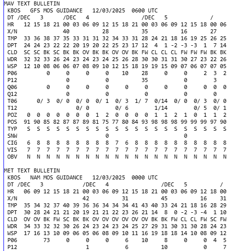
-
December 2025 regional war/obs/disco thread
weatherwiz replied to Torch Tiger's topic in New England
Might be a bit stronger WINDEX signal back across north-central New York towards Albany. A quick look doesn't seem to be the case around here but could certainly see some heavier snow showers whiten things up quickly. Would be like mid-to-late afternoon too so definitely localized travel impacts possible


