

weatherwiz
-
Posts
81,103 -
Joined
-
Last visited
Content Type
Profiles
Blogs
Forums
American Weather
Media Demo
Store
Gallery
Everything posted by weatherwiz
-
IN A WARNING!!!!! Let’s go!!!!
-
Might have to watch that cell going into Litchfield county
-
Haven’t heard any thunder but it’s about to absolutely downpour here. Sky is super dark as this closes in
-
Not so sure that lead area was anything meteorological. Kind of wild looping that though
-
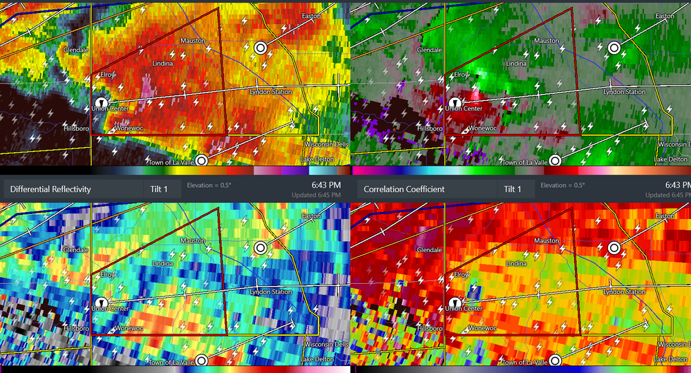
large tornado in wisconsin
-
beer?
-
This is more for Wednesday but wild differences between guidance at BOS for tomorrow 6z MAV: 65 0z MET: 57 9z high then dropping 7z NBM: 69 I was actually expecting the 13z NBM to tame down at BOS but nope...came in at 71 . Been that seems wayyyy too high. Highest 3hr value anyways is 64 which still might be a bit high...though BOS might have a chance to climb before the E winds kick in
-
Absolutely wild the differences in guidance in how convection develops/evolves tomorrow. the 3km NAM highlights exactly what I was thinking yesterday in terms of potential/evolution but it doesn't have much support. But then again, not one model has support from another. Ahh the fun of convective forecasting
-
lol
-
40's are normal for April?
-
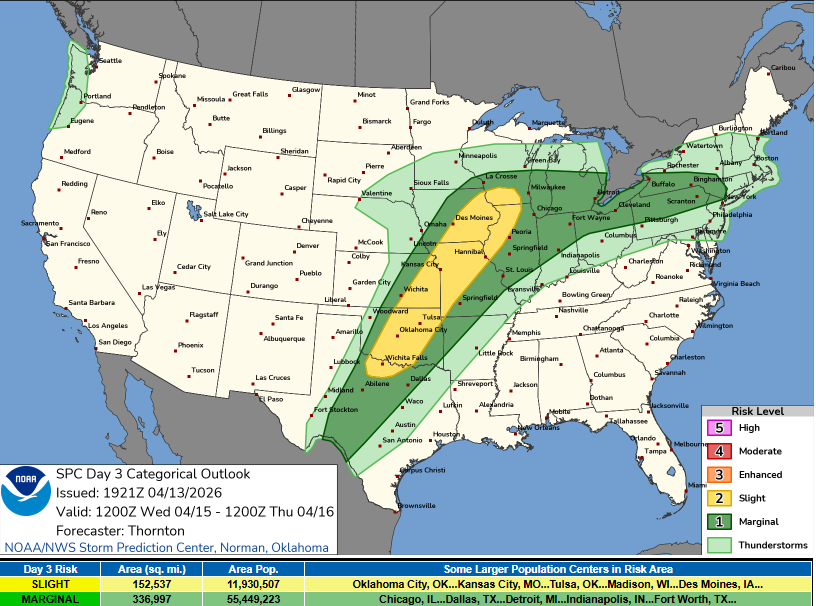
oh come on are you kidding me? Got the marginal risk but got cutoff right at the border
-
The 18z HRRR does have a line moving through late PM. Might be dependent on exactly how much heating there is. The overall forcing looks pretty weak but it does look like a weak boundary will be sliding through...could be enough to get things going. Looks better north though
-
I would not be shocked to see a large marginal introduced for D3 when the new outlook comes out within the next 45 minutes
-
better chance late Wednesday PM
-
Potential for some strong storms Wednesday evening for southern CT. Unusual timing for this time of year for strong storms but steep lapse rates along the coast with good shear/CAPE and some approaching s/w energy
-
sun out now. see lots of blue
-
This sucks @40/70 Benchmark With the NWS discontinuing NCEP/NCAR R1 and the switch to CORe, if I'm understanding what I'm reading correctly, PSL is not going to offer plotting of CORe, although it is listed under the list of datasets. NCEP.NCAR R1 will still be available for reanalysis purposes but may have to switch over to ERA5
-
Models have been hinting at this potential for the past 7-8 days with very little wavering...pretty impressive to see. I wouldn't be surprised if that got extended a bit east as well. One downside though is the overall forcing doesn't appear particularly strong. What this is going to do is likely negate this from producing scattered thunderstorm activity within the region as a whole. The best likelihood is probably going to be across like VT/NH/northern MA where there may be some better forcing and also on the edge of the stronger llvl airmass/theta-e gradient. Probably see at least one cluster roll through here. Maybe differential heating can pop some stuff elsewhere
-
Big difference in lapse rates on NAM versus GFS tomorrow. NAM keeps feeding in steeper lapse rates throughout the day while the GFS weakens them a bit before another surge of steeper lapse rates build in.
-
yup definitely going to need sun for sure, probably especially to our southwest because there doesn't seem to be much in the way of momentum to really blow this warm front through. Haven't looked at any guidance since Friday but I do recall on Friday thinking there was a chance we could be mucked in a bit longer on Monday. Could be a day where like Danbury, CT is able to just get into sun/warmer airmass and pull out a 73 while most everyone else is barely into the lower 60's. But idk...there might be an opportunity to start ridding of this lower cloud deck late morning
-
was just thinking the same thing In fact, the heat just kicked on But watch in about 3 hours or so we'll see rapid breaks and temperatures will soar.
-
20 days to go!!!
-
Also, there is much more to it than what the charts show. Structure/placement of the anomalies are more important than the raw value itself. A -NAO/-AO doesn't always equate to blocking. In that graphic, the NAO is largely forecast to be more of a weak signal with larger spread towards the end of guidance (typical), albeit the AO is forecast to be a bit more in the way of negative. Based on an evolution of the 500 pattern (at least on 12z GFS) one could argue the greatest potential for cooler temperatures associated with any negative AO would be northern Plains.
-
The one thing to keep in mind with using ocean temps (especially present or very recently) are the changes ongoing within the PDO domain, AMO, and of course ENSO region. But alot of studies and data have shown SSTs have increased over the years (hence the development of the RONI to incorporate this signal). It is also very likely that we are now headed towards the negative phase of the AMO so naturally we *should* begin seeing the Atlantic cool.
-
I don't think there is anything wrong with using a shorter period or using a longer period, but like I stated the user and readers just need to be aware and any conclusions being drawn need to factor this in. Quite a bit of information can be gained using both. Comparing to a shorter period and a longer period, you are more likely to see areas of higher anomalous values and when compared to the longer mean, you can get a sense of where "change" may be occurring more rapidly.


