

weatherwiz
-
Posts
81,103 -
Joined
-
Last visited
Content Type
Profiles
Blogs
Forums
American Weather
Media Demo
Store
Gallery
Everything posted by weatherwiz
-
30 days to go That is not an April Fools joke, we're into the final month before May.
-
And that they did!
-
Hopefully they bring the energy they had in the first
-
Thank God Bruins have been winning because everyone else has too. It’s amazing how so many teams are alive but they all win lol. Bruins still have a legit shot to get 2nd in the division. 1st isn’t impossible but slim
-
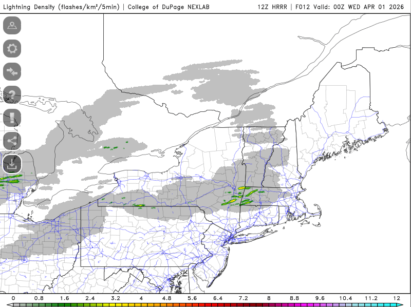
Looks like a TDS over Bainbridge, NY
-
Looking good for western MA and far NW CT AWT
-
That sucks man, sorry to hear
-
Early evening will be interesting across western Mass and far northwest CT.
-
Anyone have any stats on how well those extended range snowfall maps verified from like 10+ days ago?
-
because March has 31 days
-
Time to charge up the camcorder
-
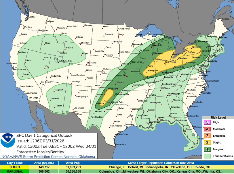
yup...had that look yesterday on guidance. Was waiting to see if SPC would expand the marginal and they just did
-
plenty of Strawberry Mojitos over the weekend in Miami
-
Very possible and in fact, most likely given what has been said. The Bruins are huge in having their forwards being able to play both sides of the puck well and having a strong game off the puck. This is the sole reason why Lysell has not been given much of an opportunity. I think this is a great philosophy to have, however, I think sometimes in hurts the Bruins too.
-
Some striking differences though on the mesos with the HRRR and (to some degree) RRFS the more aggressive of the guidance.
-
Could be some interesting storms late tomorrow afternoon and early evening right along the boundary. Might even see a decent line make its way into western Mass/CT during the evening. Its pretty unstable with steep lapse rates south of the boundary with strong shear
-
I would not be shocked to see Hagens before the season ends but the team may prefer him get playoff experience with Providence and may not want to burn his first year of an ELC for what only may amount to a handful of games. I was 100% confident they would have signed Hagens to his ELC once BC season ended but given they didn’t, not sure they will now.
-
I did not, I had something to do after work and Bruins are playing. If bruins were off tonight I probably would have. With going to Miami this weekend I won’t be able to watch Saturday night and I can’t even get updates for Sunday’s game. Flight back is 6:30 and game is 6:30 and I’m flying Avello which has no WiFi
-
I wouldn't be surprised if we don't make it until the end of summer lol. The plan is my girlfriend is going to go to the shelter and pick out a dog. I can't go and do it because I told her if we encountered pups that were a part of a family there is absolutely zero way I could just take the one, I would have to take the whole family. What I should say though is, the dog will pick her. That is how she ended up with the dog. She went to the animal shelter when she was living in Florida and went into a cage...all of the dogs ran and hid into the corner and only one went up to her and she figured that was the one. The dog had just been dropped off at the shelter a day or two before. Talk about fait.
-
Yes we 1000% will be, but probably not until later in the summer. My girlfriend will begin bar prep in about a month and is taking the exam the end of July and I will be doing two classes over the summer ( I debated taking the summer off but if I do two classes fall/spring/summer I will have my masters end of summer 2027) and they are only 10 week courses so we both are going to be super swamped. We both absolutely want to though. She adopted the dog when she lived in Florida, found him at the shelter when he was only 6 months old and she said he was badly abused. The first time I met my girlfriend and came to her house the dog and I got along right away. This dog was absolutely the most best, loving, sweet, and caring dog ever and he had such an amazing life and we want to provide that option to another dog too. We still have a cat so we're not totally pet-less.
-
That's terrible
-
We had to put our dog down on Monday and scheduled it to happen like 2.5 weeks ago. It was an absolutely emotionally grinding few weeks and really hard processing. I know things will get better over time but the process getting to that point absolutely sucks.
-
Flying to PBI from HVN 6:30 Friday morning. Headed to Miami for a few days for a bachelor party. Hoping that will at least take my mind off things after this week but much, much looking forward to a few days of temperatures around 80 with a touch of humidity.
-
We said goodbye to our dog today. Gentleman came at 3:00 as we chose an in-home option. We got to feed him everything he wanted and he was so happy. Hopefully he’s back to being able to walk and run on the other side again. This sucks though…absolutely sucks. Going to miss him so much.
- 314 replies
-
- 13
-

-
40 days!!


