

weatherwiz
-
Posts
81,106 -
Joined
-
Last visited
Content Type
Profiles
Blogs
Forums
American Weather
Media Demo
Store
Gallery
Everything posted by weatherwiz
-
Easier said then done
-
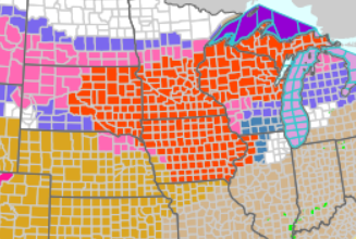
Reading the blizzard warnings in these. would be epic to experience one of these midwestern blizzards one day. True blizzard stuff
-
yup...not sure what vendors use as an algorithm for those wind gust products but there are as bad as the snow maps
-
Monday doesn't seem overly impressive for winds...nothing out of the ordinary for these setups. Best bet would be getting a solid convective line to hold but looks like it falls apart quickly. 3km though does suggest there could be some embedded strong convection though.
-
Can’t wait to bake in June/July with some Sonoran heat releases
-
Maybe we can use uber helicopter and take measurements at H85
-
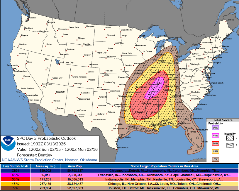
D3 45% area LFG
-
The upcoming stretch looks like spring in New England. Some mild days, some really mild days, then unsettled weather with FROPAS followed by some chilly days
-
Yeah I wasn't taking your post at 100% face value...figured there was some humor in there. I do agree though that the climate classification system could use some tweaking and maybe even introduce some micro-climate classifications (though I am positive there are...but they could probably use some tweaking too).
-
That is some serious early season heat building into the West. Bet we see some big wildfires get going
-
hey the classification system isn't perfect but aren't there like micro-designations anyways?
-
Actually its not really the timing that screws us, the trough sort of de-amplifies a bit and all the dynamics lift to our northwest
-
We'd probably see a marginal risk if not for the crappy timing
-
Technically as we are a continental climate type, our summers are defined as being warm and humid, so yes it will be a warm and humid summer
-
In about 15 or 16 days the CMC will get into May
-
Tuesday will be a day where mountains in VT/NH somehow pull off 5-8" with upslope
-
Highs well into the 90's to lower 100's within southern California Monday with teens in the upper-Midwest
-
yup doesn't seem to be any stations around POU reporting precip
-
just started sleeting here
-
It's not about what happens on May 1, it's about what it means. It's akin to like June 1 being the start of hurricane season...what happens on June 1 in terms of tropics? Nothing necessarily but it designates the start of the month where activity can start increasing. Outside of the Earth's tilt of the axis, what exactly happens on the first day of spring, summer, fall, winter...nothing really. It just marks a period in the transition.
-
Interesting note on the SSW (well lackof). One thing I find interesting this winter (based on the pattern) was the lack of a more active STJ (maybe that was a product of ENSO state?). Of course, when we did have the active STJ with the blocking in January, we saw what happens when those to coincide. I'll say this and this is going to yield alot of agree-to-disagree, but after the last few years or several years...give me an active southern stream versus an active northern stream any day of the week. Sure active northern stream comes with plenty of opportunities but we just try to will them a chance because of the probability (or potential game) with the mindset of, "well one of these have to work out". what does work out and I bet with high probabilities (or "higher") is throwing an active southern stream into the mix when you have blocking and the polar jet throwing PV lobes into our side of the hemisphere.
-
We really did get lucky here this winter and fortunately we were able to cash in. While I didn't write up an official outlook, I did make several posts that I was fearful of anomalous above average temps across the U.S. based on how the state of the PAC was right through fall and into early winter. But I think you could argue too (and I'm sure Ray will address this in his post analysis) that the state, obviously combined with the early on SSW really helped to save us from those anomalies stretching east.
-
I am curious to see if we will see wind advisories expand to cover all of SNE. The overnight timing of the LLJ though complicates things but we do have strong CAA so that may help realize wind advisory thresholds.
-
Actually region as a whole tomorrow has a good chance for some squalls or at least probably a mixture of rain/snow showers (or predominately snow).
-
May see multiple rounds of squalls NOP tomorrow evening into the early overnight. Even a bit unstable too so can't rule out some thunder/lightning


