weatherwiz
-
Posts
81,103 -
Joined
-
Last visited
Content Type
Profiles
Blogs
Forums
American Weather
Media Demo
Store
Gallery
Everything posted by weatherwiz
-
Going to be great to get some boomers tonight
-
I wonder if that line can maintain enough later this evening to get a storm storm into the Berks
-
Going to suck when May comes and these have no problem yielding widespread stratus with drizzle and temps in the 40's
-
I wonder if the extreme shallowness of this airmass back door) should have been a flag that the NAM was overstating the impact too much. The airmasses with backdoors are generally shallow but this one seems even more so than your usual. There is no secret that this time of year (and 99% of the time) you toss the NAM temperatures. But when you have situations like CAD or BDCF potential...well the NAM deserves alot of weight. But the low-level airmass in place is quite unseasonably warm and I guess even for early March, we have enough solar heating and mixing to either halt the BDCF or weaken it. If you follow MSLP evolution on SPC mesoanalysis you can clearly see either the boundary weakening or even kind of retreating. Despite the stronger heating though, we're clearly having trouble mixing so there is definitely something going on within the BL.
-
Interesting how the parent NAM has hardly any QPF tomorrow while essentially every other model does
-
If anyone wants or is looking for winter storms, the northern Rockies, northern Plains, and upper-Midwest is where you'll want to be
-
Meanwhile down in Hawaii animated.mov
-
This is nuts
-
Amazing what strong mixing with a warm low-level airmass can do coupled with WAA ongoing in the low levels as well.
-
Really no complaints. Locally the blizzard was disappointing but I was expecting that here given location (though the screw job was a bit worse than I was expecting). But it was a solid winter. The only thing I will hate about the winter is our dog's condition and mental health plummeted. Around January he refused to go outside anymore and really became more depressed. We really wish we had done the wheel chair early last summer instead of late in the fall because he was so excited using it. But then the cold/snow/ice came and that was it. Unfortunately to the point (plus with kidney failure which came out of nowhere) we have to put him down in 3 weeks. I'll always wonder if the cold/ice/snow played a big roll in this or if just an unfortunate coincidence. But several snow events here, most small, one big one in January then a few moderate events. The scenes outside after the snows...beautiful. So no complaints here
-
Tomorrow is going to be a slap in the face. Temps will finally warm up...during the evening and overnight but then drop off Thursday AM with the fropa lol. Maybe we can get an early season Sonoran heat release with EML to end March or begin April
-
Once you start getting days like this in March it's kind of hard to want to go back in the direction for more snow lol. I mean if we're talking about something like 12-18", hell yeah bring it...but a few days of this and you just want it to stay. Its almost like a tease because you know we've got our share of 30's and 40's with clouds and drizzle coming but on the other hand, this is a taste for whats's to come in another few months
-
I'm not really seeing a whole lot to be excited about in terms of winter storm threats or potential for the second half of the month. This doesn't apply to northern New England or elevations though...they will always find a way to sneak in some accumulating snow well into April. But when it comes to the GFS at least, I'd be very skeptical about it being way too aggressive with the EC troughing and colder look. Yes, that look or "tenor" has been a theme during the winter but we're moving into a new regime now with the hemisphere and wavelengths transitioning to the warmer season and this is when the GFS bias for extended range trough/cold may be overestimated. Yes other guidance hints at this but not to the degree of the GFS and something more along the lines of transient. Still plenty of cold to our north which keeps us in the game but nothing to me looks overly excited...especially since antecedent airmasses are going to suck.
-
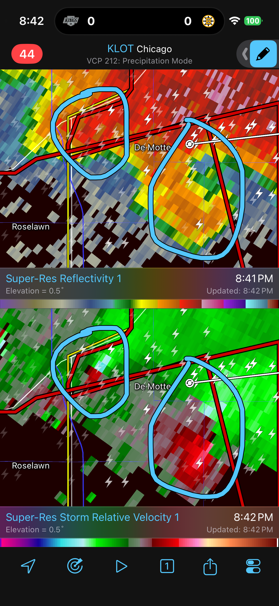
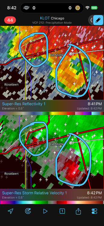
3km with some violence ripping across PA tomorrow. May even see some elevated thunderstorms move across SNE tomorrow night...pretty decent MUCAPE on the 3km
-
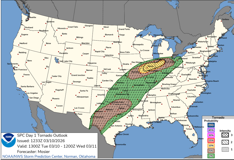
I believe this does change the probabilities which designates the categories. For example, it looks like it will be more difficult now to get a high risk day which I think is a great idea because really if a high risk is issued...you want that to be held for days where widespread significant severe is going to happen. This may hopefully reduce more of the high risk "busts" we have seen. I am with you...I am definitely not bashing this either, just trying to understand it more. But with what you said I think makes sense and if that is the case and purpose I can understand it a bit better. I'm sure there is some literature on this, I've only read the little bit on the SPC site.
-
That's how I kind of see it. So in that tornado probability that intensity 2 area is supposed to indicate if a tornado occurs, the reasonable max intensity is EF3 and the intensity 1 area is max intensity EF2. I think though this is supposed to help local forecasters and emergency management to better communication to the public but I don't see how this helps.
-
I am still trying to gauge this new conditional intensity thing. But I am with you...seems odd the entire thing isn't filled in and what additional value does this have over the regular hatching? But I guess its to highlight what the "max intensity" may be. IDK...I feel like this is going to cause more uncertainty or even hype that isn't needed
-
First go around with an intensity 2 for tornadoes (also have it for hail in Texas). Very curious to see how this changes or enhances public communication or if it just adds confusion. I wonder what @OceanStWx thoughts on this conditional intensity addition is.
-
It's going to be super close WOR. Looking at some soundings from the NAM WOR you can see a more SE component to the wind but (Even though its March) if the NAM is overdoing the clouds/AM precip, it would not take much to mix out that shallow and subtle layer. Could be a day where DXR gets to like 66 and BOS 41
-
The NAM is also a bit more robust with clouds/precip Wednesday too
-
Gotta love this time of year BOS for tomorrow 6z MAV: 66 0z MET: 52 7z NBM: 62 We've reached the time of year where the NAM is as useless as ever with temperatures (unless there is a front overhead/nearby) or we have CAD.
-
Could see some showers with thunder develop around/after daybreak Wednesday morning on the nose of the advecting MUCAPE
-
Pretty crazy seeing a long-tracked tornado on the ground in Michigan with temperatures/dewpoints only into the 50's. That cell is a beast
-
Can't disagree with this
-
It's such a tease looking at that. We're so close to the warmth but the heights are totally compressed up here. This isn't a good look either in the Southeast, especially Florida where I think they are in a pretty bad drought and there are major fire concerns. But that is also setting up to what could be an extremely active March in the Great Plains there. But for here...certainly going to be several wintry mix threats.