

weatherwiz
-
Posts
79,906 -
Joined
-
Last visited
Content Type
Profiles
Blogs
Forums
American Weather
Media Demo
Store
Gallery
Everything posted by weatherwiz
-

“Cory’s in LA! Let’s MECS!” Jan. 24-26 Disco
weatherwiz replied to TheSnowman's topic in New England
I’m really hoping this pans out and I can get a foot. My girlfriend (who I met in 2021) moved up from Florida late 2018 or so and this would be the biggest storm she’s seen. Thought it would happen last year but Connecticut got crushed. I’m also hoping to see what the dogs reaction would be (if he cares). He’s coming the end and it would be cool to see if he would like it and go around in it with his doggy wheel chair -
“Cory’s in LA! Let’s MECS!” Jan. 24-26 Disco
weatherwiz replied to TheSnowman's topic in New England
We can’t get greedy! -
“Cory’s in LA! Let’s MECS!” Jan. 24-26 Disco
weatherwiz replied to TheSnowman's topic in New England
SWFE, NWFE, Miller A, Miller B, clipper, redeveloper…who cares. It’s going to snow and it’s going to snow a lot -
“Cory’s in LA! Let’s MECS!” Jan. 24-26 Disco
weatherwiz replied to TheSnowman's topic in New England
You couldn’t ask for a better setup for the region given the last several years. Everyone wins in this setup. There really isn’t a screw zone. It’s a region wide dumping -
“Cory’s in LA! Let’s MECS!” Jan. 24-26 Disco
weatherwiz replied to TheSnowman's topic in New England
meh we'll see how these cloud physics work out for me -
“Cory’s in LA! Let’s MECS!” Jan. 24-26 Disco
weatherwiz replied to TheSnowman's topic in New England
With the way they plow here I wouldn't be shocked if they end up closed through Thursday. Probably won't see a plow on my street until Tuesday. -
“Cory’s in LA! Let’s MECS!” Jan. 24-26 Disco
weatherwiz replied to TheSnowman's topic in New England
Yeah I don't see sleet reducing totals anywhere. The bulk of everything already occurs. Its not a big deal -
“Cory’s in LA! Let’s MECS!” Jan. 24-26 Disco
weatherwiz replied to TheSnowman's topic in New England
Wasn't entirely sure I'd get to do into enough detail to make a forecast but alas I did. I originally had the whole area of 12-18" but wanted to highlight that potential for some higher amounts in northeast Mass...I think that signal could be very real. Didn't want to go crazy and throw out 18-24" contour so just bumped 12-18 to 10-15 to add a 15-20 area. This is what winter is all about!!!!!! LFG!!!!!!! Massive snowstorm and a Pats trip to the super bowl incoming. Someone pinch me I'm dreaming https://weatherwiz.blogspot.com/2026/01/significant-snowstorm-to-impact.html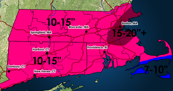
-
“Cory’s in LA! Let’s MECS!” Jan. 24-26 Disco
weatherwiz replied to TheSnowman's topic in New England
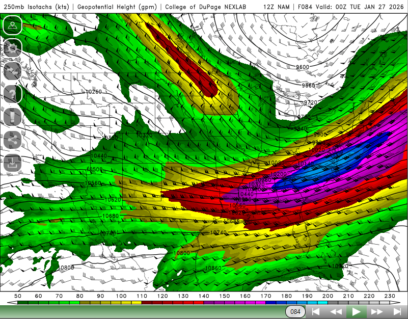
Its the 84 hr NAM gut that is a lot of DPVA throughout the day Monday (seem better animated of course) And we're in the left exit region of this monster jet streak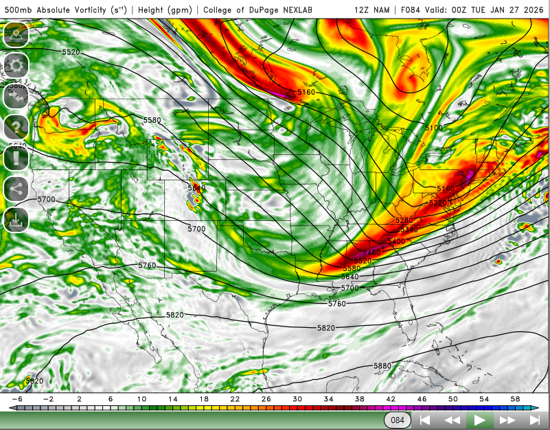
-
“Cory’s in LA! Let’s MECS!” Jan. 24-26 Disco
weatherwiz replied to TheSnowman's topic in New England
The coastal front is going to be insane. I think we know where the jackpot zone is going to be -
“Cory’s in LA! Let’s MECS!” Jan. 24-26 Disco
weatherwiz replied to TheSnowman's topic in New England
yeah not sure if its a cod thing but its a little funky in that regard. but thats the type of lift we want to see! -
“Cory’s in LA! Let’s MECS!” Jan. 24-26 Disco
weatherwiz replied to TheSnowman's topic in New England
Oh here we go...northeast CT right along the RI border. This is it -
“Cory’s in LA! Let’s MECS!” Jan. 24-26 Disco
weatherwiz replied to TheSnowman's topic in New England
Going to be a hellacious fronto band moving through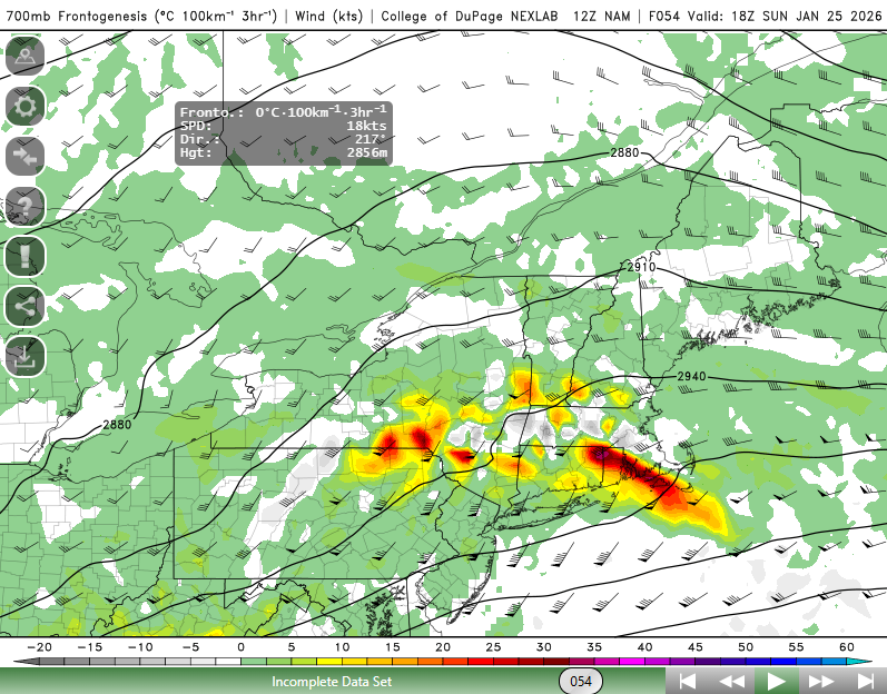
-
“Cory’s in LA! Let’s MECS!” Jan. 24-26 Disco
weatherwiz replied to TheSnowman's topic in New England
Nothing loads for me either I forgot all about his page...his site used to be my go to for soundings back in the day. -
“Cory’s in LA! Let’s MECS!” Jan. 24-26 Disco
weatherwiz replied to TheSnowman's topic in New England
Yup...great point. I'll say too...looking around at various locations, I would like to start seeing some stronger omega values popping up on some of these soundings. It's easy to get carried away with ratios given everything but we aren't going to automatically snag very high ratios because the DGZ is deep and its cold. There are really a ton of details to go over and analyze on this -
“Cory’s in LA! Let’s MECS!” Jan. 24-26 Disco
weatherwiz replied to TheSnowman's topic in New England
Ratios will def be great up that way...the average should easily be in the 15:1 to 20:1 range up there and probably upwards of 22:1 to 23:1 during peak intensity. -
“Cory’s in LA! Let’s MECS!” Jan. 24-26 Disco
weatherwiz replied to TheSnowman's topic in New England
If that Monday snow verifies I think someone in northeast MA may pull >24" I would not forecast that now but I think there could certainly be some reports. This storm is going to be full of surprises...I can't get over the whole DGZ thing looking around on bufkit lol. I think dendrite mentioned this about the snow ratios and how its difficult to maintain upward of 20:1 - 25:1 but where and when the best lift is occurring...there is going to be a swath verifying those ratios at least for a brief period of time -
“Cory’s in LA! Let’s MECS!” Jan. 24-26 Disco
weatherwiz replied to TheSnowman's topic in New England
I like the good ole fashion wood -
“Cory’s in LA! Let’s MECS!” Jan. 24-26 Disco
weatherwiz replied to TheSnowman's topic in New England
I could picture the NAM ending up with one of those runs that produces 1.50-1.75"+ of QPF. I really need to get to Lowes and get those yard sticks. Might have time to go Saturday, hopefully they'll have some in stock -
“Cory’s in LA! Let’s MECS!” Jan. 24-26 Disco
weatherwiz replied to TheSnowman's topic in New England
Nothing to whine about so people unsure of what to do -
“Cory’s in LA! Let’s MECS!” Jan. 24-26 Disco
weatherwiz replied to TheSnowman's topic in New England
This is why I can't wait until we get into meso model range. The mesos I think should handle this very well and this is when we can really talk about the potential for >15" totals and where those would be most likely to occur. -
“Cory’s in LA! Let’s MECS!” Jan. 24-26 Disco
weatherwiz replied to TheSnowman's topic in New England
Nothing good comes out of doing that. You can raise awareness and prepare the public without having to go off the walls -
“Cory’s in LA! Let’s MECS!” Jan. 24-26 Disco
weatherwiz replied to TheSnowman's topic in New England
If we're going to be looking at something along the line of 15-20-24" somewhere that idea won't become more serious until we're inside of 24-36 hours and can start diagnosing banding more accurately and getting a solidified feel on snowfall ratios, lift, etc. This is why that map of 1-2' was absolutely stupid this far out. -
“Cory’s in LA! Let’s MECS!” Jan. 24-26 Disco
weatherwiz replied to TheSnowman's topic in New England
That would be a huge hit on the GFS, especially with the 850 low developing just south of the region. I like how the sfc low and 850 low go virtually west-to-east to our south with a bit of elongation to the low...that should help (I would think) result in a much wider than usual fronto band (combined with other factors of course) than usual. This inflow oof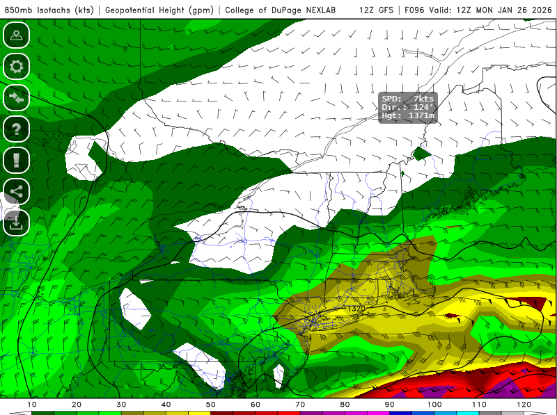
-
“Cory’s in LA! Let’s MECS!” Jan. 24-26 Disco
weatherwiz replied to TheSnowman's topic in New England
For old times sake can we have the storm mode in bright red at the top of the page? maybe a radio show too


