weatherwiz
-
Posts
79,820 -
Joined
-
Last visited
Content Type
Profiles
Blogs
Forums
American Weather
Media Demo
Store
Gallery
Everything posted by weatherwiz
-
Whatever happens with the eventual track, conditions look ripe for this one to get pretty strong.
-
ughh that's sad
-
ehhh even with the farther west track it probably wasn't a bad idea to cancel. The weather still won't be great. It will be pretty breezy out and with the wet ground there will be the risk for some downed trees.
-
Actually NAM may hang the front up a bit east of the CTRV
-
Yeah overall the rain doesn't seem to be a big story here. We'll see some typical poor drainage flooding as the axis of heavier rain moves through but there is even a possibility that starts to falter. Almost looks like the cold front starts racing eastwards and becomes a bit removed from the better ulvl dynamics. Have to see how many breaks of sun we can muster in the morning but I suspect we are going to see lots of showers popping up but it won't take much for them to do much if they can get semi-decent cores.
-
We should see a slight for 5% TOR I would think (maybe with 1730 update). If CAMS start spitting out some more aggressive convection ahead of the main line we may see enhanced risk for 10%. Dews 75+ with this shear is eye opening.
-
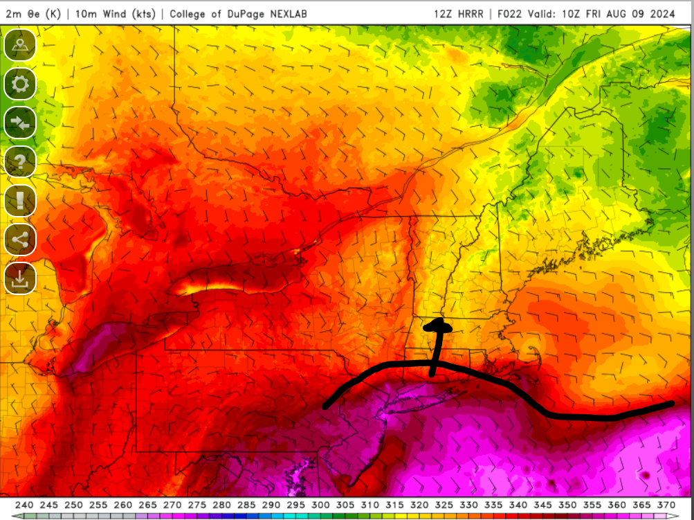
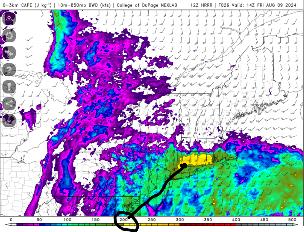
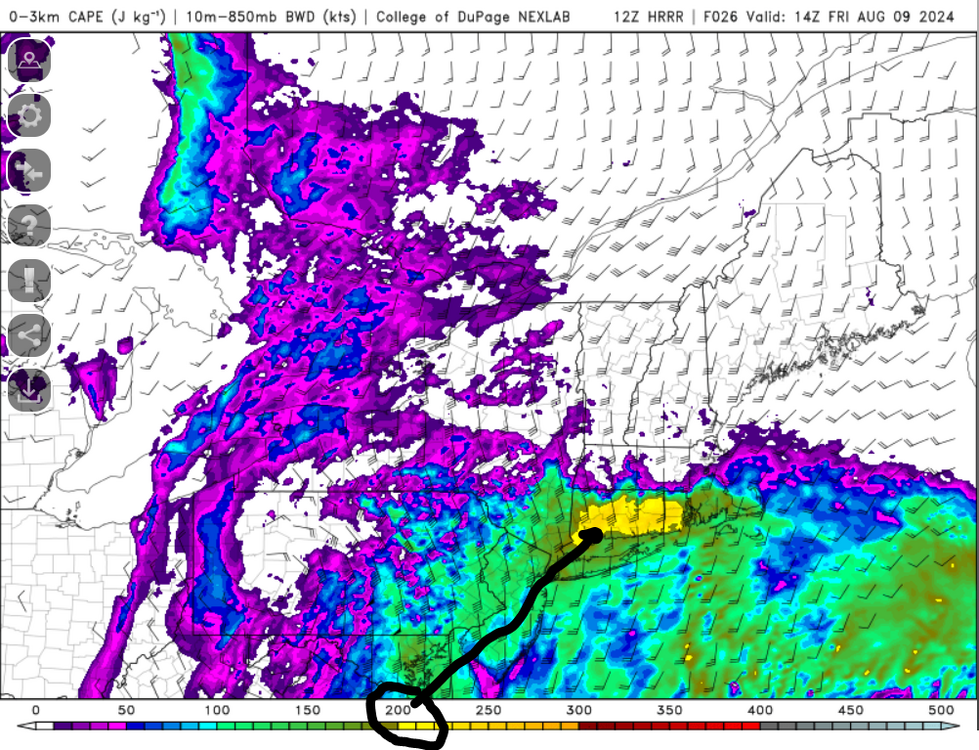
If the HRRR is correct, there may be some enhanced tornado potential between 5 AM - Noon (from south to north across the region). Warm front lifting northwards during this period and is characterized by a very rich llvl theta-e airmass As the rich llvl theta-e air transports northwards, the HRRR has a pocket of 3km CAPE > 200 J/KG surging northwards. This is some significant llvl CAPE. The greatest overall shear is a bit later in the day, however, the HRRR keeps 150+ 3km CAPE in place through the day. All in all have to watch for anything along that warm front early on.

-
Wow that's pretty wild. Sounds like something you would see over the ocean. Also looks like tomorrow is evolving to be much more progressive, this may limit some of the flooding potential a bit. If we are able to break any peaks of sun tomorrow there could be some nasty cells.
-
Even showers tomorrow are going to rotate
-
Interesting indeed, wasn't even thinking about that's a great observation.
-
Very impressive llvl jet and with dewpoints probably 74-77 there will be more than sufficient llvl instability. What can be a killer on these setups is the atmosphere is just so moist and with no capping things just pop off and can struggle to mature. With the greatest forcing so far west, however, we may have room for increased tornado potential here during the day.
-
that's alarming for D3 but I take these machine learning with a grain of salt
-
I don't think that was the case. 1) When Debbie was a swirl of clouds, forecast models struggled since there was no defined center yet, that's why there was a large disparity in initial track, anywhere from eastern Gulf to the southwest Atlantic. Models would just pick up on random bursts of convection as a "Center". However, once the swirl organized into a tropical wave and eventually developed a more defined center, it was much easier for models to get a handle on the track. 2) With no steering flow, Debbie just sat and spun across the Southeast and meandered into the Atlantic, off the coast. Now that we have somewhat of a trough digging up north, combined with an approaching front, the remnants of Debbie are being driven northwards. I don't think strength of ATL ridge played much of a factor here.
-
Friday and Friday night are going to be intriguing for some tornado potential. With the axis of heaviest rain west, if we can keep the dirty warm sector free of widespread precipitation, that will give any cells a chance to develop mature enough updrafts to warrant the risk for a few brief tornadoes. Could even be some potential overnight as activity pushes east with the cold front. Greatest flood potential going to be PA into New York and then across the favored upslope regions in VT/NH but oof...with that llvl flow and moisture, it could be very ugly there. Guess one saving grace is hopefully the eastward progression is progressive. But I do fear that models are underestimating rainfall totals which will occur with the popup downpours and showers.
-
Going to see a nasty bow rip across PA later.
-
Actually, with some of your luck these past few years with rain you may end up floating away
-
agreed, something like that seems more reasonable to me. With the focus well off to the south and then north right along the llvl warm front but those totals (on a widespread scale) may be overdone.
-
Part of me wonders if this is a bit overdone on the northern extent. Have to watch the area outlined in the Slight Risk by the SPC. How much convection and how organized the convection becomes will be critical. This could rob much of the moisture. The sfc boundary is also pretty far south, however, it does appear there is a warm front aloft displaced much farther north (through central New England) so this could certainly be a focus for heavy precip north, but I think the convection would end up robbing alot of that moisture. There is some decent vort moving through though.
-
Could see a decent looking bow echo become established across PA later on. Should that materialize that could have a big influence on northern edge of precip shield.
-
Could see some pretty bad flooding along the south coast tonight. Have to see if there is any room for some strong-to-severe thunderstorms/tornado risk, however, that might be more for Long Island. End of the week/weekend is extremely concerning for VT with upslope aided flow. Tonight though is an ugly look for like NYC area.
-
I used to like collecting acorns as a kid but one time at recess in elementary school I picked up an acorn and turned it over and there was a green spider inside it. I screamed, threw it, and never picked one up again.
-
I'm just kind of bustin too with this I have been watching closely though each day, one worry I have is something gets going very quickly and threatens anywhere along the Southeast Coast. Until we either start to see better organization the models will almost be kind of useless. But if we go into Friday or Saturday and this isn't looking better it's probably toast.
-
I am interested with this due to potential impacts along the Southeast coast but overall not too excited on this yet. The Euro has certainly been one of the more consistent and impressive with potential development. I would expect models though to continue struggling just because we don't have much to work with yet, so essentially it's just watching how this evolves on satellite throughout the day.
-
The GFS was certainly something We'll see how quickly any organization can occur once into a more favorable environment although dry air may still continue to be somewhat of an issue.
-
Can we even say winter is over anymore when it never even begins?