weatherwiz
-
Posts
81,152 -
Joined
-
Last visited
Content Type
Profiles
Blogs
Forums
American Weather
Media Demo
Store
Gallery
Everything posted by weatherwiz
-
I think everyone needs to go to the local package store and grab a 40 of Steel Reserve. I may do that soon. I’ve only had two Steel Reserves since December 2018…might need to re-introduce them back.
-
I’ve driven myself so nuts these last 3-4-5 winters that I think I just look for the bad as a coping mechanism but in all seriousness…these last several winters have pissed me off. I am so sick of looking in the extended and seeing patterns which are “favorable”. I would have a friend who does landscaping text me once in a while (he follows a lot of different weather sources) and when he would catch wind of something he would text me, “what’s your thoughts?” And I would say, “yeah I’m super excited, this looks good and favorable for snow”…then nothing would happen. It just became embarrassing and quite frankly pissed me off. So this has driven me. maybe 20-30 years ago you would just look at the pattern in the extended and just derive some thoughts based off the pattern, but we’ve come along way in this field. Perhaps this is just wishful thinking by me, but I am a firm believer we’ve come far enough in this field to where we can go further with just pattern assessment and just quickly say the pattern looks good based off blue colors in the East. We’ve seen enough of these “good” pattern not to produce to the point that we can all sit back and be like, “alright what’s going on here?” Obviously a reason here is how the pieces evolve and interact within the pattern but I fully believe we can sniff that out well ahead of time in some cases.
-
Those heights get any lower and you can probably kiss the stratosphere at the base of Mount Washington.
-
Most of these weather Youtubers are awful, however, unfortunately they are mastering the game. They know exactly what gets clicks and subscriptions and unfortunately some of them are probably making some damn good money from this stuff.
-
I really hope it works. Even if it doesn't we still have the rest of the month and February (even March) which can always deliver but if this winter ends up another dud...then I really hope we can start stringing together some neutral ENSO years. The entire atmosphere just needs to be flushed. This back-and-forth of Nino/Nina sucks. I bet if we had the neutral ENSO background state and got the good PAC/Arctic looks we would be cashing in handsomely or at least having seasons closer to average.
-
This is going to feel like the longest two weeks ever. We still have like another 5-6 days before that period gets around D5
-
What's wild to think about is if we were to get a March '06 or '12 redux, we're only two months away from getting 70's and 80's
-
I hate these features because they can really muk things up and its very difficult to have an idea of its influence.
-
Probably an unpopular opinion but I want to go back to the days of injecting southern stream shortwave energy up the coast and more of a bonus with northern stream phasing. I know we don't need southern stream energy to get storms up here and even big storms but the northern stream alone isn't doing jack shit for us. I'm curious to see if that cut-off low southwest of California is either going to help us or royally screw us...or maybe best case not be much of a factor.
-
I think in addition to the block relaxing we would also want to see the pattern reload some. I think if its just the block relaxing on its own then we probably get screwed because of a stale, rotting airmass. Isn't this what happened in 2009? or maybe both 2009 and 2011.
-
Maybe some strong storms tomorrow evening into early overnight from New Jersey into Fairfield County Connecticut?
-
This is why I do like the 10th-12th period that several have mentioned, it seems to offer the best potential for good shortwave amplification and potential for deep trough amplification...of course this could also result in cutters but this is where we want some degree of blocking.
-
A few days ago though we were really only going out until around the 10th or 11th on the OP. It is becoming more active with shortwaves after that period but everything is a chaotic mess and yes...not uncommon given its way out there but outside of this Wednesday/Thursday (which isn't fun for anyone except the moose up north) we have to go well into the first week of January before there's even something remotely possible to track and even then could be playing with fire.
-
Agreed, without turning this into another Friday night posting disaster, I won't say much else but it will scare me if we're going into mid-January with one legit "threat". I just don't like how chaotic everything looks within the longwave pattern...it's not a smooth pattern (if that makes sense). I get the ensembles are the way to go in the medium-to-extend range but sometimes the smoothing done by the ensembles is not a good thing, especially when there is too much chaos on-hand. Think back to was it 2010 and then again in 2013 when we had those epic stretches...we had a beautiful longwave pattern but there wasn't a whole hell of a lot of chaos. I thought about it like a railroad track...you have the longwave pattern (train tracks) and then a steady supply of shortwaves (the train) with little destructive interference. This...just looks like a chaotic mess. When I see that it just leads me to believe that you really only have one legit shot at something. That's why I was saying cold/dry with the one potential in the 10th-12th when there looked to be the most favorable alignment of teleconnections.
-
I seriously hope the 10th-12th period works out. Not optimistic about the period several days prior but please let this period work out. Feels like that period will never get here and its even crazier thinking that will be closing in on mid-January
-
Somewhere in NNE is going to end up making out well Wednesday probably from northern New Hampshire through interior northern Maine.
-
Getting a little excited for some thunder later tonight
-
meh I don't think ENSO state is particularly dominant or a major driver right now. If anything, there may be quite the hangover from last years EL Nino. I was looking back and this December ended up playing out how I thought last December would
-
I can't remember which one it was...maybe it was 2013? But I remember getting royally screwed in West Hartford...I mean I think I still got around a foot or so but a far cry from the 18-24'' expected. I remember alot of pissed off people that night because the radar was just so bandy...it was like looking at a tropical system.
-
yes, thanks.
-
If precipitation becomes too banded then you're dealing with too many subsidence zones. There were a few big ones I think this happened with in the early 2010's. Areas that got into the subsidence zones got screwed mightily.
-
I’d prefer something in the 980’s. Any lower (hell even in the 980’s this could become a concern) you start to worry about precip shield becoming more banded…which has screwed us in the past. Really hoping this period around the 10th works. edit 70’s to 80’s
-
?
-
I would imagine it would be difficult to muster up warm anomalies to beat those, even with the climate regime we're in. Even in the warmest of patterns, we're likely to at least get at least a few strong(er) FROPAs to push through where, even if brief, it's enough of a cold shot to really damper the anomalies.
-
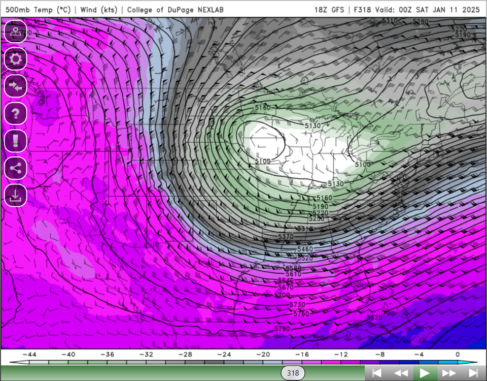
That's a massive area of -45C to -46C 500mb temps...can't recall too many times seeing that within the CONUS