

weatherwiz
-
Posts
81,152 -
Joined
-
Last visited
Content Type
Profiles
Blogs
Forums
American Weather
Media Demo
Store
Gallery
Everything posted by weatherwiz
-
MCI also closed
-
This is not even close to being done. Given the factors evolved, particularly with the idea of phasing northern/southern streams we aren't going to have a solid idea until probably Tuesday. My thinking is that beginning with Tuesday 12z run we are going to want to see continuity. At this point, we're going to continue seeing run-to-run differences with the handling of each stream and that is perfectly normal at this stage.
-
Going to be some serious thunder freezing rain and sleet tomorrow across southern Missouri through southern Illinois and Indiana. This sounding is nuts
-
I was a huge night owl as well. Used to stay up until all hours of the night and be out with friends until 1-2 AM. For some reason I always had more energy at night then during the day. But once I started working full time, I was working 6 AM - 3 PM and would have to wake up around 4:15-4:30 AM...that KILLED me. It was brutal, I had zero energy in the afternoon and weekends I was dead. I would try going to bed by 8 PM but I couldn't fall asleep until midnight. I ended up having to switch to do a typical 8-5. If I could though...I would love the earlier day, I wish I had the energy to wake up 5-6 AM. I actually grew to like some aspects of it but it was killing me. I don't know how people do it. I guess they must get like a solid 8 hours of sleep. My problem is I wake up every 2 hours or so.
-
Wouldn't like the 12z not be available until like 4-5-6 PM? and literally it was like one product freely available? I could be wrong but once I got introduced into forecast models I thought that's how it was.
-
100%. Swayman hold out for all this money to "set the goalie market" and all of a sudden forgets how to goaltend.
-
My favorite part of the day is going to bed. Even on weekends I usually go to bed like 9:30...sometimes a bit earlier if the Bruins aren't playing.
-
I remember staying up for 0z models and staying up until like 3-4 AM lol...kind of miss those days but can't do that anymore. I can barely stay awake by the time the 3rd period of Bruins games get going...makes it even worse they put me to sleep.
-
Our chances just went up!
-
I've been screaming for some more southern stream involvement to change up our luck so I hope this does it. Also, keep in mind we're likely to see some wavering between "storm" and "no storm" over the next 2-3 days because of how critical a phase is and we'll likely continue to see some inconsistency from model-to-model and run-to-run regarding this. But probably beginning 12z models Tuesday...we want to start seeing consistency with a great phase and track.
-
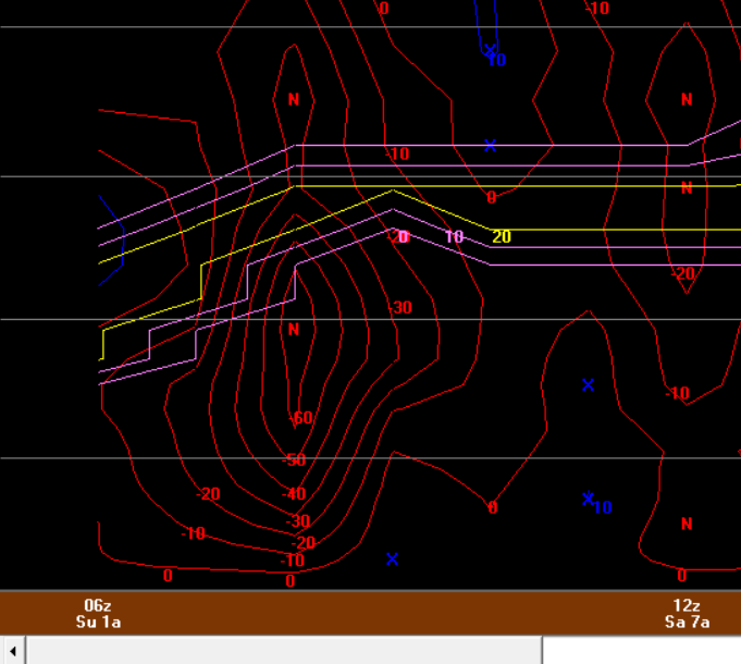
ahhhh yes stimulation. I hope as we get closer we're seeing a perfect crosshair signal with -50 to -60 ub/s.
-
I think its fun to look at those type of details even far out...if anything so you at least make sure you're covering all the bases as you get closer to forecast time. I'll be posting some bufkit profiles soon we all can geek over!!! 18z bufkit should be out in 5.5 minutes
-
I'm going to go buy a yard stick this week
-
I was getting nervous when I saw the tucked look but was pleasantly surprised when I saw the thermals...thank you block. I can't wait for the 18z GFS bufkit. Thankfully this is just inside the 180hr mark but I can't wait to geek out over omega overlaid onto the snowgrowth...I don't care that its way out there....I'm geeking out.
-
Despite being a week out and as intense of a solution as this is, the good news is this isn't farfetched at all...it has merit.
-
That would be something...widespread blizzard with major coastal flooding.
-
This is going to elicit one hell of a storm holy shit
-
You don’t post funny stuff much but this is gold
-
It would be amazing if we could start processing these complex equations even faster and start rolling out model data more quickly. It sucks having to wait 2.5-3.5 hours from initialization time .
-
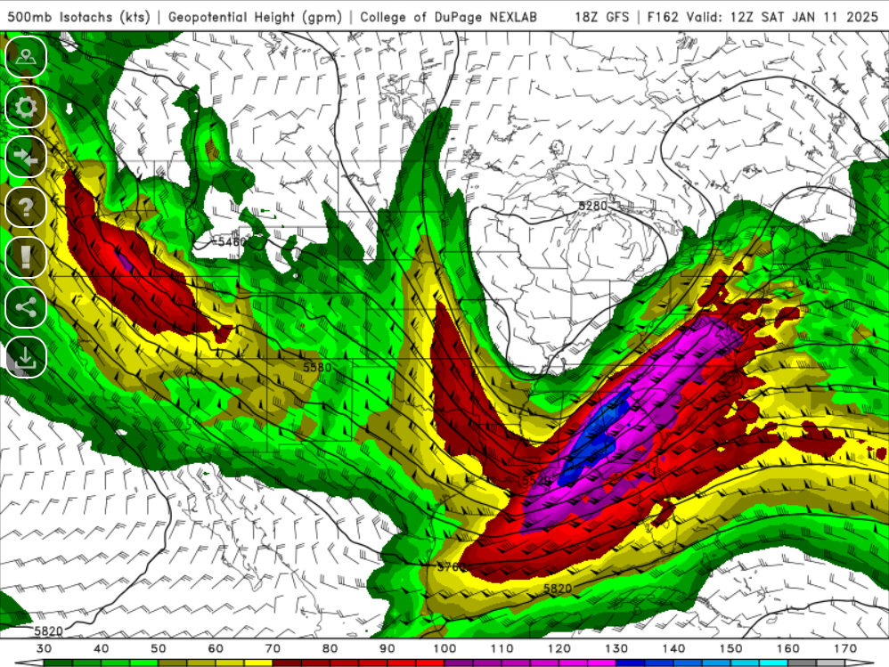
That is going to be some storm end of the week from northeast Texas through Arkansas, Tennessee, and the mid-Atlantic. Some areas going to get crushed...I bet the Smokey's pick up like 3 feet of snow.
-
That is a very low confidence period right now, largely due to the immense spread with how the SW energy is being handled. There is going to be lots of influences as to how any system within the deep southern Plains develops and evolves. We really may not have a clear idea on this until probably Tuesday.
-
That's it. It's one thing to see a good looking pattern in place, but it's a whole other ball game when it comes to how the pieces within the pattern are moving and quite frankly, it's not the pattern which produces weather, it's how the pieces are moving, evolving, and interacting which produce the weather.
-
I was mostly refereeing last week and the first week of January, which at that point, was really how far out the OP models were going. I know I'll always get chastised for saying this and I don't care but the charade of getting excited because of pretty blue colors in the East has faded with me. It's one thing to look at the pattern but you also have to see what is going on within that pattern and from what I was looking at - I was not excited. I'll keep saying this until the day I get banned or suspended or whatever, but if you keep saying things look good 1,000 times and nothing happens, at some point one needs to say to themselves, "maybe this isn't as good as originally thought". It seems like we're stuck on ideologies from 20-30 years ago. With each passing day and weather phenomena our dataset grows and continues to grow. There was a point in time where you could argue weak La Nina's (or even certain ENSO phase/strength) correlated well with good winters here...but as this dataset has continued to expand, correlations which were stronger 20 years ago aren't as strong now. We have enough of a database now to where we can probability better identify and differentiate these types of patterns and separate what is truly good versus what isn't good. I know for myself at least, I got tired of telling myself (and friends who asked) yeah this upcoming pattern looks good for snow and then nothing happens. Not sure how anyone else feels about that but you can only say something over and over without result before having to go back to the drawing board.
-
This is true
-
Only 3 more full months until May


