

weatherwiz
-
Posts
81,153 -
Joined
-
Last visited
Content Type
Profiles
Blogs
Forums
American Weather
Media Demo
Store
Gallery
Everything posted by weatherwiz
-
This is the type of -NAO I like to see. What it comes to NAO correlating with snow here, especially larger storms…forget what the raw index is, structure is important and this is what you want to see
-
wouldn't that be funny
-
Just imagine...6-10'' of snow in Atlanta with EF3's ripping across Florida
-
Is it me or does it seem like local governments or investing less finances into winter mode resources? For example, growing up in West Hartford, even after large snowstorms, the roads were in great conditions very quickly. Meanwhile you went over a town to Hartford...disaster. While I haven't lived in West Hartford in several years, I am still there often and even after some winter events...it doesn't seem like they care for the roads like they used to.
-
This right here. There is a lot of money to be had in the private sector of meteorology and people/businesses willing to pay good $$$$ for it. In that sector, nobody wants to hear words like "Potential", "This looks god but....", They don't want or care about the ifs. This is where the confidence is the forecaster is immense and how the forecast is communicated is huge.. If they wanted to or cared about the "ifs" they could just get that freely from social media or other outlets. They are paying for skill and paying someone to differentiate for them when there is real potential/concern versus the "hype". If you're in the private sector and forecast for people or a business that can have operations severely impacted by winter weather and everyime you're telling them the pattern looks favorable for snow because of pretty blue colors and they start changing operations to prepare...you're going to cost businesses a ton of money and have some very angry people to deal with.
-
It's measured in tears
-
The Pacific doesn't really seem terrible moving forward and I would much rather have this NAO block relax some and the NAO signal to be skewed negative, but closer to neutral. I think in this scenario (with a favorable PAC) we keep cutter concerns at bay but introduce a more active storm track. I would love to start seeing a more active southern stream involvement. I know Ray and I kind of disagree on this but I think I would much prefer to roll with that at this point.
-
Elevated instability can do wonders and when you have inversions in place help with those deep, loud rolling sounds of thunder.
-
It was kind of fun tracking thunderstorms last night. Too bad lapse rates were better than anything we'll get this summer.
-
A friend of mine said his girlfriend in Philly had small hail
-
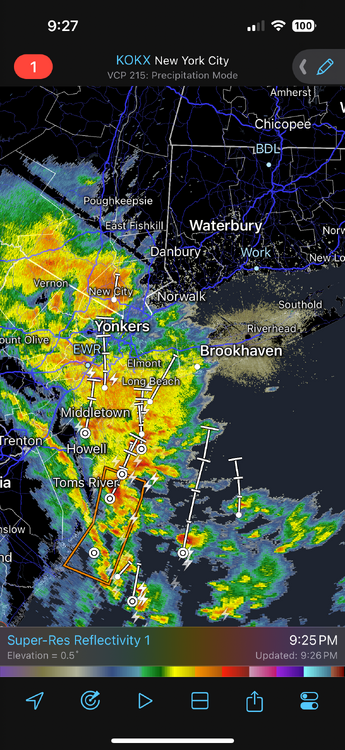
Maybe a nice little light show? Looks like the edge of the elevated instability is pushing towards the shoreline. Wonder if there could be some small hail in these
-
BOOM. My girlfriend is on the FaceTime with a friend who lives in New Jersey in a highrise building and he has the camera facing outside and we saw a sick CG!!!
-
Right
-
made a thread! Who doesn't want to begin the year with damage
-
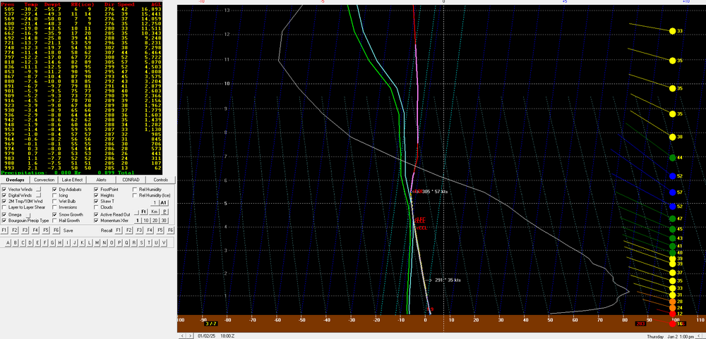
As one of Eminem's songs states, "Cold Wind Blows" and it will be blowing on Thursday. An area of deepening surface low pressure moving northeast across the region Wednesday into Thursday, combined with a large high pressure system building into the mid-South yields a strong pressure gradient across the Northeast Thursday. 925mb winds are expected to be greater than 40 knots region wide with 850mb winds exceeding 50 knots (while weakening through the afternoon). Forecast models indicate the presence of very steep low-level lapse rates region wide with a lapse rate within the lowest 5,000 feet of the atmosphere up around 9 C/KM, indicative of strong low-level mixing. Bufkit model soundings from both the GFS and NAM indicate the potential for widespread wind gusts of 55-60+ mph with sustained winds anywhere from 15-30 mph. While widespread wind advisories are already in place, I would not be surprised if we see some upgrades to a high wind warning over the next day. While the trees are bare which will limit the potential for damage, due to the magnitude and duration of strong winds, scattered power outages are likely along with some downed trees and limbs. There also may be a nice localized pocket of light-to-moderate snow within the Greens of southern Vermont Thursday which could net several-plus inches of accumulation. 12z NAM bufkit for BDL Thursday afternoon. Don't see NAM outmix the GFS too often
-
This is one of the more impressive wind signals we've had in a while I think. The trees are bare so that limits damage potential but there will be some power outages and downed trees.
-
Thursday is going to rip. I also don't recall many times seeing the NAM outmix the GFS. Wonder if we eventually see wind advisories converted to high wind warnings. BDL
-
Wasn't a bad day today. Went outside a bit on a quick lunch before the Bruins game to pick up dog poop now that the grass is fully visibile again...boy was there alot of dog poopy. I looked like Santa carrying his giant sack of gifts
-
wow so we actually have a decent shot to see above-average snow then. May February is Dreambruary for us
-
That's something we're going to have to watch closely...confluence is going to be huge too but we can't lose track of what is happening within the Southwest with the energy and this seems to be an area where models can struggle drastically. Like I mentioned the other day...this could end up being something which gives us a big boost or totally screws us.
-
I really hope the 8th-12th time frame can pan something out. I don't feel very confident or very good about our prospects once the pattern relaxes. I feel like most of the bullets will have been used up by then and once the pattern relaxes its an inactive storm track. But hopefully the relax of the pattern will come with another reload and not a relaxation then do a warmer pattern.
-
crack may actually have more value than snow maps.
-
can we ban posting snow maps beyond 5 days out???
-
Perhaps a shitty evolution or scenario on the 6th opens up more room for something around the 10th
-
One thing too with the 8th-12th time frame is there is some major uncertainty with that energy in the southwest. I bet that is going to end up playing a huge role in whether we're looking at an interior Southeast/mid-Atlantic special or northern mid-Atlantic/Northeast ordeal.


